It looks like you're using an Ad Blocker.
Please white-list or disable AboveTopSecret.com in your ad-blocking tool.
Thank you.
Some features of ATS will be disabled while you continue to use an ad-blocker.

Quake Watch 2014
page: 11share:
reply to post by radpetey
Yeah it went quiet on the 15th with just 2 x M3 quakes, after the M6.4 of the 13th, but seems to have picked up again,
I looked at the newest page on GSAIM Interactive Maps and pulled each daily map down to the area and can see the trend over 12 days.
Which one can do for any area.
Yeah it went quiet on the 15th with just 2 x M3 quakes, after the M6.4 of the 13th, but seems to have picked up again,
I looked at the newest page on GSAIM Interactive Maps and pulled each daily map down to the area and can see the trend over 12 days.
Which one can do for any area.
Did LA just get a couple of quick jolts? I was looking at the ABC7 cam; not sure if I'm seeing 'jolts' or not.
reply to post by muzzy
So Muzzy, in your opinion would you say that we are currently looking at fore-shocks there, ahead of something potentially much larger to come?
So Muzzy, in your opinion would you say that we are currently looking at fore-shocks there, ahead of something potentially much larger to come?
SpaceJockey1
reply to post by muzzy
So Muzzy, in your opinion would you say that we are currently looking at fore-shocks there, ahead of something potentially much larger to come?
I am not muzzy ....not by a long shot!
But this is exactly what happened before the 6.4.
On the other hand, I have seen huge swarms of upper 2's and 3's with no big quake to follow.
We shall see!
nugget1
Did LA just get a couple of quick jolts? I was looking at the ABC7 cam; not sure if I'm seeing 'jolts' or not.
Yes sir! and after the 2nd quake, there appears to be that harmonic looking fuzzy lined thingamajiggy
earthquake.usgs.gov...
abclocal.go.com...
I have an uneasy feeling about this area!
edit on 18-1-2014 by radpetey because: (no reason given)
radpetey
Yes sir! and after the 2nd quake, there appears to be that harmonic looking fuzzy lined thingamajiggy
earthquake.usgs.gov...
abclocal.go.com...
I have an uneasy feeling about this area!
I saw the fuzzy thingamajiggy when it happened; that was from the Mag 5.8 in Japan. I went to hunt it down when I saw it,
5.8
202km N of Chichi-shima, Japan
2014-01-18 05:00:42 UTC9.9 km
No harmonics in the LA Basin that I'm aware of---but plenty of reason to feel uneasy. I have that same pit in my stomach, friend.
edit on
1/18/2014 by Olivine because: (no reason given)
Hmm.
M4.2 - 25km SSW of Bayaguana, Dominican Republic 2014-01-18 07:06:57 UTC
I wonder if this is related to stress redistribution from the PR Trench quake? The only ones for the past 30 days nearest the DR are offshore, not on land like this one.
M4.2 - 25km SSW of Bayaguana, Dominican Republic 2014-01-18 07:06:57 UTC
I wonder if this is related to stress redistribution from the PR Trench quake? The only ones for the past 30 days nearest the DR are offshore, not on land like this one.
reply to post by Olivine
Yes I noticed they made no mention of the 'default' depths and yet clearly their figures MUST be skewed by these.
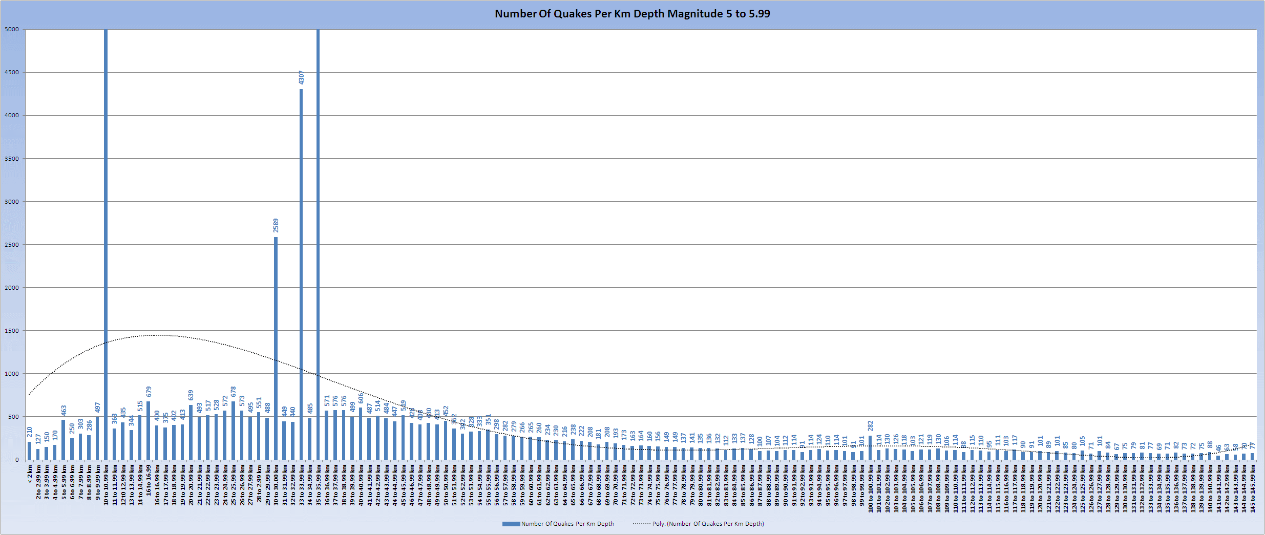
This graph is a work in progress and at present only goes down to 145 km depth and is only using Magnitude 5 earthquakes converted from ML and mb to Mw from 2002 to 2014 - a total of 80,000+ earthquakes.
The defaults depths 10km and apparently 30,33,35 and 100 are clear to see. Visually if you ignore the massive peaks there is a relatively even distribution that increases to around the 30 km mark and then tails off towards 145 km. I have chopped off the top of the big numbers so the smaller ones are more apparent. (See below the image)
Click the image to enlarge
That block around 30km is distributed like this:
495, 27 to 27.99 km
551, 28 to 2.99 km
488, 29 to 29.99 km
2589, 30 to 30.00 km
449, 31 to 31.99 km
440, 32 to 32.99 km
4307, 33 to 33.99 km
485, 34 to 34.99 km
6929, 35 to 35.99 km
571, 36 to 36.99 km
576, 37 to 37.99 km
I cannot imagine that the 35km band is so neatly targeted by Mother Nature and since well in excess of 50% of the values were 35.0 as opposed to greater decimal values, that definitely smacks of defaults. Interesting however that it is not the published default of 33 which has fewer 'hits'
The 10 km depth is massive - 19,356
286, 8 to 8.99 km
497, 9 to 9.99 km
19356, 10 to 10.99 km
363, 11 to 11.99 km
435, 12 t0 12.99 km
I don't have the PDF open but this seems to make a mockery of their 11.6 peak which just is not there. I have to be honest here, I am hopeless at mathematics and I just do not understand how they created the log scale of depths, or why, nor do I understand how their values can be different from straight forward arithmetic.
Looking at a comparison of all depths to only 30 to 49 inclusive form 2010 onwards (all I have in a consistent set at present) then there does seem a dropping off of the numbers just prior to Japan and currently in the 30 to 49 km depths but as stated before in the thread the land element of the MOHO is only 30% or so.

Click the image to enlarge
I am not convinced that this study has any validity in it's present format. Whilst it does appear to show a difference I believe a much deeper study based on a split between land and oceanic MOHO, and accounting for separate seismic areas, is required before the hypothesis is validated.
Something else that struck me are the values of depth "peaks": 5.3, 11.6, 33-43, & 596 kms. Those seem to coincide with the default depth values used by USGS and others (5 km, 10 km, 33 km, & 600 km). Is it possible the defaults have skewed their conclusions?
Yes I noticed they made no mention of the 'default' depths and yet clearly their figures MUST be skewed by these.
This graph is a work in progress and at present only goes down to 145 km depth and is only using Magnitude 5 earthquakes converted from ML and mb to Mw from 2002 to 2014 - a total of 80,000+ earthquakes.
The defaults depths 10km and apparently 30,33,35 and 100 are clear to see. Visually if you ignore the massive peaks there is a relatively even distribution that increases to around the 30 km mark and then tails off towards 145 km. I have chopped off the top of the big numbers so the smaller ones are more apparent. (See below the image)

Click the image to enlarge
That block around 30km is distributed like this:
495, 27 to 27.99 km
551, 28 to 2.99 km
488, 29 to 29.99 km
2589, 30 to 30.00 km
449, 31 to 31.99 km
440, 32 to 32.99 km
4307, 33 to 33.99 km
485, 34 to 34.99 km
6929, 35 to 35.99 km
571, 36 to 36.99 km
576, 37 to 37.99 km
I cannot imagine that the 35km band is so neatly targeted by Mother Nature and since well in excess of 50% of the values were 35.0 as opposed to greater decimal values, that definitely smacks of defaults. Interesting however that it is not the published default of 33 which has fewer 'hits'
The 10 km depth is massive - 19,356
286, 8 to 8.99 km
497, 9 to 9.99 km
19356, 10 to 10.99 km
363, 11 to 11.99 km
435, 12 t0 12.99 km
I don't have the PDF open but this seems to make a mockery of their 11.6 peak which just is not there. I have to be honest here, I am hopeless at mathematics and I just do not understand how they created the log scale of depths, or why, nor do I understand how their values can be different from straight forward arithmetic.
Looking at a comparison of all depths to only 30 to 49 inclusive form 2010 onwards (all I have in a consistent set at present) then there does seem a dropping off of the numbers just prior to Japan and currently in the 30 to 49 km depths but as stated before in the thread the land element of the MOHO is only 30% or so.

Click the image to enlarge
I am not convinced that this study has any validity in it's present format. Whilst it does appear to show a difference I believe a much deeper study based on a split between land and oceanic MOHO, and accounting for separate seismic areas, is required before the hypothesis is validated.
edit on 18/1/2014 by PuterMan because: Ah, the inevitable speeling erra
UPDATE to post by PuterMan
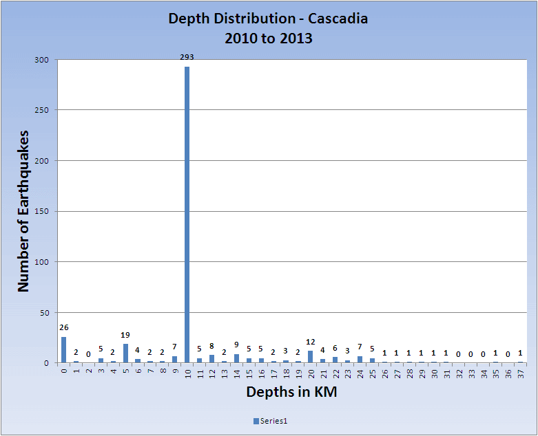
This theory completely falls apart when you looks at individual areas. It may hold good for the western side of the Pacific plate and even possibly round to Japan and Hokkaido but for the Aleutian Arc, Alaska and Casacadia there is such a dearth of 30km to 50 km quakes that in Cascadia for example there are just 3 in the period 2010 to 2013 inclusive. One is not going to see any trend in that!
I have covered the whole of the main deep earthquake areas of the world, and had to change 24 - 49 km to get some areas to show.
The theory seems to work best from Fiji round the circle clockwise to Japan, and maybe South America but it falls apart on the north and north-eastern sides of the plate as I described above.
I think this just goes to show that you cannot apply trends globally to earthquakes as all areas are different. I believe we knew that already, but it seems perhaps that the scientists in this case do not.
I have to go an do some other work having been on this non stop since 1030 UTC = 6+ hours! I need to get a life perhaps!
All the charts for my findings, and of course the data, are in this MS Excel xlsx file (70 KB) which you are welcome to have a look at. You can also read it with Open Office and possibly other programs.
I will leave it up there for a couple of weeks.
And my final parting shot before I said off into the sunset for a while (actually it is pitch black outside)
The depth distribution for Cascadia illustrates just how hopeless the theory is, at least for there.
Click the image to enlarge
This theory completely falls apart when you looks at individual areas. It may hold good for the western side of the Pacific plate and even possibly round to Japan and Hokkaido but for the Aleutian Arc, Alaska and Casacadia there is such a dearth of 30km to 50 km quakes that in Cascadia for example there are just 3 in the period 2010 to 2013 inclusive. One is not going to see any trend in that!
I have covered the whole of the main deep earthquake areas of the world, and had to change 24 - 49 km to get some areas to show.
The theory seems to work best from Fiji round the circle clockwise to Japan, and maybe South America but it falls apart on the north and north-eastern sides of the plate as I described above.
I think this just goes to show that you cannot apply trends globally to earthquakes as all areas are different. I believe we knew that already, but it seems perhaps that the scientists in this case do not.
I have to go an do some other work having been on this non stop since 1030 UTC = 6+ hours! I need to get a life perhaps!
All the charts for my findings, and of course the data, are in this MS Excel xlsx file (70 KB) which you are welcome to have a look at. You can also read it with Open Office and possibly other programs.
I will leave it up there for a couple of weeks.
And my final parting shot before I said off into the sunset for a while (actually it is pitch black outside)
The depth distribution for Cascadia illustrates just how hopeless the theory is, at least for there.

Click the image to enlarge
edit on 18/1/2014 by PuterMan because: To add MOAR!
reply to post by SpaceJockey1
Not necessarily, not all locations show the "San Andreas pattern" of foreshocks before a big quake, in fact very few other places do.
The M6.4 was a subduction quake, and those tend to just pop out of the blue with no warning.
What I see is a classic aftershock sequence where the intial aftershocks happen within the first 12 hours, then there is a pause about the 48 hour mark, and then they carry on after that. I have seen this all over the World after the bigger M6+ quakes.
I believe there will be many more minor-micro aftershocks for weeks, if not months, here. 6.4's can have many hundreds of aftershocks over an extended period of time. sic Christchurch, Seddon etc
Here is a small animation of the last 18 days at Puerto Rico/Virgin Islands.
* most of the plots (waypoints) are USGS data, however all the plots are taken off GSAIM which is multiple networks, so there may be a few duplications, especially M4+ size (yellow icons) eg. see 03/01/2014 where there are 2 x M4's and 2x 3's NW of PR, that is the same quakes, where EMSC and USGS got different locations for each one.
edit on 01u171714 by muzzy because: fixed it up
PuterMan
Looking at a comparison of all depths to only 30 to 49 inclusive form 2010 onwards (all I have in a consistent set at present) then there does seem a dropping off of the numbers just prior to Japan and currently in the 30 to 49 km depths but as stated before in the thread the land element of the MOHO is only 30% or so.
Click the image to enlarge
I appreciate all of the work you've put into the analysis of this paper, PM.
I was looking at your graph above, thinking that maybe a certain ratio threshold of shallow-to-deep quakes (say, 5:1 or higher, for example) might be seen prior to a significant quake, but I just can't hone in on anything.
Keep up the good work--the world needs more critical thinkers like you. Enjoy what is left of your Saturday!
*****************************************
I'm not sure if this earthquake learning module has been posted in previous versions of QW, but here it is.
It's a good resource for those wanting to understand the basics of earthquakes and seismicity, written by the Southern California Earthquake Data Center.
One fun section is, "Is there no way to recognize a foreshock before the mainshock strikes?"
Find it here
It has an associated activity, Recognizing Foreshocks that shows 6 different quake series over 90 days. Each area shown is 50 miles high by 40 miles wide, in southern California, but with no landmarks--so as not to sway your answer.
After watching the earthquakes in the region over 90 days, you have to decide whether to issue an "Alert" or not.
It's an interesting experiment. Of course, we aren't limited to a blank map and 90 days of data when coming to a conclusion about impending quake activity, but it does show how complex the endeavour is.
edit on 1/18/2014 by Olivine because: different thought
edit on 1/18/2014 by Olivine because: (no reason given)
reply to post by Olivine
well you can Always says ...afterschocks from an previous big one..
most common explaination...
well you can Always says ...afterschocks from an previous big one..
most common explaination...
I hope I captured a still shot on the cam! Looks a little bumpy.
abclocal.go.com...
abclocal.go.com...
edit on 18-1-2014 by radpetey because: (no reason given)
reply to post by radpetey
Interesting article here they sent this out to us by e-mail
Eight Seconds of Terror
Twenty years ago, Southern California was rocked by a devastating 6.7 earthquake
www.jpl.nasa.gov...
Interesting article here they sent this out to us by e-mail
Eight Seconds of Terror
Twenty years ago, Southern California was rocked by a devastating 6.7 earthquake
www.jpl.nasa.gov...
radpetey
I hope I captured a still shot on the cam! Looks a little bumpy.
abclocal.go.com...edit on 18-1-2014 by radpetey because: (no reason given)
so does anyone know what the go is ?????. is it not working ???? not sure if its just my connection or not
bellagirl
radpetey
I hope I captured a still shot on the cam! Looks a little bumpy.
abclocal.go.com...edit on 18-1-2014 by radpetey because: (no reason given)
so does anyone know what the go is ?????. is it not working ???? not sure if its just my connection or not
I've been checking all evening, and it hasn't moved.
I wonder who stuck their gum on the needle? So not funny.
nugget1
bellagirl
radpetey
I hope I captured a still shot on the cam! Looks a little bumpy.
abclocal.go.com...edit on 18-1-2014 by radpetey because: (no reason given)
so does anyone know what the go is ?????. is it not working ???? not sure if its just my connection or not
I've been checking all evening, and it hasn't moved.
I wonder who stuck their gum on the needle? So not funny.
thanks mate. didn't realise how much I miss it.
reply to post by Olivine
I don't believe the global model is any use at all. I have created the areas I indicated in the addendum to my post and I am now going through them collecting the data together into depth bands for each area. I had no Mag 4 data before 2010 which is why those charts start at 2010, but I have now assimilated 250,000+ new mag 4 records into the collective giving me mag 4+ data back to 1963 from ANSS. I have to load them into my database as the manipulations required are much easier in SQL Transact queries - never mind - I just need to do it!
Unfortunately filling the missing months where there are no events to keep a consecutive progression of months is VERY time consuming so i think I shall write some code in QVSData to do it, which will mean it can be re-run every month to see what is going on.
The very delayed Jan 10 geophysical report is available now (See my signature). I seem to be having a problem with time. Wonder why that might be..... Jan 17 report in a day or two I hope.

Click the image to enlarge
I was looking at your graph above, thinking that maybe a certain ratio threshold of shallow-to-deep quakes (say, 5:1 or higher, for example) might be seen prior to a significant quake, but I just can't hone in on anything.
I don't believe the global model is any use at all. I have created the areas I indicated in the addendum to my post and I am now going through them collecting the data together into depth bands for each area. I had no Mag 4 data before 2010 which is why those charts start at 2010, but I have now assimilated 250,000+ new mag 4 records into the collective giving me mag 4+ data back to 1963 from ANSS. I have to load them into my database as the manipulations required are much easier in SQL Transact queries - never mind - I just need to do it!
Unfortunately filling the missing months where there are no events to keep a consecutive progression of months is VERY time consuming so i think I shall write some code in QVSData to do it, which will mean it can be re-run every month to see what is going on.
The very delayed Jan 10 geophysical report is available now (See my signature). I seem to be having a problem with time. Wonder why that might be..... Jan 17 report in a day or two I hope.

Click the image to enlarge
UPDATE to post by PuterMan
I managed to get the geophysical report for the week ending the 17th done as well.
See my signature for the link.
I managed to get the geophysical report for the week ending the 17th done as well.
See my signature for the link.
new topics
-
Animated short - Kingdom - In Shadow - A glimmer of hope for the downtrodden
Philosophy and Metaphysics: 7 minutes ago -
Messages of Hope - Let’s have a Shadow Celebration
Dreams & Predictions: 12 minutes ago -
ATS lives on...
General Chit Chat: 45 minutes ago -
Green Irony: Massive US Lithium Source Found - In Fracking Wastewater
Global Meltdown: 1 hours ago -
Helicopter carrying Iran’s president suffers a ‘hard landing,’ state TV says without further d
Breaking Alternative News: 2 hours ago -
Benny Gantz Issues Ultimatum to Netanyahu with Threat to Resign
Middle East Issues: 4 hours ago -
A duel between two cats and crows as seconds
ATS Skunk Works: 9 hours ago
top topics
-
Madness will ensue here. Be ready.
General Chit Chat: 15 hours ago, 10 flags -
BIG REVEAL | Intelligence advisor says ‘catastrophic disclosure’ about UFOs may be on horizon
Aliens and UFOs: 14 hours ago, 9 flags -
A duel between two cats and crows as seconds
ATS Skunk Works: 9 hours ago, 9 flags -
Political Commentator Alice Stewart Supposedly Died of Natural Causes on a Sidewalk Last Night.
General Conspiracies: 14 hours ago, 8 flags -
ATS lives on...
General Chit Chat: 45 minutes ago, 8 flags -
Helicopter carrying Iran’s president suffers a ‘hard landing,’ state TV says without further d
Breaking Alternative News: 2 hours ago, 7 flags -
FO!!! FO!! FO!!...dammit!!
Food and Cooking: 16 hours ago, 4 flags -
Green Irony: Massive US Lithium Source Found - In Fracking Wastewater
Global Meltdown: 1 hours ago, 2 flags -
Benny Gantz Issues Ultimatum to Netanyahu with Threat to Resign
Middle East Issues: 4 hours ago, 2 flags -
James O keefe from Veritas controlled opposition.
Medical Issues & Conspiracies: 14 hours ago, 2 flags
active topics
-
Helicopter carrying Iran’s president suffers a ‘hard landing,’ state TV says without further d
Breaking Alternative News • 37 • : CarlLaFong -
ATS lives on...
General Chit Chat • 9 • : EmmanuelGoldstein -
-@TH3WH17ERABB17- -Q- ---TIME TO SHOW THE WORLD--- -Part- --44--
Dissecting Disinformation • 1066 • : 777Vader -
Madness will ensue here. Be ready.
General Chit Chat • 31 • : TzarChasm -
Gaza Genocide Real or Propaganda
Middle East Issues • 629 • : Xtrozero -
Animated short - Kingdom - In Shadow - A glimmer of hope for the downtrodden
Philosophy and Metaphysics • 0 • : KnowItAllKnowNothin -
10 Year Old Indiana Boy Victim of Bullying Commits Suicide
Education and Media • 45 • : dragonridr -
Messages of Hope - Let’s have a Shadow Celebration
Dreams & Predictions • 1 • : WhiteRabbitCanada -
Benny Gantz Issues Ultimatum to Netanyahu with Threat to Resign
Middle East Issues • 15 • : 5thHead -
WATCH 1740 Russian Soldiers Destroyed By Ukrainian Forces While Advancing In Kharkiv
World War Three • 196 • : Oldcarpy2