It looks like you're using an Ad Blocker.
Please white-list or disable AboveTopSecret.com in your ad-blocking tool.
Thank you.
Some features of ATS will be disabled while you continue to use an ad-blocker.

Quake Watch 2013
page: 60share:
reply to post by aLLeKs
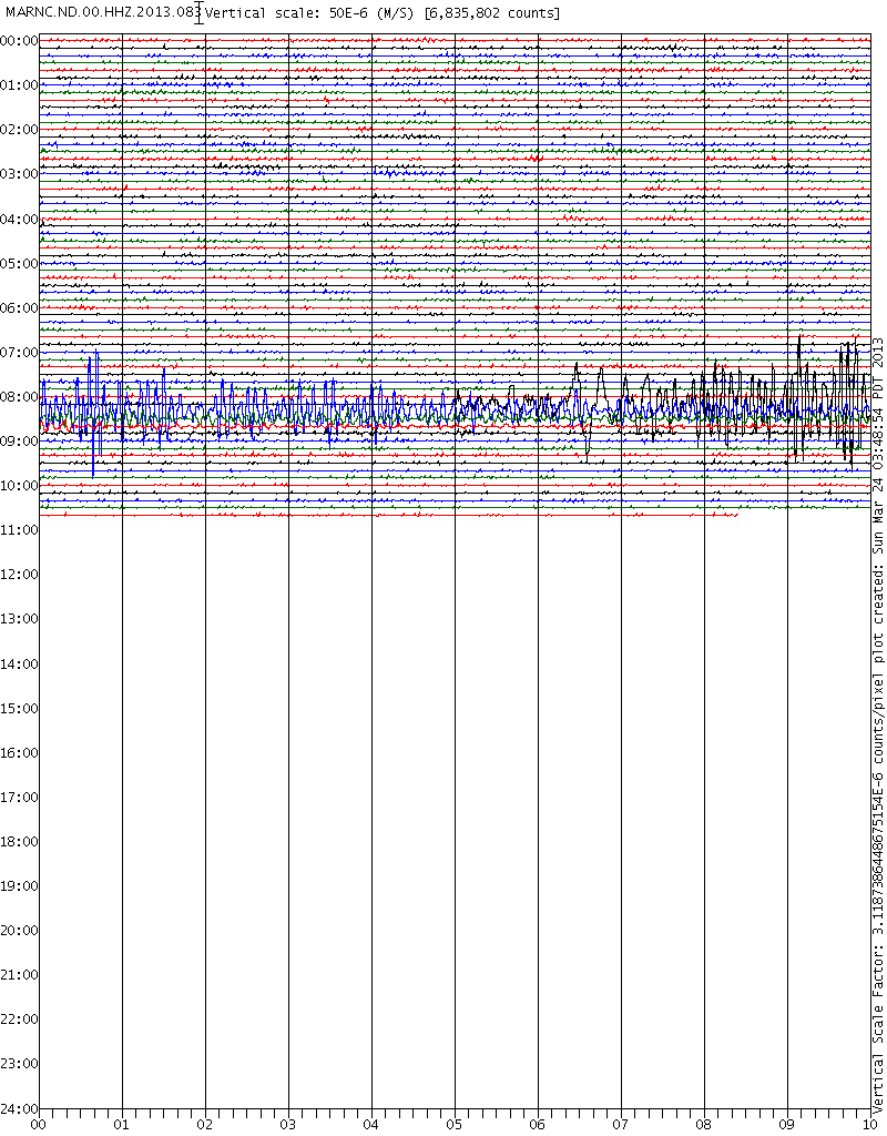
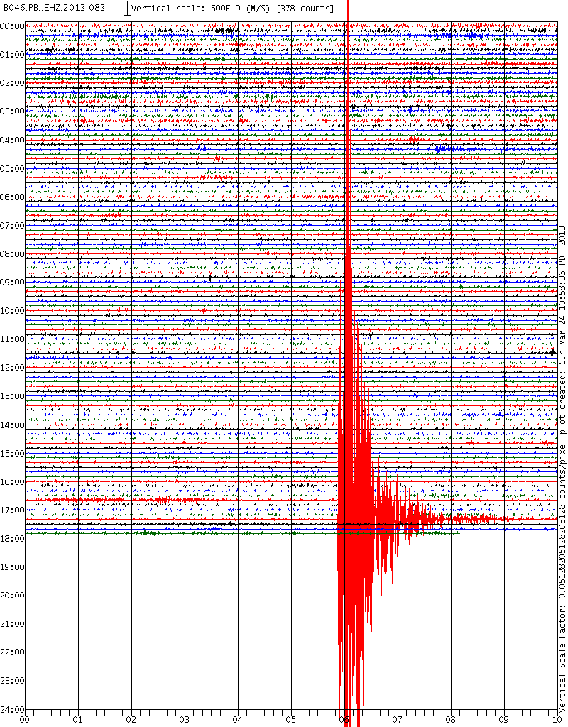
I think they are broken. If you look at the seismograms I have stored you can see there are frequent breaks. Maybe the last one was a bigger one.
Of course you might be right. They could have taken it out of the network but the IRIS catalogue has not caught up yet.
I think they are broken. If you look at the seismograms I have stored you can see there are frequent breaks. Maybe the last one was a bigger one.
Of course you might be right. They could have taken it out of the network but the IRIS catalogue has not caught up yet.
Strange EQ in Oliver British Columbia yesterday caught it on my twitter feed going through it this morning.
2.6 Mag and the official release from USGS was that it was a Quarry blast, did a google search and found that in January as well around same magnitude same explanation.
Oliver BC EQ 2.6
Just how big of an explosion is needed to create a 2.6 mag EQ and just how often are EQ's tagged "Quarry blast" I can say that for sometime I have been watching USGS and can say this may be the first time I have seen such a designation.
SaneThinking
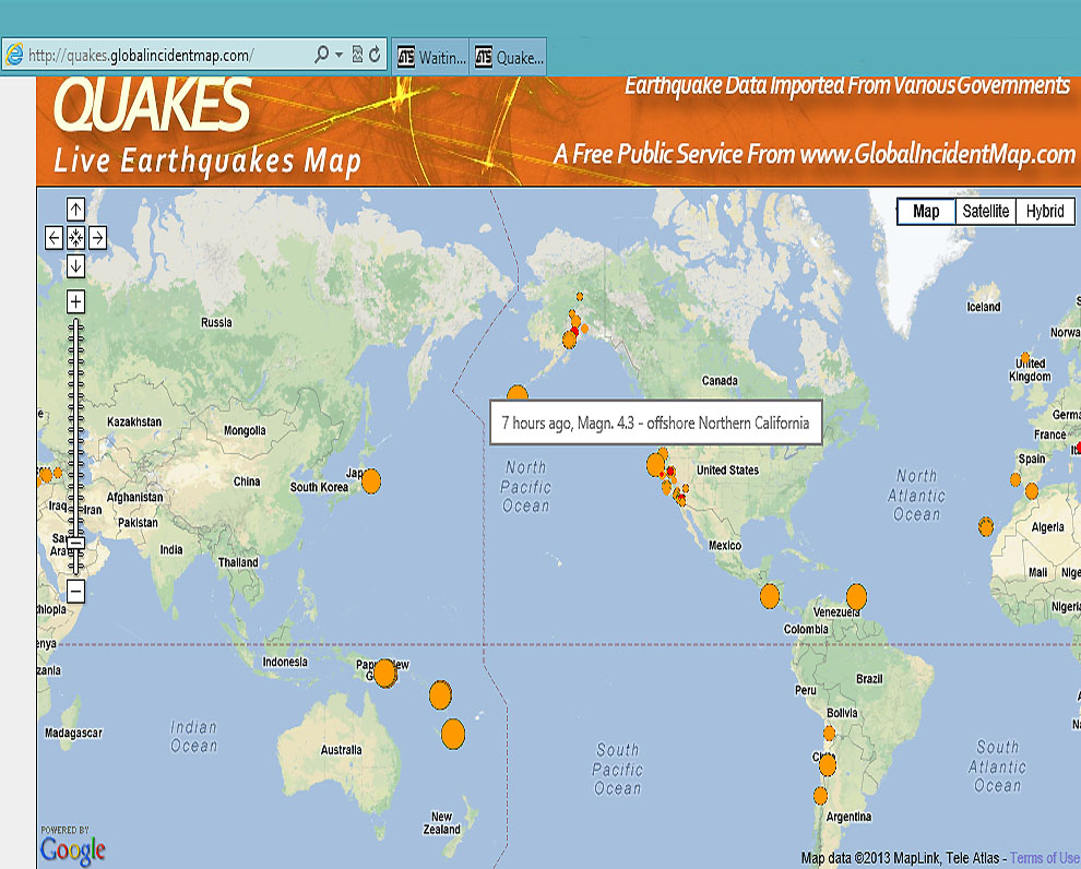
Hmmm, here is a small cracker mag 3.9 Mag 4.3 at the
toe/trench of the southern locked end of the CSZ. Very shallow on preliminary data.
edit on 3/24/2013 by Olivine because: mag
change
edit on 3/24/2013 by Olivine because: add the image for future examination
Ok.... Quake Watch. I am Quake watchin.
WTH is this below? lol I know its an EQ but never have seen this area before show up on the list.
Also, is Oregon swarming?
One more question... the 4.3 off shore N. Cali.... where can I find the past data as I didn't find much on USGS and of course I was in a hurry so may have overlooked it. It doesn't appear to have had a bigger EQ in that area. Smaller ones, yes. I did see those. Was there one recently that was bigger than 4.3?
ETA: Olivine 0.6 is very shallow!!
WTH is this below? lol I know its an EQ but never have seen this area before show up on the list.
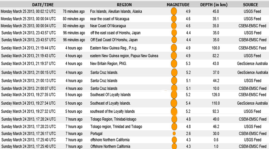
MAP 4.8 2013/03/24 17:28:24 11.852 -60.148 46.2 TOBAGO REGION, TRINIDAD AND TOBAGO
Also, is Oregon swarming?
One more question... the 4.3 off shore N. Cali.... where can I find the past data as I didn't find much on USGS and of course I was in a hurry so may have overlooked it. It doesn't appear to have had a bigger EQ in that area. Smaller ones, yes. I did see those. Was there one recently that was bigger than 4.3?
ETA: Olivine 0.6 is very shallow!!
edit on 24-3-2013 by MamaJ because: (no reason given)
reply to post by MamaJ
Hi MamaJ
Sorry,I don't know much about the Trinidad & Tobago region; maybe someone else can jump in on that one.
The little swarm in Oregon is interesting. It's in a region of old (20,000 year old +/-) cinder cones on top of basalt shield volcanoes (lavas that are more runny versus explosive). I see 2 smaller ones that haven't been listed since the mag 2.6 at 18:46 UTC.
The area offshore of northern California had a mag 6.5 back in 2010. While looking at that link, I noticed the location on their map is wrong. The coordinates would make it a bit closer to shore. So yeah, bigger ones happen there.
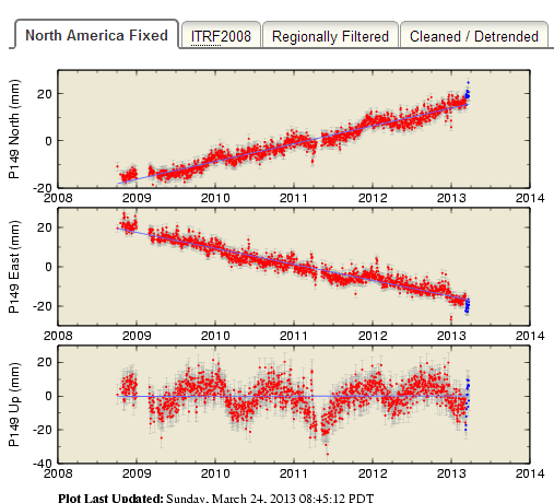
Those 5 little quakes at 21:20 UTC today near Reno, NV got me looking at the GPS in the whole region.
A large quake in Reno is possible, and that is a substantial population center. There was a mag 4.7 in the same area in 2008. This is from the Univ of Nevada, Reno
Okay, back to the GPS. Check out the recent "push" to the West and North over the past few days. This first station is P149, just west of Reno:
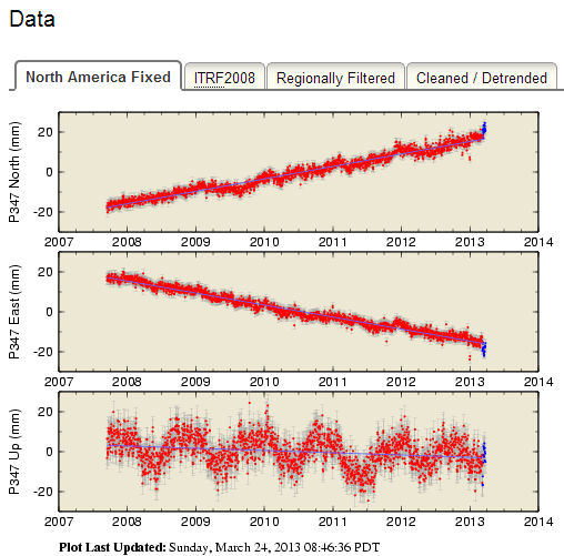
Travel north-northwest about 180 kms to station P347,--the same acceleration to the NW:
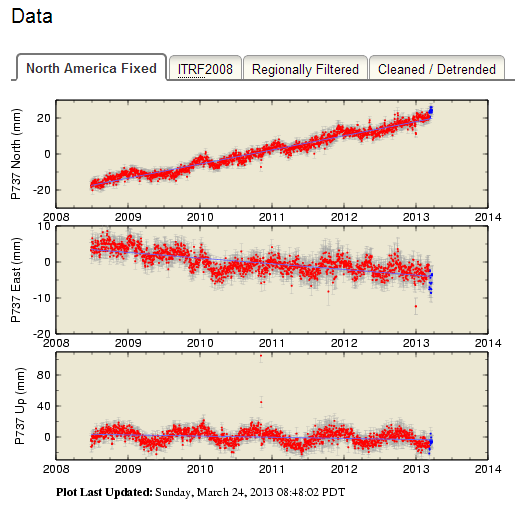
This last example is just NW of the small earthquake swarm in southern Oregon, station P737:
All of these stations and a 100+ more can be found on the USGS GPS Northern California Network. Just click on the blue squares.
Stations closer to the coast show an even stronger westward movement over recent days.
I don't know, but to me, a 1 centimeter movement over only a weeks' time, over so large an area...it just looks like a larger earthquake could be in the works soon. Also, there hasn't been a sustained tremor episode in this area lately--so this movement isn't the associated slip of an ETS.
To see the general direction of movement, relative to the North American continent, see this GPS velocity map. The longer the arrow, the faster the movement/year.
Hi MamaJ
Sorry,I don't know much about the Trinidad & Tobago region; maybe someone else can jump in on that one.
The little swarm in Oregon is interesting. It's in a region of old (20,000 year old +/-) cinder cones on top of basalt shield volcanoes (lavas that are more runny versus explosive). I see 2 smaller ones that haven't been listed since the mag 2.6 at 18:46 UTC.
The area offshore of northern California had a mag 6.5 back in 2010. While looking at that link, I noticed the location on their map is wrong. The coordinates would make it a bit closer to shore. So yeah, bigger ones happen there.
Those 5 little quakes at 21:20 UTC today near Reno, NV got me looking at the GPS in the whole region.
A large quake in Reno is possible, and that is a substantial population center. There was a mag 4.7 in the same area in 2008. This is from the Univ of Nevada, Reno
There are at least two faults running into the city limits that may be capable of a large, damaging earthquake of magnitude 7 or more, larger than the Northridge earthquake in January 1994. There are many more apparently smaller faults.
Okay, back to the GPS. Check out the recent "push" to the West and North over the past few days. This first station is P149, just west of Reno:
Travel north-northwest about 180 kms to station P347,--the same acceleration to the NW:
This last example is just NW of the small earthquake swarm in southern Oregon, station P737:
All of these stations and a 100+ more can be found on the USGS GPS Northern California Network. Just click on the blue squares.
Stations closer to the coast show an even stronger westward movement over recent days.
I don't know, but to me, a 1 centimeter movement over only a weeks' time, over so large an area...it just looks like a larger earthquake could be in the works soon. Also, there hasn't been a sustained tremor episode in this area lately--so this movement isn't the associated slip of an ETS.
To see the general direction of movement, relative to the North American continent, see this GPS velocity map. The longer the arrow, the faster the movement/year.
edit on 3/24/2013 by Olivine because: fixing some gaffs
edit on 3/24/2013 by Olivine because: (no reason
given)
edit on 3/24/2013 by Olivine because: (no reason given)
reply to post by SaneThinking
If you look at Magnitude Calcs in my signature you will see that a 2.6 is about 120kg of TNT. Not that much really.
You can find a daily list of mine explosions here
Explosions are not normally shown on the earthquake listings.
Just how big of an explosion is needed to create a 2.6 mag EQ and just how often are EQ's tagged "Quarry blast" I can say that for sometime I have been watching USGS and can say this may be the first time I have seen such a designation.
If you look at Magnitude Calcs in my signature you will see that a 2.6 is about 120kg of TNT. Not that much really.
You can find a daily list of mine explosions here
Explosions are not normally shown on the earthquake listings.
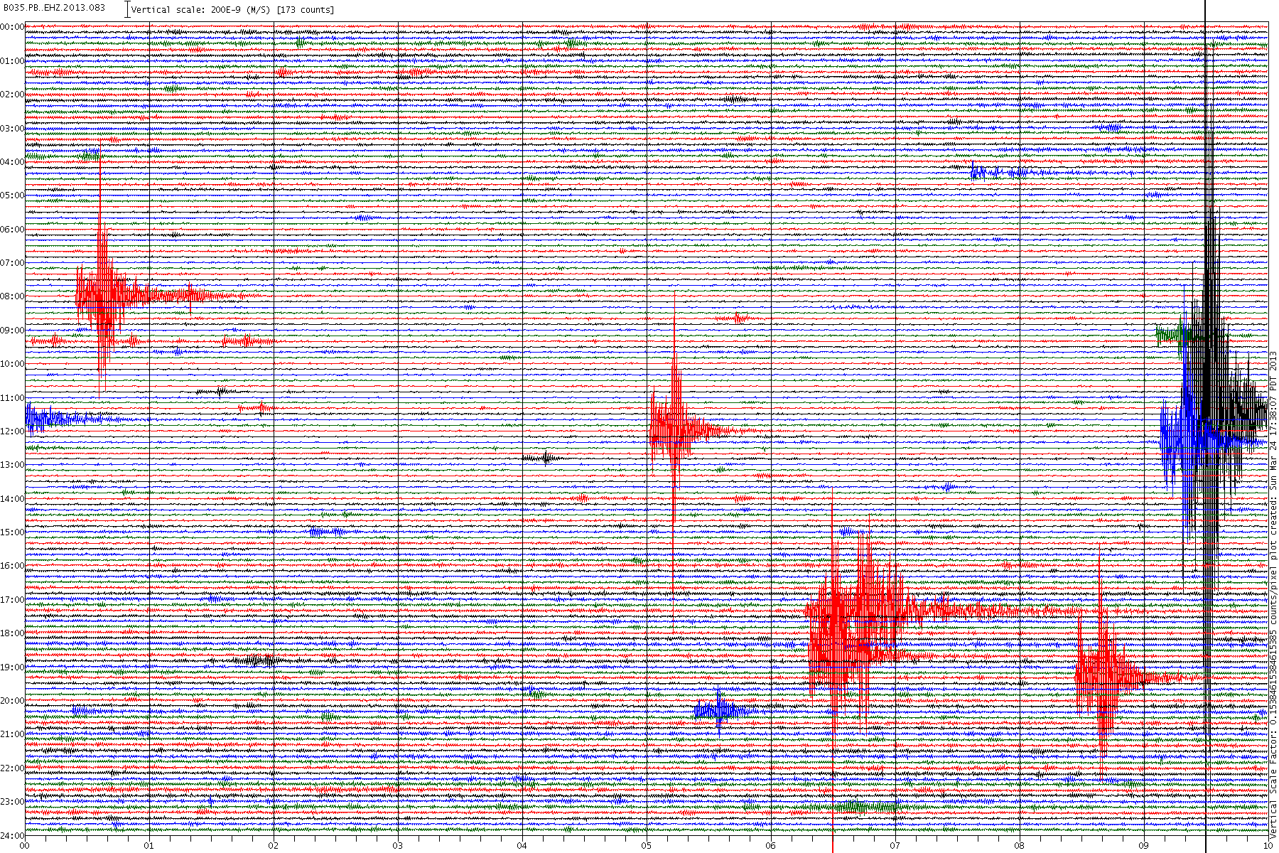
reply to post by Olivine
No no no, they are not quakes on that seismo, in fact it is not a seismogram but a picture of feeshez swimi' in da tank.
Click it to see bigger feeshez
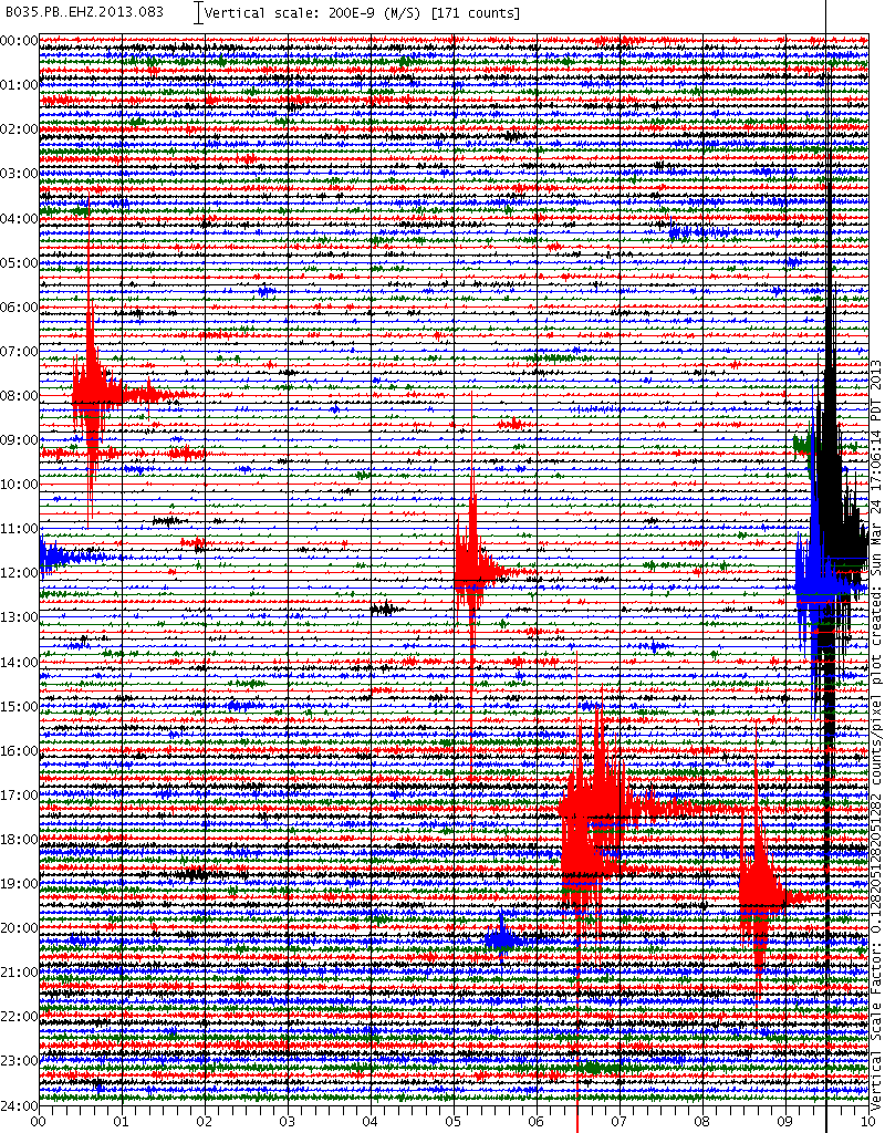
No no no, they are not quakes on that seismo, in fact it is not a seismogram but a picture of feeshez swimi' in da tank.
Click it to see bigger feeshez
reply to post by MamaJ
All I can dredge up from my USGS data are these in a 200 km radius
However the same radius search on the Centennial catalogue brings up some larger ones
Looks like April 1997 was a busy time in the area, and prior to that March 1988
And a whole bunch more if I search the ANSS data I hold
All I can dredge up from my USGS data are these in a 200 km radius
2009-04-01T02:03:25.000Z 10.44710 -61.18050 4.4000 Trinidad. Trinidad and Tobago 192.6
2012-02-11T07:19:04.000Z 12.38810 -60.16420 4.6000 Barbados region. Windward Islands 59.6
2013-03-24T17:28:23.000Z 11.85240 -60.14830 4.8000 Tobago region. Trinidad and Tobago 0.1
However the same radius search on the Centennial catalogue brings up some larger ones
1910-01-23T18:49:42.000Z 12.00000 -60.50000 6.9000 41.7
1988-03-10T06:17:24.920Z 10.27000 -60.58600 6.7000 182.3
1988-03-12T04:32:11.630Z 10.13700 -60.57800 5.8000 196.4
1988-03-16T05:48:04.150Z 10.20700 -60.59500 5.7000 189.3
1988-06-24T08:57:55.150Z 10.16500 -60.57100 5.9000 193.2
1994-05-03T16:36:45.840Z 10.27500 -60.72900 6.0000 186.5
1997-04-02T06:14:32.560Z 11.39800 -61.17000 6.1000 122.2
1997-04-22T09:31:26.850Z 11.12200 -61.05800 6.7000 128.1
1997-04-22T10:11:49.220Z 11.08600 -60.95700 5.7000 122.6
Looks like April 1997 was a busy time in the area, and prior to that March 1988
And a whole bunch more if I search the ANSS data I hold
1967-05-31T11:38:39.700Z 12.51500 -60.29800 5.2000 75.5
1981-03-02T07:54:07.800Z 12.34300 -60.31400 5.1000 57.5
1982-09-20T16:26:44.290Z 11.22100 -60.84700 5.2000 103.5
1984-02-11T13:57:45.030Z 12.09000 -60.03200 5.3000 29.3
1984-10-05T10:30:50.290Z 11.69000 -60.17300 5.6000 18.2
1985-11-28T00:13:59.660Z 11.75800 -61.38900 5.3000 135.5
1986-04-11T12:59:06.900Z 12.28800 -59.43400 5.0000 91.5
1988-03-10T06:17:23.310Z 10.40200 -60.58700 6.2000 168.2
1988-03-10T06:30:25.470Z 10.39600 -60.57700 5.4000 168.5
1988-03-10T06:33:24.340Z 10.38700 -60.50400 5.1000 167.5
1988-03-11T16:01:07.010Z 10.16700 -60.60300 5.2000 193.8
1988-03-12T04:32:10.300Z 10.14400 -60.56900 5.7000 195.4
1988-03-13T17:00:25.700Z 10.21000 -60.16900 5.1000 182.6
1988-03-16T05:48:03.810Z 10.21100 -60.60700 5.7000 189.2
1988-03-25T16:20:47.160Z 10.17600 -60.60400 5.2000 192.9
1988-06-24T08:57:53.330Z 10.20900 -60.55900 6.0000 188.1
1988-06-26T07:03:24.800Z 10.31100 -60.57500 5.0000 177.6
1990-03-14T03:33:17.340Z 10.21200 -59.80000 5.1000 186.3
1992-08-19T00:36:14.100Z 11.74300 -60.82400 5.1000 74.6
1992-08-20T20:23:36.760Z 11.32300 -59.32300 5.1000 107.4
1994-05-03T16:36:43.650Z 10.24100 -60.75800 5.8000 191.1
1994-05-03T16:56:19.070Z 10.26800 -60.59500 5.1000 182.8
1994-06-01T03:13:47.150Z 11.91300 -60.99800 5.5000 92.7
1996-01-01T09:38:25.490Z 11.23300 -61.71700 5.4000 184.3
1997-04-02T06:14:31.090Z 11.41200 -60.94200 6.2000 99.4
1997-04-08T17:11:53.640Z 11.04900 -60.78500 5.2000 113.1
1997-04-22T09:31:23.250Z 11.11200 -60.89200 6.7000 115.5
1997-04-22T10:11:44.790Z 11.02900 -60.95700 5.6000 127.1
1997-04-22T10:18:53.440Z 11.05700 -61.16900 5.0000 142.1
1997-04-22T10:22:43.390Z 11.04900 -60.84000 5.0000 116.9
1997-04-25T16:04:50.160Z 11.13600 -61.02400 5.0000 124.3
1997-05-04T01:44:50.700Z 11.02700 -60.97500 5.5000 128.6
1998-07-22T16:21:27.800Z 12.11300 -60.73800 5.0000 70.4
2001-02-17T20:55:32.960Z 10.72400 -61.04900 5.0000 159.3
2003-06-21T05:55:56.800Z 10.66700 -59.36900 5.3000 156.8
2008-07-03T06:34:53.700Z 10.28100 -60.44200 5.8000 177.6
2010-07-25T13:18:30.920Z 10.59400 -60.71400 4.1000 152.9
2010-11-09T11:50:56.910Z 11.06700 -58.99300 4.1000 153.2
2010-12-12T02:41:25.230Z 11.75600 -59.36800 4.1000 85.6
2011-02-21T05:28:49.560Z 10.31600 -60.34300 4.2000 172.1
2011-03-16T19:18:59.750Z 10.12800 -60.57800 4.6000 197.4
2011-07-14T06:35:31.270Z 11.23000 -61.83900 4.3000 196.8
2012-02-11T07:19:03.500Z 12.44300 -60.21900 4.6000 66.2
2012-02-18T02:22:06.800Z 11.96400 -61.41600 4.0000 138.5
2012-08-21T10:45:29.400Z 10.61300 -60.39600 4.1000 140.4
2012-08-28T23:27:54.400Z 13.18100 -60.74300 4.0000 161.3
I dunno guys... Many 4s and 5s in the last 7 hours. This is as of 9:20pm Sunday night. So they started at 2:20 EST.
Main map
Lots of 4s and 5s... (with all but one of the small ones deleted). 18 total so far.
Cause for concern?
Main map
Lots of 4s and 5s... (with all but one of the small ones deleted). 18 total so far.
Cause for concern?
edit on 24/3/2013 by MarkJS because: replaced with better, sharpened pictures
edit on 24/3/2013 by MarkJS because: (no reason
given)
Originally posted by aLLeKs
Next one...
M6.0 - 162km NW of Ceva-i-Ra, Fiji 2013-03-24 08:13:44 UTC
Location
20.777°S 173.407°E depth=10.0km (6.2mi)
Nearby Cities
162km (101mi) NW of Ceva-i-Ra, Fiji
534km (332mi) SW of Nadi, Fiji
603km (375mi) WSW of Suva, Fiji
631km (392mi) ESE of Port-Vila, Vanuatu
639km (397mi) E of We, New Caledonia
Huh? never heard of Ceva-i-Ra Fiji
Oh its the Vanuatu quake.
I think USGS dropping the 7 days list is a big mistake.. that interactivemapthingy is confusing, why don't they just put the F_E Region in the list below their map like everyone else does .grrr
I put it into Google Earth and I see that it was on an Oceanic Spreading Rift, may cause more quakes to the West and East.
Not much history there.
edit on 24-3-2013 by muzzy because: (no reason given)
reply to post by MarkJS
Started a thread about the supposed swarm. Turns out that a lot of the logged entries are duplicates. So essentially there are possibly only eight 4s and 5s net. Not so bad... Maybe it's nothing then for now... hopefully.
Started a thread about the supposed swarm. Turns out that a lot of the logged entries are duplicates. So essentially there are possibly only eight 4s and 5s net. Not so bad... Maybe it's nothing then for now... hopefully.
edit on 24/3/2013 by MarkJS because: (no reason given)
reply to post by MarkJS
I'd worry more about all the very small 0.5-1.5 quakes in throughout California. Watch the area between just south of the Queen Charlotte islands and the southern most part of California(and maybe buy a person floatation device/life-jacket).
I'd worry more about all the very small 0.5-1.5 quakes in throughout California. Watch the area between just south of the Queen Charlotte islands and the southern most part of California(and maybe buy a person floatation device/life-jacket).
reply to post by MarkJS
Bearing in mind first that the past week has been quiet, see the stats (and charts) in my Geophysical report, then the current week's total of 18 is actually still a little bit on the low side for a 7 day period which at the current average of 4 per day should be 28 to be 'on target'.
So, in my opinion for what it is worth, not a cause for concern just a return towards normal from a wee quiet spell BUT the mag 7 gap is now 44 days and double the average gap so ...........
Seems like the two 6ers started to trigger normal activity again. But anyway look at the triangle between: Papua New Guinea, New Zealand and Samoa...
I would still go for a big one down there (again)
Or somewhere at Puerto Rico
Or somewhere at Puerto Rico
edit on 25-3-2013 by aLLeKs because: (no reason given)
reply to post by aLLeKs
I would watch the pacific Northwest for the next few months. I feel the shaking at least 3 times a week(a VERY weak shaking,but it is there). There is also something else but I can not explain it(the strangeness started on the 11-12 of February,2013).
I would watch the pacific Northwest for the next few months. I feel the shaking at least 3 times a week(a VERY weak shaking,but it is there). There is also something else but I can not explain it(the strangeness started on the 11-12 of February,2013).
Southern Atlantic a little riled up too.
earthquake.usgs.gov...
M5.2 - Southwestern Atlantic Ocean
2013-03-22 14:18:58 UTC
earthquake.usgs.gov...
M5.2 - Southwestern Atlantic Ocean
2013-03-22 14:18:58 UTC
next... earthquake.usgs.gov...
M5.2 - 287km SW of Panenggoede, Indonesia 2013-03-25 11:54:55 UTC
Location
11.495°S 117.182°E depth=10.0km (6.2mi)
Nearby Cities
287km (178mi) SW of Panenggoede, Indonesia
324km (201mi) SSE of Praya, Indonesia
332km (206mi) S of Sumbawa Besar, Indonesia
342km (213mi) SSE of Mataram, Indonesia
975km (606mi) WSW of Dili, East Timor
new topics
-
Official denial
Diseases and Pandemics: 2 hours ago -
MEGA - Let's Make Europe Great Again
Other Current Events: 2 hours ago -
Hamas and Other Islamist Terrorist Groups Announce Support of US Campus Anti-Israel Protests
Education and Media: 3 hours ago -
Psychotronic Operation Rwanda Who Wants To Be A Refugee?
ATS Skunk Works: 3 hours ago -
AI phrenology
Science & Technology: 10 hours ago
top topics
-
4/27/24 New Jersey Earthquake
Fragile Earth: 16 hours ago, 8 flags -
AI phrenology
Science & Technology: 10 hours ago, 4 flags -
Psychotronic Operation Rwanda Who Wants To Be A Refugee?
ATS Skunk Works: 3 hours ago, 3 flags -
Hamas and Other Islamist Terrorist Groups Announce Support of US Campus Anti-Israel Protests
Education and Media: 3 hours ago, 3 flags -
MEGA - Let's Make Europe Great Again
Other Current Events: 2 hours ago, 1 flags -
Official denial
Diseases and Pandemics: 2 hours ago, 0 flags
active topics
-
MEGA - Let's Make Europe Great Again
Other Current Events • 9 • : Freeborn -
Canada caught red-handed manipulating live weather data and make it warmer
Fragile Earth • 27 • : Justoneman -
Psychotronic Operation Rwanda Who Wants To Be A Refugee?
ATS Skunk Works • 4 • : stonerwilliam -
Joe Biden Facing Criminal Charges In Ukraine
Mainstream News • 96 • : Justoneman -
What allies does Trump have in the world?
ATS Skunk Works • 7 • : Justoneman -
AI phrenology
Science & Technology • 15 • : Hecate666 -
Official denial
Diseases and Pandemics • 4 • : Lochid -
-@TH3WH17ERABB17- -Q- ---TIME TO SHOW THE WORLD--- -Part- --44--
Dissecting Disinformation • 714 • : Justoneman -
Killings of Palestinian children are soaring in the West Bank.
World War Three • 163 • : Terpene -
Hamas and Other Islamist Terrorist Groups Announce Support of US Campus Anti-Israel Protests
Education and Media • 5 • : FlyersFan