It looks like you're using an Ad Blocker.
Please white-list or disable AboveTopSecret.com in your ad-blocking tool.
Thank you.
Some features of ATS will be disabled while you continue to use an ad-blocker.

Quake Watch 2013
page: 150share:
I found the original table. Unfortunately I cannot link it as a source as the web page is 404. I have dumped it into excel and created this table for
anyone who is interested.
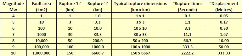
Click for a larger version
Bear in mind that the surface area of rupture is the important component and if the length increases then the height/depth decreases and vice versa.
The original only went to Mag 8 so I extended it to Mag 10 and added some very rule of thumb calcs for rupture time and displacement.
reply to post by PuterMan
I didn't even think about comparing the solar cycle of 1812-15ish until you mentioned it but it absolutely fits. If we are indeed going into something similar we can look at the new madrid quake in 1812 and attempt to find accounts from other parts of the world.
But how would a solar minimum of this magnitude affect the earth? After 200 years how have faults changed - could it potentially be more devastating - could and could not. How, if at all does all of the drilling affect this? I understand it is all a bit much but it's worth digging into recorded of everything going on at that time period. I guess I should begin digging. Thank you for a historical time period to focus on. I believe there are native american accounts of yellowstone about this time as well - staying away from it as feared it but I need to verify that.
reply to post by PuterMan
Thank you on the gooey cake mix analogy:-). I do stuff like this to better understand (in this case visualizing something I can manipulate to mimic the earth). If one already doesnt exist I think it would be great for professors in particular, to create a model - would need model of sun to scale - so magnets maybe for that. But making a mini replica of the earth would be difficult. I guess it stays in my head for now so thanks for fine tuning my elementary reasoning. It helps to build understanding
Thank you on the gooey cake mix analogy:-). I do stuff like this to better understand (in this case visualizing something I can manipulate to mimic the earth). If one already doesnt exist I think it would be great for professors in particular, to create a model - would need model of sun to scale - so magnets maybe for that. But making a mini replica of the earth would be difficult. I guess it stays in my head for now so thanks for fine tuning my elementary reasoning. It helps to build understanding
reply to post by Dianec
Go to it! I look forward to your findings.
I just don't have enough hours in the day, days in the week or months in the years to get everything done that I need to do let alone want to do.
Go to it! I look forward to your findings.
I just don't have enough hours in the day, days in the week or months in the years to get everything done that I need to do let alone want to do.
reply to post by PuterMan
Thanks for the links and info, Puterman. And for your kind words.
They sound reasonable.
We are likely . . . LOL . . . a good balance for one another on such issues.
I sure hope the conservative perspective on the island landslide stuff works out most accurate.
Blessings,
Thanks for the links and info, Puterman. And for your kind words.
They sound reasonable.
We are likely . . . LOL . . . a good balance for one another on such issues.
I sure hope the conservative perspective on the island landslide stuff works out most accurate.
Blessings,
I love the discussion that has been ongoing the past few pages. Kudos to everyone involved.
I'm going to have to disagree with you and USGS on this point.
New modelling done by Nadia Lapusta of Caltech(and others), shows that creeping segments may dynamically weaken when slammed by a rupture, greatly increasing the fault length and earthquake magnitude.
This snippet is from the write-up describing the paper published in Nature 9 January 2013, which of course, is paywalled.
...and further down the page...
Most quakes on the San Andreas happen at depths between 8 and 20 kms. If I use an average depth of 15kms, and length of 1300 kms, I get a rupture Area = 19,500 square kms and Mw = 8.76. (This would be catastrophic)
If we use a fault depth of 20 kms (not realistic), that bumps the fault rupture area to A = 26,000 and Mw = 8.95.
If an earthquake hit with an epicenter near the "big bend" in the SAF, and it propagated both to the north and SE, it could go the whole length, Cape Mendocino to Bombay Beach, theoretically.
I used this to calculate moment magnitude:
Having said that I am not a geologist/seismologist so I could be wrong.
PuterMan
earthquake.usgs.gov...
Since not all the segments are locked the chances of a full 1300 km rupture are so small as to be infinitessimal and let us not forget that the magnitude of moment of an earthquake depends on the surface area of the rupture thus a deep rupture will have less surface displacement than a very shallow rupture.
I'm going to have to disagree with you and USGS on this point.
New modelling done by Nadia Lapusta of Caltech(and others), shows that creeping segments may dynamically weaken when slammed by a rupture, greatly increasing the fault length and earthquake magnitude.
This snippet is from the write-up describing the paper published in Nature 9 January 2013, which of course, is paywalled.
One common hypothesis suggests that such creeping fault behavior is persistent over time, with currently stable segments acting as barriers to fast-slipping, shake-producing earthquake ruptures. But a new study by researchers at the California Institute of Technology (Caltech) and the Japan Agency for Marine-Earth Science and Technology (JAMSTEC) shows that this might not be true.
...and further down the page...
For example, a creeping segment separates the southern and northern parts of California's San Andreas Fault. Seismic hazard assessments assume that this segment would stop an earthquake from propagating from one region to the other, limiting the scope of a San Andreas quake. However, the team's findings imply that a much larger event may be possible than is now anticipated—one that might involve both the Los Angeles and San Francisco metropolitan areas.
Most quakes on the San Andreas happen at depths between 8 and 20 kms. If I use an average depth of 15kms, and length of 1300 kms, I get a rupture Area = 19,500 square kms and Mw = 8.76. (This would be catastrophic)
If we use a fault depth of 20 kms (not realistic), that bumps the fault rupture area to A = 26,000 and Mw = 8.95.
If an earthquake hit with an epicenter near the "big bend" in the SAF, and it propagated both to the north and SE, it could go the whole length, Cape Mendocino to Bombay Beach, theoretically.
I used this to calculate moment magnitude:
source
We thus propose here that the most unbiased estimate of the relationship between magnitude and area for strike-slip earthquakes, irrespective of earthquake size, is represented by the power law relation, Mw = 4.2775 A^0.0726
Having said that I am not a geologist/seismologist so I could be wrong.
edit on 9/27/2013 by Olivine because: adding and trying to make my
superscript work
edit on 9/27/2013 by Olivine because: I give up
edit on 9/27/2013 by Olivine because:
spelling
reply to post by PuterMan
Puterman:
perhaps U know the reason YVO placed an seismometer at an spot that is mostly disurbed by human tremors..like YMR ....is seemes so unlogic
Puterman:
perhaps U know the reason YVO placed an seismometer at an spot that is mostly disurbed by human tremors..like YMR ....is seemes so unlogic
reply to post by Olivine
Japanese seismologists have been seeking mitigation for their enormous loss of face on two fronts, which this seems may be a further attempt.
They lost a considerable amount of face when the Mag 9.1 occurred as they had not recognised that it could, and the long awaited much vaunted Tokohu earthquake has never happened, despite their suggestions that it is imminent.
Until they have purged themselves of this need I treat any statements from them with suspicion.
do rant
Forgive me if I question just how they can 'model' this when in reality they don't have a clue what is actually going on under the ground. Oh sure they can make guesses, possibly even learned guesses, but I have little faith that in a lab they can make rock behave in the same way that it would underground at a depth of 20km, at a height of anything up to 20km and at pressures they cannot even come near except in very small surface areas.
Maybe I am a little crochety but I am sick of scientists and their laboratory data. Someone please tell them that models (especially climate models) bear little relationship to reality in situations where it is not possible to verify them.
If they were able to do so accurately they would have accurate earthquake forecasts as they would know exactly about all the stresses in a given area.
Have they? No I think not!
Note the carbon sequestration comment at the end. More gravy train BS I fear. Pay us, pay us, our model can be used to mitigate climate change and anyway it is scary and we need more money to research it.
I will make a statement now secure in the knowledge that if I am wrong there is no comeback (see my disclaimer).
There will not be an earthquake in California greater than Magnitude 8.1 Mw in the next 60 years. That does NOT include any earthquakes in the Wadati-Benioff zone that touches Northern California which are a separate subject.
There will NOT be a Mag 9.7 in or even near California on October 3rd.
/rant
PS. My lunar trip begins on the 2nd October
Japanese seismologists have been seeking mitigation for their enormous loss of face on two fronts, which this seems may be a further attempt.
They lost a considerable amount of face when the Mag 9.1 occurred as they had not recognised that it could, and the long awaited much vaunted Tokohu earthquake has never happened, despite their suggestions that it is imminent.
Until they have purged themselves of this need I treat any statements from them with suspicion.
do rant
What we have found, based on laboratory data about rock behavior, is that.....
Forgive me if I question just how they can 'model' this when in reality they don't have a clue what is actually going on under the ground. Oh sure they can make guesses, possibly even learned guesses, but I have little faith that in a lab they can make rock behave in the same way that it would underground at a depth of 20km, at a height of anything up to 20km and at pressures they cannot even come near except in very small surface areas.
Maybe I am a little crochety but I am sick of scientists and their laboratory data. Someone please tell them that models (especially climate models) bear little relationship to reality in situations where it is not possible to verify them.
If they were able to do so accurately they would have accurate earthquake forecasts as they would know exactly about all the stresses in a given area.
Have they? No I think not!
Note the carbon sequestration comment at the end. More gravy train BS I fear. Pay us, pay us, our model can be used to mitigate climate change and anyway it is scary and we need more money to research it.
I will make a statement now secure in the knowledge that if I am wrong there is no comeback (see my disclaimer).
There will not be an earthquake in California greater than Magnitude 8.1 Mw in the next 60 years. That does NOT include any earthquakes in the Wadati-Benioff zone that touches Northern California which are a separate subject.
There will NOT be a Mag 9.7 in or even near California on October 3rd.
/rant
PS. My lunar trip begins on the 2nd October
edit on 27/9/2013 by PuterMan because: (no reason given)
reply to post by ressiv
Possibly for the same reason that they place them in electricity sub stations, by dam operating mechanisms, close to diesel generators, by railway lines etc etc.
[tin foil hat]
They want to cloak the signals so no one can really tell what is happening. This is along the same lines as placing temperature measuring equipment on roofs by air conditioning and on tarmac area.
[/tin foil hat]
No sorry, seriously I have no idea and often sit and ponder this myself.
perhaps U know the reason YVO placed an seismometer at an spot that is mostly disurbed by human tremors..like YMR ....is seemes so unlogic
Possibly for the same reason that they place them in electricity sub stations, by dam operating mechanisms, close to diesel generators, by railway lines etc etc.
[tin foil hat]
They want to cloak the signals so no one can really tell what is happening. This is along the same lines as placing temperature measuring equipment on roofs by air conditioning and on tarmac area.
[/tin foil hat]
No sorry, seriously I have no idea and often sit and ponder this myself.
reply to post by PuterMan
Puterman, the line in the article that mentioned carbon sequestration was referring to being able to study what, if any, effect drilling deep boreholes into the peridotite-rich rocks may have on the surrounding faults. Not a word about climate change.
I get your frustration with laboratory modelling, but since we can't actually peer down into the depths, it may be a useful alternative.
Our only other option is to try to find statistically relevant correlations between observable data and earthquakes. So far, no one has come up with the right cocktail of predictive conditions.
PM, I notice the Wadati-Benioff zone has been getting more usage in your most recent posts, at the exclusion of the term subduction.
Have you given up on plate tectonics entirely? (This may be too personal of a question--akin asking someone's religion, lol)
Have fun on your lunar vacation.
edit on 9/27/2013 by Olivine because: (no reason given)
edit on 9/27/2013 by Olivine because: rephrasing
BO XIAN
I understand there have been larger landslides off the Hawaiian islands??? Sounds like that could be troublesome . . . particularly with the contention by some that the islands are eroding or losing volume from within somehow . . . vulnerable to collapsing massively. Is that solid science?.
I used to live in Hawaii & I remember reading an article
that said Oahu is eroded underneath the perimeter,
& the island looks like a giant mushroom the way it is attached to the sea floor!
A quick search found mostly articles about internal erosion,
but I did find this one about landslides!
www.uhh.hawaii.edu...
Source: hawaii.edu
I don't think I read the 'mushroom' article while I was living there,
because it probably would have given me the heebie-jeebies!!! Lol!
WOQ
edit on 27-9-2013 by wasobservingquietly because: Clarity!
reply to post by Olivine
You may not be a geologist . . . or a seismologist . . . but
the critical issue is
did you spend the night at the HI Express?
LOL.
Thanks for your post. Sobering and interesting.
Do you have any current . . . concerns over the whole of the S.A Fault?
You may not be a geologist . . . or a seismologist . . . but
the critical issue is
did you spend the night at the HI Express?
LOL.
Thanks for your post. Sobering and interesting.
Do you have any current . . . concerns over the whole of the S.A Fault?
reply to post by wasobservingquietly
Very fascinating article. Thx. Thx.
If you come across any documentation of the "mushroom" shape of an island under the sea, please let me know.
Blessings,
Very fascinating article. Thx. Thx.
If you come across any documentation of the "mushroom" shape of an island under the sea, please let me know.
Blessings,
how does a magnet effect iron filings?
Dianec
reply to post by PuterMan
I didn't even think about comparing the solar cycle of 1812-15ish until you mentioned it but it absolutely fits. If we are indeed going into something similar we can look at the new madrid quake in 1812 and attempt to find accounts from other parts of the world.
But how would a solar minimum of this magnitude affect the earth? After 200 years how have faults changed - could it potentially be more devastating - could and could not. How, if at all does all of the drilling affect this? I understand it is all a bit much but it's worth digging into recorded of everything going on at that time period. I guess I should begin digging. Thank you for a historical time period to focus on. I believe there are native american accounts of yellowstone about this time as well - staying away from it as feared it but I need to verify that.
PuterMan
reply to post by pheonix358
That we have not seen this happen is irreverent. Our life times and our collective records and musings are just silly short term as far as mother earth is concerned.
And possibly irrelevant as well? (Highlighting above by me)
Yup we know diddly squat and have been around for about a second of so in the Earth's day.
Rofl. I am writing my third book as I monitor ATS. I had just used irreverent. Now I am chuckling. Tis good for the soul.
To put some more perspectives.
The heating effect of microwave energy was discovered by chance in 1945. That was like yesterday in terms of earthquake understanding.
We do not even know what gravity is. Yes, we can measure it's effects but that is all.
Perhaps during Solar minimums the sun emits more subspace energy that heats the ground rather than than the air. Perhaps it emits graviton theta pulses that for a second or two increases gravity in a tiny area. Hell, we have no idea!
The problem with most science (apart from its current whorish nature) is that in its makeup is great deal of unsubstantiated conjecture that they call theory. The entire study of Earthquakes is based on these conjectures.
The sooner we all come to grips with our total lack of any definitive knowledge the better off we will be.
Puterman, whatever you think has just as much validity as anyone else. Their pieces of paper and their standing in their respective places of high learning means absolutely nothing. It is all supposition based on guesswork.
All the pieces of papers mean in actuality is that the person is good at the University process.
Consider all the teacher you have ever had, a few were brilliant, most were average and a few were terrible. They all have the same piece of paper! Does not mean that they are good teachers, just that they made it through the process.
Just trying to remind everyone of the reality of science in this field.
ETA: I feel for the Italian? scientists found guilty because their knowledge based on theory that they did not propose was insufficient for the task. It was bloody stupid of their legal system and shows complete lack of any credible thought.
P
edit on 27/9/2013 by pheonix358 because: (no reason given)
edit on 27/9/2013 by pheonix358 because: (no reason
given)
further and further from post by muzzy (2 pages ago, research
takes time you know)
I've broken Peru data down further and created some maps
and got a different result.
I eliminated from the calculation the M6.6+ events that were aftershocks of a bigger event.
24 of the 37 M6.6+ earthquakes left were "loners" with no or less than 5 aftershocks within 60days, leaving 13 events that did have aftershock sequences.
So the odds of a Peru quake not having aftershocks is greater than it having aftershocks
So don't worry about that one the other day.
Peru Historic Earthquakes 1963-2013 page
edit on 09u26926913 by muzzy because: One thing that slowed me down is this stupd W8, or at least I think thats the problem, it could be
Firefox or my mouse or my keyboard or a combination of all of these. I Get a "lag" when typing, my mouse won't move scrolling bars immediately, and it
takes forever to change from an Excel page to a browser page . Wordpress has also changed something, when you edit a post or page it immediately drops
to the bottom of the page text, so you type away thinking its in amongst where you are editing when in fact its at the bottom of the page. Driving me
crazy. I'm going to mow tha lawn!
NASA 2000x2000 pixel image comparison before/after of Gwadar coast, Pakistan and a movie from Pakistan's National Institute of Oceanography.
earthobservatory.nasa.gov/NaturalHazards/view.php?id=82146
earthobservatory.nasa.gov/NaturalHazards/view.php?id=82146
wujotvowujotvowujotvo
NASA 2000x2000 pixel image comparison before/after of Gwadar coast, Pakistan and a movie from Pakistan's National Institute of Oceanography.
earthobservatory.nasa.gov/NaturalHazards/view.php?id=82146
Not only was the island formed but the entire sea floor seems to have risen. The change in floor depth is over a reasonably large area. Fascinating find. Star for a star!
P
An alert just came up on my phone .. 6.8 in Pakistan sorry I can't post any more info I'm on the move at the minute
new topics
-
1st Jewish Biden Appointee to Resign Over Gaza Quits on Nakba Day
Political Issues: 1 hours ago -
Support call for digital id and banking
New World Order: 2 hours ago -
I am now Greater by having been made Lesser.
Religion, Faith, And Theology: 3 hours ago -
UFO data deadline set for federal agencies - September 30 2024
Aliens and UFOs: 5 hours ago -
I shot JFK..
The Gray Area: 5 hours ago -
Why did Michael Cohen Need the Secret Service to Deal with a 14yr. Old Boy?
US Political Madness: 9 hours ago -
65 percent of young British Muslims oppose Israel’s right to exist - shocking new poll...
Conspiracies in Religions: 10 hours ago
top topics
-
Elon Musk demands Fauci be charged for gain-of-function coverup
Diseases and Pandemics: 17 hours ago, 26 flags -
Just for old times' sake...
Jokes, Puns, & Pranks: 16 hours ago, 9 flags -
Why did Michael Cohen Need the Secret Service to Deal with a 14yr. Old Boy?
US Political Madness: 9 hours ago, 8 flags -
Like Wine with Cheese...why does Popcorn go so good with Conspiracy??
General Chit Chat: 12 hours ago, 7 flags -
You and yer sodium.
Medical Issues & Conspiracies: 12 hours ago, 6 flags -
Personality Changes Associated with Organ Transplant Surgery
Medical Issues & Conspiracies: 15 hours ago, 5 flags -
UFO data deadline set for federal agencies - September 30 2024
Aliens and UFOs: 5 hours ago, 4 flags -
65 percent of young British Muslims oppose Israel’s right to exist - shocking new poll...
Conspiracies in Religions: 10 hours ago, 4 flags -
At last, the Sabbath observance thread
Religion, Faith, And Theology: 13 hours ago, 2 flags -
I shot JFK..
The Gray Area: 5 hours ago, 2 flags
active topics
-
Tick...tock...What one thing on ATS?
General Conspiracies • 89 • : Flyingclaydisk -
Gaza Genocide Real or Propaganda
Middle East Issues • 596 • : AlongCameaSpider -
Personality Changes Associated with Organ Transplant Surgery
Medical Issues & Conspiracies • 25 • : andy06shake -
1st Jewish Biden Appointee to Resign Over Gaza Quits on Nakba Day
Political Issues • 11 • : Lazy88 -
5 soldiers killed, 7 hurt in ‘friendly fire’ incident in northern Gaza’s Jabaliya
Middle East Issues • 26 • : Lazy88 -
Biden accepts Trumps debate challenge
2024 Elections • 134 • : andy06shake -
I shot JFK..
The Gray Area • 13 • : Oldcarpy2 -
The Acronym Game .. Pt.3
General Chit Chat • 7853 • : bally001 -
WATCH 1740 Russian Soldiers Destroyed By Ukrainian Forces While Advancing In Kharkiv
World War Three • 184 • : Oldcarpy2 -
Generations should unite. Let's drink and talk about what is going on right now I already started.
General Chit Chat • 12 • : Flyingclaydisk