It looks like you're using an Ad Blocker.
Please white-list or disable AboveTopSecret.com in your ad-blocking tool.
Thank you.
Some features of ATS will be disabled while you continue to use an ad-blocker.

Stone Map of the World
page: 1share:
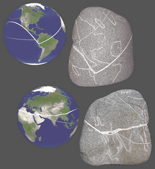
All of the main continents are depicted on the stone and for the most part they are shown in their correct locations and their correct relative sizes. How could anyone possibly know the geographic locations and sizes of all the worlds land masses that long ago?
restrictednews.com...
Something else that took me awhile to track down on the internet that goes along with the map...
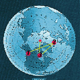
The causeway leading from the Great Pyramid runs about 15 degrees north of East. Allowing the location to represent 39 degrees latitude, the north pole would fall east of Greenland. Teotihuacan in Mexico City has its main causeway aligning about 15 degrees east of north. This points to the same location east of Greenland. Perhaps this was the north pole between 12,200 BC and 8100 BC. This would indicate that the north pole on the coast of Alaska, creating the ancient equator line with 10 equally spaced sites, was either between 20,000 BC and 12,200 BC or was prior to 20,200 BC before the beginning of this Great Cycle.
home.hiwaay.net...
If you look, there is a circle at the top of the stone map that COULD be interpreted as say.. an 'ancient arctic circle', with the center apparently in or near Alaska. COASTAL Alaska, even. . bear with me here.
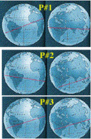
'1' on the view of the Arctic Circle corresponds to P1 on the next picture.
That would be the position of the old North Pole (1) and its corresponding equator. (P1)
That matches up PRETTY freakin succinctly with the ancient stone map! I keep finding more stuff on this (sorry for the edits, but I have to share and get all your guys informed feedback!).. Now continuing, the fainter line on the stone map representing the ancient equator, could the thicker line represent the path of seeding civilizations? Notice that it heads from Peru/Ecuador NORTH to Mexico, and then arcs around (sea travel is shorter by using the smaller areas of the globe vs traveling around its middle) to China, and then the line travels in a fairly straight path through the other ancient areas of civilization, India, the Middle East, and Egypt.
I.. am at a loss. This is so mindblowing!
How very interesting. That's not to say someone couldn't have scratched a rude map of the Earth into a rock and left it out in the middle of nowhere.. but apparently this rock was with a horde of other finds, including the so-called Black Pyramid.
There are several threads on here discussing various oopart's, but I haven't seen this one mentioned yet. If it's already been posted in a thread on ATS I apologize, but I searched stone maps and didn't come up with anything relative to THIS particular map.
A thread discussing various ooparts both debunked and still-in-question is here:
www.abovetopsecret.com...
The link at the top of this post was linked from another page here:
restrictednews.com...
I never know what to believe or not believe, so I choose to collect as much evidence as I can for either side... and keep collecting. I didn't see that the stone map itself had been tested by anyone for an actual verification of the ancient date ascribed to it, but . . who knows?
Supposedly it was amongst a large cache of finds in a tunnel in Ecuador back in 1984, along with the Black Pyramid and all the other stuff. My focus for THIS thread is primarily the map and the markings on it. Yes, it'd be very easy to say 'FAKE!!!!!' and move on, but.. what if it isn't!?
What if..
edit on 10-12-2012 by Fimbulvetr because: (no reason given)
Very interesting. At first I didn't see it, but the longer I looked the more uncanny it seemed.
If the article is correct, this could be yet another of the thousands of unexplained artifacts from around the world which seem to defy current understanding of technological development through history, eg. ancient batteries etc.
If the article is correct, this could be yet another of the thousands of unexplained artifacts from around the world which seem to defy current understanding of technological development through history, eg. ancient batteries etc.
Agreed.
Then I had the thought.. well, it COULD be a hoax. Then I thought, who would bury a hoax in a tunnel in Ecuador?
Then I thought, aha.. the team who found it because they WANTED to find some awesome ooparts.
Then I thought.. good lord, man. You sound like you're creating a conspiracy all your own about the discoverers.
So, either way I slice it.. Im stuck with a conspiracy.
a.) The people that 'found' it are lying and trying to cause a stir.
b.) It's real and is being left in the background of archaeology to keep us all in the dark about our true origins.
I just can't win either way!
edit on 10-12-2012 by Fimbulvetr because: (no reason given)
I always say this quote, "We never invent technologies on this earth. We just reinvent it."
reply to post by Fimbulvetr
Legitimacy of this 'artifact' aside, check out the Bermuda Triangle region.
Legitimacy of this 'artifact' aside, check out the Bermuda Triangle region.
reply to post by ProperlyErrant
If you read the article, there is a reference to that 'possibly' being a representation of a lost continent.
If you read the article, there is a reference to that 'possibly' being a representation of a lost continent.
reply to post by Fimbulvetr
It even depicts Atlantis off the coast of the Americas. Very interesting.
It even depicts Atlantis off the coast of the Americas. Very interesting.
Originally posted by LightAssassin
reply to post by Fimbulvetr
It even depicts Atlantis off the coast of the Americas. Very interesting.
I was just about to mention that but you beat me to the punch. I was going to speculate that it could be Atlantis.

Red = North America
Blue = South America
Black = Atlantis
Is this a real? For all I know this could be some rock a kid picked up and scratched with a key to make it look like an ancient stone map of our World. Would be really nice if this is real.
I saw these about a year ago. They are pretty cool. I believe they are from South America from a mine or some kind of underground something. No one
is allowed in and the government and military occupy the location (thats if this is the same place). Alot of things have been found with this
artifact. The other artifacts are pretty bizarre like the these two disk that show the growth of a human being from womb to adulthood and this other
disk that is the same in nature but it has these unknown creatures/humanoids with big eyes. Its pretty crazy. The guy mentioned atlantis in the
youtube video I saw as well.
Good post.
Good post.
reply to post by AKINOFTHEFIRSSTARS
That sounds familiar. Could you find it again? I'd like to take another look myself.
Thanks....
That sounds familiar. Could you find it again? I'd like to take another look myself.
Thanks....
reply to post by Fimbulvetr
You should all look up Klaus Dona's presentations of old artifacts. I guarantee you will be amazed! Good thread! Here is a treat for you!
He has information about this world stone map too.
You should all look up Klaus Dona's presentations of old artifacts. I guarantee you will be amazed! Good thread! Here is a treat for you!
He has information about this world stone map too.
edit on 10-12-2012 by OnWhiteMars because: (no reason given)
edit on 10-12-2012 by OnWhiteMars
because: (no reason given)
I do believe I saw that on the other thread that I linked in the OP..
However I did just do an edit to the OP concerning the circle on the stone (and globe picture) that may or may not be a representation of the magnetic and/or polar north at the time of the map.
Had to scramble all over the net to find something that would reference an Alaskan 'North', but there is a link to the site that says just that!!
Originally posted by AKINOFTHEFIRSSTARS
I saw these about a year ago. They are pretty cool. I believe they are from South America from a mine or some kind of underground something. No one is allowed in and the government and military occupy the location (thats if this is the same place). Alot of things have been found with this artifact. The other artifacts are pretty bizarre like the these two disk that show the growth of a human being from womb to adulthood and this other disk that is the same in nature but it has these unknown creatures/humanoids with big eyes. Its pretty crazy. The guy mentioned atlantis in the youtube video I saw as well.
Good post.
I think you are talking about Klaus Dona's presentations. All the things mentioned by you are in his vids.
Very cool.
I'm very skeptical of the authenticity, particularly the estimated date of origin. It seems as if this has only been reported by fringe sources.
At face value, the assumption is probably that there must have been a civilization or group with knowledge of the globe 12,000 years ago, and they must have circumnavigated to draw so accurately.
I'm thinking to myself, is it possible at all that such a map could be extrapolated from nature without ever leaving one's locality? We don't know of any such method now, but the fact that the Earth is spehrical could easily be deduced... maybe there was just such a genius that in observing and hearing accounts of the geology on their own continent, they may be able to deduce the coastlines of the world.
If there were a plate tectonics savant, who had intricate knowledge of the South American geology, I imagine it may be possible.
An analogy might be the way we have deduced the spiral structure of our galaxy.
But, in my opinion, the more likely explanations would be hoax or lost civilization...just thought I'd share that interesting bit that crossed my mind.
ETA: Thought I'd also point out that the number of fake artifacts vastly outnumbers real.
edit on 12/10/2012 by PatrickGarrow17 because: (no
reason given)
Supposing it was a map of the world I don't think that the area off the N. American atlantic is Atlantis, but probably the Caribbean. I would say
this because of the same circle type entry off the S. American Pacific, the Japanese Islands being a single thing, and it looks like the Malay
Archipelago is incorporated into SE Asia proper. For an ancient cartographer, without specifics on proportionality, lumping island chains together as
an indication of "land masses" would make sense.
Also, notice that it is a rough approximation of only the Northern Hemisphere. The equator is a little southern than it really is, but it is pretty close.
Whoever did this did not originate from Europe. Before the 1st Century since ancient Eurasian maps had an "East is Up" orientation until Ptolemy adopted a "north up" standard in the 1st Century. There was a brief Medeval regression to the "East is Up" (where we get the word "orientation" from), so that would take out vikings and Basques (they were the second European group the find North America).
From what I understand of Mayan Cartography, they presented a circular orientation of the world (think Polar Coordinate Projection).
So who could this information be from? The Chinese. This stone looks a lot like a Chinese map from the 15th Century, about 60 years before Columbus showed up to North America. If one of the Chinese wrecked in Central America on one of the earlier voyages and transcribed the data it would look a lot like this with one exception: this is northern hemisphere only and the Chinese had a good understanding of the equator.
reply to post by Fimbulvetr
I've seen this stone a few times over the years and it's story in various incarnations. I've never really knew how to take it. Klaus D. has presented some interesting related stuff. AS always I try to keep an open mind though.
To be honest I'm leaning towards an interesting Hoax.
But as always one just never knows for sure.
S & F
For an interesting and well put together thread.
reply to post by Fimbulvetr
Ancient aliens comes to mind when i wonder who helped them map out the world, Great find thread op
Ancient aliens comes to mind when i wonder who helped them map out the world, Great find thread op
reply to post by Fimbulvetr
Features of the Earth on those stones are unmistakable. Obviously from the time the land masses were a bit different.
If it's not a hoax, one thing that puzzles me about this discovery (I have seen it before), is: So whoever it was, had way more knowledge and obviously circumvented the earth. But why would you engrave such a map on some irregularly shaped stone? And you were obviously tech advanced, or at least you posses knowledge.
If the thing is real...I think it's human attempt to redraw from an older source (a map of some kind).
If there was a cataclizmic event in the past that wiped out the majority of the population, I could see this crude "earth" model being used as a learning tool for children of the survivors...sort of legacy knowledge. Perhaps it was a globe toy much the same we have today. Just a little bit of daydreaming
reply to post by Fimbulvetr
Great thread.
Some interesting info, especially with the map including what could be Atlantis like others have mentioned.
Also bookmarked for the vids OnWhiteMars linked.
Great thread.
Some interesting info, especially with the map including what could be Atlantis like others have mentioned.
Also bookmarked for the vids OnWhiteMars linked.
Terrific find!
In my opinion this map would coincide with the seeding of civilization through Noah after the destruction of the Tower of Babel and the scattering of mankind.
I am facinated to see both the location of the Equator/north pole at that moment in time, and the existance of Atlantis at the time. Seeing the N/S/E/W orientation line up with ancient monuments under this new allignment is awesome to see.
Thank you so much for this thread.
God Bless,
new topics
-
President BIDEN's FBI Raided Donald Trump's Florida Home for OBAMA-NORTH KOREA Documents.
Political Conspiracies: 48 minutes ago -
Maestro Benedetto
Literature: 2 hours ago -
Is AI Better Than the Hollywood Elite?
Movies: 2 hours ago -
Las Vegas UFO Spotting Teen Traumatized by Demon Creature in Backyard
Aliens and UFOs: 5 hours ago -
2024 Pigeon Forge Rod Run - On the Strip (Video made for you)
Automotive Discussion: 6 hours ago -
Gaza Terrorists Attack US Humanitarian Pier During Construction
Middle East Issues: 7 hours ago -
The functionality of boldening and italics is clunky and no post char limit warning?
ATS Freshman's Forum: 8 hours ago -
Meadows, Giuliani Among 11 Indicted in Arizona in Latest 2020 Election Subversion Case
Mainstream News: 8 hours ago -
Massachusetts Drag Queen Leads Young Kids in Free Palestine Chant
Social Issues and Civil Unrest: 9 hours ago -
Weinstein's conviction overturned
Mainstream News: 10 hours ago
top topics
-
Krystalnacht on today's most elite Universities?
Social Issues and Civil Unrest: 12 hours ago, 9 flags -
University of Texas Instantly Shuts Down Anti Israel Protests
Education and Media: 14 hours ago, 8 flags -
Supreme Court Oral Arguments 4.25.2024 - Are PRESIDENTS IMMUNE From Later Being Prosecuted.
Above Politics: 11 hours ago, 8 flags -
Gaza Terrorists Attack US Humanitarian Pier During Construction
Middle East Issues: 7 hours ago, 7 flags -
Weinstein's conviction overturned
Mainstream News: 10 hours ago, 7 flags -
Massachusetts Drag Queen Leads Young Kids in Free Palestine Chant
Social Issues and Civil Unrest: 9 hours ago, 7 flags -
President BIDEN's FBI Raided Donald Trump's Florida Home for OBAMA-NORTH KOREA Documents.
Political Conspiracies: 48 minutes ago, 6 flags -
Meadows, Giuliani Among 11 Indicted in Arizona in Latest 2020 Election Subversion Case
Mainstream News: 8 hours ago, 5 flags -
Las Vegas UFO Spotting Teen Traumatized by Demon Creature in Backyard
Aliens and UFOs: 5 hours ago, 4 flags -
Chris Christie Wishes Death Upon Trump and Ramaswamy
Politicians & People: 12 hours ago, 2 flags
active topics
-
HORRIBLE !! Russian Soldier Drinking Own Urine To Survive In Battle
World War Three • 45 • : Xtrozero -
Supreme Court Oral Arguments 4.25.2024 - Are PRESIDENTS IMMUNE From Later Being Prosecuted.
Above Politics • 80 • : WeMustCare -
University of Texas Instantly Shuts Down Anti Israel Protests
Education and Media • 242 • : cherokeetroy -
Massachusetts Drag Queen Leads Young Kids in Free Palestine Chant
Social Issues and Civil Unrest • 12 • : SchrodingersRat -
SETI chief says US has no evidence for alien technology. 'And we never have'
Aliens and UFOs • 73 • : SchrodingersRat -
Is AI Better Than the Hollywood Elite?
Movies • 5 • : 5thHead -
New whistleblower Jason Sands speaks on Twitter Spaces last night.
Aliens and UFOs • 62 • : pianopraze -
Alternate Electors vs Fake Electors - What is the Difference.
2024 Elections • 115 • : WeMustCare -
Sunak spinning the sickness figures
Other Current Events • 24 • : NoCorruptionAllowed -
Nearly 70% Of Americans Want Talks To End War In Ukraine
Political Issues • 95 • : Irishhaf