It looks like you're using an Ad Blocker.
Please white-list or disable AboveTopSecret.com in your ad-blocking tool.
Thank you.
Some features of ATS will be disabled while you continue to use an ad-blocker.

Cracking an eggshell? II
page: 1share:
Some time back, I posted a thread entitled Cracking an eggshell? that addressed the
rumblings going on along the New Madrid/St. Lawrence fault lines. But the recent rumblings
along Canada's West Coast have provoked me to focus my attention on a different area.
In that older thread, I showed the pressure directions as shown in this original picture:
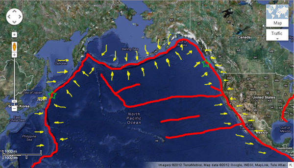
As you can see, the pressure lines run from east to west across the North American continent. Now I want to focus on the Pacific Basin, at least the northern half of it:
This is another image I made along the same lines showing the Pacific Basin. The Fukushima quake and the Vancouver quake are shown with green stars, the fault lines are shown in red, and the pressure directions (approximate since I don't have perfectly steady hands) are shown in yellow. What caught my eye was the bulge along the Bering Island Chain... indicative of a flow. Rocks do flow under pressure, even if they are 'solid'. The bulge is the result of the interaction of the Asian Plate and the North American Plate pressing toward each other. The rock has to go somewhere, so it begins to flow southward like an extremely viscous liquid. This in turn transmutes the east-west forces into a southerly force that is pressing against the northern edge of the Pacific Basin.
This puts pressure on the northern part of the Pacific Plate. Notice how smooth the upper part of that plate is compared to around the California/Hawaii area. Off the coast of California, the plate is cracked and fractured, while north of California it is more solid and unbroken. Rocks come in all different hardnesses and brittleness, so this is not really unexpected, but it does indicate a unique situation in this area. Both the Fukushima and Vancouver quakes were the result of plates building stress against a relatively hard Pacific Plate section. Compare that to California, with smaller but more frequent rumblings, the result of a more easily deformed area of the Pacific Basin.
What does this hold for the future? Well, simply put, the stresses are shifting. The Vancouver quake released energy in that area; that will in turn apply pressure to the cracked area below it (California). this pressure can release in one of three ways:
There are other considerations. The New Madrid will now have pressure increased from the West, as the pressures from California are transmitted throughout the crust. This increases the likelihood of a slip, and a slip of enough intensity would break the Midwest tie I mentioned in the earlier thread. That means be on the lookout for those tell-tale shakes along the Illinois/Indiana region. Tremors north or south (Quebec, Arkansas) could be precursors to this.
Also, this would result in a pressure shift on Yellowstone. While I could not suggest a result of the New Madrid situation on Yellowstone, I do believe this would result in either a reduction of pressure keeping Yellowstone in check, or a sideways pressure that could easily open a fissure in the area. No, the planet is not going to crack apart, but even a small fissure (crack) could lead to some fireworks in the area.
In short, I suggest anyone interested in this line of thought be on the lookout for the following:
TheRedneck
In that older thread, I showed the pressure directions as shown in this original picture:

As you can see, the pressure lines run from east to west across the North American continent. Now I want to focus on the Pacific Basin, at least the northern half of it:
This is another image I made along the same lines showing the Pacific Basin. The Fukushima quake and the Vancouver quake are shown with green stars, the fault lines are shown in red, and the pressure directions (approximate since I don't have perfectly steady hands) are shown in yellow. What caught my eye was the bulge along the Bering Island Chain... indicative of a flow. Rocks do flow under pressure, even if they are 'solid'. The bulge is the result of the interaction of the Asian Plate and the North American Plate pressing toward each other. The rock has to go somewhere, so it begins to flow southward like an extremely viscous liquid. This in turn transmutes the east-west forces into a southerly force that is pressing against the northern edge of the Pacific Basin.
This puts pressure on the northern part of the Pacific Plate. Notice how smooth the upper part of that plate is compared to around the California/Hawaii area. Off the coast of California, the plate is cracked and fractured, while north of California it is more solid and unbroken. Rocks come in all different hardnesses and brittleness, so this is not really unexpected, but it does indicate a unique situation in this area. Both the Fukushima and Vancouver quakes were the result of plates building stress against a relatively hard Pacific Plate section. Compare that to California, with smaller but more frequent rumblings, the result of a more easily deformed area of the Pacific Basin.
What does this hold for the future? Well, simply put, the stresses are shifting. The Vancouver quake released energy in that area; that will in turn apply pressure to the cracked area below it (California). this pressure can release in one of three ways:
- The rock can deform to accept it.
Unlikely, since the broken faults extending from California into the Pacific indicate this rock is not very good at deforming, since it is brittle and
therefore much better at cracking.
- There will be an increase in quakes along California. This one is quite probable, as the rock adjusts to its new force equilibrium. It is also
desirable, because the third option is much worse.
- The increased pressure on the California coast will decrease the number of small-medium quakes in the coming months. This is the scariest
possibility, because it means pressures will begin to build instead of being released regularly. Building pressures will create larger quakes as the
rock finally slips, and o course there is no way to know i the rock, as brittle and cracked as it is, will simply slip suddenly and tragically, or
will literally crumble away.
Crumbling away is a bad thing. Trust me on this.
There are other considerations. The New Madrid will now have pressure increased from the West, as the pressures from California are transmitted throughout the crust. This increases the likelihood of a slip, and a slip of enough intensity would break the Midwest tie I mentioned in the earlier thread. That means be on the lookout for those tell-tale shakes along the Illinois/Indiana region. Tremors north or south (Quebec, Arkansas) could be precursors to this.
Also, this would result in a pressure shift on Yellowstone. While I could not suggest a result of the New Madrid situation on Yellowstone, I do believe this would result in either a reduction of pressure keeping Yellowstone in check, or a sideways pressure that could easily open a fissure in the area. No, the planet is not going to crack apart, but even a small fissure (crack) could lead to some fireworks in the area.
In short, I suggest anyone interested in this line of thought be on the lookout for the following:
- Small earthquakes in the Midwest from New
Madrid to Chicago.
- Changes in the Yellowstone cauldera.
- Either increased or decreased activity in California. Increased=good, decreased=worry.
TheRedneck
Thank you for a post that is both well thought out and well presented. S&F to you.
What you describe could easily be the start of one or both of the two worst disasters facing the lower half of the North American continent. While there is a possibility of a mega quake along the Washington coast and extending into southern Canada (the Cascadia subduction zone) and/or a disaster connected to the B P oil well fiasco in the gulf (and possibly including the Louisiana sink hole) they would pale by comparison to a total fracture of the New Madrid fault which would leave America split in two by an inland sea and/or a total eruption of Yellowstone. Either one of which would spell the end of life as we know it and the beginning of a new dark age.
What you describe could easily be the start of one or both of the two worst disasters facing the lower half of the North American continent. While there is a possibility of a mega quake along the Washington coast and extending into southern Canada (the Cascadia subduction zone) and/or a disaster connected to the B P oil well fiasco in the gulf (and possibly including the Louisiana sink hole) they would pale by comparison to a total fracture of the New Madrid fault which would leave America split in two by an inland sea and/or a total eruption of Yellowstone. Either one of which would spell the end of life as we know it and the beginning of a new dark age.
Wow! You present some scary information indeed...but it makes a lot of sense.
You mention California, but I am wondering what your thoughts are regarding the area between yesterdays quake and California. What, in your opinion has all of this stress done to the Juan de Fuca plate?
Thanks in advance, and thank you for this thread.
Peace
You mention California, but I am wondering what your thoughts are regarding the area between yesterdays quake and California. What, in your opinion has all of this stress done to the Juan de Fuca plate?
Thanks in advance, and thank you for this thread.
Peace
Crumbling away is a bad thing. Trust me on this.
The crust can crack and shift to a certain point, but it also can be reformed by the process of subduction, were the crust is forced down into the mantle, melted and used to reinforce or create tectonic plates.
Of course this takes millions of years.
Thank you for the illustration
edit on 28-10-2012 by MDDoxs because: (no reason given)
reply to post by lasertaglover
That all depends on how much pressure this quake released and how much pressure there was to begin with, as well as how ductile (able to bend and flow) the Pacific Basin Plate is.
I really don't see much change overall to the area north of California. There could be further subduction events away from Vancouver Island, and there could still be another quake waiting to happen there. I have heard more than one person suggest this could be a foreshock, but it is just speculation at this point.
One interesting point I forgot to cover: notice at the Fukushima site, there is a 'corner' in the plates. This indicates an area of relatively lower ductility and thus a pressure point. That's why that region is subject to such massive quakes: all the pressure is intensified in that corner where the plates cannot easily move against each other. When it does slip, it slips hard!
On the other side at Vancouver, there is no such 'corner' and thus no single intensity point. The slippage has apparently been much more uniform, and thus it is much harder to tell where and if another large slip is in the future.
The real dangers from this latest quake are not near the quake site. They are where the forces have been destabilized. The reason I pointed out California was because of that transition between solid and broken seafloor.
TheRedneck
reply to post by TheRedneck
I appreciate the answer especially because I have a number of friends in that region. However, the pressures being put on those other points you mention definitely warrant close observation.
Personally, I believe that something big is on the horizon for a number of reasons.
Thank you again for putting all of this together and I am looking forward to the information that will come out of this thread.
Peace
Very informative! ...as you always are
I'm wondering if the Canada quakes are just leading up to a New Madrid one? Kind of like the "edges building up" and working their way in to the NewMadrid fault?
I remember the one back in 1980 and don't want to experience that again!
I'm wondering if the Canada quakes are just leading up to a New Madrid one? Kind of like the "edges building up" and working their way in to the NewMadrid fault?
I remember the one back in 1980 and don't want to experience that again!
I'm not an expert or close to one. But doesn't the San Andres Fault move basically north (western side)/south (eastern side) or up and down..?
San Andres Fault via Wiki
Then wouldn't that move the pressure points along the western US?
The Gorda Plate is being rotated (clock wise) by the movement from the San Andres right? Which puts pressure on the Juan DeFuca plate and northward again puts pressure on the Explorer plate.
I complete lost where I was going with this, It was not to look/sound negative or "flaming" or cause flaming in any means..
Isaac (If I remember where I was going, I will post a reply)..
Congratulations, you have discovered plate tectonics. But anyone with any sense will surely realize that while scientists have gained much more
knowledge about how earthquakes occur, the instrumentation needed to actually predict a quake with any accuracy does not exist, and certainly is not
in place.
So, you can draw red lines all over Google maps, but it is nothing more than a guess, and a not very educated one at that. The simple truth is that the earth is still far too complex a system for us to understand and model correctly. That is why earthquakes still catch nearly everyone by suprise. And they will continue to do so for the next 100-200 years.
So, you can draw red lines all over Google maps, but it is nothing more than a guess, and a not very educated one at that. The simple truth is that the earth is still far too complex a system for us to understand and model correctly. That is why earthquakes still catch nearly everyone by suprise. And they will continue to do so for the next 100-200 years.
I will add that not all plates are pushing into each other, some sections slide past each other.
edit on 29-10-2012 by bigrex because: (no
reason given)
Interesting writeup. I think it's also worthy of note that the "main" San Andreas Fault (as it's a system and not just one) actually extends out
into the sea and almost meets up with the southern part of the CSZ at the Mendocino Triple Junction (the MTJ -- a boundary of the Gorda Plate).
Viz:
From: A Woods Hole/ USGS article entitled Mendocino Triple Junction Offshore Northern California
The problem as I see it is that if the CSZ lets go in a big way (along the Juan de Fuca/Nth America plate boundary, meaning as well as down to the MTJ and Gorda plate), then as part of the energy release and movement involved, there could be a pressure release in the region of that junction, which paradoxically could allow more slip along the SAF. This, combined with the violent movment associated with a ~Mag 9 subduction event could perhaps result in a domino effect and allow quakes to occur some distance to the SE along the SAF system.
Meanwhile, there is the other issue of major subduction in the PNW, namely that such an event could be enough to trigger or increase volcanic activity in the Cascades. And, as you mentioned, there might even be knock-on effects in Yellowstone, although it has to be pointed out that as YS has not had a major eruption in many thousands of years, none of the subduction events (evidenced by turbidite deposits) on the CSZ in the past several thousand years seem to have had a great deal of effect on the supervolcano.
Frankly I don't know if anyone has been able to directly link CSZ/SAF events with the New Madrid Seismic Zone (NMSZ). In a sense, everything is connected, but exactly how a large event in the CSZ/SAF region could trigger major activity in the NMSZ is hard to determine. Granted, there could be a time lag between the two: the last great quake on the CSZ was in 1700, and just over a century later in 1811-12 there was the series of major quakes in the NMSZ. A hundred years or so is an eyeblink, geologically speaking.
However, in that scenario, even if a major subduction event were to occur on the CSZ this afternoon, then it might not have any serious knock-on effects in the NMSZ for decades or more. But meanwhile, the other possible causative mechanisms for the 1811-12 quakes are still not well understood, because such events typically don't occur mid-plate. This is why some researchers are leaning towards the idea that the Nth America plate is not one big plate, but possibly two sections, with the middle line roughly following the Mississippi. That would actually make some sense as it would also help to explain why that river runs so remarkably N>S for such a long way.
Anyway enough from me for now. I'm still nervously keeping an eye on the PNW as that is the most troubling seismic zone in Nth America in some respects: the SAF is pretty well known among the general public in the region, the NMSZ is not so well known to those who live within it, and frankly the CSZ's potential threat is probably only recognize by a very small percentage of those who are living there. Only a low percentage even have quake insurance on their homes. And that's a worry.
Mike
Viz:
The San Andreas fault marks the principal Pacific-North America plate boundary south of the MTJ. The SAF last ruptured in the 1906 M7.7 quake and geophysical evidence indicates that rupture extended within a few 10s of km south of the MTJ.
From: A Woods Hole/ USGS article entitled Mendocino Triple Junction Offshore Northern California
The problem as I see it is that if the CSZ lets go in a big way (along the Juan de Fuca/Nth America plate boundary, meaning as well as down to the MTJ and Gorda plate), then as part of the energy release and movement involved, there could be a pressure release in the region of that junction, which paradoxically could allow more slip along the SAF. This, combined with the violent movment associated with a ~Mag 9 subduction event could perhaps result in a domino effect and allow quakes to occur some distance to the SE along the SAF system.
Meanwhile, there is the other issue of major subduction in the PNW, namely that such an event could be enough to trigger or increase volcanic activity in the Cascades. And, as you mentioned, there might even be knock-on effects in Yellowstone, although it has to be pointed out that as YS has not had a major eruption in many thousands of years, none of the subduction events (evidenced by turbidite deposits) on the CSZ in the past several thousand years seem to have had a great deal of effect on the supervolcano.
Frankly I don't know if anyone has been able to directly link CSZ/SAF events with the New Madrid Seismic Zone (NMSZ). In a sense, everything is connected, but exactly how a large event in the CSZ/SAF region could trigger major activity in the NMSZ is hard to determine. Granted, there could be a time lag between the two: the last great quake on the CSZ was in 1700, and just over a century later in 1811-12 there was the series of major quakes in the NMSZ. A hundred years or so is an eyeblink, geologically speaking.
However, in that scenario, even if a major subduction event were to occur on the CSZ this afternoon, then it might not have any serious knock-on effects in the NMSZ for decades or more. But meanwhile, the other possible causative mechanisms for the 1811-12 quakes are still not well understood, because such events typically don't occur mid-plate. This is why some researchers are leaning towards the idea that the Nth America plate is not one big plate, but possibly two sections, with the middle line roughly following the Mississippi. That would actually make some sense as it would also help to explain why that river runs so remarkably N>S for such a long way.
Anyway enough from me for now. I'm still nervously keeping an eye on the PNW as that is the most troubling seismic zone in Nth America in some respects: the SAF is pretty well known among the general public in the region, the NMSZ is not so well known to those who live within it, and frankly the CSZ's potential threat is probably only recognize by a very small percentage of those who are living there. Only a low percentage even have quake insurance on their homes. And that's a worry.
Mike
edit on 29/10/12 by JustMike because: I fixed a spelling error. As for any others, you may mentally correct them yourselves. ;
reply to post by PurpleChiten
That was basically my point... the release in Vancouver should increase pressure along the California coast, which would induce a moment in the North American plate. That would increase the shear pressure along the New Madrid system.
Of course, as someone pointed out, this is an extremely complex system, composing a practically unlimited number of independent equations, each of them containing several unknown variables. I can say "pressure should have increased/decreased in this area," but not "an earthquake will happen here." It's all still a guess, albeit an educated guess.
TheRedneck
reply to post by Isaac (RIP DUSTIN)
The Juan de Fuca and the Gorda plate will introduce some instability as the pressures shift, but to be honest I have no idea what kind of instability. At this time I have to simply consider them a local anomaly doing little more than introducing a certain amount of uncertainty in their local area.
TheRedneck
The new madrid just released something this morning. 3.9 In Arkansas
The house was rolling for about 10 seconds vicinity of memphis.
Here's the usgs link earthquake.usgs.gov...
The house was rolling for about 10 seconds vicinity of memphis.
Here's the usgs link earthquake.usgs.gov...
reply to post by TuMadreTambien
Congratulations, you just discovered engineering.
One of the things advanced mathematics allows us to do is to make conclusions about linear systems we do not have all the variables for. It may not be completely accurate, but it is useful.
TheRedneck
Congratulations, you just discovered engineering.
One of the things advanced mathematics allows us to do is to make conclusions about linear systems we do not have all the variables for. It may not be completely accurate, but it is useful.
TheRedneck
reply to post by JustMike
If there are more slips along the Canadian/northern US coast, that will only intensify the effects. I am interested as well as to the actual reaction along the smaller plates.
I know you seem to have had a 'sense' for these things in the past... do you still feel something is yet to come north of California?
TheRedneck
reply to post by InherentDistrust
Also just had a 3.0 in Hawaii. Looking at the USGS map, it does look like an arc of shakes extend back to the New Madrid as well.
TheRedneck
Also just had a 3.0 in Hawaii. Looking at the USGS map, it does look like an arc of shakes extend back to the New Madrid as well.
TheRedneck
Originally posted by TuMadreTambien
Congratulations, you have discovered plate tectonics. But anyone with any sense will surely realize that while scientists have gained much more knowledge about how earthquakes occur, the instrumentation needed to actually predict a quake with any accuracy does not exist, and certainly is not in place.
So, you can draw red lines all over Google maps, but it is nothing more than a guess, and a not very educated one at that. The simple truth is that the earth is still far too complex a system for us to understand and model correctly. That is why earthquakes still catch nearly everyone by suprise. And they will continue to do so for the next 100-200 years.
Your post is interesting, but its far from the truth. The Earth's crust does crack and move as in the Theory of Plate Tectonics, but large earthquakes do strike in areas where there is apparently no plate boundary, and also there are volcanoes where there are no plate boundaries (those are the flaws of plate tectonics); meaning a new theory or a correction to the theory is needed to be made.
The instrumentation needed to predict any near surface earthquake has existed since 1995 (piezoseismology, www.youtube.com...).
With piezoseismology the chain reaction of earthquakes can be seen as it takes place. This is simple, because many times an earthquake strikes in the distance and the force suddenly becomes detectable and measurable in other areas afterwards; so the Earth can be modeled with extreme accuracy.
The reasons why earthquakes take people by surprise is because no one knows about piezoseismology, even though its been around since 1995. Also, everyone believes the crap seismologists tell them about earthquakes. Finally the Italians have stood up to this BS spread by seismologists and their scientific seismology "beliefs". Those seismology beliefs have been used by seismologists to keep their jobs. Its good to see the Italians aren't going to take any more crap off of seismologists that are only experts in telling your where to send an ambulance; these ambulance chasers will soon be thinned out.
Piezosiesmology is going to blossom soon onto the world scene as the only scientific method to accurately map earthquakes of all magnitudes before they strike, pinpoint their depth, determine their magnitude, and show the fault line as it strikes across the countryside (all before the earthquakes strike).
As an expert... I debunked your post in its entirety, with "real" science; not stupid seismology beliefs.
Originally posted by TheRedneck
reply to post by JustMike
[snip]
I know you seem to have had a 'sense' for these things in the past... do you still feel something is yet to come north of California?
TheRedneck
Crumbs, that's quite a question!
I know you asked about what is basically the Pacific Northwest, especially OR up through WA and into BC, but first I'd like to address Nth CA, because of its complexity and possible importance.
To begin with I'll mention something that you doubtless know but some of our readers might not. Namely, although Nth Cal is not as seismically “busy” as the south, they get a fair number of quakes. Most of them are small – especially the on-land ones. The larger ones tend to occur in the sub-sea plate regions. (More on that in a minute.)
What is interesting about Nth Cal is the various interactions there. The subducting Gorda plate can cause quakes on land, but if it does they'd tend to be deeper than the sub-sea events and generally would also be at lower energy levels. But there is also the Juan de Fuca plate, which on a typical map is shown with its deformation front some miles off land:
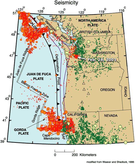
(Map from Geomaps via USGS at this link)
However, while that is the main front and we'd expect the hypocenter/s of any major subduction event to be close to it, the subducted plate itself extends some miles inland, going deeper down further away (to the E) from the deformation front. The interactive Tremor map from the Pacific Northwest Seismic Network (here) shows the subducted plate at various depths:
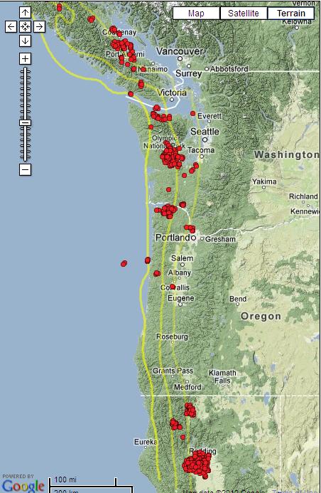
Yes, all those red dots are epicenters for tremors – just for yesterday! These quakes are so small that they are almost never felt, but each one indicates some movement going on. (By the way this is not an unusual number to see in one day. It varies, though.)
Anyway, the yellow lines in the above image show the plate's assumed subducted depth at 20, 30 and 40 km. For example, the line that passes closest to Portland indicates the subducted plate is about 40 km down; off the coast from there, the first yellow line shows a depth of 20 km.
So, we can see that things are rather complicated. There are four plates active in or close to Nth Cal – the Pacific, the Nth American and the Juan de Fuca – and sandwiched in among all that, the Gorda. And two of them – the Juan de F. and the Gorda – are subducting beneath the Nth American plate. Then when we add the San Andreas fault into the mix and also possible effects of localized volcanic activity, it's one heck of a puzzle!
Now onto those places nth of CA. I observe the PNW region more often and more closely than just about any other place on the globe, because it is the one (in the US and BC) that not only can cause devastation over an enormous area, but has the possibility of a major tsunami as well.
As I mentioned elsewhere I've been uneasy for several days and that mag 7.7 not far north of Vancouver Island did little to help. The only reassuring fact I can point to is yesterday's quake was the biggest in that region since 1949, when they had a mag 8.1. And even after that, the CSZ did not let go with its potential mag 9 quake.
Vancouver and Seattle and the coastal region there, to 600 miles or more down the coast is the worry. But Nth Cal could tie in as an indicator. If there is a major increase in quake activity there, that might mean that things are on the move and the Juan de Fuca could be ready for a big subduction event. That is one of the things I'm looking out for: an increase in activity at either end of the plate. Such activity on land, at depths down to about 40 km, would be very concerning indeed. Odd as it seems, really shallow quakes would probably be less of a worry.
Significant quakes at sea near the deformation boundary are also a concern, especially if land-based ones at the “right” (subducted plate) depths follow shortly after. That's what I'm watching for now and hoping not to see.
Not an ideal answer, I know, but the best I can do for now. In short, lots of smaller quakes along that inland subduction line, especially if not near known, shallow faults, could be a strong indicator. Big quakes on the main boundary are always a concern, but the little ones can be very significant as well.
EDIT: with a large quake within a subduction zone, there is the concern that it's a foreshock to a larger one. This was the case in Japan, when the mag 7.3 on March 9 was followed by the mag 9.0 on March 11. And the big quake occurred only fractions of a degree of lat. and long. from the foreshock. So that's why I'm nervous about the mag 7.7 on Oct 28 (UTC time). The 1949 event showed that a megaquake doesn't have to follow, but all the same if I lived in the region I'd be wary. Not panicked, just wary.
Mike
edit on 29/10/12 by JustMike because: (no reason given)
new topics
-
A Warning to America: 25 Ways the US is Being Destroyed
New World Order: 2 hours ago -
President BIDEN's FBI Raided Donald Trump's Florida Home for OBAMA-NORTH KOREA Documents.
Political Conspiracies: 8 hours ago -
Maestro Benedetto
Literature: 10 hours ago -
Is AI Better Than the Hollywood Elite?
Movies: 10 hours ago
top topics
-
President BIDEN's FBI Raided Donald Trump's Florida Home for OBAMA-NORTH KOREA Documents.
Political Conspiracies: 8 hours ago, 28 flags -
Gaza Terrorists Attack US Humanitarian Pier During Construction
Middle East Issues: 15 hours ago, 8 flags -
Massachusetts Drag Queen Leads Young Kids in Free Palestine Chant
Social Issues and Civil Unrest: 17 hours ago, 7 flags -
Las Vegas UFO Spotting Teen Traumatized by Demon Creature in Backyard
Aliens and UFOs: 13 hours ago, 6 flags -
A Warning to America: 25 Ways the US is Being Destroyed
New World Order: 2 hours ago, 6 flags -
Meadows, Giuliani Among 11 Indicted in Arizona in Latest 2020 Election Subversion Case
Mainstream News: 16 hours ago, 5 flags -
2024 Pigeon Forge Rod Run - On the Strip (Video made for you)
Automotive Discussion: 14 hours ago, 4 flags -
Is AI Better Than the Hollywood Elite?
Movies: 10 hours ago, 3 flags -
The functionality of boldening and italics is clunky and no post char limit warning?
ATS Freshman's Forum: 16 hours ago, 1 flags -
Maestro Benedetto
Literature: 10 hours ago, 1 flags
active topics
-
A Warning to America: 25 Ways the US is Being Destroyed
New World Order • 2 • : Disgusted123 -
President BIDEN's FBI Raided Donald Trump's Florida Home for OBAMA-NORTH KOREA Documents.
Political Conspiracies • 19 • : ADVISOR -
When an Angel gets his or her wings
Religion, Faith, And Theology • 22 • : AcrobaticDreams1 -
King Charles 111 Diagnosed with Cancer
Mainstream News • 321 • : FlyersFan -
Is there a hole at the North Pole?
ATS Skunk Works • 41 • : burritocat -
Massachusetts Drag Queen Leads Young Kids in Free Palestine Chant
Social Issues and Civil Unrest • 16 • : FlyersFan -
Gaza Terrorists Attack US Humanitarian Pier During Construction
Middle East Issues • 33 • : FlyersFan -
Weinstein's conviction overturned
Mainstream News • 24 • : burritocat -
-@TH3WH17ERABB17- -Q- ---TIME TO SHOW THE WORLD--- -Part- --44--
Dissecting Disinformation • 690 • : burritocat -
University of Texas Instantly Shuts Down Anti Israel Protests
Education and Media • 266 • : SchrodingersRat