It looks like you're using an Ad Blocker.
Please white-list or disable AboveTopSecret.com in your ad-blocking tool.
Thank you.
Some features of ATS will be disabled while you continue to use an ad-blocker.

Cracking an eggshell?
page: 1share:
OK, this is probably going to be controversial, and I am probably going to end up looking silly, but I feel the need to get it out in the public
eye... so here goes. ATS is the most open forum to possibilities on the Internet.
Many of you know me. I am not a geology guru, but I am pretty good in the engineering disciplines. When I look at a map of the globe, I see forces and counter-forces. I recently was looking over this thread concerning a small but unusual earthquake in northern central Indiana and remembered a prediction I had quietly made to myself a few months ago. I actually was concerned about an earthquake happening in this area.
Now obviously, I didn't record that prediction, so I am going over this from square one. It starts with the recent BP Gulf Oil disaster.
This is a map I pulled up from Google Maps, on which I superimposed the plate boundaries/faults in red, the forces acting on/from these faults in yellow, and the location of the BP well in green (I don't have Photoshop on this machine, it's still too cold to go to the shop, so forgive my poor skills with inferior software):
The Pacific plate we are all pretty familiar with. It is exerting a small pressure on the American West Coast up to Alaska. There is a small sideways fault in it that ends in northern California, evidence that the tectonic movement is changing either speed or direction along that line. Based on the shape of the Pacific Plate where it interacts with Alaska, I would expect a directional shift northward north of that line and due east south of it.
The small Central American Plate is also pretty familiar to anyone who has looked at fault lines. It appears to me to be pretty dense and immobile, causing islands to pile up around its edge. That would explain why it broke loose into its own plate.
Of course, to the right you will see the Mid-Atlantic Rift, where the plates are pulling apart from each other. What initially got my interest was the shift just east of the St. Lawrence Bay... it looks as though here again, the plate is cracked but this time by a speed shift... as though the plate to the south is moving faster than the one to the north. If you follow this geographic feature, it aligns perfectly with the St. Lawrence River, which is itself something a bit unusual simply due to its size... the river is huge, almost like a gash that happens to be filled with water. Follow this river down and it ends in the Great Lakes, Lake Erie to be precise, and seems to disappear.
Now look at the New Madrid Fault. It extends down the Mississippi River into the Gulf of Mexico, although it is inactive for the most part south of New Madrid. It stops right about the same spot where BP drilled that infamous well.
Putting all this together, I see two plates tightly locked making up the North American continent, not one. The boundary is a line that extends from the Gulf to New Madrid, disappears, then reappears in the Great Lakes and goes up the St. Lawrence. It's like what happens with glass under the right amount of pressure; cracks will form, but sometimes will not connect immediately. The glass stays whole, despite it being cracked, because one section has not completely broken off yet. That is the pattern I am seeing here. The Midwest, Illinois, Indiana, Ohio, are the only thing holding this North American Plate together.
Now, what happened when the well erupted? For a month or more, it was gushing liquid and gas out at an amazing 70,000 psi! I believe that pressure relief caused a chain reaction to begin:
Now please bear in mind I am not making any date predictions here. I honestly have no idea if this could happen in hours, days, weeks, months, years, decades, or at all really. I am throwing it out as a possibility that appears probable to me.
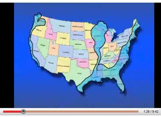
I am including the future maps I mentioned in this post. This one is by Edgar Cayce:
Source: www.disclose.tv...
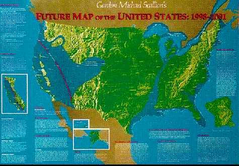
And this one is by Gordon Michael Scallion:
Source: www.fortunecity.com...
Now all this is just me trying to make sense of the forces I am seeing and the reports I am hearing, and I am seeing/hearing eerie correlations to the prophesies I referenced above. I am sure there are plenty of posters on ATS who are much more knowledgeable about tectonics than I, and I am sure they will read this. Please, by all means, if you see a logical error in my thinking, point it out! All I ask is that you point it out logically and with some backup... if someone just says "I don't think you're right", that does no one any good. Tell me why I'm not right! What am I missing?
I really, really don't want to be right...
TheRedneck
Many of you know me. I am not a geology guru, but I am pretty good in the engineering disciplines. When I look at a map of the globe, I see forces and counter-forces. I recently was looking over this thread concerning a small but unusual earthquake in northern central Indiana and remembered a prediction I had quietly made to myself a few months ago. I actually was concerned about an earthquake happening in this area.
Now obviously, I didn't record that prediction, so I am going over this from square one. It starts with the recent BP Gulf Oil disaster.
This is a map I pulled up from Google Maps, on which I superimposed the plate boundaries/faults in red, the forces acting on/from these faults in yellow, and the location of the BP well in green (I don't have Photoshop on this machine, it's still too cold to go to the shop, so forgive my poor skills with inferior software):

The Pacific plate we are all pretty familiar with. It is exerting a small pressure on the American West Coast up to Alaska. There is a small sideways fault in it that ends in northern California, evidence that the tectonic movement is changing either speed or direction along that line. Based on the shape of the Pacific Plate where it interacts with Alaska, I would expect a directional shift northward north of that line and due east south of it.
The small Central American Plate is also pretty familiar to anyone who has looked at fault lines. It appears to me to be pretty dense and immobile, causing islands to pile up around its edge. That would explain why it broke loose into its own plate.
Of course, to the right you will see the Mid-Atlantic Rift, where the plates are pulling apart from each other. What initially got my interest was the shift just east of the St. Lawrence Bay... it looks as though here again, the plate is cracked but this time by a speed shift... as though the plate to the south is moving faster than the one to the north. If you follow this geographic feature, it aligns perfectly with the St. Lawrence River, which is itself something a bit unusual simply due to its size... the river is huge, almost like a gash that happens to be filled with water. Follow this river down and it ends in the Great Lakes, Lake Erie to be precise, and seems to disappear.
Now look at the New Madrid Fault. It extends down the Mississippi River into the Gulf of Mexico, although it is inactive for the most part south of New Madrid. It stops right about the same spot where BP drilled that infamous well.
Putting all this together, I see two plates tightly locked making up the North American continent, not one. The boundary is a line that extends from the Gulf to New Madrid, disappears, then reappears in the Great Lakes and goes up the St. Lawrence. It's like what happens with glass under the right amount of pressure; cracks will form, but sometimes will not connect immediately. The glass stays whole, despite it being cracked, because one section has not completely broken off yet. That is the pattern I am seeing here. The Midwest, Illinois, Indiana, Ohio, are the only thing holding this North American Plate together.
Now, what happened when the well erupted? For a month or more, it was gushing liquid and gas out at an amazing 70,000 psi! I believe that pressure relief caused a chain reaction to begin:
- When the pressure was released, it was no longer opposing the forces that travel down the New Madrid
Fault.
- This could have been sufficient to cause the eastern and western portions of the North American Plate to try and re-distribute the forces along
them, resulting in an increase in shearing force.
- Just like a crack in glass will grow if the shearing force increases, so too could this cause the New Madrid Fault to start slowly extending into
the Midwest
- Evidence of this extension would be expected to be earthquakes in the Midwest of moderate magnitude at first, increasing in frequency and intensity
as the crack grows.
- If the crack bridges the gap between New Madrid and Lake Erie, it will allow the two plate sections to actually slip, causing a more severe
earthquake.
- This could easily cause the fault to open along the Mississippi, turning it into an inlet rather than a river, as has been prophesied by several
people, including Edgar Casey (see below).
- Also in line with those prophesies, this same situation could drop the ground level around the Great Lakes (large enough to mark a weakness in the
crust) and turn that area into one super-Great Lake.
- This will also mark a decrease in pressure on the eastern side of the western section of the North American Plate.
- This will cause the western North American Plate to shift as the pressure from the Pacific Plate is no longer balanced by pressure from the
Mid-Atlantic Rift.
- This shift would cause a massive Californian earthquake as the plates re-balance their forces.
Now please bear in mind I am not making any date predictions here. I honestly have no idea if this could happen in hours, days, weeks, months, years, decades, or at all really. I am throwing it out as a possibility that appears probable to me.
I am including the future maps I mentioned in this post. This one is by Edgar Cayce:
Source: www.disclose.tv...
And this one is by Gordon Michael Scallion:
Source: www.fortunecity.com...
Now all this is just me trying to make sense of the forces I am seeing and the reports I am hearing, and I am seeing/hearing eerie correlations to the prophesies I referenced above. I am sure there are plenty of posters on ATS who are much more knowledgeable about tectonics than I, and I am sure they will read this. Please, by all means, if you see a logical error in my thinking, point it out! All I ask is that you point it out logically and with some backup... if someone just says "I don't think you're right", that does no one any good. Tell me why I'm not right! What am I missing?
I really, really don't want to be right...
TheRedneck
reply to post by TheRedneck
Star and Flag! I think you have set forth a very interesting and well explained post. I remember a toy I had as a child that was a puzzle made out of a hollow plastic sphere. One had to be very very careful in how the assembly process was undertaken if the desired output was a sphere. Perhaps our earth can be likened to that childhood toy?
Star and Flag! I think you have set forth a very interesting and well explained post. I remember a toy I had as a child that was a puzzle made out of a hollow plastic sphere. One had to be very very careful in how the assembly process was undertaken if the desired output was a sphere. Perhaps our earth can be likened to that childhood toy?
reply to post by Dilligaf28
Structural forces are structural forces, whether they move through plastic, steel, or rock...
TheRedneck
Structural forces are structural forces, whether they move through plastic, steel, or rock...
TheRedneck
Isn't there geological evidence of this "layout" from the past like fossils from an inland sea? I thought I read that somewhere.
Great informative post Redneck!
It appears that the loss of such pressure below the New Madrid fault, because of the 'superwell' that was drilled, could cause a massive chain reaction in the existing plates that lie beneath the US.
Ok bear with me. Because this is a crude representation...by an amateur.
I'm not sure what to make of this but here's my un-educated guess:
Take a brownie pan and set it aside.
Now section off the pan with brownies. (baking the brownies is key here)
Carve the middle of the pan in a 2" straight line down the center, and enjoy...
Take milk or another substance and fill the center section you created to the borders.
Place a thin graham cracker pie crust on top and form it so it covers the entire pan over the brownies.
Drain the milk.
Obviously there's no extreme rapid pressure here, but it should do the trick.
Does the pie crust collapse into the crevice you once had filled with milk?
I bet it does.
Sorry, I was hungry and thats the best way I could explain what could happen.
In laymans terms.
Its just an idea.
No prediction.
Here is some info
Michigan Basin info at MSU
Michigan basin at WIKI
Check out the second pic at the wiki site, it shows what they think the area was like along time ago...quite similar to the cayce maps.
Also, don't forget, a huge rift has been opening up in upper penisula of michigan. There is a thread here at ATS somewhere.
reply to post by havok
Something like that. Just imagine you're using a rubber pan and squeezing it from the sides while you drain the milk. Does it collapse?
reply to post by LordBaskettIV
I didn't know about the rift in Michigan's UP... I'll have to look that up. Thanks!
TheRedneck
Something like that. Just imagine you're using a rubber pan and squeezing it from the sides while you drain the milk. Does it collapse?
reply to post by LordBaskettIV
I didn't know about the rift in Michigan's UP... I'll have to look that up. Thanks!
TheRedneck
...interesting subject...
...many decades ago i read that the area around the st lawrence seaway and all the way down the niagra escarpment used to be under the ocean... so, why couldnt it happen again?...
...that fortune city map?... i went there thinking i could find a bigger one but their link opened up the same little bitty map and i cant read whats on there... do you have a bigger one?... if so, could ya share?...
...mostly i'm curious if those light blue areas indicate land thats gonna be underwater... keep flashin on george strait's song "got some ocean front property in arizona"... i wonder how long that phrase has been around... a lot longer than george, i bet...
...and one more thing... if the long expected mega-eruption at yellowstone happened, how do you think that would react with the possibilities in your op?...
I don't know if this helps your thoughts or not, but I saw a program about how the Great Lakes were formed, and if I remember correctly, they whole
area is like a basin, as mentioned above, but that volcanic activity was the cause.
movies.netflix.com...
And, since I live in SE, I hope you are wrong, too.
movies.netflix.com...
And, since I live in SE, I hope you are wrong, too.
Oh, it's going to get scary from here on out.
volcanic past of michigan
Bolding mine, but has to due with rednecks theory.
As far as the rift opening up here is an article on it at a "dubious site" but it has pics of it so...
Mysterious-Rift-Opens-Up-in-Michigan
Beneath the ponds, the forests, and the light soil covering, however, is a story which must be told not in increments of centuries, but by millions and billions of years. The "ridge-and-trough" pattern of the rocks is the work of millions of years, pre-dating even the formation of Lake Superior and its islands. The story begins some 1.2 billion years ago with a great rift in the earth's crust which may have extended from here southward all the way to the Gulf of Mexico. As this series of cracks poured forth molten lava covering thousands of square kilometers, the land along the rift zone sank to form the Superior Basin, which has shaped all subsequent geological events in the region. The rock record of this cataclysmic happening -- the volcanics, sandstones, and conglomerates -- forms Isle Royale's bedrock today. Clues to the island's past abound. Smoothed, rounded, and even groove rock belies the crushing power of the last major glaciation, known as the Wisconsin. It ended here only a few thousand years ago.
volcanic past of michigan
Bolding mine, but has to due with rednecks theory.
As far as the rift opening up here is an article on it at a "dubious site" but it has pics of it so...
Mysterious-Rift-Opens-Up-in-Michigan
edit on 12/30/2010 by LordBaskettIV because: (no reason given)
edit on 12/30/2010 by LordBaskettIV because: link
formatting
reply to post by Wyn Hawks
Mr. Scallion has decided that his future map in full scale is valuable, I'm afraid. I haven't found a full-size copy anywhere that isn't for sale (at what I consider a very high price). The light blue areas are indeed shallow seas.
Personally I place more emphasis on Cayce's map, since it wasn't published for profit. You can also find more maps by others by doing a Google Images search for "future world maps".
I would expect, should the New Madrid Fault crack completely through, that the angle it has with respect to the direction of force would cause the western section of the North American Plate to begin moving in a more northerly direction instead of westerly as it does today. Now that will add to the shear stresses along the San Andreas Fault, since the Pacific Plate is already moving southerly to some degree due to the angle of incidence there. Should Yellowstone erupt and release pressure, it would cause the central section of the western North American Plate to collapse to some degree and actually probably mitigate this increased stress.
That is interesting though... with Yellowstone already showing signs of erupting, a pressure increase might be the tipping point... great questions!
TheRedneck
Mr. Scallion has decided that his future map in full scale is valuable, I'm afraid. I haven't found a full-size copy anywhere that isn't for sale (at what I consider a very high price). The light blue areas are indeed shallow seas.
Personally I place more emphasis on Cayce's map, since it wasn't published for profit. You can also find more maps by others by doing a Google Images search for "future world maps".
if the long expected mega-eruption at yellowstone happened, how do you think that would react with the possibilities in your op?...
I would expect, should the New Madrid Fault crack completely through, that the angle it has with respect to the direction of force would cause the western section of the North American Plate to begin moving in a more northerly direction instead of westerly as it does today. Now that will add to the shear stresses along the San Andreas Fault, since the Pacific Plate is already moving southerly to some degree due to the angle of incidence there. Should Yellowstone erupt and release pressure, it would cause the central section of the western North American Plate to collapse to some degree and actually probably mitigate this increased stress.
That is interesting though... with Yellowstone already showing signs of erupting, a pressure increase might be the tipping point... great questions!
TheRedneck
...ever hear of the wabash seismic zone or the cottage grove fault?... i hadnt... the new madrid system is much bigger and more active than i
thought...
www.ehow.com...
www.ehow.com...
Two Seismic Zones Connect
•Centered in the Wabash River Valley, the Wabash Valley Seismic Zone straddles the state line between southeastern Illinois and southwestern Indiana and spreads into part of western Kentucky. Scientists believe that it is a branch of the New Madrid system, which extends south from Cairo, Illinois, through Missouri, Arkansas, Mississippi and parts of western Tennessee, according to the Arkansas Center for Earthquake Education and Technology Transfer.
Scientists Discover Another Fault
•The 1968 Illinois earthquake or New Madrid event, hit Illinois on November 9, 1968, and measured 5.4 on the Richter scale. It affected 23 states over an area of 580,000 square miles, causing much structural damage to buildings but no fatalities. In researching its cause, scientists discovered the Cottage Grove Fault in the Southern Illinois Basin, which is a small tear in the Earth's rock running west to east under Saline County, near Harrisburg, Illinois. It connects to the north-south running Wabash Valley Fault System at its eastern end.
This will be one of the most selfish superficial things I have ever said, but good lord, if this happens I hope I am dead and buried when it does.
It isn't, bye the way, something you would consider eminent?
And Wyn, the entire Yellowstone disaster is just too much to fathom.
It isn't, bye the way, something you would consider eminent?
And Wyn, the entire Yellowstone disaster is just too much to fathom.
Good evening, my good friend.
You have an interesting theory.
One factor concerning the area in question is the fact that the earthquakes that occur in or near the New Madrid fault, are, in many cases,due not to primary plate tectonic forces, but a secondary force of liquefaction, as a result of primary quakes. The Indiana quake was most likely caused by liquefaction. Your theory of oil spill certainly can factor into quakes, as the oil creates, in effect, the same response that standard water liquefaction creates.
Everyone is familiar with the primary quakes of the California area, caused by plate movements in opposite directions, and draw similar scenarios for the New Madrid area. In many cases, these similarities fail to explain the New Madrid quakes so easily.
The area that the quake occurred in has many oil refineries, and it is quite possible that future earthquakes could damage those refineries and lead to further problems. In addition, unreported oil spills on land, could be responsible for some of those quakes.(After all, this is a conspiracy site!)
Peace, my friend.
Thanks for the interesting read. It made me think of the Lost River in Indiana. Here's a description of it:
Source:en.wikipedia.org...
The following link is to information on caves in Southern Indiana
www.associatedcontent.com...
I'm not sure how all this would affect what you are describing, if at all. At the very least, it could possibly cause cave-ins, resulting in sink holes. Then again, I'm not a geologist and I'm most likely wrong.
The Lost River is about 85 miles (137 km) long and its name is derived from the fact that at least 23 miles (37 km) of the primary course of the river flows completely underground. The river's underground channels may in fact cover hundreds of miles, as the underground caverns have never been fully explored. The river disappears into a series of sink holes of the type that are abundant in the karstland of southern Indiana. In one square mile there are as many as 1,022 sink holes. The river slips into and out of these sink holes at various points flowing into hidden underground caverns that connect with multiple other streams, rivers, and springs.[2] The River begins as a normal river in Washington County, but soon after rising, the river flows over and into a limestone bed (karst) for several miles until the stream bed turns dry; the water is absorbed into the limestone and sinks beneath the surface to a hidden cavern. The river then flows underground through a network of caves and channels through part of Orleans Township, Paoli Township, and part of Orangeville Township before reappearing on the surface near the village of Orangeville, Indiana. Where the river rises from surface in Orange County it produces a spring that is 165 feet (50 m) deep with the very bottom connecting to the actual underground channel. This spring is the second largest in the state known as the True Rise because many inaccurately believe the that Orangeville Rise is the main channel of the river.[3] The Orangeville rise is a likely tributary of the underground Lost River.[2] The river then continues its westward flow above ground. The rise in Orangeville unfortunately is not picturesque, but is little more than a gloomy pond that feeds a muddy stream.
Source:en.wikipedia.org...
The following link is to information on caves in Southern Indiana
www.associatedcontent.com...
I'm not sure how all this would affect what you are describing, if at all. At the very least, it could possibly cause cave-ins, resulting in sink holes. Then again, I'm not a geologist and I'm most likely wrong.
edit on 30-12-2010 by Skid Mark because: punctation
Originally posted by ladyinwaiting
This will be one of the most selfish superficial things I have ever said, but good lord, if this happens I hope I am dead and buried when it does.
...i know selfish and superficial - that aint it...
...it would be difficult to witness such a thing due to all the loss of life - but - after thinking about it for a while, i think it could also be an amazing thing to witness because it would be a new beginning... of course theres no guarantee that what would follow would be an improvement but we might get lucky...
Originally posted by ladyinwaiting
And Wyn, the entire Yellowstone disaster is just too much to fathom.
...yeah, especially if you live out that way - which i dont and i wont ever - not that texas is any safer with all the pipelines, salt domes, refineries and we have shakers here too... nothing extraordinary in a long time but ya never know when that cycle is gonna come back around...
Maybe it's time to head for the hills. I'm about a mile from the St. Lawrence. I always used to say, "nothing ever happens here." Maybe I'll have
to eat my words.
Very interesting thread, S&F.
Edited to remove duplicate link and info. Already posted above - doh!
Edited to remove duplicate link and info. Already posted above - doh!
edit on 31-12-2010 by StarTraveller because: (no reason given)
reply to post by ProfEmeritus
Well, hello Prof!
I am going to hereby appoint you as the expert in liquefaction on this thread, as my knowledge of that particular subject is somewhat superficial. I was thinking about what you wrote while checking out Win Hawk's link above. I am starting to wonder if this broken fault line between the eastern and western portions of the North American Plate is not the remnants of a more active prehistoric fault line... after all, something caused the Appalachians to form, and mountain ranges typically seem to form closer to the edges of a plate rather than in the center.
Could liquefaction over eons cause a fault to heal itself, sort of like welding the plates back together? And could the Midwest be sitting atop such a healed area in a much larger New Madrid Fault Zone than was originally thought? And could that mean that there is an inherent weakness in this area that is just now reforming into an active fault zone, accelerated by the release of restraining pressure from the BP oil well disaster?
As usual, a brilliant insight!
TheRedneck
new topics
-
What is the white pill?
Philosophy and Metaphysics: 57 minutes ago -
Mike Pinder The Moody Blues R.I.P.
Music: 1 hours ago -
Putin, Russia and the Great Architects of the Universe
ATS Skunk Works: 4 hours ago -
A Warning to America: 25 Ways the US is Being Destroyed
New World Order: 9 hours ago
top topics
-
President BIDEN's FBI Raided Donald Trump's Florida Home for OBAMA-NORTH KOREA Documents.
Political Conspiracies: 14 hours ago, 33 flags -
A Warning to America: 25 Ways the US is Being Destroyed
New World Order: 9 hours ago, 18 flags -
Is AI Better Than the Hollywood Elite?
Movies: 16 hours ago, 4 flags -
Mike Pinder The Moody Blues R.I.P.
Music: 1 hours ago, 4 flags -
What is the white pill?
Philosophy and Metaphysics: 57 minutes ago, 4 flags -
Putin, Russia and the Great Architects of the Universe
ATS Skunk Works: 4 hours ago, 2 flags -
Maestro Benedetto
Literature: 16 hours ago, 1 flags
active topics
-
One Flame Throwing Robot Dog for Christmas Please!
Weaponry • 11 • : Therealbeverage -
Gaza Terrorists Attack US Humanitarian Pier During Construction
Middle East Issues • 65 • : CarlLaFong -
Ditching physical money
History • 21 • : SprocketUK -
What is the white pill?
Philosophy and Metaphysics • 3 • : watchitburn -
Graham Hancock being proven right all along about ancient humans in America.
Ancient & Lost Civilizations • 106 • : JonnyC555 -
President BIDEN's FBI Raided Donald Trump's Florida Home for OBAMA-NORTH KOREA Documents.
Political Conspiracies • 29 • : MetalThunder -
Putin, Russia and the Great Architects of the Universe
ATS Skunk Works • 17 • : BrotherKinsMan -
Massachusetts Drag Queen Leads Young Kids in Free Palestine Chant
Social Issues and Civil Unrest • 18 • : ToneD -
Mood Music Part VI
Music • 3109 • : TheWoker -
Candidate TRUMP Now Has Crazy Judge JUAN MERCHAN After Him - The Stormy Daniels Hush-Money Case.
Political Conspiracies • 791 • : matafuchs