It looks like you're using an Ad Blocker.
Please white-list or disable AboveTopSecret.com in your ad-blocking tool.
Thank you.
Some features of ATS will be disabled while you continue to use an ad-blocker.

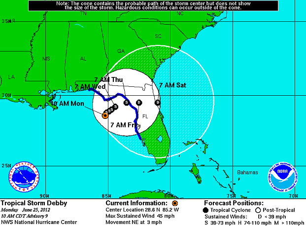
Tropical Storm Debby heading to a city on the Gulf Coast soon.
page: 2share:
reply to post by Ladysophiaofsandoz
Holy cow, great pictures! Most of those would really make me head for the hills. Did you take all of those. If so, you are one brave person.
Holy cow, great pictures! Most of those would really make me head for the hills. Did you take all of those. If so, you are one brave person.
CHANGES WITH THIS ADVISORY...
THE TROPICAL STORM WARNING FROM THE FLORIDA-ALABAMA BORDER TO DESTIN HAS BEEN DISCONTINUED.
THE TROPICAL STORM WATCH FROM THE SUWANNEE RIVER TO ENGLEWOOD HAS BEEN CHANGED TO A TROPICAL STORM WARNING.
SUMMARY OF WATCHES AND WARNINGS IN EFFECT... A TROPICAL STORM WARNING IS IN EFFECT FOR... * THE FLORIDA GULF COAST FROM DESTIN TO ENGLEWOOD FOR STORM INFORMATION SPECIFIC TO YOUR AREA INCLUDING POSSIBLE INLAND WATCHES AND WARNINGS...PLEASE MONITOR PRODUCTS ISSUED BY YOUR LOCAL NATIONAL WEATHER SERVICE FORECAST OFFICE.
Source Noaa.gov
Well, maybe the Pensacola area that had all the rain a couple of weeks ago might be spared from this flood.
No I didn't take these myself they were all posted elsewhere by friends and family in the area. My camera is Japanese and thus hates me, I seem to
have some problem dealing with electronics from Japan. Weird stuff happens and it wont behave for me. Everyone thinks I am making it up untill they
see it themselves and then it's all "DONT TOUCH IT!"
Heading towards the florida west coast on a delayed schedule.
I saw a tweet by Jim Cantore with the Weather Channel that had an interesting observation.
twitter.com
The tweet links out to a NOAA animation of the change in Debby's projected path. You can view that at nhc.noaa.gov. Pretty interesting.
Hope everyone is safe!
OiO
In a little more than 24 hours Debby's track has changed 180 degrees
twitter.com
The tweet links out to a NOAA animation of the change in Debby's projected path. You can view that at nhc.noaa.gov. Pretty interesting.
Hope everyone is safe!
OiO
I'm in the Tampa Bay area as well, southern shores. I'm surprised we haven't gotten nearly as much rain as everyone else around us, but at least we
don't have to deal with flooded roads & homes. Even the damage is nominal, mainly tossed business sign marquees. I'm also very miffed that at the
moment, we're under a Tropical Storm Warning, with it sitting pretty much right on top of us, but yet, I look outside and it's sunny o.O That's not
how that's supposed to go. This one does nothing predictable, that's for sure.
CHANGES WITH THIS ADVISORY... THE TROPICAL STORM WARNING HAS BEEN DISCONTINUED WEST OF MEXICO BEACH FLORIDA.
SUMMARY OF WATCHES AND WARNINGS IN EFFECT... A TROPICAL STORM WARNING IS IN EFFECT FOR... * THE FLORIDA GULF COAST FROM MEXICO BEACH TO ENGLEWOOD
FOR STORM INFORMATION SPECIFIC TO YOUR AREA IN THE UNITED STATES...INCLUDING POSSIBLE INLAND WATCHES AND WARNINGS...PLEASE MONITOR PRODUCTS ISSUED BY YOUR LOCAL NATIONAL WEATHER SERVICE FORECAST OFFICE.
Noaa.gov
reply to post by Ladysophiaofsandoz
I feel sorry for that boat owner, that looks like it was a nice boat.
I also feel your pain on the camera issues. I bought one that was really expensive because of all the bells and whistles and can't use the dang thing. I am sure it would take beautiful pictures if I could figure it out.
I feel sorry for that boat owner, that looks like it was a nice boat.
I also feel your pain on the camera issues. I bought one that was really expensive because of all the bells and whistles and can't use the dang thing. I am sure it would take beautiful pictures if I could figure it out.
Wow, kind of off subject, but does anyone live in Corpus Christi? It was a record high today at 105!
Seems like Debby is sucking the city dry of it's moisture! No pun intended.
Maybe.
Corpus Christi record heat!
Seems like Debby is sucking the city dry of it's moisture! No pun intended.
Maybe.
Corpus Christi record heat!
reply to post by LeTan
I don't live in Corpus Christi, but it is steaming hot everywhere I think. Here in TN, I had to go buy a window a/c unit just to keep up with the heat. My poor little hvac was just over worked.
I don't live in Corpus Christi, but it is steaming hot everywhere I think. Here in TN, I had to go buy a window a/c unit just to keep up with the heat. My poor little hvac was just over worked.
I'm in the Tampa Bay area. I head across the Howard Frankland Bridge each day, to and from work. Yesterday, and this morning, the water is often
spilling over the seawall, and coming between the gaps in the concrete barriers. I'm actually surprised it's still open. They did shut it down last
night. Luckily, I guessed that would happen, and worked from home yesterday. If not, I'd have been stranded in St. Pete.
Trying to be at the office today, so hopefully I don't get trapped tonight. Another co-worker is on a small island (Snell Isle), and she's completely flooded in. That area is bad for it, but this is worse than I've seen it there...and all from a relatively minor storm. It's just that it's dumping SO much rain, and nowhere for it to go.
Weird too, an hour ago, it was sheets of rain. Now, all sunshine. Two hours from now, probably another downpour. The wind is the real trick with driving (and road debris like small branches, palm fronds, etc.). Had to clean out my driveway last night, so I could get out this morning. At least I've got a big truck to handle any rising water.
000
WTNT34 KNHC 261451
TCPAT4
BULLETIN
TROPICAL STORM DEBBY ADVISORY NUMBER 13
NWS NATIONAL HURRICANE CENTER MIAMI FL AL042012
1100 AM EDT TUE JUN 26 2012
...DEBBY SLOWLY WEAKENING BUT FLOODING THREAT CONTINUES
ACROSS FLORIDA AND SOUTHERN GEORGIA...
SUMMARY OF 1100 AM EDT...1500 UTC...INFORMATION
-----------------------------------------------
LOCATION...28.9N 84.2W
ABOUT 70 MI...110 KM W OF CEDAR KEY FLORIDA
MAXIMUM SUSTAINED WINDS...40 MPH...65 KM/H
PRESENT MOVEMENT...E OR 90 DEGREES AT 3 MPH...6 KM/H
MINIMUM CENTRAL PRESSURE...993 MB...29.32 INCHES
WATCHES AND WARNINGS
--------------------
CHANGES WITH THIS ADVISORY...
NONE.
SUMMARY OF WATCHES AND WARNINGS IN EFFECT...
A TROPICAL STORM WARNING IS IN EFFECT FOR...
* THE FLORIDA GULF COAST FROM MEXICO BEACH TO ENGLEWOOD
FOR STORM INFORMATION SPECIFIC TO YOUR AREA...INCLUDING POSSIBLE
INLAND WATCHES AND WARNINGS...PLEASE MONITOR PRODUCTS ISSUED BY
YOUR LOCAL NATIONAL WEATHER SERVICE FORECAST OFFICE.
DISCUSSION AND 48-HOUR OUTLOOK
------------------------------
AT 1100 AM EDT...1500 UTC...THE CENTER OF TROPICAL STORM DEBBY WAS
LOCATED NEAR LATITUDE 28.9 NORTH...LONGITUDE 84.2 WEST. DEBBY IS
MOVING TOWARD THE EAST NEAR 3 MPH...6 KM/H. AN EASTWARD OR EAST-
NORTHEASTWARD MOTION WITH SOME INCREASE IN FORWARD SPEED IS
EXPECTED DURING THE NEXT COUPLE OF DAYS...AND THE CENTER OF DEBBY
SHOULD BE MOVING ACROSS NORTH-CENTRAL FLORIDA TOMORROW.
MAXIMUM SUSTAINED WINDS HAVE DECREASED TO NEAR 40 MPH...65
KM/H...WITH HIGHER GUSTS. DEBBY IS EXPECTED TO WEAKEN TO A TROPICAL
DEPRESSION OVER THE NEXT DAY OR TWO.
TROPICAL-STORM-FORCE WINDS EXTEND OUTWARD UP TO 205 MILES...335
KM...MAINLY TO THE SOUTHEAST OF THE CENTER.
THE ESTIMATED MINIMUM CENTRAL PRESSURE IS 993 MB...29.32 INCHES.
HAZARDS AFFECTING LAND
----------------------
WIND...TROPICAL STORM CONDITIONS WILL CONTINUE OVER PORTIONS OF
THE FLORIDA GULF COAST TODAY.
STORM SURGE...EVEN THOUGH DEBBY CONTINUES TO SLOWLY WEAKEN...COASTAL
FLOODING WILL CONTINUE DURING THE NEXT DAY OR TWO DUE TO PERSISTENT
ONSHORE WINDS. THE COMBINATION OF A STORM SURGE AND THE TIDE WILL
CAUSE NORMALLY DRY AREAS NEAR THE COAST TO BE FLOODED BY RISING
WATERS DURING THE NEXT HIGH TIDE LATER TODAY. THE WATER COULD REACH
THE FOLLOWING DEPTHS ABOVE GROUND...
APALACHEE BAY AND THE NATURE COAST...2 TO 4 FT
SOUTH OF THE NATURE COAST INCLUDING TAMPA BAY...1 TO 3 FT
THE DEEPEST WATER WILL OCCUR ALONG THE IMMEDIATE COAST IN AREAS OF
ONSHORE FLOW. SURGE-RELATED FLOODING DEPENDS ON THE RELATIVE
TIMING OF THE SURGE AND THE TIDAL CYCLE...AND CAN VARY GREATLY OVER
SHORT DISTANCES. FOR INFORMATION SPECIFIC TO YOUR AREA...PLEASE
SEE PRODUCTS ISSUED BY YOUR LOCAL NATIONAL WEATHER SERVICE OFFICE.
RAINFALL...DEBBY IS EXPECTED TO PRODUCE ADDITIONAL RAIN
ACCUMULATIONS OF 4 TO 8 INCHES OVER NORTHERN FLORIDA AND EXTREME
SOUTHEASTERN GEORGIA DURING THE NEXT COUPLE OF DAYS. ISOLATED STORM
TOTAL AMOUNTS OF 25 INCHES ARE POSSIBLE IN NORTHERN FLORIDA.
TORNADOES...ISOLATED TORNADOES ARE POSSIBLE ACROSS THE FLORIDA
PENINSULA TODAY.
NEXT ADVISORY
-------------
NEXT INTERMEDIATE ADVISORY...200 PM EDT.
NEXT COMPLETE ADVISORY...500 PM EDT.
$$
FORECASTER KIMBERLAIN/FRANKLIN
edit on 26-6-2012 by Gazrok because: (no reason given)
2 and 1/2 days without power. Wish I could thank the power guys who came in from out of state to restore my electric.
Although this storm has moved on there has not been flooding in Live Oak, Florida like this since 1940`s.
The court house in Live Oak also appears to be in big trouble due to there is a sink hole under it. They figured there was a sink hole due to the water had disappeared and drained.
There are many sink holes in the area now.
Here is a video of the town up the road. Lucky for us we live on a high area it seems but we can`t get to like Wal-mart or Live Oak ourselves yet. Watch this to see what is floating at the very end as well.
Now there was a lady that was needing help and said that her goats had drowned and they where trapped needing help with anyone with a boat.
I would say this is nowhere near the end of clean-up and helping people. I have been following the Colorado wildfire thread and between both of these
disasters the American population is taking a pretty big hit. Prayers to those that are suffering from Mother Natures wrath.
new topics
-
Zombie apocalypse - dead registering to vote in massive numbers!
US Political Madness: 13 minutes ago -
Tick...tock...What one thing on ATS?
General Conspiracies: 1 hours ago -
5 soldiers killed, 7 hurt in ‘friendly fire’ incident in northern Gaza’s Jabaliya
Middle East Issues: 1 hours ago -
WATCH Two Russian Soldiers Cheat Death Multiple Time While Riding a Motorbike In battleground
World War Three: 3 hours ago -
CNN John Fritze and The New York Times Can Kiss My Rosey Red
Mainstream News: 5 hours ago -
The Vatican Press Conference to Discuss Apparitions and The Supernatural
Paranormal Studies: 6 hours ago -
Biden claims he brought inflation down from 9 to 3 percent
US Political Madness: 9 hours ago -
The Biden-Hur Tapes
US Political Madness: 10 hours ago -
Weird and unexpected premonitions.
Dreams & Predictions: 11 hours ago
top topics
-
RFK Jr Being Left Out of the 2024 POTUS Debate
2024 Elections: 15 hours ago, 11 flags -
Biden claims he brought inflation down from 9 to 3 percent
US Political Madness: 9 hours ago, 8 flags -
The big spin, how main stream media controlled the narrative.
Propaganda Mill: 17 hours ago, 6 flags -
The Biden-Hur Tapes
US Political Madness: 10 hours ago, 5 flags -
CNN John Fritze and The New York Times Can Kiss My Rosey Red
Mainstream News: 5 hours ago, 5 flags -
Pro-Israel billionaires urged New York crackdown on Gaza protests
Social Issues and Civil Unrest: 12 hours ago, 3 flags -
Tick...tock...What one thing on ATS?
General Conspiracies: 1 hours ago, 1 flags -
WATCH Two Russian Soldiers Cheat Death Multiple Time While Riding a Motorbike In battleground
World War Three: 3 hours ago, 1 flags -
Zombie apocalypse - dead registering to vote in massive numbers!
US Political Madness: 13 minutes ago, 1 flags -
Weird and unexpected premonitions.
Dreams & Predictions: 11 hours ago, 1 flags
active topics
-
Remember the Kibbutz UFO? Lookie here
Aliens and UFOs • 11 • : xWorldxGonexMadx -
CNN John Fritze and The New York Times Can Kiss My Rosey Red
Mainstream News • 3 • : chiefsmom -
Biden accepts Trumps debate challenge
2024 Elections • 126 • : Oldcarpy2 -
Gaza Genocide Real or Propaganda
Middle East Issues • 500 • : some_stupid_name -
5 soldiers killed, 7 hurt in ‘friendly fire’ incident in northern Gaza’s Jabaliya
Middle East Issues • 10 • : Lazy88 -
Tick...tock...What one thing on ATS?
General Conspiracies • 5 • : kwaka -
Spy Music
Music • 47 • : Hellmutt -
Biden claims he brought inflation down from 9 to 3 percent
US Political Madness • 18 • : Shoshanna -
Zombie apocalypse - dead registering to vote in massive numbers!
US Political Madness • 0 • : pianopraze -
RFK Jr Being Left Out of the 2024 POTUS Debate
2024 Elections • 14 • : chiefsmom