It looks like you're using an Ad Blocker.
Please white-list or disable AboveTopSecret.com in your ad-blocking tool.
Thank you.
Some features of ATS will be disabled while you continue to use an ad-blocker.

A Gigantic Pyramid on Ocean Sea Floor in Bermuda Triangle?
page: 2share:
nice find,
i remember reading about pyramids in bermuda,
check the link below
bermuda pyramids
not a very credible source though
i remember reading about pyramids in bermuda,
check the link below
bermuda pyramids
not a very credible source though
is it aligned along the compass points or if we went back 7-10 thousand years to any major stars/constellations and it doesnt look like theres much
around it but 10,000 years of sediment would hide most normal man made objects so if we could work out the original floor height before the waters
covered it up then perhaps its height could be worked out and seen if it relates to others?
reply to post by mab22
The article you linked may not be far from the truth.
There is large underwater ruins between the Yucatan peninsula and Cuba.
The side scans pictured below are from India and are of an ancient city
about 5000 years old. As you can see the scan does'nt look like much either,
bloody crap radar images
What! Let's read that last sentence again
Here's the link to www.archaeologyonline.net
Gee wiz
An advanced race in pre-history, who would have guessed
The article you linked may not be far from the truth.
There is large underwater ruins between the Yucatan peninsula and Cuba.
The side scans pictured below are from India and are of an ancient city
about 5000 years old. As you can see the scan does'nt look like much either,
bloody crap radar images
For decades archaeologists have argued about the origins of the mysterious “Harappan” (Indus Valley) civilisation that flourished across what is now Pakistan and northwest India from about 3000 BC. Now, new findings by Indian scientists working in the Gulf of Cambay suggest that the Harappans were descended from an advanced mother culture that flourished at the end of the last Ice Age that was then submerged by rising sea levels before ‘history’ began.
What! Let's read that last sentence again
Now, new findings by Indian scientists working in the Gulf of Cambay suggest that the Harappans were descended from an advanced mother culture that flourished at the end of the last Ice Age that was then submerged by rising sea levels before ‘history’ began.
Here's the link to www.archaeologyonline.net
Gee wiz
An advanced race in pre-history, who would have guessed
edit on 31-1-2012 by LeLeu because: (no reason given)
reply to post by Arken
Another AMAZING find Arken I feel there is much hidden data about the past of humans and possible others hidden under new sea floor from past Earth cycles in relation to crust movements and water relocation. It makes you wonder why the bottom of the oceans floors haven't been mapped fully. But then when you consider a potential space related navy it makes sense they would exist for any incoming space objects have a larger chance of entering the oceans instead of land impact and some water related security should be there to analyze.
SnF
Originally posted by mab22
nice find,
i remember reading about pyramids in bermuda,
check the link below
bermuda pyramids
not a very credible source though
The Article You linked... very, very odd!
reply to post by Ophiuchus 13
In all honesty, it isn't as simple as just mapping the Oceans. After 5000 plus years (minimum) of sea currents running over any ruins, sediment burying anything and changing sea levels creating differing tidal forces on possible locations, the chances of any significant city type sites being located is very small and the cost to search is eye wateringly high. The chances are that any finds would be crushed fragments, not easy to find under tonnes of sediment at the bottom of the sea.
I suspect that future finds off shore will be linked to significant discoveries made on land - things that will give clues as to where to search. Until then, the oceans are too big and expensive to properly scour.
Originally posted by Ophiuchus 13
reply to post by Arken
Another AMAZING find Arken I feel there is much hidden data about the past of humans and possible others hidden under new sea floor from past Earth cycles in relation to crust movements and water relocation. It makes you wonder why the bottom of the oceans floors haven't been mapped fully. But then when you consider a potential space related navy it makes sense they would exist for any incoming space objects have a larger chance of entering the oceans instead of land impact and some water related security should be there to analyze. SnF
Absolutely, my friend.
The Oceans hide our unknown past like Space...
Originally posted by Flavian
reply to post by Ophiuchus 13
In all honesty, it isn't as simple as just mapping the Oceans. After 5000 plus years (minimum) of sea currents running over any ruins, sediment burying anything and changing sea levels creating differing tidal forces on possible locations, the chances of any significant city type sites being located is very small and the cost to search is eye wateringly high. The chances are that any finds would be crushed fragments, not easy to find under tonnes of sediment at the bottom of the sea.
I suspect that future finds off shore will be linked to significant discoveries made on land - things that will give clues as to where to search. Until then, the oceans are too big and expensive to properly scour.
Yes I can agree with that but when you consider high tech scan potentials its not hard to consider the technology existing that would allow satilite and mobile microwave sonar or some other kind of wave scanning tech being available for them to scan earth well from space sea or even from towers on land. So I think it can be done. The financial cost may be staggering but imagine they find a treasure of pricey metallics down there or even ancient tech the find would fund the exploration cost. I just think there are some of Earth who either know whats REALLY down there and are told to keep it "hush" by unforseen influences upon Earth (like no tresspassing) somewhat. But I see your point. A machin like haarp array working the land and space HARMONICS CAN ALSO DETECT WHATS BELOW THE SEDIMENT EVEN IF SEDIMENT COVERING IN THOUSANDS OF FEET LAYERS.
edit on 1/31/12 by
Ophiuchus 13 because: (no reason given)
Originally posted by Arken
Originally posted by Ophiuchus 13
reply to post by Arken
Another AMAZING find Arken I feel there is much hidden data about the past of humans and possible others hidden under new sea floor from past Earth cycles in relation to crust movements and water relocation. It makes you wonder why the bottom of the oceans floors haven't been mapped fully. But then when you consider a potential space related navy it makes sense they would exist for any incoming space objects have a larger chance of entering the oceans instead of land impact and some water related security should be there to analyze. SnF
Absolutely, my friend.
The Oceans hide our unknown past like Space...
I agree and they may hide the past of OTHERs not from or even native of Earth as well. Imagine not a gloom scenerio but a location currently above ground say with large stock piles of minerals gold diamonds ect. and then this region became covered by oceans and previous oceans area became land that "VAULT" or vaults would stay beneath undetected until found or until that region came back above ground again. I love the mysteries of this planet it keps you motivated to seek more TRUTH...
reply to post by Ophiuchus 13
If we get the tech, i would start with shore lines from around 10'000 to 5'000 years ago, worldwide. I would start off the east coast of India, around Sri Lanka, definitely all of the Black Sea region, as well as west coast Europe and east coast America / Caribbean.
If we get the tech, i would start with shore lines from around 10'000 to 5'000 years ago, worldwide. I would start off the east coast of India, around Sri Lanka, definitely all of the Black Sea region, as well as west coast Europe and east coast America / Caribbean.
reply to post by Arken
I like it..Very interesting..Hope there is something to it.
Sohas anything out of the ordinary happened over the pyramids we have on land?
Wasn't it mentioned one in Biosnia was projecting some sort of beam? or was that bogus?
s&f
I like it..Very interesting..Hope there is something to it.
Sohas anything out of the ordinary happened over the pyramids we have on land?
Wasn't it mentioned one in Biosnia was projecting some sort of beam? or was that bogus?
s&f
edit on 31-1-2012 by wutz4tom because: (no reason given)
If that is an accurate image that pyramid show almost zero erosion. The visible edges appear to be sharp and exact...perfect really. Wouldn't
something under water for that long have been smoothed by the currents or dissolved by the salt water even a little bit? Maybe it was buried and
protected by sediment or mud ... but still.
I'm leaning towards it being some sort of false artifact made by the camera/sonar equipment, or maybe pixelization.
I'm leaning towards it being some sort of false artifact made by the camera/sonar equipment, or maybe pixelization.
in spirit science he talks about a merkaba being in the bermuta triangle (atlantis) check it out
youtu.be...
youtu.be...
Hello Arken.
I have heard about the pyramids off of Florida, I find it to be quite interesting. I am not sure what or who they belong to but pyramids are all over the world. They meant something to many all over.
I came across this this morning and ironically enough I came across your thread shortly after.
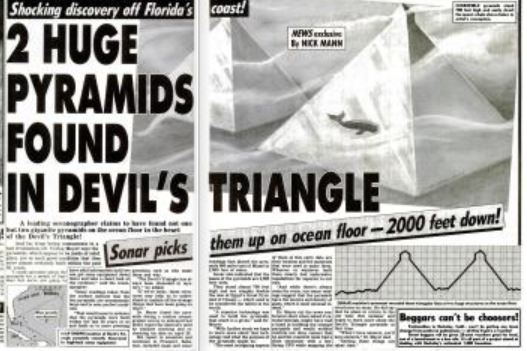
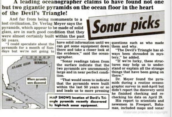
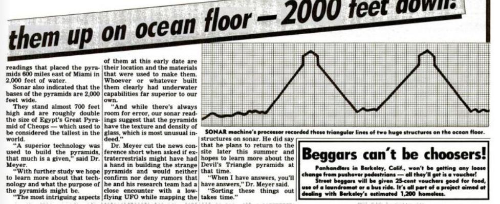
This is a newspaper article from 1987 here in Florida. A guy claims to have found a pyramid off the coast of Florida, more specifically Indian River County. That is just south of me by about 20mins beachside. I quickly looked for more information but I can only find various articles on the same subject and they are from the 80s. Maybe you have come across this?
source
Here is a link to the actual news paper article.
Google Newspaper, FL pyramid
Not sure how accurate this is. I did google the other guys name, Mel Fisher and found out who he was. Alfred though I can't find all that much on.
Cool thread. I am gonna look at this area on google earth and see if anything comes up.
I have heard about the pyramids off of Florida, I find it to be quite interesting. I am not sure what or who they belong to but pyramids are all over the world. They meant something to many all over.
I came across this this morning and ironically enough I came across your thread shortly after.
This is a newspaper article from 1987 here in Florida. A guy claims to have found a pyramid off the coast of Florida, more specifically Indian River County. That is just south of me by about 20mins beachside. I quickly looked for more information but I can only find various articles on the same subject and they are from the 80s. Maybe you have come across this?
March 16, 1987|By JAY HAMBURG, The Orlando Sentinel
ORLANDO -- Alfred Conway keeps remembering the days he used to hunt treasure with Mel Fisher, who is rich as a pirate king since finding the gold-laden Atocha off Key West.
Conway, a Vero Beach treasure hunter, has yet to uncover a bounty rich as his friend`s. But he claims to have found an underwater pyramid off Indian River County.
source
Here is a link to the actual news paper article.
Google Newspaper, FL pyramid
Not sure how accurate this is. I did google the other guys name, Mel Fisher and found out who he was. Alfred though I can't find all that much on.
Cool thread. I am gonna look at this area on google earth and see if anything comes up.
reply to post by mblahnikluver
Thanks for your contribution, my friend.
In this time we would have had need the "Justin" experience...
Thanks for your contribution, my friend.
In this time we would have had need the "Justin" experience...
edit on 31-1-2012 by Arken because: (no reason given)
Tell me something I don't know!! Of course there is a pyramid on the ocean floor! It's not the only one or man made structure in the ocean. It used
to be dry land. Then the flood came and wiped everything out. I thought you all would now this by now! Remember, people used to populate the whole
world. Populations were not just confined to certain areas. In the book of Genesis in the Holy Bible, it talks about people living through out the
whole earth! They built great cities. Then the populace sined greatly and God caused a flood and wiped them all out except Noah and his family. Then
after the flood receded, Noah and his family repoulated the earth. Not just the middle east or surrounding areas. The whole Earth. That's why you
have the same tales in all cultures. That's why there are pyramids on all continents! That's why you see white and african sculptures in south
America. Thats why we find Hebrew and a sub Phonecian language throught North and South America. I could go on but you get the point.
Interesting image but the images produced by side scan sonar can be deceptive. A steeply raised object should produce a "shadow". The "pyramid" shows
no shadow.
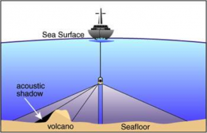
It should also be noted that the sonar data has undergone quite a lot of processing and the image is built up from a mosaic of many passes of the vessel. As can be seen in better resolution, the "pyramid" seems to be the stitching lines between several mosiac parts.
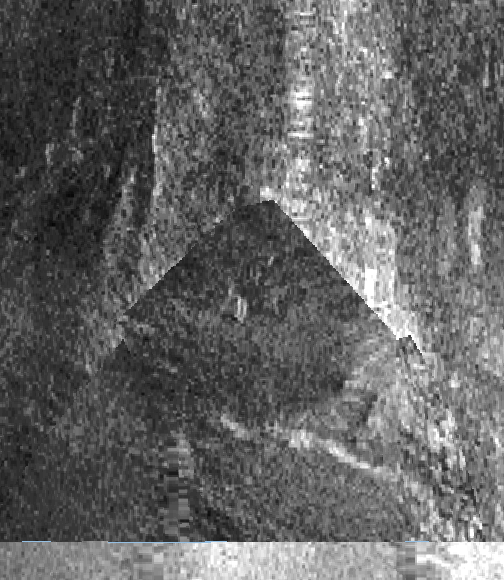
coastalmap.marine.usgs.gov...
The "pyramid" is about 6 miles across at its base and lies in waters more than 5,000 feet deep. That undersea terrain was never uncovered.
It should also be noted that the sonar data has undergone quite a lot of processing and the image is built up from a mosaic of many passes of the vessel. As can be seen in better resolution, the "pyramid" seems to be the stitching lines between several mosiac parts.
coastalmap.marine.usgs.gov...
The "pyramid" is about 6 miles across at its base and lies in waters more than 5,000 feet deep. That undersea terrain was never uncovered.
edit on 1/31/2012 by Phage because: (no reason given)
reply to post by Phage
I just do not understand the science behind this bit, it makes my eyes cross and my brain melt. However, i have to admit that seems a highly plausible explanation. You sod!
I just do not understand the science behind this bit, it makes my eyes cross and my brain melt. However, i have to admit that seems a highly plausible explanation. You sod!
Originally posted by Phage
Interesting image but the images produced by side scan sonar can be deceptive. A steeply raised object should produce a "shadow". The "pyramid" shows no shadow.
It should also be noted that the sonar data has undergone quite a lot of processing and the image is built up from a mosaic of many passes of the vessel. As can be seen in better resolution, the "pyramid" seems to be the stitching lines between several mosiac parts.
coastalmap.marine.usgs.gov...
The "pyramid" is about 6 miles across at its base and lies in waters more than 5,000 feet deep. That undersea terrain was never uncovered.
edit on 1/31/2012 by Phage because: (no reason given)
Use his link above for the CMGP Map viewer and put our pointer on these coordinates and make the map viewer big and the coords are on bottom left of page
30.066535
76.735237
These will put you directly on the pyramid shape. Interesting find although I agree with the Biblcal comment of the flood and the great plains being covered I think if you look at this picture on the map viewer you do not see any of the other scans producing these straight lines or triangle pyramidal effects in fact they seem to mostly swirl. I think this could be something worth looking at also. But again it is just pre-flood buildings if it is there.
Originally posted by Phage
Interesting image but the images produced by side scan sonar can be deceptive. A steeply raised object should produce a "shadow". The "pyramid" shows no shadow.
It should also be noted that the sonar data has undergone quite a lot of processing and the image is built up from a mosaic of many passes of the vessel. As can be seen in better resolution, the "pyramid" seems to be the stitching lines between several mosiac parts.
coastalmap.marine.usgs.gov...
The "pyramid" is about 6 miles across at its base and lies in waters more than 5,000 feet deep. That undersea terrain was never uncovered.
edit on 1/31/2012 by Phage because: (no reason given)
Use his link above for the CMGP Map viewer and put our pointer on these coordinates and make the map viewer big and the coords are on bottom left of page
30.06635
76.735237
These will put you directly on the pyramid shape. Interesting find although I agree with the Biblcal comment of the flood and the great plains being covered I think if you look at this picture on the map viewer you do not see any of the other scans producing these straight lines or triangle pyramidal effects in fact they seem to mostly swirl. I think this could be something worth looking at also. But again it is just pre-flood buildings if it is there.
new topics
-
Falkville Robot-Man
Aliens and UFOs: 1 minutes ago -
James O’Keefe: I have evidence that exposes the CIA, and it’s on camera.
Whistle Blowers and Leaked Documents: 44 minutes ago -
Australian PM says the quiet part out loud - "free speech is a threat to democratic dicourse"...?!
New World Order: 1 hours ago -
Ireland VS Globalists
Social Issues and Civil Unrest: 2 hours ago -
Biden "Happy To Debate Trump"
Mainstream News: 2 hours ago -
RAAF airbase in Roswell, New Mexico is on fire
Aliens and UFOs: 2 hours ago -
What is the white pill?
Philosophy and Metaphysics: 4 hours ago -
Mike Pinder The Moody Blues R.I.P.
Music: 4 hours ago -
Putin, Russia and the Great Architects of the Universe
ATS Skunk Works: 8 hours ago
top topics
-
A Warning to America: 25 Ways the US is Being Destroyed
New World Order: 12 hours ago, 20 flags -
Mike Pinder The Moody Blues R.I.P.
Music: 4 hours ago, 7 flags -
Australian PM says the quiet part out loud - "free speech is a threat to democratic dicourse"...?!
New World Order: 1 hours ago, 5 flags -
Biden "Happy To Debate Trump"
Mainstream News: 2 hours ago, 5 flags -
What is the white pill?
Philosophy and Metaphysics: 4 hours ago, 5 flags -
RAAF airbase in Roswell, New Mexico is on fire
Aliens and UFOs: 2 hours ago, 4 flags -
Putin, Russia and the Great Architects of the Universe
ATS Skunk Works: 8 hours ago, 3 flags -
Ireland VS Globalists
Social Issues and Civil Unrest: 2 hours ago, 2 flags -
James O’Keefe: I have evidence that exposes the CIA, and it’s on camera.
Whistle Blowers and Leaked Documents: 44 minutes ago, 2 flags -
Falkville Robot-Man
Aliens and UFOs: 1 minutes ago, 0 flags
active topics
-
Manor Lords - Medieval City Builder with RTS Combat - Early Access 26th April
Video Games • 7 • : gortex -
"We're All Hamas" Heard at Columbia University Protests
Social Issues and Civil Unrest • 289 • : FlyersFan -
Falkville Robot-Man
Aliens and UFOs • 0 • : Coelacanth55 -
Krystalnacht on today's most elite Universities?
Social Issues and Civil Unrest • 9 • : FlyersFan -
University of Texas Instantly Shuts Down Anti Israel Protests
Education and Media • 294 • : FlyersFan -
Las Vegas UFO Spotting Teen Traumatized by Demon Creature in Backyard
Aliens and UFOs • 17 • : rickymouse -
James O’Keefe: I have evidence that exposes the CIA, and it’s on camera.
Whistle Blowers and Leaked Documents • 7 • : pianopraze -
Gaza Terrorists Attack US Humanitarian Pier During Construction
Middle East Issues • 87 • : YourFaceAgain -
-@TH3WH17ERABB17- -Q- ---TIME TO SHOW THE WORLD--- -Part- --44--
Dissecting Disinformation • 698 • : Thoughtful3 -
Supreme Court Oral Arguments 4.25.2024 - Are PRESIDENTS IMMUNE From Later Being Prosecuted.
Above Politics • 100 • : Vermilion