It looks like you're using an Ad Blocker.
Please white-list or disable AboveTopSecret.com in your ad-blocking tool.
Thank you.
Some features of ATS will be disabled while you continue to use an ad-blocker.

A Gigantic Pyramid on Ocean Sea Floor in Bermuda Triangle?
page: 1share:
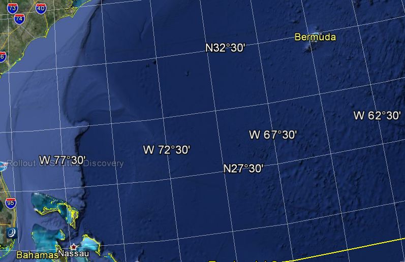
Seems huge and at the same longitude of Giza Pyramids in Egypt, but it lies on Ocean sea floor in the Bermuda Triangle, just off coasts of Georgia and
Florida. After reading an interesting thread www.abovetopsecret.com..., on an archological discovery of the
remains of an ancient walled city which predates the construction of Egypt's pyramids off the Georgia coast, I dug up a bit nearby the
Atlantic East Coast
Using GLORIA a long-range sidescan sonar system GLORIA (Geological LOng-Range Inclined Asdic)
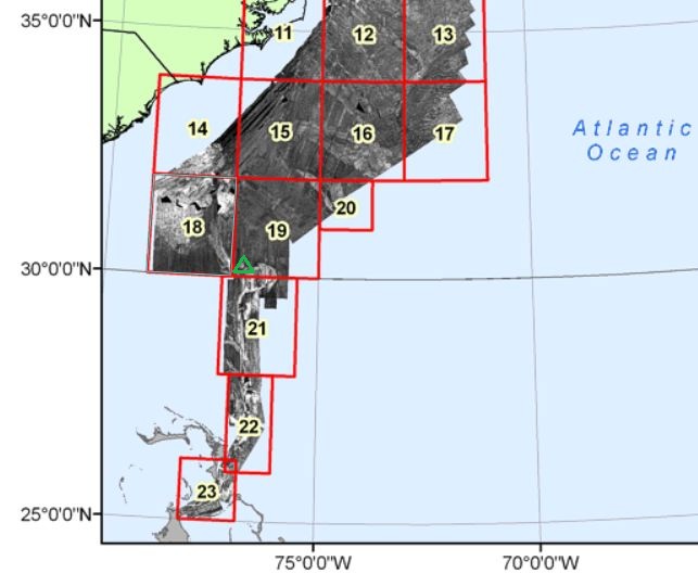
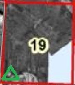
On "19" Box Image
On the bottom left, I found this...
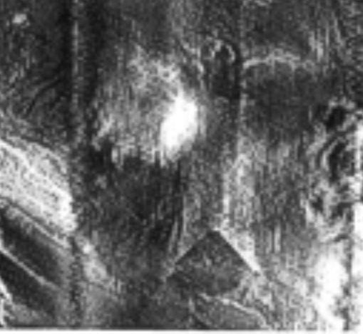
Something like a Pyramid
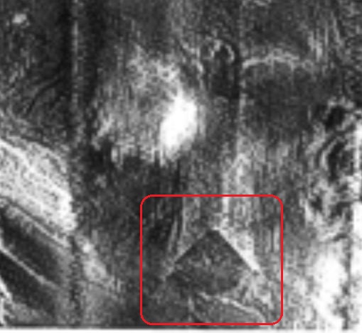
It's awesome, but, of course, this deserve a more accurate and deeper analisys.
To Mods: feel free to move in appropriate forum.
Thx.
Using GLORIA a long-range sidescan sonar system GLORIA (Geological LOng-Range Inclined Asdic)
On "19" Box Image
On the bottom left, I found this...
Something like a Pyramid
It's awesome, but, of course, this deserve a more accurate and deeper analisys.
To Mods: feel free to move in appropriate forum.
Thx.
edit on 31-1-2012 by Arken because: (no reason given)
I always like your threads Arken.
But surely somebody would have found this before now ? How deep is the area in question I find it very hard to tell from the pics what it could be.
I will do some more digging and get back to you but this could explain some of the strange going ons that happen in this area maybe energy been released by the object.
reply to post by Arken
Cool find.
I'm going to, however, speculate this may be an imaging artifact.
Would be quite very cool were it genuine.
10,000 years ago, end of last ice age, sea levels were near 400ft lower than they are now.
Between then and now, within that 400ft range, depending on when and what the sea levels were at time, lots of interesting, now lost stuff may very well be laying about, just waiting rediscovery.
Unfortunately, underwater archaeology is so costly, there's not much funding for anything, especially anything that might go against established paradigms.
Originally posted by judus
I always like your threads Arken.
But surely somebody would have found this before now ? How deep is the area in question I find it very hard to tell from the pics what it could be.
I will do some more digging and get back to you but this could explain some of the strange going ons that happen in this area maybe energy been released by the object.
Thank you.
I don't know, but surely this "pyramidal structure" deserve more deeper analysys.
Originally posted by LeLeu
wow! Nice one
Do you have any coordinates?
Roughly 30° N, 77° W
reply to post by Arken
Since those pictures are taken from above, if that was truely a pyramid, it would not look like that from above... It would look more like a square. What is more probable is some kind of lens flare effect like seen on many space pictures, where some of them lensflares are also formed exactly like a triangle like that. However it could just as well be some photoshopping at work as well.
Since those pictures are taken from above, if that was truely a pyramid, it would not look like that from above... It would look more like a square. What is more probable is some kind of lens flare effect like seen on many space pictures, where some of them lensflares are also formed exactly like a triangle like that. However it could just as well be some photoshopping at work as well.
Wowzers. Interesting find. I noticed it said that the image was produced using a "side scan" sonar, so maybe this has distorted the data to look
like a pyramid. Even if its a triangular cut in the sea floor, or 2 converging pieces of something though, it's still big and produces straight
edges. It's very bizarre if it is a real feature on the ocean bed though eh. Great find
reply to post by NeoVain
Who "photoshopped" this radar image?
However it could just as well be some photoshopping at work as well
Who "photoshopped" this radar image?
Originally posted by NeoVain
reply to post by Arken
Since those pictures are taken from above, if that was truely a pyramid, it would not look like that from above... It would look more like a square. What is more probable is some kind of lens flare effect like seen on many space pictures, where some of them lensflares are also formed exactly like a triangle like that. However it could just as well be some photoshopping at work as well.
did you see where it said it came form a side scan sonar system? side.. doesnt equal above..
edit on 31-1-2012 by Myendica because: (no
reason given)
Originally posted by diamondsmith
reply to post by Arken
Nice find,could be there before the Flood?
If it is a man made pyramid... for sure.
Like Yonaguni Shima in Japan.
Very cool spot Arken, thanks.
As i said in that same thread, sea levels around 5500 BC were 100m lower than today. Most of our past will be buried under tonnes of sediment on the sea bed and until we discover and develop new ways to explore these places, we will still be ignorant about much of our own history.
We know man was capable of crossing oceans in the Paleolithic - how did the Aborigines get to Australia otherwise? Plus the recent discovery of trawling nets for deep sea fishing that date to around 40,000 years ago......
Not to mention Thor Heyerdahl and the Kon Tiki crossing......
Originally posted by Myendica
Originally posted by NeoVain
reply to post by Arken
Since those pictures are taken from above, if that was truely a pyramid, it would not look like that from above... It would look more like a square. What is more probable is some kind of lens flare effect like seen on many space pictures, where some of them lensflares are also formed exactly like a triangle like that. However it could just as well be some photoshopping at work as well.
did you see where it said it came form a side scan sonar system? side.. doesnt equal above..edit on 31-1-2012 by Myendica because: (no reason given)
Sidescan is just a name, it is still performed from above.
Now as you can see, it would pretty much have to be situated at the very edge of the range of this system to give a triangular picture like the one in the OP, but as this scanning is continuous, it would change as soon as the inclination of the scan changed, giving a different picture.
Not saying it is impossible, just highly unlikely, since such a find, if legit, would surely have sparked further interest demanding an actual investigation into the matter unless it was already explained away, as a lens flare for example.
edit on 31-1-2012 by NeoVain because: (no
reason given)
reply to post by NeoVain
Or a "swamp gas", or a "weather balloon"...
As I said in the Opening Post: This anomaly deserve a more accurate and deeper analysys.
This is how GLORIA, Geological LOng-Range Inclined Asdic, works
coastalmap.marine.usgs.gov...
as a lens flare for example.
Or a "swamp gas", or a "weather balloon"...
As I said in the Opening Post: This anomaly deserve a more accurate and deeper analysys.
This is how GLORIA, Geological LOng-Range Inclined Asdic, works
coastalmap.marine.usgs.gov...
GLORIA creates images (sonographs) that are a record of the acoustic backscatter from the ocean floor. These images are created by transmitting a series of sound pulses and recording their echoes from the sea floor as the collecting ship moves along a set course. The sound source and receivers are built into a "fish" that is towed about 200 meters behind a ship. This electronic mapping system emits a signal (pulse) every 30 seconds. The pulse travels through the ocean to the bottom where it is partly absorbed and partly reflected by the seafloor. The returned signal is then recorded by shipboard computers. In general, the returned signal is recorded in a range of 0-255 with strong returns recorded as higher values and weak returns recorded as lower values. The darkness or brightness of a feature or an area on the sonographs and completed mosaics is therefore a function of how much sound is reflected from the seafloor.
The USGS selected sidescan sonar as the mapping tool because it could be used to obtain information on geologic processes. The intensity of the back-scattered sound from the seafloor is a function of the gradient or slope of the seafloor, of the surface roughness, and of the sediment characteristics such as texture. Another advantage to the GLORIA system was because the system provides information from a swath of seafloor, large areas could be mapped quickly. More detailed information and specifications of the GLORIA-II system is available from Somers and others (1978). The GLORIA imagery provides the first broad-scale view of sea-floor features and the effects of sedimentary processes that have been unknown or poorly known until recently. These data are a unique set of basic information that will support many future studies by government, academic, and industry workers.
edit on 31-1-2012 by Arken because: (no reason given)
Originally posted by Arken
reply to post by NeoVain
However it could just as well be some photoshopping at work as well
Who "photoshopped" this radar image?
Who? Really? How should i know who.
How could it be done though? That is a far better question.
Not hard...
But i am more leaning towards it being a lens flare kind of effect, like this one below that was already debunked by phage.
edit on 31-1-2012 by NeoVain because: (no reason given)
reply to post by Arken
I can agree with that, but i don´t think we will get anywhere without actually getting on a submarine and physically go over there though. And considering similar lens-flares in the past, i wouldn´t get my hopes up.
Still, i would be the first one to volunteer to climb aboard that submarine, if there was an opening
As I said in the Opening Post: This anomaly deserve a more accurate and deeper analysys.
I can agree with that, but i don´t think we will get anywhere without actually getting on a submarine and physically go over there though. And considering similar lens-flares in the past, i wouldn´t get my hopes up.
Still, i would be the first one to volunteer to climb aboard that submarine, if there was an opening
reply to post by NeoVain
except the purpose of sonar is to find things, and for topography reasons, so they wouldnt ignore a triangular sided mountainous form. And because it formed a triangle, and appears like a pyramid, that it then couldnt be a pyramid? Sonar wouldnt keep blasting the ground with sound if they wanted to map it flat.
except the purpose of sonar is to find things, and for topography reasons, so they wouldnt ignore a triangular sided mountainous form. And because it formed a triangle, and appears like a pyramid, that it then couldnt be a pyramid? Sonar wouldnt keep blasting the ground with sound if they wanted to map it flat.
new topics
-
Any one suspicious of fever promotions events, major investor Goldman Sachs card only.
The Gray Area: 47 minutes ago -
God's Righteousness is Greater than Our Wrath
Religion, Faith, And Theology: 5 hours ago -
Electrical tricks for saving money
Education and Media: 8 hours ago -
VP's Secret Service agent brawls with other agents at Andrews
Mainstream News: 9 hours ago -
Sunak spinning the sickness figures
Other Current Events: 10 hours ago -
Nearly 70% Of Americans Want Talks To End War In Ukraine
Political Issues: 10 hours ago
top topics
-
VP's Secret Service agent brawls with other agents at Andrews
Mainstream News: 9 hours ago, 9 flags -
Cats Used as Live Bait to Train Ferocious Pitbulls in Illegal NYC Dogfighting
Social Issues and Civil Unrest: 13 hours ago, 8 flags -
Electrical tricks for saving money
Education and Media: 8 hours ago, 4 flags -
HORRIBLE !! Russian Soldier Drinking Own Urine To Survive In Battle
World War Three: 17 hours ago, 3 flags -
Sunak spinning the sickness figures
Other Current Events: 10 hours ago, 3 flags -
Nearly 70% Of Americans Want Talks To End War In Ukraine
Political Issues: 10 hours ago, 3 flags -
Late Night with the Devil - a really good unusual modern horror film.
Movies: 12 hours ago, 2 flags -
The Good News According to Jesus - Episode 1
Religion, Faith, And Theology: 15 hours ago, 1 flags -
Any one suspicious of fever promotions events, major investor Goldman Sachs card only.
The Gray Area: 47 minutes ago, 1 flags -
God's Righteousness is Greater than Our Wrath
Religion, Faith, And Theology: 5 hours ago, 0 flags
active topics
-
HORRIBLE !! Russian Soldier Drinking Own Urine To Survive In Battle
World War Three • 35 • : twistedpuppy -
VP's Secret Service agent brawls with other agents at Andrews
Mainstream News • 42 • : 38181 -
Nearly 70% Of Americans Want Talks To End War In Ukraine
Political Issues • 15 • : Consvoli -
SETI chief says US has no evidence for alien technology. 'And we never have'
Aliens and UFOs • 55 • : Consvoli -
God's Righteousness is Greater than Our Wrath
Religion, Faith, And Theology • 4 • : randomuser2034 -
The Acronym Game .. Pt.3
General Chit Chat • 7746 • : bally001 -
Any one suspicious of fever promotions events, major investor Goldman Sachs card only.
The Gray Area • 1 • : BeyondKnowledge3 -
Terrifying Encounters With The Black Eyed Kids
Paranormal Studies • 75 • : FlyersFan -
Russia Ukraine Update Thread - part 3
World War Three • 5728 • : F2d5thCavv2 -
Electrical tricks for saving money
Education and Media • 5 • : BeyondKnowledge3