It looks like you're using an Ad Blocker.
Please white-list or disable AboveTopSecret.com in your ad-blocking tool.
Thank you.
Some features of ATS will be disabled while you continue to use an ad-blocker.

Quake Watch 2012
page: 75share:
Magnitude mb 5.2
Region NEAR EAST COAST OF HONSHU, JAPAN
Date time 2012-03-14 21:38:56.0 UTC
Location 35.55 N ; 141.68 E
Depth 35 km
Distances 173 km E Tokyo (pop 8,336,599 ; local time 06:38:56.3 2012-03-15)
126 km E Narita (pop 100,641 ; local time 06:38:56.3 2012-03-15)
82 km E Choshi (pop 75,650 ; local time 06:38:56.3 2012-03-15)
EMSC
PuterMan, I'm new to this quake subject, and wonder if you would give your opinion. With the latest quakes in a short amount of time, are you
worried that Japan may see another massive quake soon? Or is this just stress relieving, and not to worry too much?
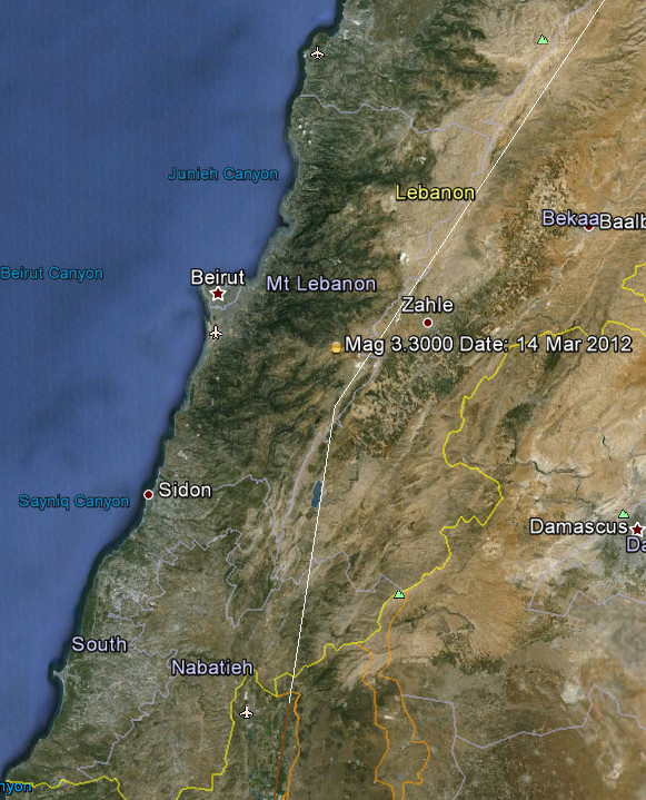
Interesting one: Location
EMSC
Magnitude Mc 3.3
Region LEBANON - SYRIA REGION
Date time 2012-03-14 20:25:53.2 UTC
Location 33.81 N ; 35.73 E
Depth 7 km
Distances 23 km E Bayrut (pop 1,251,739 ; local time 22:25:53.2 2012-03-14)
11 km E 'alayh (pop 27,233 ; local time 22:25:53.2 2012-03-14)
EMSC
Originally posted by jb1958
PuterMan, I'm new to this quake subject, and wonder if you would give your opinion. With the latest quakes in a short amount of time, are you worried that Japan may see another massive quake soon? Or is this just stress relieving, and not to worry too much?
This particular area is not quite the same as the Honshu quake being more towards Hokkaido. Whilst the 9.1 encompassed that area I believe that this particular batch may not be directly related to the 9.1
Having said that however this seems to be exhibiting a reasonably normal main shock/after shocks sequence so no I am not thinking this will lead to anything bigger.
As I said earlier in the day there could be what would be termed as a larger quake in the region, up to maybe a mag 8, but that is small fry compared to the 9.1
reply to post by Hellas
No I am afraid I don't. Nowhere near Homs and too far inland Lebanon.
Actually it is right on the continental convergent boundary that runs up through there. I guess we just don't see so many there that when we do it looks odd.
No I am afraid I don't. Nowhere near Homs and too far inland Lebanon.
Actually it is right on the continental convergent boundary that runs up through there. I guess we just don't see so many there that when we do it looks odd.
UPDATE to post by PuterMan
Down to 6.2 from 6.4. Details still different from EMSC but getting closer.
Date/Time UTC,Latitude,Longitude,Magnitude,Depth(Km),Location
2012-03-14 21:13:11, -5.642, 151.025, 6.2, 47.8, New Britain Region. P.N.G
Down to 6.2 from 6.4. Details still different from EMSC but getting closer.
Magnitude Mw 6.4
Region NEW BRITAIN REGION, P.N.G.
Date time 2012-03-14 21:13:14.0 UTC
Location 5.70 S ; 151.00 E
Depth 80 km
Distances 2429 km NW Brisbane (pop 1,843,392 ; local time 07:13:14.9 2012-03-15)
97 km E Kimbe (pop 18,847 ; local time 07:13:14.9 2012-03-15)
595 km NE Port moresby (pop 283,733 ; local time 07:13:14.9 2012-03-15)
Source parameters not yet reviewed by a seismologist
Sorry if it's been posted...didn't spot it
Rainbows
Jane
reply to post by Anmarie96
Glad someone caught that one
I had gone to work by then.
Geonet had 5.418LML a bit further out to sea than where USGS had it
and a possible 4.381 aftershock on the opposite side of the Caswell Spur
Not sure what Geonet are playing at, there were many Mag 1's on the Geonet Rapid this morning but there is no sign of them on the magma data download.
I have debunked the "there is a 5+ coming to NZ soon because the daily numbers have dropped off to less than 10 /day" myself, but this one seems to fit the theory, with the two previous days only having 6 quakes each day for the whole country. I thought it yesterday, but didn't say anything as its not consistent enough to be right every time.
Glad someone caught that one
I had gone to work by then.
Geonet had 5.418LML a bit further out to sea than where USGS had it
and a possible 4.381 aftershock on the opposite side of the Caswell Spur
Not sure what Geonet are playing at, there were many Mag 1's on the Geonet Rapid this morning but there is no sign of them on the magma data download.
edit on 15-3-2012 by muzzy because: (no reason given)
I have debunked the "there is a 5+ coming to NZ soon because the daily numbers have dropped off to less than 10 /day" myself, but this one seems to fit the theory, with the two previous days only having 6 quakes each day for the whole country. I thought it yesterday, but didn't say anything as its not consistent enough to be right every time.
edit on 15-3-2012 by muzzy because: (no reason given)
Another 5+ off Fiordland
www.geonet.org.nz...
USGS short changing again with the conversion to mb
neic.usgs.gov...
If you look at LISS SNZO you can see the traces of this and the 5.428ML yesterday are virtually identical
Reference Number 3674602
Universal Time March 15 2012 at 11:15
NZ Daylight Time Friday, March 16 2012 at 0:15 am
Latitude, Longitude 45.11°S, 166.48°E
Focal Depth 12 km
Richter magnitude 5.2 (5.12ML)
Region Tasman Basin
Location
100 km west of Te Anau
120 km west of Milford Sound
210 km north-west of Invercargill
330 km west of Dunedin
www.geonet.org.nz...
USGS short changing again with the conversion to mb
15 MAR 2012 ( 75) ot = 11:15:20.2 OFF W. COAST OF S. ISLAND, N.Z.
lat = -45.183 +/- 9.1
lon = 166.718 +/- 7.2 MAGNITUDE 4.6 (mb)
dep = 9.9 +/- 1.8
154 km (96 miles) W of Queenstown, New Zealand
186 km (115 miles) NW of Invercargill, New Zealand
307 km (191 miles) WNW of Dunedin, New Zealand
784 km (487 miles) SW of WELLINGTON, New Zealand
neic.usgs.gov...
If you look at LISS SNZO you can see the traces of this and the 5.428ML yesterday are virtually identical
Magnitude mb 4.7
Region NORTH OF SVALBARD
Date time 2012-03-15 15:45:17.0 UTC
Location 82.15 N ; 6.42 W
Depth 10 km
Distances 2638 km NW Stockholm (pop 1,253,309 ; local time 16:45:17.9 2012-03-15)
1752 km NW Murmansk (pop 319,263 ; local time 18:45:17.9 2012-03-15)
1518 km NW Tromsø (pop 52,436 ; local time 16:45:17.9 2012-03-15)
EMSC
Magnitude mb 5.2
Region NEAR S. COAST OF HONSHU, JAPAN
Date time 2012-03-15 19:20:15.8 UTC
Location 35.83 N ; 139.70 E
Depth 80 km
Distances 7 km SE Saitama (pop 1,077,730 ; local time 04:20:15.8 2012-03-16)
2 km NE Toda (pop 118,731 ; local time 04:20:15.8 2012-03-16)
3 km SE Warabi (pop 69,646 ; local time 04:20:15.8 2012-03-16)
EMSC
Magnitude mb 5.5
Region KURIL ISLANDS
Date time 2012-03-16 00:38:06.0 UTC
Location 49.29 N ; 156.09 E
Depth 30 km
Distances 1327 km NE Sapporo (pop 1,883,027 ; local time 09:38:06.8 2012-03-16)
451 km SW Petropavlovsk-kamchatskiy (pop 187,282 ; local time 12:38:06.8 2012-03-16)
456 km SW Mokhovaya, petropavlovsk-kamch (pop 22,815 ; local time 12:38:06.8 2012-03-16)
Source parameters reviewed by a seismologist
EMSC
Rainbows
Jane
source(earthquake.usgs.gov...
Magnitude 5.9
Date-Time Friday, March 16, 2012 at 07:58:06 UTC Friday, March 16, 2012 at 03:58:06 PM at epicenter Time of Earthquake in other Time Zones
Location 9.995°N, 125.600°E Depth 44.3 km (27.5 miles)
Region MINDANAO, PHILIPPINES
Distances 25 km (15 miles) NNE of Surigao, Mindanao, Philippines 115 km (71 miles) N of Butuan, Mindanao, Philippines 116 km (72 miles) S of Guiuan, Samar, Philippines 716 km (444 miles) SE of MANILA, Philippines Location Uncertainty horizontal +/- 15.7 km (9.8 miles); depth +/- 8.3 km (5.2 miles)
Parameters NST=203, Nph=206, Dmin=323.9 km, Rmss=0.86 sec, Gp= 47°, M-type=regional moment magnitude (Mw), Version=8
Something I haven't done before is 90 days NZ quakes, mainly because there are so many quakes the Google Maps usually freaks out and can't cope with
the number of icons.
See how they load for you today, I got them to all load on just now.
interactive 90 days
I wanted to see if I could see any trends, it seemed that activity has moved away from Christchurch over to offshore Fiordland lately. On the interactive map you can click or unclick each 30 day period to see the changes, or hot spots, zoom in and out etc
There was one day (13th March UTC) where no events were recorded in the preliminary data for Christchurch.
Which raises the question " are we done there yet?"
I notice that of the few quakes they are still getting many are not being reported as Felt, is everyone down there " over it"?
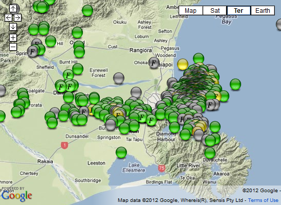
For those who are on Broadband the interactive map probably won't load so here is the Christchurch last 90 days, goes back to include the 6.0 on 23/12/2011 at South New Brighton
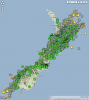
and heres NZ for the last 90 days (thumbnail, click for larger image)
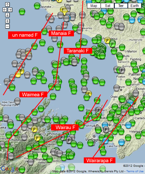
Also quite handy to see the Faults in my "Bay", some are obvious, some are not so, looks like some may join up to be continuous.
eg the Taranaki Fault looks like it keeps on going south, and the Manaia F and Taranaki F seems to have another cross fault at the south end, which may be an extension of the Wanganui Basin Fault Zone.
That "unnamed Fault" probably does have a name, just can't think of it right now, thats where the bigger quakes seem to happen in my area, incl a couple of 6's in the past 16 years.
See how they load for you today, I got them to all load on just now.
interactive 90 days
I wanted to see if I could see any trends, it seemed that activity has moved away from Christchurch over to offshore Fiordland lately. On the interactive map you can click or unclick each 30 day period to see the changes, or hot spots, zoom in and out etc
There was one day (13th March UTC) where no events were recorded in the preliminary data for Christchurch.
Which raises the question " are we done there yet?"
I notice that of the few quakes they are still getting many are not being reported as Felt, is everyone down there " over it"?
For those who are on Broadband the interactive map probably won't load so here is the Christchurch last 90 days, goes back to include the 6.0 on 23/12/2011 at South New Brighton
and heres NZ for the last 90 days (thumbnail, click for larger image)

Also quite handy to see the Faults in my "Bay", some are obvious, some are not so, looks like some may join up to be continuous.
eg the Taranaki Fault looks like it keeps on going south, and the Manaia F and Taranaki F seems to have another cross fault at the south end, which may be an extension of the Wanganui Basin Fault Zone.
That "unnamed Fault" probably does have a name, just can't think of it right now, thats where the bigger quakes seem to happen in my area, incl a couple of 6's in the past 16 years.
edit on 16-3-2012 by muzzy because: (no reason given)
reply to post by Hellas
Thats a pretty bigun for the suburbs of Rotorua, deep though, no felt reports
Officially 5.01ML, not a mag 4.9 rounded up.
Thats a pretty bigun for the suburbs of Rotorua, deep though, no felt reports
Officially 5.01ML, not a mag 4.9 rounded up.
Beer getting shaken up?
Location in Google Maps
Derived from Data Source: USGS
Powered by QVSData
Magnitude 5.2 Carlsberg Ridge
Location in Google Maps
- Date-Time: Saturday, March 17, 2012 at 15:16:24 UTC
Saturday, March 17, 2012 at 07:16:24 PM at epicenter
- Location: 3.862°N, 63.387°E
- Depth: 10 km (6.2 miles)
- Region: CARLSBERG RIDGE
- Distances:
1124 km [698 miles] W of MALE, Maldives1188 km [738 miles] WNW of Hithadhoo, Maldives1258 km [781 miles] SW of Kavaratti, Lakshadweep, India3011 km [1870 miles] E of NAIROBI, Kenya
- Location Uncertainty: horizontal +/- 20.6 km (12.8 miles); depth +/- 2.8 km (1.7 miles)
- Parameters: NST= 48, Nph= 48, Dmin=>999 km, Rmss=1.38 sec, Gp=101°,M-type=body wave magnitude (Mb), Version=5
- Source: Magnitude: USGS NEIC (WDCS-D)Location: USGS NEIC (WDCS-D)
- Event ID: usb0008izd
Derived from Data Source: USGS
Powered by QVSData
reply to post by PuterMan
EMSC has 3 logged for that region and they definitely look individual by the locations and times - unusual to see 3 together in such quick succession imho for that region.
Make that 4 including this one just in - quite a ...dare I say it ? Swarm !
www.emsc-csem.org...
EMSC has 3 logged for that region and they definitely look individual by the locations and times - unusual to see 3 together in such quick succession imho for that region.
Make that 4 including this one just in - quite a ...dare I say it ? Swarm !
www.emsc-csem.org...
edit on 17-3-2012 by slidingdoor because: to add info
The Stargate Is Opening
Location in Google Maps
Derived from Data Source: USGS
Powered by QVSData
Magnitude 5.5 Carlsberg Ridge
Location in Google Maps
- Date-Time: Saturday, March 17, 2012 at 17:00:57 UTC
Saturday, March 17, 2012 at 09:00:57 PM at epicenter
- Location: 3.898°N, 63.403°E
- Depth: 9.7 km (6.0 miles)
- Region: CARLSBERG RIDGE
- Distances:
1117 km [694 miles] W [269°] from MALE, Maldives
1568 km [974 miles] WSW [246°] from Cochin, Kerala, India
- Location Uncertainty: horizontal +/- 16.1 km (10.0 miles); depth +/- 4.9 km (3.0 miles)
- Parameters: NST=193, Nph=193, Dmin=>999 km, Rmss=1.29 sec, Gp= 50°,M-type=body wave magnitude (Mb), Version=5
- Source: Magnitude: USGS NEIC (WDCS-D)Location: USGS NEIC (WDCS-D)
- Event ID: usb0008j0s
Derived from Data Source: USGS
Powered by QVSData
new topics
-
Israeli strikes on southern Gaza city of Rafah kill 22, mostly children, as US advances aid package
Middle East Issues: 1 hours ago -
Really Unexplained
Paranormal Studies: 6 hours ago -
The Vaccine Injured
Medical Issues & Conspiracies: 6 hours ago -
Leading Surgeon from Al-Shifa Hospital Dies in Israeli Custody
Middle East Issues: 9 hours ago
top topics
-
Zionists of ATS assemble
Political Issues: 13 hours ago, 11 flags -
Leading Surgeon from Al-Shifa Hospital Dies in Israeli Custody
Middle East Issues: 9 hours ago, 5 flags -
The Vaccine Injured
Medical Issues & Conspiracies: 6 hours ago, 4 flags -
Really Unexplained
Paranormal Studies: 6 hours ago, 4 flags -
Israeli strikes on southern Gaza city of Rafah kill 22, mostly children, as US advances aid package
Middle East Issues: 1 hours ago, 1 flags
active topics
-
Israeli strikes on southern Gaza city of Rafah kill 22, mostly children, as US advances aid package
Middle East Issues • 47 • : BernnieJGato -
Zionists of ATS assemble
Political Issues • 92 • : Degradation33 -
Really Unexplained
Paranormal Studies • 17 • : Encia22 -
Leading Surgeon from Al-Shifa Hospital Dies in Israeli Custody
Middle East Issues • 38 • : nugget1 -
Killings of Palestinian children are soaring in the West Bank.
World War Three • 181 • : nugget1 -
-@TH3WH17ERABB17- -Q- ---TIME TO SHOW THE WORLD--- -Part- --44--
Dissecting Disinformation • 799 • : Thoughtful3 -
Shocking moment four men 'try to force Jewish pedestrian into car boot' in North London
Breaking Alternative News • 85 • : 19Bones79 -
Study Finds The More Covid Vaccine Doses You Have, the More Likely You Are to Get Covid
Medical Issues & Conspiracies • 37 • : NoCorruptionAllowed -
Wounded Orangutan seen using a Plant as Medicine for the First Time
Fragile Earth • 28 • : andy06shake -
UN Estimates Rebuilding Gaza Will Cost Up To 40 Billion Dollars
Middle East Issues • 79 • : Threadbarer