It looks like you're using an Ad Blocker.
Please white-list or disable AboveTopSecret.com in your ad-blocking tool.
Thank you.
Some features of ATS will be disabled while you continue to use an ad-blocker.

Quake Watch 2012
page: 244share:
Don't think I ever saw this much yellow before!!!
Wish I knew how to do a screen shot!
earthquake.usgs.gov...
WOQ
Wish I knew how to do a screen shot!
earthquake.usgs.gov...
WOQ
reply to post by wasobservingquietly
Nothing out of the ordinary there. In fact it has been quiet which was why I was expecting a bigger one.
Now, Iceland - and this is NOT Reykjanes
Tjornes fracture zone I think, or very close by - yes it is. Possibly volcanic as it is centred off the ridge and there are several underwater volcanoes there.
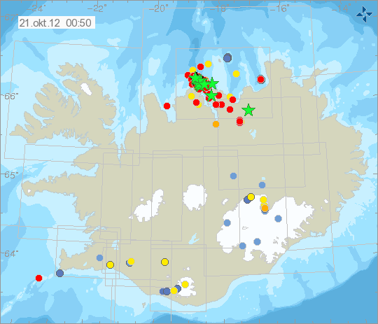

Source
©Icelandic Met Office
Nothing out of the ordinary there. In fact it has been quiet which was why I was expecting a bigger one.
Now, Iceland - and this is NOT Reykjanes
Prov,Date/Time UTC,Latitude,Longitude,Magnitude,Depth(Km),Location
emsc,2012-10-21 00:40:24, 66.252, -18.509, 3.6, 1.0, Iceland Region
emsc,2012-10-21 00:34:19, 66.324, -18.790, 4.1, 7.0, Iceland Region
emsc,2012-10-21 00:30:42, 66.304, -18.679, 3.8, 18.0, Iceland Region
emsc,2012-10-21 00:20:29, 66.287, -18.630, 4.5, 1.0, Iceland Region
emsc,2012-10-21 00:10:35, 66.346, -18.630, 4.6, 10.0, Iceland Region
emsc,2012-10-20 22:54:25, 66.273, -18.708, 3.9, 1.0, Iceland Region
emsc,2012-10-20 22:50:40, 66.394, -18.761, 3.3, 1.0, Iceland Region
Tjornes fracture zone I think, or very close by - yes it is. Possibly volcanic as it is centred off the ridge and there are several underwater volcanoes there.
Source
©Icelandic Met Office
Originally posted by wasobservingquietly
Don't think I ever saw this much yellow before!!!
Wish I knew how to do a screen shot!
earthquake.usgs.gov...
WOQ
If you are using Windows 7 using the snipping tool, just start typing snipping into the box and it should pop up!
reply to post by PuterMan
And this one:
USGS technical page for Mag 5.7 Iceland
And this one:
5.7 18km NNE of Siglufjordur, Iceland 2012-10-21 01:25:22 66.296°N 18.685°W 9.9
USGS technical page for Mag 5.7 Iceland
5.3 in King City California
I live a couple hours away and my house was shaking pretty good!
I live a couple hours away and my house was shaking pretty good!
edit on 10/21/2012 by White2098 because: (no reason given)
Originally posted by White2098
5.3 in King City California
I live a couple hours away and my house was shaking pretty good!edit on 10/21/2012 by White2098 because: (no reason given)
It must of been a good one too. Stay safe my friend.
Things are heating up
Activity soo far
Sunday October 21 2012, 07:41:16 UTC Central California 2.5 USGS
Sunday October 21 2012, 07:40:01 UTC Central California 1.9 USGS
Sunday October 21 2012, 07:37:47 UTC Central California 3.7 USGS Feed
Sunday October 21 2012, 07:28:38 UTC Southern California 1.5 USGS Feed
Sunday October 21 2012, 07:27:05 UTC Central California 1.6 USGS Feed
Sunday October 21 2012, 07:24:18 UTC Central California 1.7 USGS Feed
Sunday October 21 2012, 07:18:03 UTC Central California 3.1 USGS Feed
Sunday October 21 2012, 07:17:10 UTC Central California 1.6 USGS Feed
Sunday October 21 2012, 07:16:21 UTC Central California 1.8 USGS Feed
Sunday October 21 2012, 07:15:48 UTC Central California 2.2 USGS Feed
Sunday October 21 2012, 07:14:35 UTC Central California 1.8 USGS Feed
Sunday October 21 2012, 07:14:02 UTC Central California 1.9 USGS Feed
Sunday October 21 2012, 07:13:17 UTC Central California 1.5 USGS Feed
Sunday October 21 2012, 07:10:24 UTC Central California 2.3 USGS Feed
Sunday October 21 2012, 07:06:44 UTC Central California 2.1 USGS Feed
Sunday October 21 2012, 07:06:15 UTC Central California 2.2 USGS Feed
Sunday October 21 2012, 07:05:10 UTC Central California 2.0 USGS Feed
Sunday October 21 2012, 07:04:24 UTC Central California 2.2 USGS Feed
Sunday October 21 2012, 07:03:38 UTC Central California 1.9 USGS Feed
Sunday October 21 2012, 07:02:37 UTC Central California 1.9 USGS Feed
Sunday October 21 2012, 07:01:48 UTC Central California 2.2 USGS Feed
Sunday October 21 2012, 06:55:09 UTC Central California 5.3 USGS Feed
edit on 7/30/2012 by dreamfox1 because: Sunday October 21 2012, 07:28:38 UTC 3 minutes ago Southern California 1.5 8.5 USGS Feed
Detail
edit on 7/30/2012 by dreamfox1 because: Sunday October 21 2012, 07:37:47 UTC 4 minutes ago Central California 3.7 9.5
USGS Feed Detail
edit on 7/30/2012 by dreamfox1 because: (no reason given)
reply to post by White2098
I remember driving up that way on a visit to the USA in 2000...very scenic trip.
A 5.3 would have ROCKED pretty good! Hope it's a one-off for y'all!
I remember driving up that way on a visit to the USA in 2000...very scenic trip.
A 5.3 would have ROCKED pretty good! Hope it's a one-off for y'all!
2012-10-21 06:55:09 UTC
2012-10-20 23:55:09 UTC-07:00 at epicenter
2012-10-21 02:55:09 UTC-04:00 system time
Location
36.311°N 120.856°W depth=9.4km (5.8mi)
Nearby Cities
26km (16mi) ENE of King City, California
34km (21mi) E of Greenfield, California
44km (27mi) ESE of Soledad, California
48km (30mi) WNW of Coalinga, California
258km (160mi) SSE of Sacramento, California
Still updating as aftershocks keep on coming
Active quake cam here abclocal.go.com...
Activity soo far
Sunday October 21 2012, 08:36:08 UTC Central California 1.9 USGS Feed
Sunday October 21 2012, 08:35:19 UTC Central California 2.2 USGS Feed
Sunday October 21 2012, 08:33:29 UTC Central California 1.6 USGS Feed
Sunday October 21 2012, 08:32:39 UTC Central California 1.4 USGS Feed
Sunday October 21 2012, 08:30:24 UTC Central California 1.9 USGS Feed
Sunday October 21 2012, 08:28:03 UTC Central California 1.3 USGS Feed
Sunday October 21 2012, 08:25:08 UTC Central California 2.4 USGS Feed
Sunday October 21 2012, 08:23:37 UTC Central California 2.0 USGS Feed
Sunday October 21 2012, 08:22:21 UTC Central California 2.0 USGS Feed
Sunday October 21 2012, 08:17:05 UTC Central California 1.9 USGS Feed
Sunday October 21 2012, 08:07:18 UTC Central California 1.5 USGS Feed
Sunday October 21 2012, 08:06:36 UTC Central California 1.8 USGS Feed
Sunday October 21 2012, 08:06:28 UTC Central California 2.3 USGS Feed
Sunday October 21 2012, 07:51:33 UTC Central California 3.3 USGS Feed
Sunday October 21 2012, 07:46:12 UTC Central California 2.1 USGS Feed
Sunday October 21 2012, 07:41:16 UTC Central California 2.5 USGS Feed
Sunday October 21 2012, 07:40:01 UTC Central California 1.9 USGS Feed
Sunday October 21 2012, 07:37:47 UTC Central California 3.7 USGS Feed
Sunday October 21 2012, 07:27:05 UTC Central California 1.6 USGS Feed
Sunday October 21 2012, 07:24:18 UTC Central California 1.7 USGS Feed
Sunday October 21 2012, 07:18:03 UTC Central California 3.1 USGS Feed
Sunday October 21 2012, 07:17:10 UTC Central California 1.6 USGS Feed
Sunday October 21 2012, 07:16:21 UTC Central California 1.8 USGS Feed
Sunday October 21 2012, 07:15:48 UTC Central California 2.2 USGS Feed
Sunday October 21 2012, 07:14:35 UTC Central California 1.8 USGS Feed
Sunday October 21 2012, 07:14:02 UTC Central California 1.9 USGS Feed
Sunday October 21 2012, 07:13:17 UTC Central California 1.5 USGS Feed
Sunday October 21 2012, 07:10:24 UTC Central California 2.3 USGS Feed
Sunday October 21 2012, 07:06:44 UTC Central California 2.1 USGS Feed
Sunday October 21 2012, 07:06:15 UTC Central California 2.2 USGS Feed
Sunday October 21 2012, 07:05:10 UTC Central California 2.0 USGS Feed
Sunday October 21 2012, 07:04:24 UTC Central California 2.2 USGS Feed
Sunday October 21 2012, 07:03:38 UTC Central California 1.9 USGS Feed
Sunday October 21 2012, 07:02:37 UTC Central California 1.9 USGS Feed
Sunday October 21 2012, 07:01:48 UTC Central California 2.2 USGS Feed
Sunday October 21 2012, 06:55:09 UTC Central California 5.3 USGS Feed
Uptates ended for now time for bed Zzz Zzz
edit on 7/30/2012 by dreamfox1 because: Zzz Zzz
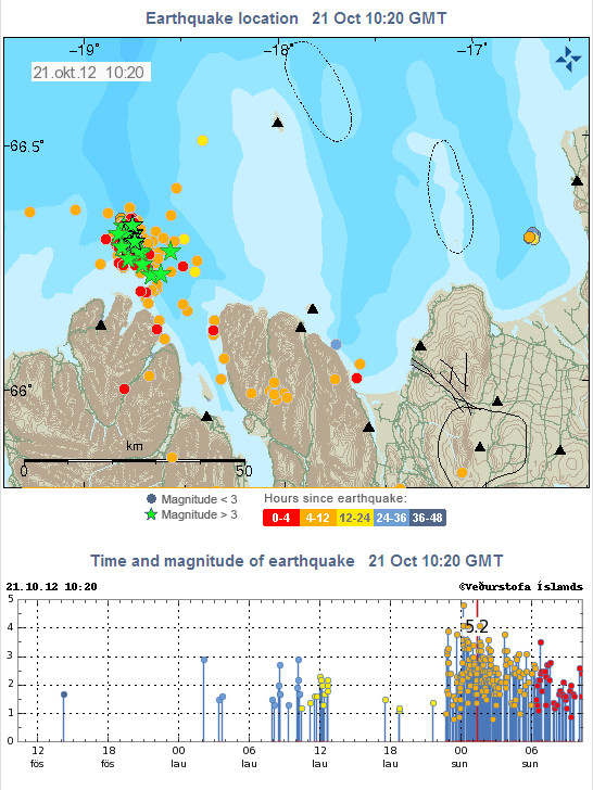
Heavy activity at Tjörnes Fracture Zone in Iceland. Largest earthquake was 4,8 magnitude. There has been massive amount of earthquakes during last 48
hours: 374. 48 of them were more than magnitude 3.
I have never seen such high activity in TFZ. That area is full of volcanoes, this high activity can cause changes in them, triggering eruptions.

I have never seen such high activity in TFZ. That area is full of volcanoes, this high activity can cause changes in them, triggering eruptions.
edit on 21-10-2012 by Thebel because: (no reason given)
I rarely post, but this seemingly not-unusually sized CA 5.3 quake was felt strongly by us, despite the distance from us, and many other
Californians:
M5.3 - 26km ENE of King City, California
M5.3 - 26km ENE of King City, California
edit on 10/21/2012 by chupacobra because: deleted external link to map contained within enclosed link.
reply to post by Thebel
Actually it was 5.2 according to the Icelandic Met Office. (And EMSC)
©Icelandic Met Office (Veðurstofa Íslands - Bústaðavegi 9, 150 Reykjavík)
This also apparently started at the end of September based on this report
So despite my musing in my earlier post about this above it seems it is tectonic and not volcanic. The very shallow depths of many of these were making me think volcanic.
List todate
This made me get off my backside and get on with my uploads of Icelandic quakes to YT which I last did in May!!
Here is September 2012 so you can see the activity in the area we are concerned with.
I find You Tube very messy and unordered so I have assembled my Iceland Videos starting on this page in a more ordered fashion. I shall add earthquake lists to this later in a similar fashion to the Cascades pages on the blog.
Actually it was 5.2 according to the Icelandic Met Office. (And EMSC)
©Icelandic Met Office (Veðurstofa Íslands - Bústaðavegi 9, 150 Reykjavík)
This also apparently started at the end of September based on this report
Earthquakes are not uncommon in this area, comparable earthquake sequences have occurred in 1996 and 2004 around the same location as the present one. They lasted for several days and earthquakes above M4 were measured.
So despite my musing in my earlier post about this above it seems it is tectonic and not volcanic. The very shallow depths of many of these were making me think volcanic.
List todate
Prov,Date/Time UTC,Latitude,Longitude,Magnitude,Depth(Km),Location
emsc,2012-10-21 10:26:27, 66.251, -18.657, 3.7, 1.0, Iceland Region
emsc,2012-10-21 06:46:06, 66.276, -18.764, 3.5, 1.0, Iceland Region
emsc,2012-10-21 03:43:23, 66.359, -18.623, 4.4, 12.0, Iceland Region
emsc,2012-10-21 02:32:11, 66.276, -18.722, 3.3, 1.0, Iceland Region
emsc,2012-10-21 02:20:01, 66.279, -18.561, 3.4, 1.0, Iceland Region
emsc,2012-10-21 02:05:07, 66.309, -18.721, 3.7, 3.0, Iceland Region
emsc,2012-10-21 01:42:21, 66.205, -18.631, 3.4, 1.0, Iceland Region
emsc,2012-10-21 01:40:14, 66.311, -18.718, 3.5, 1.0, Iceland Region
emsc,2012-10-21 01:34:07, 66.275, -18.551, 3.5, 1.0, Iceland Region
emsc,2012-10-21 01:25:22, 66.182, -19.259, 5.2, 10.0, Iceland Region
emsc,2012-10-21 01:03:48, 65.912, -18.199, 3.9, 5.0, Iceland
emsc,2012-10-21 00:40:23, 66.257, -18.680, 3.7, 1.0, Iceland Region
emsc,2012-10-21 00:34:19, 66.324, -18.790, 4.1, 7.0, Iceland Region
emsc,2012-10-21 00:30:42, 66.304, -18.679, 3.8, 18.0, Iceland Region
emsc,2012-10-21 00:20:29, 66.287, -18.630, 4.5, 1.0, Iceland Region
emsc,2012-10-21 00:10:28, 66.402, -20.520, 4.8, 2.0, Iceland Region
emsc,2012-10-20 22:54:25, 66.273, -18.708, 3.9, 1.0, Iceland Region
emsc,2012-10-20 22:50:40, 66.394, -18.761, 3.3, 1.0, Iceland Region
This made me get off my backside and get on with my uploads of Icelandic quakes to YT which I last did in May!!
Here is September 2012 so you can see the activity in the area we are concerned with.
I find You Tube very messy and unordered so I have assembled my Iceland Videos starting on this page in a more ordered fashion. I shall add earthquake lists to this later in a similar fashion to the Cascades pages on the blog.
edit on 21/10/2012 by PuterMan because: (no reason given)
reply to post by Olivine
I hadn't spotted the USGS one as I tend to use EMSC for Iceland. I note Geofon has this at 5.6 as well.
EMSC is 5.2 mb as also Iceland say, so I wonder if they are using mb as well? 5.2 Mw is ~5.58 Mw so it would seem they are all singing from the same hymn sheet.
Looking at one of their weekly data files that I collect (and then never look at again [ yet ] )
It looks as if they use ML and 5.2 mb depending on the parameters for ML of course could be ~5.4 Mw so not that far out.
I hadn't spotted the USGS one as I tend to use EMSC for Iceland. I note Geofon has this at 5.6 as well.
EMSC is 5.2 mb as also Iceland say, so I wonder if they are using mb as well? 5.2 Mw is ~5.58 Mw so it would seem they are all singing from the same hymn sheet.
Looking at one of their weekly data files that I collect (and then never look at again [ yet ] )
Nr Dags. Timi Breidd Lengd Dypi M ML
1 20121001 000032.187 63.94799 -21.33988 6.470 0.33 -0.29
2 20121001 001523.369 66.51197 -17.57926 15.151 1.77 1.71
3 20121001 001944.621 63.96586 -21.57715 6.053 1.81 1.43
4 20121001 025942.996 66.57095 -17.78790 13.469 1.60 1.58
5 20121001 030323.671 66.52032 -17.58202 16.583 2.64 3.00
It looks as if they use ML and 5.2 mb depending on the parameters for ML of course could be ~5.4 Mw so not that far out.
edit on 21/10/2012 by PuterMan because: Grammar is a good thing if you know how to handle it. Obviously I do not and thus the correction.
At least I know how to spell it though!
I live in California, a little over an hour north of King City. From my end, it was a pretty good shake, lasted maybe 20-30 seconds. Seems like we
haven't had one in a while, atleast not any that I've felt clearly.
Originally posted by chupacobra
I rarely post, but this seemingly not-unusually sized CA 5.3 quake was felt strongly by us, despite the distance from us, and many other Californians:
M5.3 - 26km ENE of King City, California
edit on 10/21/2012 by chupacobra because: deleted external link to map contained within enclosed link.
The quake was on a major fault line so I think that's why it was felt so far away. I was pretty freaked out by it and I've lived in Cali all my life. I'm just happy there weren't any bigger quakes to follow!
I was reading a book on my bed and I thought my wife, who was sitting at the computer desk next to the bed, was pushing the bed with her foot or
something when the earthquake happened. I live about 2 hours away from King City. It was a weird feeling, especially since this is only the second
quake I've actually felt this much.
M Location Time UTC Lat Lon D km
5.0 60km S of Intipuca, El Salvador 2012-10-21 20:44:19 12.655°N 88.147°W 92.1
5.4 57km S of Intipuca, El Salvador 2012-10-21 20:28:20 12.675°N 88.100°W 63.4
(data from USGS recent EQ map page)
Mag 5.4 and a Mag 5.0 both just offshore El Salavador and both 'relatively' deep.
edit on 10/21/2012 by Olivine because: add ex text source
reply to post by Olivine
on that 2nd one, 0.2 mag doesn't look much difference between USGS and INETER, but when you convert to energy released it a totally different story
5.0 = 476.87 TTNT
4.8 = 239.00 TTNT
difference = 237.87 TTNT
double the power
5.4 57km S of Intipuca, El Salvador 2012-10-21 20:28:20 12.675°N 88.100°W 63.4
5.0 60km S of Intipuca, El Salvador 2012-10-21 20:44:19 12.655°N 88.147°W 92.1
12/10/21 14:28:16 12.530N 88.364W 15.0 5.5ML
12/10/21 14:44:20 12.594N 87.884W 25.5 4.8ML
from ineter (Nicaragua)
on that 2nd one, 0.2 mag doesn't look much difference between USGS and INETER, but when you convert to energy released it a totally different story
5.0 = 476.87 TTNT
4.8 = 239.00 TTNT
difference = 237.87 TTNT
double the power
edit on 21-10-2012 by muzzy because: (no reason given)
further and further to post by muzzy
Aw what the heck its a Labour Day Holiday Weekend, its blowing a Gale so what to do?
Hmmm I know lets show USGS a thing or two
US and Territories old style map layout (mag 3+ only) using thie own data.
2585 events
5170 icons (one set of maps with them all on it, and 9 sets of the regions)
40 maps
4 graphs
It will take a little time to load
a few screenshots of points of interest
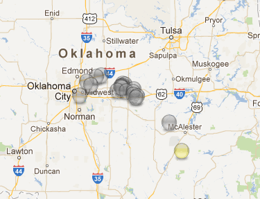
Oklahoma (not many)
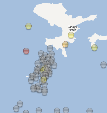
Andreanof Islands, Alaska ( quite a few)
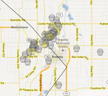
Brawley (there were a lot more green icons but still quite a few mag3+'s too)
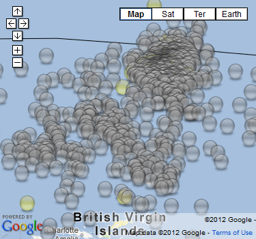
Virgin Islands ( Holy Cow)
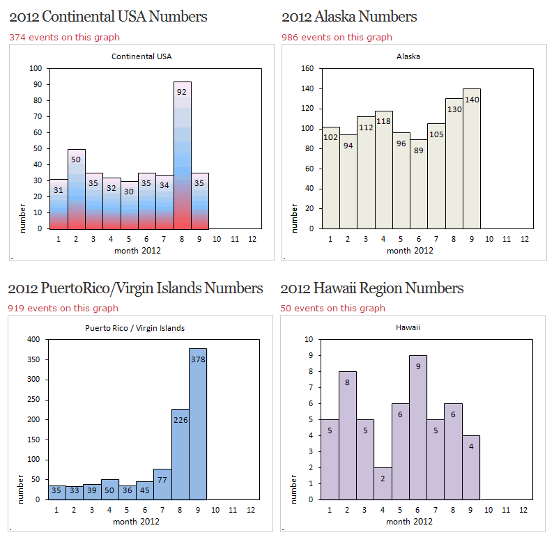
and the graphs (this is a thumbnail, click on it if you dare ........ not a lot of quakes really)
I'll do an update after the end of Oct. and add another set and the graphs will change.
Might have to do a separate page for each year, its a lot of html code to feed on and keep it in order, I lost my place a few times.
Aw what the heck its a Labour Day Holiday Weekend, its blowing a Gale so what to do?
Hmmm I know lets show USGS a thing or two
US and Territories old style map layout (mag 3+ only) using thie own data.
2585 events
5170 icons (one set of maps with them all on it, and 9 sets of the regions)
40 maps
4 graphs
It will take a little time to load
a few screenshots of points of interest
Oklahoma (not many)
Andreanof Islands, Alaska ( quite a few)
Brawley (there were a lot more green icons but still quite a few mag3+'s too)
Virgin Islands ( Holy Cow)
and the graphs (this is a thumbnail, click on it if you dare ........ not a lot of quakes really)
I'll do an update after the end of Oct. and add another set and the graphs will change.
Might have to do a separate page for each year, its a lot of html code to feed on and keep it in order, I lost my place a few times.
edit on 21-10-2012 by muzzy because: (no reason given)
new topics
-
4/27/24 New Jersey Earthquake
Fragile Earth: 2 hours ago -
Fun with extreme paints
Interesting Websites: 3 hours ago -
CIA is alleged to be operat social media troll frms in Kyiv
ATS Skunk Works: 5 hours ago -
Rainbow : Stargazer
Music: 5 hours ago -
I sleep no more.
Philosophy and Metaphysics: 8 hours ago -
Canada caught red-handed manipulating live weather data and make it warmer
Fragile Earth: 8 hours ago -
Why Files Our Alien Overlords | How We Secretly Serve The Tall Whites
Aliens and UFOs: 9 hours ago -
Curse of King Tuts Tomb Solved
Ancient & Lost Civilizations: 10 hours ago -
What allies does Trump have in the world?
ATS Skunk Works: 10 hours ago
top topics
-
Canada caught red-handed manipulating live weather data and make it warmer
Fragile Earth: 8 hours ago, 16 flags -
Why Files Our Alien Overlords | How We Secretly Serve The Tall Whites
Aliens and UFOs: 9 hours ago, 10 flags -
Curse of King Tuts Tomb Solved
Ancient & Lost Civilizations: 10 hours ago, 8 flags -
What allies does Trump have in the world?
ATS Skunk Works: 10 hours ago, 4 flags -
I sleep no more.
Philosophy and Metaphysics: 8 hours ago, 4 flags -
CIA is alleged to be operat social media troll frms in Kyiv
ATS Skunk Works: 5 hours ago, 4 flags -
4/27/24 New Jersey Earthquake
Fragile Earth: 2 hours ago, 4 flags -
Rainbow : Stargazer
Music: 5 hours ago, 1 flags -
Fun with extreme paints
Interesting Websites: 3 hours ago, 1 flags
active topics
-
CIA is alleged to be operat social media troll frms in Kyiv
ATS Skunk Works • 20 • : malte86 -
Democrats have Reduced using the term Bidenomics and Republicans have Increased
2024 Elections • 10 • : hovejo4021 -
Fun with extreme paints
Interesting Websites • 3 • : Hakaiju -
What is the white pill?
Philosophy and Metaphysics • 24 • : lilzazz -
Do you ever just get "bored" of everything?
Rant • 25 • : FlyersFan -
University of Texas Instantly Shuts Down Anti Israel Protests
Education and Media • 352 • : FlyersFan -
Remember These Attacks When President Trump 2.0 Retribution-Justice Commences.
2024 Elections • 62 • : Irishhaf -
-@TH3WH17ERABB17- -Q- ---TIME TO SHOW THE WORLD--- -Part- --44--
Dissecting Disinformation • 712 • : cherokeetroy -
Shocking Number of Voters are Open to Committing Election Fraud
US Political Madness • 14 • : StudioNada -
I sleep no more.
Philosophy and Metaphysics • 11 • : lilzazz