It looks like you're using an Ad Blocker.
Please white-list or disable AboveTopSecret.com in your ad-blocking tool.
Thank you.
Some features of ATS will be disabled while you continue to use an ad-blocker.

Quake Watch 2012
page: 227share:
Originally posted by angelchemuel
reply to post by Hellas
Morning Hellas....you OK?
Rainbows
Jane
Yes, thanks for asking. I didn't feel the ones near Crete this time. It is kinda strange thought.. 4 different spots were "hit" in just 24 hours in Greece.
reply to post by Hellas
Guess we'll have to wait for "Da Boyz" to get on here and tell us whether there is any link to Santorini/fault lines etc...from what I can see that fault line was quite active going all the way up through Turkey and Iran.
Stating the obvious....stay safe!
Rainbows
Jane
Guess we'll have to wait for "Da Boyz" to get on here and tell us whether there is any link to Santorini/fault lines etc...from what I can see that fault line was quite active going all the way up through Turkey and Iran.
Stating the obvious....stay safe!
Rainbows
Jane
Originally posted by angelchemuel
reply to post by Hellas
Guess we'll have to wait for "Da Boyz" to get on here and tell us whether there is any link to Santorini/fault lines etc...from what I can see that fault line was quite active going all the way up through Turkey and Iran.
Stating the obvious....stay safe!
Rainbows
Jane
The ones in Crete could be.. the other ones not so much.
This is an oddly placed earthquake.
Mag 3.4 located 50km NNE of Chapleau, Canada (USGS event page)
Google Map location
Mag 3.4 located 50km NNE of Chapleau, Canada (USGS event page)
Google Map location
Crete and Greece 21/09/2012 00:10:01 to 22/09/201 15:38:37UTC, data from National Observatory of Athens
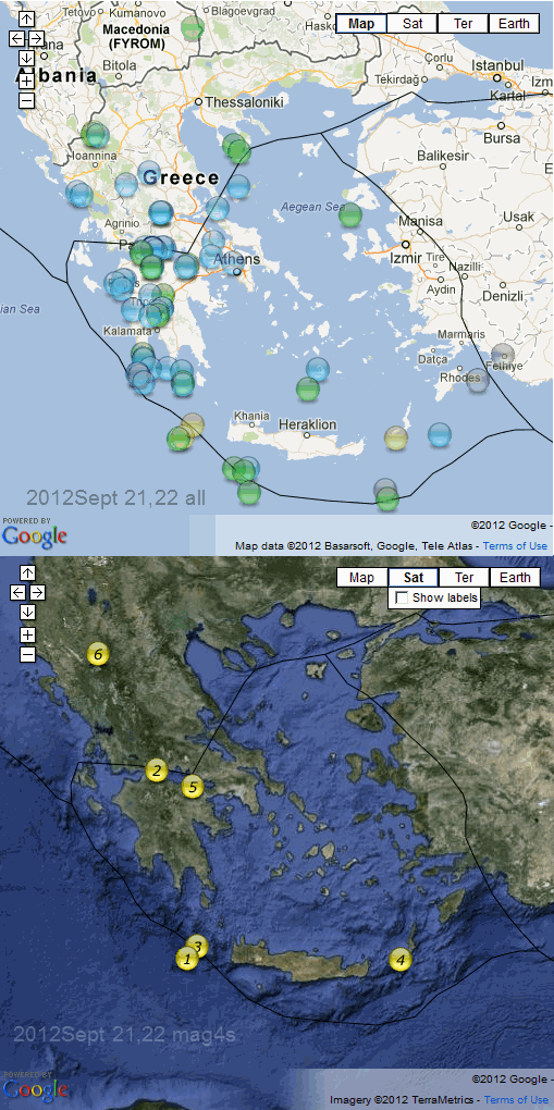
interactive Aegean map all quakes
interactive Aegean map mag 4+ only numbered in sequence
Seq#, When, Lat, Long, Mag ML, Depth, Location
6, 2012-09-22 06:15:57, 40.1592, 20.8288, 4.5, 17.3, 14 Km NNE from Konitsa
5, 2012-09-22 03:52:24, 38.086, 22.7377, 4.9, 25.1, 23 Km NW from Corinth
4, 2012-09-22 03:51:10, 35.2783, 26.944, 4.0, 26.2, 7 Km SSE from Kasos
3, 2012-09-21 15:39:17, 35.4932, 22.825, 4.4, 61.1, 57 Km SW from Andikithira
2, 2012-09-21 15:21:21, 38.3493, 22.0158, 4.0, 14.1, 13 Km NNW from Aiyion
1, 2012-09-21 08:47:40, 35.3033, 22.6335, 4.8, 16.4, 84 Km SW from Andikithira
numbers 1, 3 and 4 on the subduction zone
2 and 5 on the Continental Rift Boundry
6 ??
Data Processed by QVSData Pro
edit on 22-9-2012 by muzzy because: (no reason given)
I am assuming the black lines are fault lines? If they are can I assume what I posted to Hellas earlier today is correct then....we've been waiting
for one of 'Da Boyz' to come in!
Rainbows
Jane
Rainbows
Jane
reply to post by angelchemuel
yep, if you use the interactive map and click on a line somewhere it should popup a tag with the fault type.
Its just the one UGS use on their KML, I took the colours out because it was too confusing beside the coloured icons and roads on the maps.
No obvious trend to the sequence though, goes from the subduction zone at 1. up to the Gulf of Corinth west of Crete at 2., back to the SZ at 3., over to Karpathos east of Crete at 4., back to the Gulf of Corinth at 5. and ends in the Ioannina mountains in the north west at 6.
Looks like the whole Aegean (Hellenic) Plate went south a bit more than the 0.1mm per day allowed (37mm/year divided by 365 days)
usgs Greece summary
or maybe 0.1mm movement is enough to trigger a Mag 4
edit on 22-9-2012 by muzzy because: (no reason given)
reply to post by Olivine
Not quite as rare as hen's teeth but getting on that way. I only have the 13 months of Canadian data so far but that does show a mag 2.0 ML in the region back in Feb of this year.
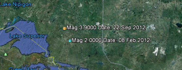
I was also quite interested to note that Canada extends it's watch right out to the MAR which is something I did not realise.
There have been 3 recorded in the Atlantic in the past 7 days. Note the difference in magnitude for the Canadian version. 5.6 ML to USGS 4.8 mb. Very approximately that is 0.4 Mw difference and 0.4 is 4 times stronger.

The Canadian 3.9 is MN - not sure what that is yet as a scale - and the USGS is 3.9 mbLg.
Not quite as rare as hen's teeth but getting on that way. I only have the 13 months of Canadian data so far but that does show a mag 2.0 ML in the region back in Feb of this year.
I was also quite interested to note that Canada extends it's watch right out to the MAR which is something I did not realise.
There have been 3 recorded in the Atlantic in the past 7 days. Note the difference in magnitude for the Canadian version. 5.6 ML to USGS 4.8 mb. Very approximately that is 0.4 Mw difference and 0.4 is 4 times stronger.
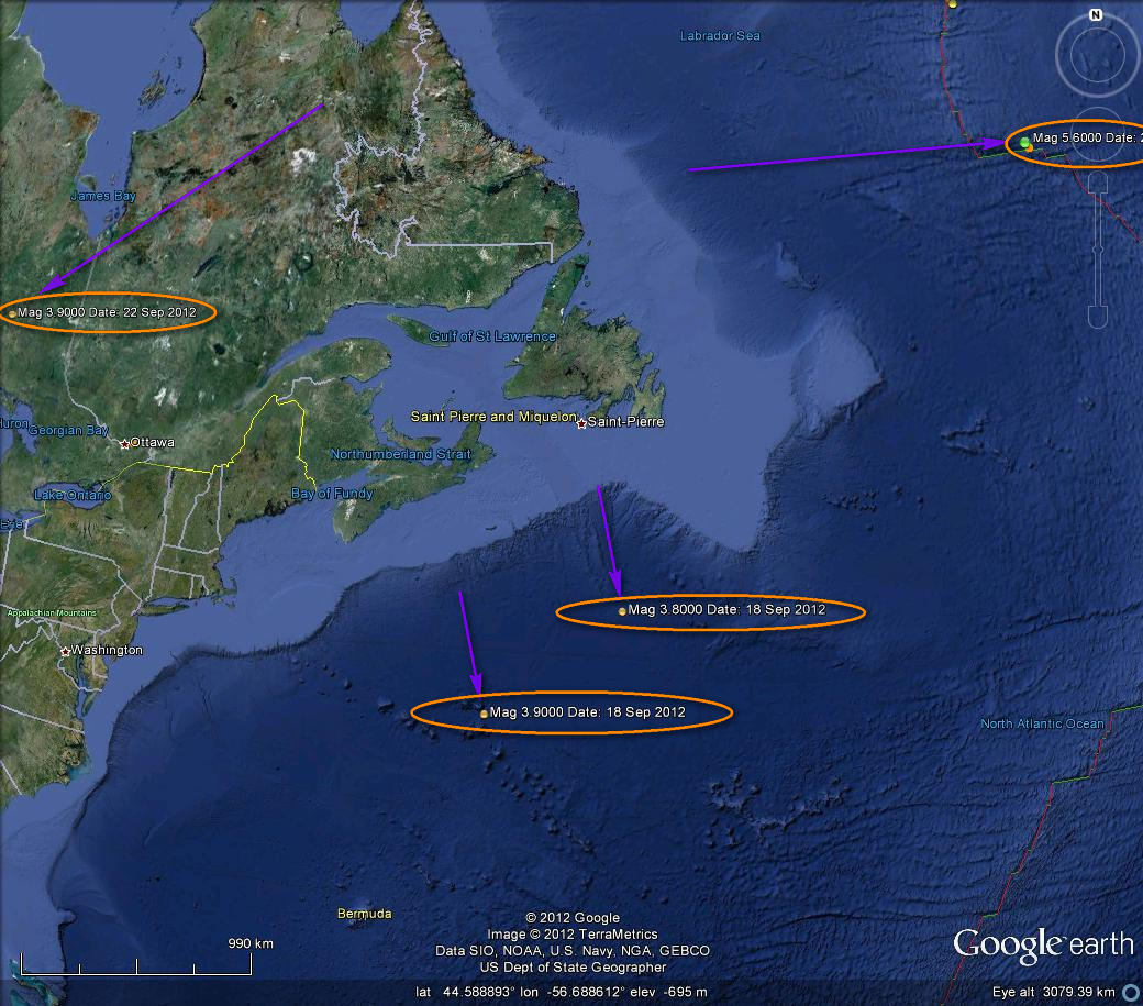
The Canadian 3.9 is MN - not sure what that is yet as a scale - and the USGS is 3.9 mbLg.
reply to post by muzzy
quote]Looks like the whole Aegean (Hellenic) Plate went south a bit more than the 0.1mm per day allowed (37mm/year divided by 365 days)
usgs Greece summary
or maybe 0.1mm movement is enough to trigger a Mag 4
Or maybe 60 days of tension (6mm) is enough, or 120 days (12mm) etc etc. I don't think the stress for a quake builds in one day.
Lots of interesting movements there. GE shows a resultant of 9mm NNE which I find very curious. The Aegean plate is moving SW at variously between 30 and 37 mm depending on the source you look at and the African plate is moving NNE at 40mm and subducting, and the Anatolian plate and Arabic plates are pushing round.
But the statement on the map you referenced say "vitesse par rapport a L'Afrique" which is "speed compared to Africa" so is this saying Africa is being considered as static on that map? If subduction is taking place then the down moving plate has no effect on the plate above other than to slow it down a bit. All of this depends entirely upon the datum point for the GPS and without that you have no idea. Is the Aegean plate is moving at 37mm/yr relative to Africa as the datum, or is the datum the other side of the Gulf Of Corinth?
Of course according to some 'scientists' Europe is starting to slide under Africa, despite any evidence to support this and plenty to support the other. They even suggested that this would lead to more Med tsunamis and OMG we need an early warning system!
Plate tectonics is not a simple subject. It is nothing like as simple as the maps would suggest and I don't think we know even a small percentage of what actually happens (the geologists will of course tell you otherwise - they have to it is their jobs on the line). It is not even a subject upon which there is complete agreement and several different theories exist, all with their problems.
Would 7,000,000 cubic kilometres (very very approximately) moving a few millimetres set up stresses over a shortish period of time? I guess it would. Is that 21,000,000,000,000,000 tonnes @ a density of 3 tonnes/cu mtr or have I got some zeros in the wrong place? I think in the American method that is 21 quadrillion tons floating about the Aegean. Don't get your finger wedged in the gap!
reply to post by PuterMan
A seismologist here said that a "big one" is long due.
Today's activity so far, local time now (1:05pm)

source EMSC
A seismologist here said that a "big one" is long due.
Today's activity so far, local time now (1:05pm)
source EMSC
edit on 23-9-2012 by Hellas because: (no reason given)
Originally posted by PuterMan
reply to post by muzzy
[snippy snip]
Would 7,000,000 cubic kilometres (very very approximately) moving a few millimetres set up stresses over a shortish period of time? I guess it would. Is that 21,000,000,000,000,000 tonnes @ a density of 3 tonnes/cu mtr or have I got some zeros in the wrong place? I think in the American method that is 21 quadrillion tons floating about the Aegean. Don't get your finger wedged in the gap!
The following is my opinion as a member participating in this discussion.
I'd say your calculations are bang on. It's 7,000,000 x 1,000 x 1,000 x 1,000 cubic metres x 3 tonnes/ cu.metre to determine the mass, and unless we've both messed up, that gives 21 with 15 zeroes for the "tonnage".
But while that would set up stresses, the problem is working out what the pressure per unit area is. We'd need to know the details of the "contact" area and also the theoretical friction coefficients and (in the event of a quake) the load failure rate -- and I don't think anyone has worked all those out for this case yet.
So meanwhile, yeah -- mind the gap!
Mike
As an ATS Staff Member, I will not moderate in threads such as this where I have participated as a member.
Originally posted by PuterMan
reply to post by Olivine
I was also quite interested to note that Canada extends it's watch right out to the MAR which is something I did not realise.
There have been 3 recorded in the Atlantic in the past 7 days. Note the difference in magnitude for the Canadian version. 5.6 ML to USGS 4.8 mb. Very approximately that is 0.4 Mw difference and 0.4 is 4 times stronger.
I did not know their coverage was that extensive either. Thank you so much for the heads up.
Concerning USGS, I get the feeling they don't put much value in locating and listing moderate sized earthquakes from the mid-oceanic ridges in the Atlantic or Pacific.
Personally, I feel the more complete (and reasonably accurate) the data, the better our understanding of the timing and nature of the processes at work will be.
September 26 2012, the day of atonement, is the next 188 day earthquake cycle. It's also the closest approach of nibiru to earth according to John
Moore. I'm thinking it will be a Canary Islands event.
Originally posted by earthmoney123
September 26 2012, the day of atonement, is the next 188 day earthquake cycle. It's also the closest approach of nibiru to earth according to John Moore. I'm thinking it will be a Canary Islands event.
There is no such thing as 188-day earthquake cycle. There is no proof of strong earthquakes happen between every 188 days. Its just viral marketing campaign selling the dvd. Its pretty genius idea, on average, major earthquake happen every 18 days, and time window for this 188 days cycle could be +/- 1 day, so changes are pretty good that strong earthquake falls on these 3 days. This guy is probably very rich after people buying his nonsense dvd.
edit on 23-9-2012 by Thebel because: (no reason given)
reply to post by earthmoney123
Hello earthmoney123 and welcome to ATS and in particular to Quake Watch.
Here you will find some of the best information about earthquakes on the Internet. Why do I say that? Because the members who frequent this thread, and those who lurk and occasionally stick their heads up into the firing line on the whole produce excellent work that is based on facts.
You will find some of the alternative geophysical theories on this thread: Geophysics which is hosted by Zenius who you will also see on this thread.
Anything of a speculative nature to do with Yellowstone / Fracking / Arkansas / Bird Deaths / Hudson Bay / Life / Death / Resurrection / the Economy / Politics / Religion etc you can post on the thread hosted by Robin Marks/Eric Blair: Robinesque Ruminations
Volcano stuff you will find on Volcano Watch and last but by no means least the giant Yellowstone thread is a BIG read all about the Park that has passed page 700.
These and more ATS links, and links to many external sites you can find in my signature block and in the signatures of others.
Never be afraid to ask a question. We will always try to answer, and no one gets ridiculed here because of a lack of knowledge on what is a complex and multifaceted subject. (Well not if the question is reasonable at least!)
It is somehow strange, because I never had such a feeling, but somehow I have the feeling there will be another bigger or even big one in Japan within
this year.....
I cant tell you why, it is just a feeling. Maybe it is just because I miss my Japanese girlfriend a lot at the moment and will not see her the rest of the year...
I cant tell you why, it is just a feeling. Maybe it is just because I miss my Japanese girlfriend a lot at the moment and will not see her the rest of the year...
M Location
Click event below for details Time
UTC Lat Lon D
km
3.3 87km N of Road Town, British Virgin Islands 2012-09-23 22:39:09 19.192°N 64.771°W 6.0
3.4 86km N of Road Town, British Virgin Islands 2012-09-23 21:54:58 19.186°N 64.743°W 23.0
3.4 73km N of Road Town, British Virgin Islands 2012-09-23 21:18:05 19.078°N 64.676°W 65.0
3.0 76km N of Road Town, British Virgin Islands 2012-09-23 21:07:46 19.110°N 64.633°W 82.0
3.7 95km N of Road Town, British Virgin Islands 2012-09-23 19:44:45 19.277°N 64.534°W 60.0
3.5 70km N of Road Town, British Virgin Islands 2012-09-23 19:38:45 19.057°N 64.636°W 65.0
3.5 83km N of Road Town, British Virgin Islands 2012-09-23 19:18:17 19.158°N 64.754°W 45.0
3.2 65km N of Road Town, British Virgin Islands 2012-09-23 18:43:55 19.007°N 64.632°W 68.0
3.3 78km N of Road Town, British Virgin Islands 2012-09-23 18:33:25 19.124°N 64.600°W 76.0
2.9 80km N of Road Town, British Virgin Islands 2012-09-23 16:13:13 19.145°N 64.685°W 52.0
3.1 76km N of Road Town, British Virgin Islands 2012-09-23 15:45:08 19.102°N 64.695°W 70.0
2.9 81km N of Road Town, British Virgin Islands 2012-09-23 13:04:09 19.148°N 64.681°W 60.0
3.0 49km NE of Road Town, British Virgin Islands 2012-09-23 12:46:53 18.764°N 64.326°W 39.0
2.9 138km NNE of Road Town, British Virgin Islands 2012-09-23 11:14:20 19.643°N 64.350°W 30.0
3.1 147km NNE of Road Town, British Virgin Islands 2012-09-23 10:23:32 19.677°N 64.157°W 38.0
3.2 113km N of Road Town, British Virgin Islands 2012-09-23 10:21:02 19.439°N 64.515°W 56.0
3.6 45km NE of Miches, Dominican Republic 2012-09-23 09:07:17 19.291°N 68.766°W 82.0
2.8 117km NE of Road Town, British Virgin Islands 2012-09-23 08:44:47 19.279°N 63.967°W 98.0
3.3 137km NNE of Road Town, British Virgin Islands 2012-09-23 08:42:31 19.555°N 64.088°W 72.0
3.1 97km NNW of San Antonio, Puerto Rico 2012-09-23 08:31:58 19.251°N 67.567°W 33.0
2.8 113km N of Road Town, British Virgin Islands 2012-09-23 05:59:50 19.438°N 64.569°W 20.0
4.4 66km N of Road Town, British Virgin Islands 2012-09-23 05:34:43 19.461°N 64.601°W 14.0
3.1 106km N of Culebra, Puerto Rico 2012-09-23 01:11:24 19.264°N 65.254°W 7.0
2.9 152km NNE of Road Town, British Virgin Islands 2012-09-22 20:58:37 19.698°N 64.076°W 45.0
3.3 101km N of Vieques, Puerto Rico 2012-09-22 15:26:16 19.330°N 65.672°W 97.0
2.6 137km N of Road Town, British Virgin Islands 2012-09-22 14:37:48 19.639°N 64.376°W 31.0
2.9 73km N of Culebra, Puerto Rico 2012-09-22 09:30:47 18.968°N 65.340°W 40.0
3.3 127km NNE of Road Town, British Virgin Islands 2012-09-22 08:29:57 19.508°N 64.228°W 72.0
3.3 135km NNE of Road Town, British Virgin Islands 2012-09-22 07:03:51 19.613°N 64.352°W 69.0
3.2 140km NNE of Road Town, British Virgin Islands 2012-09-22 06:44:35 19.635°N 64.255°W 69.0
3.4 111km NNE of Road Town, British Virgin Islands 2012-09-22 06:09:42 19.344°N 64.211°W 87.0
3.9 130km N of Road Town, British Virgin Islands 2012-09-22 05:31:59 19.553°N 64.464°W 5.8
3.1 75km NNE of Road Town, British Virgin Islands 2012-09-22 02:18:33 19.023°N 64.288°W 58.0
2.8 69km NNE of Road Town, British Virgin Islands 2012-09-22 01:21:21 18.956°N 64.281°W 61.0
earthquake.usgs.gov...
What the heck is going on in the Carib?
I am new to this quake watching, self learning...so let me know if I shouldn't be interested in this.
edit on 23-9-2012 by timetothink because:
(no reason given)
that particular spot has been having swarms for quite some time if you scroll back a few pages i believe puterman talked about that particular area
the largest eq so far in that swarm area was back on 9/4 at 5.2 but worth keeping an eye on.
new topics
-
James O keefe from Veritas controlled opposition.
Medical Issues & Conspiracies: 1 hours ago -
Political Commentator Alice Stewart Supposedly Died of Natural Causes on a Sidewalk Last Night.
General Conspiracies: 1 hours ago -
BIG REVEAL | Intelligence advisor says ‘catastrophic disclosure’ about UFOs may be on horizon
Aliens and UFOs: 1 hours ago -
Madness will ensue here. Be ready.
General Chit Chat: 2 hours ago -
FO!!! FO!! FO!!...dammit!!
Food and Cooking: 3 hours ago -
The Rift
Fantasy & Science Fiction: 5 hours ago -
Would you give part of your liver to someone who needed it but could not stop drinking?
General Chit Chat: 5 hours ago -
Scientists assaulted at Skinwalker Ranch (Bigelow era)
Aliens and UFOs: 10 hours ago
top topics
-
Cool video of bees protecting other bugs
General Chit Chat: 12 hours ago, 11 flags -
Mods Are Sleeping: Let's Post Protists!
General Chit Chat: 13 hours ago, 8 flags -
1st Jewish Biden Appointee to Resign Over Gaza Quits on Nakba Day
Political Issues: 17 hours ago, 6 flags -
Madness will ensue here. Be ready.
General Chit Chat: 2 hours ago, 5 flags -
The horse
Jokes, Puns, & Pranks: 12 hours ago, 4 flags -
Scientists assaulted at Skinwalker Ranch (Bigelow era)
Aliens and UFOs: 10 hours ago, 4 flags -
Political Commentator Alice Stewart Supposedly Died of Natural Causes on a Sidewalk Last Night.
General Conspiracies: 1 hours ago, 3 flags -
BIG REVEAL | Intelligence advisor says ‘catastrophic disclosure’ about UFOs may be on horizon
Aliens and UFOs: 1 hours ago, 3 flags -
FO!!! FO!! FO!!...dammit!!
Food and Cooking: 3 hours ago, 3 flags -
The Rift
Fantasy & Science Fiction: 5 hours ago, 2 flags
active topics
-
Biden accepts Trumps debate challenge
2024 Elections • 195 • : WeMustCare -
Want Some Secret Knowledge?
Paranormal Studies • 45 • : Compendium -
BIG REVEAL | Intelligence advisor says ‘catastrophic disclosure’ about UFOs may be on horizon
Aliens and UFOs • 11 • : Caver78 -
Elizando: I was notified yesterday… threat against myself and several other whistleblowers
Whistle Blowers and Leaked Documents • 23 • : doubledan717 -
1st Jewish Biden Appointee to Resign Over Gaza Quits on Nakba Day
Political Issues • 72 • : cherokeetroy -
Political Commentator Alice Stewart Supposedly Died of Natural Causes on a Sidewalk Last Night.
General Conspiracies • 7 • : CriticalStinker -
The biggest problem with the Hush money trial
US Political Madness • 491 • : RazorV66 -
Remember These Attacks When President Trump 2.0 Retribution-Justice Commences.
2024 Elections • 71 • : Connector -
Mood Music Part VI
Music • 3229 • : Hellmutt -
San Francisco Program To Give Free Booze to the Homeless
Social Issues and Civil Unrest • 45 • : Zanti Misfit