It looks like you're using an Ad Blocker.
Please white-list or disable AboveTopSecret.com in your ad-blocking tool.
Thank you.
Some features of ATS will be disabled while you continue to use an ad-blocker.

Strange Underwater Anomalies: Florida, Cuba, Japan!
page: 4share:
Originally posted by starless and bible black
Originally posted by Samuelis
reply to post by manticorex5
Because it would then be proof that global warming isn't man made. ???
Of course it isn't. People have been trained to have feelings of low self-esteem. The MSM even has the nerve to continue to tell us to turn off the lights on 'earth day', while radiation circles the planet and 60,000 bomb's worth of heat spew in to the atmosphere, uncontrolled, none of it carbon based. They are so full of zhit, but the government has already spent the money they are counting on through taxing carbon, so, you know how it goes.
earthday is just to let you know who's really in power. it's also sort of a practical joke in illuminati circles.
they laugh it up on earth day during dinner, in the comfort of their mansions, eating 7 course meals while their $350,000 diamond and crystal studded chandelier burns a small fortune lighting up the dinning room.
mean while you're all huddled together eating tuna out of can in almost complete darkness, (can't use the electric stove) burning one candle to light your entire house (apparently this saves the earth), and on top of that freezing, because in some parts of the world earth day lands while temps are still low.
it's the biggest sucker bullsh-t day the nwo has ever thrown at the world.
it mocks the parts of the world where entire villages live in such poverty that one street lamp is the only thing that lights the entire town at night. after the sun sets, it's eerie and pitch black.
i've been those villages, and it's sad. everyday is earth day for those people.
Good post OP,this planet is one constantly changing variable and we as technological observant aware creations have only made in the last 120 years
advancement towards understanding what we have obsered in our era.However observations are just that and are limited by observation and timeline, and
it should be remembered the planets been around for a long time with many species observing its global changes and going into extinction not knowing
how,why ! We will be the first creation to know how and why as it is occurring.
Graham hancock is well respected in my view,I have read a good many of his books of interpretation and his reasearch and diligence is well represented and critically studied even by the author himself.
Although his book Fingerprints of the gods,was and still is a interesting perspective of more civilized people in ancient times than current history records is a fascinating observation,never mind the wealth of up close photos,diagrams,and geological study work in his research is staggering,for me he is geniune in his search,albeit with alluding,note I say alluding to atlantis,alien or the extreme extraterrestial intervention it does not reflect his awesome input in this field of research of past undewater civilizations.He is with out any doubt a better read than von danniken,who makes assertions beyond observation and who does allude..
Peace gringo
edit on 22-3-2011 by gringoboy because: (no reason given)
I don't have anything to add but had to say this is an excellant thread.
Looking forward to seeing if there are more additions to findings under our ocean floor.
Looking forward to seeing if there are more additions to findings under our ocean floor.
Seriously, get away from looking at satellite or celestial photographs to 'discover' something 'new'. To me everything shown looks mundanely
normal. It's water flow that creates channels, and deep down it's our ocean tectonic plates releasing deep lava as the ocean spreads and the
continents clash. Its been going on for billions of years, those AREN'T 'roads'. Scale would outline that alone.
People see pictures of what they don't understand and see things down the street they know 'that looks similar'. Dude, it's not the same. Look at your scale of distance in those images and ask yourself, do you know of a road a half a mile wide?
Those underwater 'steps' photos are quite frankly, a disingenuous attempt to make some point because they aren't where those ocean photos are from!!!
Shame on you.
reply to post by Illustronic
Read some graham hancock books man,seriously theres some fantastic critical finds in them.
Nice one OP
Read some graham hancock books man,seriously theres some fantastic critical finds in them.
Nice one OP
reply to post by Illustronic
Where do they come from?
Oh, you can't have an egg if the chicken isn't there to lay it
Where do they come from?
Oh, you can't have an egg if the chicken isn't there to lay it
edit on 22-3-2011 by mesle123 because: (no reason given)
reply to post by Qumulys
I believe there are submerged "colonies" from the past in areas on earth. However, I also think that some of these pics show damage from Fishing Trawl Lines that scrape the bottom of the ocean. For evidence of this or further research to confirm or deny this, I recommend you watch the television series called "Treasure Quest". This show highlights the damage a trawl line can do to older shipwrecks, essentially acting like a wrecking ball to obliterate the ships. This hinders the research and analyzing of history.
I believe there are submerged "colonies" from the past in areas on earth. However, I also think that some of these pics show damage from Fishing Trawl Lines that scrape the bottom of the ocean. For evidence of this or further research to confirm or deny this, I recommend you watch the television series called "Treasure Quest". This show highlights the damage a trawl line can do to older shipwrecks, essentially acting like a wrecking ball to obliterate the ships. This hinders the research and analyzing of history.
Unfortunately a potentially great thread is marred by bathymetrics again...
We went through this in february of 2009
Anyway... The underwater stuff near japan was nice
We went through this in february of 2009
Anyway... The underwater stuff near japan was nice
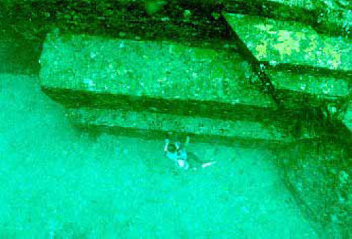
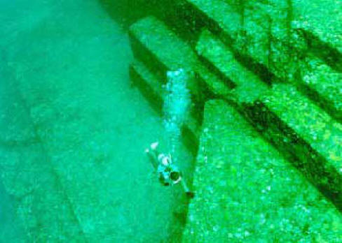
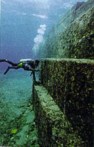
Here's more....
Off the Japanese coast...
Courtesy: Rabithole
And here's something that'll blow you away. What looks like a sphinx under the sea off Alexandria...
rabbithole2.com...
Off the Japanese coast...
Courtesy: Rabithole
And here's something that'll blow you away. What looks like a sphinx under the sea off Alexandria...

Off the shores of Alexandria, the city of Alexander the Great, lies what is believed to be the ruins of the royal quarters of Cleopatra. A team of marine archaeologists led by Frenchman Franck Goddio made excavation on this ancient city from where Cleopatra, the last queen of the Ptolemies, ruled Egypt. Historians believe this site was submerged by earthquakes and tidal waves more than 1,600 years ago.
rabbithole2.com...
reply to post by daggyz
trying to understand where exactly your post came from?
It is a hypothetical post, and a good one at that!
i believe some of the pics are natural, and I believe some are unnatural.
however the fact remains, humanity went through an ice age, and there is plenty of evidence to suggest humans had "society" before this happened. EVERYONE knows, even wolfs know, that human build near water first! Which means that when water levels rise due to climate change, those places near the water will be flooded?
they;ve found underwater establishments in egypt and britain, and that is confirmed. Are we supposed to believe they were isolated incidents? Are we supposed to believe that no other coastal areas were colonized?
reply to post by mesle123
Near the Bahamas and off others off the coast of Japan, there are also some in Indonesia. They are not rare, one would think a natural phenomena is at work creating them.
Near the Bahamas and off others off the coast of Japan, there are also some in Indonesia. They are not rare, one would think a natural phenomena is at work creating them.
So OK, the OP caught up with me, so it was not part of his OP delivery, disingenuous.
I checked the area around the Florida picture posted on Google maps and I find those strange straight and curved lines everywhere at that place. Can
someone try to provide an insight of what they are?
Google Maps Florida Lines
Here is a higher resolution image of the original Florida satellite image:
Florida High-Res
Google Maps Florida Lines
Here is a higher resolution image of the original Florida satellite image:
Florida High-Res
reply to post by OrionHunterX
Very interesting! I wish I knew for a fact how to recognize suspect satellite anomalies....I just don't know what to think about a lot of these images. I'd probably guess that the first one is some sort of glitch due to the way the image is put together or processed. I just can't imagine such a long and squiggly line being anything real...The rest look pretty legit though, and I find the concept of large cities being lost beneath the waves of the Ocean quite believable. Whether due to something like an Island that sank, Earthquakes/Continental Plate Shifts, or even just radical climate change.
Very interesting! I wish I knew for a fact how to recognize suspect satellite anomalies....I just don't know what to think about a lot of these images. I'd probably guess that the first one is some sort of glitch due to the way the image is put together or processed. I just can't imagine such a long and squiggly line being anything real...The rest look pretty legit though, and I find the concept of large cities being lost beneath the waves of the Ocean quite believable. Whether due to something like an Island that sank, Earthquakes/Continental Plate Shifts, or even just radical climate change.
Some of these "manmade" looking lines and boxes are artifacts of how maps are composed.
Some of the "depth maps" are made with ocean vessels, and the NEXT pass, might be at a low or high tide. So suddenly, there is a difference in depth that looks like a wall.
It's pretty simple to explain why these structures show up in Google Maps and worldwind - MOST of them are from the Government and it's much of the same data. Same gravity/depth maps -- same "artifacts."
The "tube structure" near Cuba looks interesting. There is definitely plenty of space in the ocean that hasn't been fully explored. One day, I'd like to see infrared and ultraviolet with gravity maps -- something is eventually going to stand out.
>> The original location of Troy, by the way, was found with some ultraviolet satellite imagery in Africa. The old trails and waterways showed up, buried beneath sand. Some historians recognized certain described features and tracked them back to Troy. I believe, back then, these were taken from maps commissioned by oil companies - this was before the mapping data and satellite images were so much in the public domain.
reply to post by OrionHunterX
Google Earth Image Color Enhanced
NASA World Wind image
ok where did i see these images before ! well something that looks similar ! hmm thinking thinking ......
I got it!! its not even from this Planet its the 4th rock from the Sun
INCA CITY ON MARS = DRAGON CITY AKA SHAPESHIFTER CITY
www.wiolawapress.com...
Image Title: Inca City on Mars
Release Date: September 25, 2006
Source: Mars Global Surveyor
www.marsartgallery.com...
INCA CITY" RIDGES
www.marsanomalyresearch.com...
Zorgon's Site ! Awesome info
COSMIC SECRETS
The Enigmas on Mars 24
Mars Global Surveyor
"INCA CITY"
MOC wide-angle image E09-00186
www.thelivingmoon.com...

Google Earth Image Color Enhanced

NASA World Wind image
ok where did i see these images before ! well something that looks similar ! hmm thinking thinking ......
I got it!! its not even from this Planet its the 4th rock from the Sun
INCA CITY ON MARS = DRAGON CITY AKA SHAPESHIFTER CITY
www.wiolawapress.com...
Image Title: Inca City on Mars
Release Date: September 25, 2006
Source: Mars Global Surveyor
www.marsartgallery.com...
INCA CITY" RIDGES
www.marsanomalyresearch.com...
Zorgon's Site ! Awesome info
COSMIC SECRETS
The Enigmas on Mars 24
Mars Global Surveyor
"INCA CITY"
MOC wide-angle image E09-00186
www.thelivingmoon.com...
WOW!
Thanks so much for sharing. Thats pretty amazing.
Wonder what else is in the ocean that we cant see.
I love this stuff because it is within reach, something people can actually go to and study.
Thanks so much for sharing. Thats pretty amazing.
Wonder what else is in the ocean that we cant see.
I love this stuff because it is within reach, something people can actually go to and study.
Someone should go out into the deep and investigate these ridges or lines, I'm sure someone has already taken some underwater photos of these.
If this can happen due to a Tsunami in Japan, bigger catastrophes could have resulted in vast areas being submerged.
ibnlive.in.com...
The powerful earthquake that unleashed a devastating tsunami on Friday appears to have moved the main island of Japan by eight feet (2.4 meters).
"At this point, we know that one GPS station moved (eight feet), and we have seen a map from GSI (Geospatial Information Authority) in Japan showing the pattern of shift over a large area is consistent with about that much shift of the land mass," said Kenneth Hudnut, a geophysicist with the US Geological Survey (USGS).

ibnlive.in.com...
edit on 23-3-2011 by OrionHunterX because: (no reason
given)
new topics
-
Ohio finds over 100 non-citizens on votrer roles
US Political Madness: 1 hours ago -
Interview with Vladimir Putin to the Chinese Xinhua Agency
Politicians & People: 1 hours ago -
Meeting of a Russian hunter with a bear
ATS Skunk Works: 2 hours ago -
W.H.O when this is signed it is over.
US Political Madness: 9 hours ago
top topics
-
W.H.O when this is signed it is over.
US Political Madness: 9 hours ago, 7 flags -
The Great Mosaic of God Unfolding Before Our Eyes
Religion, Faith, And Theology: 15 hours ago, 4 flags -
Ohio finds over 100 non-citizens on votrer roles
US Political Madness: 1 hours ago, 3 flags -
Meeting of a Russian hunter with a bear
ATS Skunk Works: 2 hours ago, 2 flags -
Interview with Vladimir Putin to the Chinese Xinhua Agency
Politicians & People: 1 hours ago, 2 flags
active topics
-
Breaking--Hamas Accepts New Cease Fire
Middle East Issues • 489 • : Xtrozero -
Girl 11, Barred From Starting a Faith Club but Classmates are Allowed Pride Group
Education and Media • 354 • : Annee -
Ohio finds over 100 non-citizens on votrer roles
US Political Madness • 7 • : watchitburn -
Fake Aurora's produced by HAARP
Science & Technology • 86 • : MrsPixie -
Does having a computer enhance your life?
General Chit Chat • 20 • : davidmalhan -
The biggest problem with the Hush money trial
US Political Madness • 213 • : Annee -
Meeting of a Russian hunter with a bear
ATS Skunk Works • 12 • : Oldcarpy2 -
A new Why Files How CRISPR and AI Destroy the World
Science & Technology • 36 • : kwaka -
Silent Weapons
General Conspiracies • 14 • : xWorldxGonexMadx -
Candidate TRUMP Now Has Crazy Judge JUAN MERCHAN After Him - The Stormy Daniels Hush-Money Case.
Political Conspiracies • 1692 • : Oldcarpy2