It looks like you're using an Ad Blocker.
Please white-list or disable AboveTopSecret.com in your ad-blocking tool.
Thank you.
Some features of ATS will be disabled while you continue to use an ad-blocker.

Disappearing Earthquake Canadian Coast Today
page: 1share:
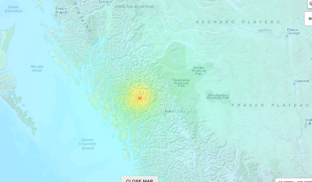
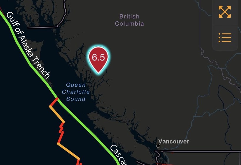
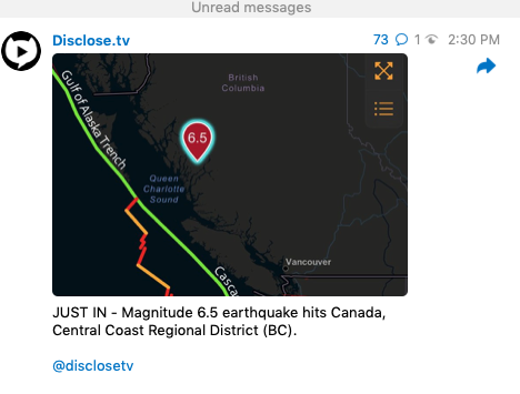
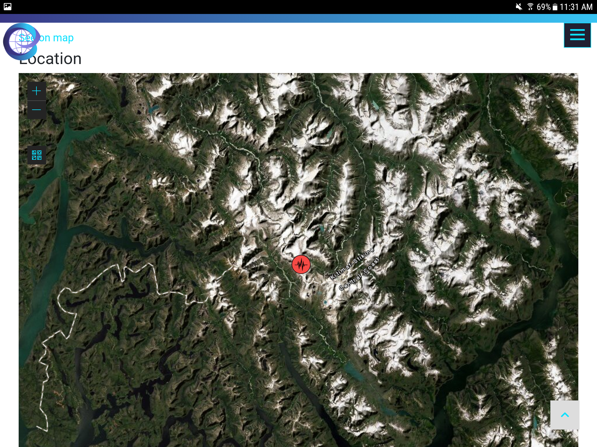
OK, so today I saw on Telegram a post that a 6.5 magnitude earthquake occurred along the coast of Canada. I went to the USGS site, and sure enough,
there was a big red spot indicating a big earthquake about half way up the Canadian west coast. Red spot indicates it occurred within the hour. I
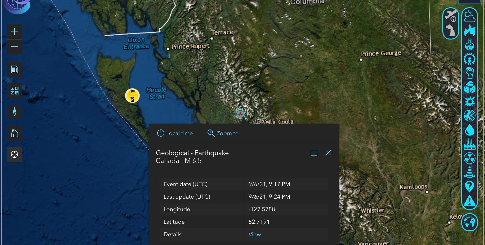
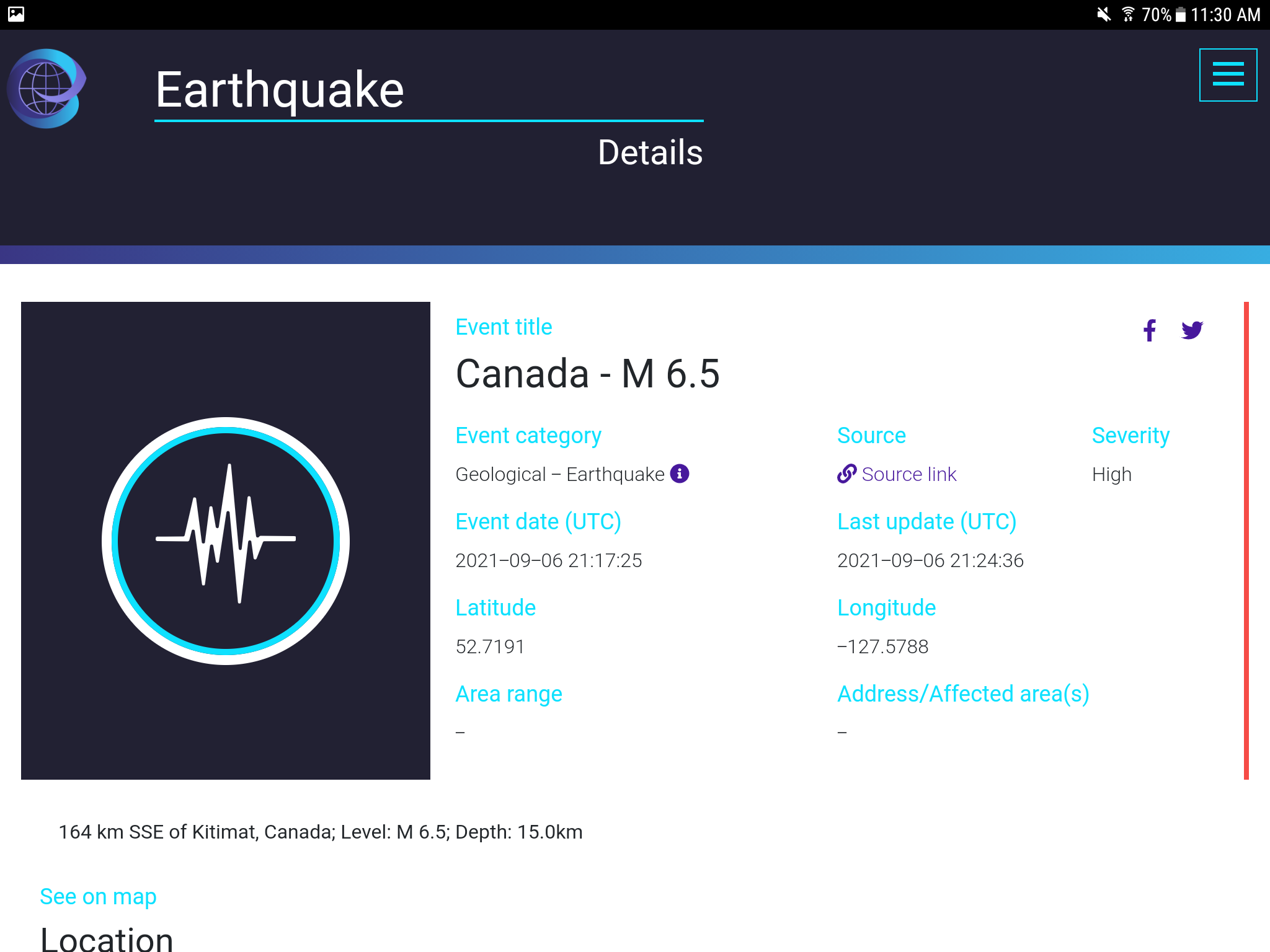
was curious about shake and tsunami, so I went to the shake map and took a screen shot for reference. When I went back to the main map, the big red
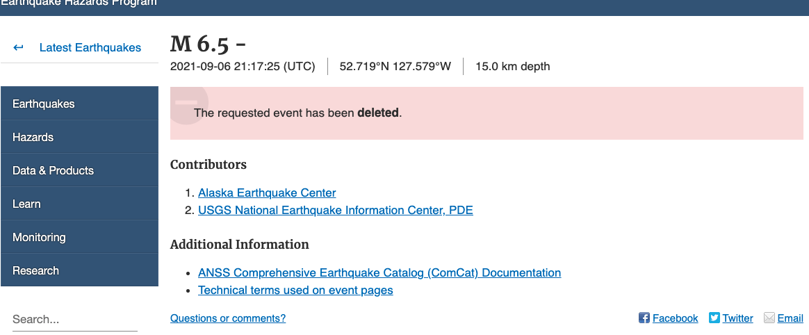
spot was GONE, it has never come back. When I went back into the shake map, it said event was deleted.
The only evidence I have is the couple of screen shots. The question is, why would USGS remove evidence of an earthquake? I did hear that the various earth watchers have said that evidence of earthquakes along the west coast and Canada were being scrubbed, but I would not have believed it if I hadn't seen it myself in real time.
Any theories?
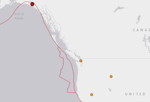
I have four images of the Telegram announcement of the earthquake, the shake map, the item announcing that the event deleted, and the regular USGS map with nothing in the area. I did not get a screen shot of the big red dot when it was there.
I am using Chrome, and I cannot figure out how to include these pictures in the post. All I get is a bar at the top that does not respond to the pictures.
The only evidence I have is the couple of screen shots. The question is, why would USGS remove evidence of an earthquake? I did hear that the various earth watchers have said that evidence of earthquakes along the west coast and Canada were being scrubbed, but I would not have believed it if I hadn't seen it myself in real time.
Any theories?
I have four images of the Telegram announcement of the earthquake, the shake map, the item announcing that the event deleted, and the regular USGS map with nothing in the area. I did not get a screen shot of the big red dot when it was there.
I am using Chrome, and I cannot figure out how to include these pictures in the post. All I get is a bar at the top that does not respond to the pictures.
edit on 7-9-2021 by Ceffer because: info
Earthquake live has removed as well a bit strange.
edit on 7-9-2021 by HawkEyi because: (no reason given)
a reply to: HawkEyi
www-theglobeandmail-com.cdn.ampproject.org... -65-earthquake-in/?amp_js_v=a6&_gsa=1&usqp=mq331AQKKAFQArABIIACAw%3D%3D#aoh=16310013425048&referrer=https%3A%2F%2Fwww.google.com&_tf=From%20%251 %24s&share=https%3A%2F%2Fwww.theglobeandmail.com%2Fcanada%2Farticle-computer-glitch-caused-false-reports-about-magnitude-65-earthquake-in%2F
www-theglobeandmail-com.cdn.ampproject.org... -65-earthquake-in/?amp_js_v=a6&_gsa=1&usqp=mq331AQKKAFQArABIIACAw%3D%3D#aoh=16310013425048&referrer=https%3A%2F%2Fwww.google.com&_tf=From%20%251 %24s&share=https%3A%2F%2Fwww.theglobeandmail.com%2Fcanada%2Farticle-computer-glitch-caused-false-reports-about-magnitude-65-earthquake-in%2F
originally posted by: gunshooter
a reply to: HawkEyi
www-theglobeandmail-com.cdn.ampproject.org... -65-earthquake-in/?amp_js_v=a6&_gsa=1&usqp=mq331AQKKAFQArABIIACAw%3D%3D#aoh=16310013425048&referrer=https%3A%2F%2Fwww.google.com&_tf=From%20%251 %24s&share=https%3A%2F%2Fwww.theglobeandmail.com%2Fcanada%2Farticle-computer-glitch-caused-false-reports-about-magnitude-65-earthquake-in%2F
Perhaps it wasn't an earthquake.
Perhaps it was just an explosion close to the seismometer? Perhaps someone bumped it off the bench?
Don't they use several seismometers in different locations to assess these?
a reply to: Ceffer
Wait till thecRing Of Fire goes off. Canada's west coast for instance.
Canada's west coast Volcanoes
Pacific Ring Of Fire
Wait till thecRing Of Fire goes off. Canada's west coast for instance.
Canada's west coast Volcanoes
Pacific Ring Of Fire
www.twitch.tv...
Dutchsinse has nothing and they would usually wet themselves with a 6.5 on the Canadian PNW. In fact, Dutchsinse has been eerily quiet since late August.
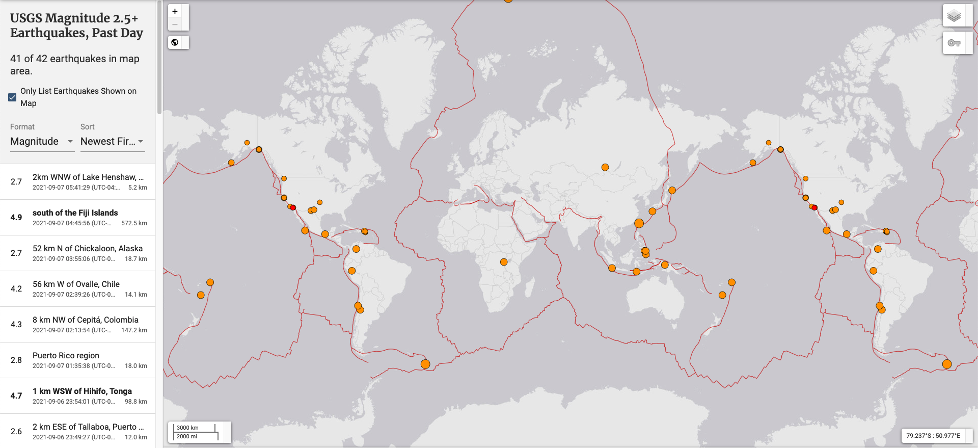
What's weird is the USGS list 41 of 42 earthquakes currently on the map even when you have expanded to have the whole map on there.
Dutchsinse has nothing and they would usually wet themselves with a 6.5 on the Canadian PNW. In fact, Dutchsinse has been eerily quiet since late August.
What's weird is the USGS list 41 of 42 earthquakes currently on the map even when you have expanded to have the whole map on there.
edit on 7-9-2021 by putnam6 because: (no reason given)
I came to realize during Desert Storm that the initial reports were the most truthful, even if inaccurate to some degree. The later reports were spin
or outright lies to cover-up the first reports. So given the information changed without explanation I tend to believe the first report before it's
deletion.
a reply to: Ceffer
False reports get deleted. It happens. Here an explanation and some examples. USGS is pretty transparent.
New Earthquake Hazards Program
Errata for Latest Earthquakes
False reports get deleted. It happens. Here an explanation and some examples. USGS is pretty transparent.
Occasionally our systems produce erroneous information that is released to the public via our web pages or Earthquake Notification System. These mistakes are generally promptly identified by seismologists, removed from our web pages, and “delete” e-mails are sent through ENS. In the interest of rapidly providing earthquake information to the public, most of the information about earthquakes that occur in the USA is automatically posted to the web and ENS if it meets quality standards.
New Earthquake Hazards Program
Errata for Latest Earthquakes
Better to cry wolf, than not cry at all.
Makes sense to auto report false positives, in the case of earthquakes.
It was probably just an auto-report and not a real quake.
What are the repercussions for automatically reporting a false quake?
What are the repercussions for accidentally ignoring a positive, because it might be false?
Consider those two questions, and it's obvious that it's not a conspiracy, but just SOP and best practice.
a reply to: Ceffer
As of 11:30AM EST.
Still showing on RSOE EDIS event map.
rsoe-edis.org...
Proof you are not going crazy or seeing things🤗 you're screenshots are spot on👍🏼
As of 11:30AM EST.
Still showing on RSOE EDIS event map.
rsoe-edis.org...
Proof you are not going crazy or seeing things🤗 you're screenshots are spot on👍🏼
edit on 7-9-2021 by Bigburgh because: (no reason given)
originally posted by: cmdrkeenkid
a reply to: Ceffer
False reports get deleted. It happens. Here an explanation and some examples. USGS is pretty transparent.
Occasionally our systems produce erroneous information that is released to the public via our web pages or Earthquake Notification System. These mistakes are generally promptly identified by seismologists, removed from our web pages, and “delete” e-mails are sent through ENS. In the interest of rapidly providing earthquake information to the public, most of the information about earthquakes that occur in the USA is automatically posted to the web and ENS if it meets quality standards.
New Earthquake Hazards Program
Errata for Latest Earthquakes
That's interesting, I've seen many considerably good size earthquakes in that area monthly.
Also have seen many false Volcano Eruption reports in that area via Flightradar24 that are eventually removed after 5 or so hours.
Thanks for that input.
Glitch,
Rebooting....😧
Rebooting....😧
edit on 7-9-2021 by Bigburgh because: (no reason given)
originally posted by: Ceffer
OK, so today I saw on Telegram a post that a 6.5 magnitude earthquake occurred along the coast of Canada. I went to the USGS site, and sure enough, there was a big red spot indicating a big earthquake about half way up the Canadian west coast. Red spot indicates it occurred within the hour. I was curious about shake and tsunami, so I went to the shake map and took a screen shot for reference. When I went back to the main map, the big red spot was GONE, it has never come back. When I went back into the shake map, it said event was deleted.
The only evidence I have is the couple of screen shots. The question is, why would USGS remove evidence of an earthquake? I did hear that the various earth watchers have said that evidence of earthquakes along the west coast and Canada were being scrubbed, but I would not have believed it if I hadn't seen it myself in real time.
Any theories?
I have four images of the Telegram announcement of the earthquake, the shake map, the item announcing that the event deleted, and the regular USGS map with nothing in the area. I did not get a screen shot of the big red dot when it was there.
I am using Chrome, and I cannot figure out how to include these pictures in the post. All I get is a bar at the top that does not respond to the pictures.
Woohoo. Geology thread!
Happens all the time. A faulty sensor and no first hand reporting. At least someone would have felt it. This was, as screen grabbed at USGS, a software glitch.
www.volcanodiscovery.com...
This site is great because it catches DYFI responses in real time. It even catches all the sonic booms people report. It establishes the "unknown event" based on feedback and will generate without seismologist confirmation. Then 30 minutes later updates the event was a sonic boom.
I actually prefer The USGS old map and reporting system which is now operated by CalTech.
scedc.caltech.edu...
Every so often you can catch these anomalous 5 pointers, always seemingly near Edwards AFB. They'll disappear without even a "sonic boom" footnote. But will still retain pages at VolcanicDiscovery even when removed by others.
The day of the second Ridgequest quake there were several 5.0+ events reported along adjacent faults to the southwest of the Garlock Fault (around the big bend). Looked like they were triggered in rapid succession. Those were also never clarified, felt, and then disappeared without a footnote.
edit on 7-9-2021 by Degradation33 because: (no reason given)
a reply to: Ceffer
Definitely was in error. It's not exactly in an uninhabited area, there'd have been people, from Bella Bella at least, posting up a storm online if it was real, especially since it was only 15 KM deep -- it's still going to sway the ground a good bit. As the crow flies, it looks like...what, 300-400 miles north of Vancouver -- they'd still have felt that there, folks.
If the locals ain't up in arms, it didn't happen, and certainly not to that strength extent.
new topics
-
What is the white pill?
Philosophy and Metaphysics: 54 minutes ago -
Mike Pinder The Moody Blues R.I.P.
Music: 1 hours ago -
Putin, Russia and the Great Architects of the Universe
ATS Skunk Works: 4 hours ago -
A Warning to America: 25 Ways the US is Being Destroyed
New World Order: 9 hours ago
top topics
-
President BIDEN's FBI Raided Donald Trump's Florida Home for OBAMA-NORTH KOREA Documents.
Political Conspiracies: 14 hours ago, 33 flags -
A Warning to America: 25 Ways the US is Being Destroyed
New World Order: 9 hours ago, 18 flags -
Is AI Better Than the Hollywood Elite?
Movies: 16 hours ago, 4 flags -
Mike Pinder The Moody Blues R.I.P.
Music: 1 hours ago, 4 flags -
What is the white pill?
Philosophy and Metaphysics: 54 minutes ago, 4 flags -
Putin, Russia and the Great Architects of the Universe
ATS Skunk Works: 4 hours ago, 2 flags -
Maestro Benedetto
Literature: 16 hours ago, 1 flags
active topics
-
Putin, Russia and the Great Architects of the Universe
ATS Skunk Works • 17 • : BrotherKinsMan -
Massachusetts Drag Queen Leads Young Kids in Free Palestine Chant
Social Issues and Civil Unrest • 18 • : ToneD -
Mood Music Part VI
Music • 3109 • : TheWoker -
Candidate TRUMP Now Has Crazy Judge JUAN MERCHAN After Him - The Stormy Daniels Hush-Money Case.
Political Conspiracies • 791 • : matafuchs -
Meadows, Giuliani Among 11 Indicted in Arizona in Latest 2020 Election Subversion Case
Mainstream News • 22 • : xuenchen -
President BIDEN's FBI Raided Donald Trump's Florida Home for OBAMA-NORTH KOREA Documents.
Political Conspiracies • 28 • : TzarChasm -
Gaza Terrorists Attack US Humanitarian Pier During Construction
Middle East Issues • 64 • : DBCowboy -
So this is what Hamas considers 'freedom fighting' ...
War On Terrorism • 263 • : ToneD -
What is the white pill?
Philosophy and Metaphysics • 1 • : Astyanax -
A Warning to America: 25 Ways the US is Being Destroyed
New World Order • 21 • : MetalThunder