It looks like you're using an Ad Blocker.
Please white-list or disable AboveTopSecret.com in your ad-blocking tool.
Thank you.
Some features of ATS will be disabled while you continue to use an ad-blocker.

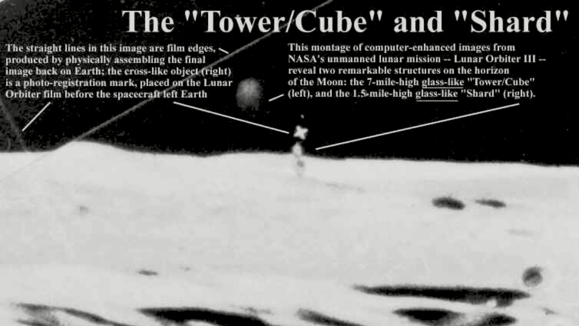
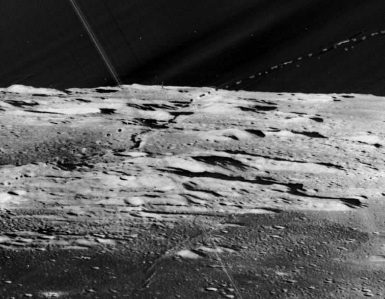
Remember the Shard and Tower on the moon?
page: 1share:
Was looking through photos I've saved over
the years and remembered this one
immediately.
What about you? I'm sure that most of us
remember it, I fondly do. I recall how a photo of this quality was so new and exciting.
Remember Mars anomaly research site?
Still saddens me to see that he past away,
he never did give us info or thoughts on
Warfare!, was positive we were all dead from some future invasion.
Rambling, lol...
So...does anyone know where on the moon
these two areas are supposedly located?
Anyone ever debunk this, I mean at 7 mile
and 1.5 respectively we should have some
pretty nice pics of these structures with all
the various countries sats reshooting the
planet since then. Lol
I know I could of GOOGLED it or searched this
site but was also interested in your feelings of when it was first shown to us, let me know your thoughts, thanks
edit on 1-5-2020 by tayton because: (no reason given)
a reply to: tayton
Funny that you say that, because the above image is of much lower quality than the original, so much so that the tower only appears in the images manipulated by Richard Hoax... uh Hoagland.
The location is near Bruce Crater.
Some more info here..
www.livescience.com...
I recall how a photo of this quality was so new and exciting.
Funny that you say that, because the above image is of much lower quality than the original, so much so that the tower only appears in the images manipulated by Richard Hoax... uh Hoagland.
The location is near Bruce Crater.
Some more info here..
www.livescience.com...
www.tarrdaniel.com...
This image is an overexposed 44x enlargement of Lunar Orbiter frame LO-III-84-M. Taken with the medium resolution camera at a distance of at least 250 miles.
Almost had coordinates for you.. but the website I found was closed down, so I could not enter the site to see the complete coordinates.. so close
a reply to: Chadwickus
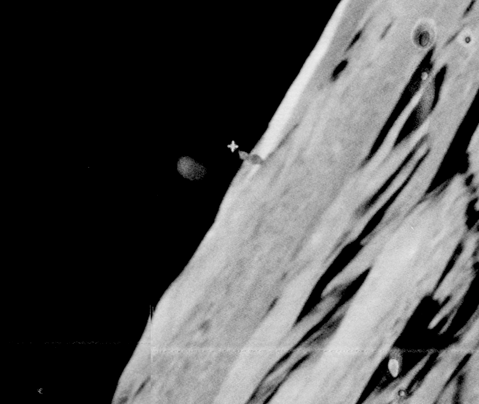
It's still there visible in the non-Hoagland edited photos. It even appears to cast a long shadow.
There is something there but the resolution is crap.
Are there any better pics of this area we can examine? I've been somewhat curious, though skeptical, for a long time about this.
I would like to know what the deal is with it. It's there but what is it? It does seem elevated but again I'd like higher res.
originally posted by: ArMaP
I remember that.
A Google search for "moon shard" and "coordinates" showed me, among other results, this page on ATS.
Here's my post from page 25 of the thread ArMap referenced, plus some new data:
________________________________________________________________
I have [the shard] near 4°23′ S 8°13′ W on the east rim/ejecta blanket of Lalande crater on the near side of the Moon.
Lunar Orbiter III was 46.75km over Sinus Medii when it took the OP photo looking west.
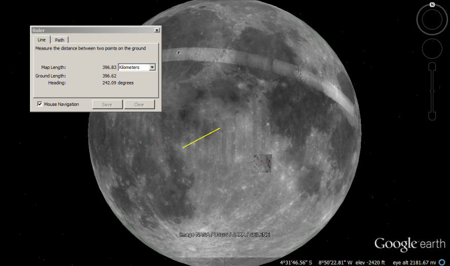
From that altitude, the horizon was ~400km away - just the right distance to Lalande:
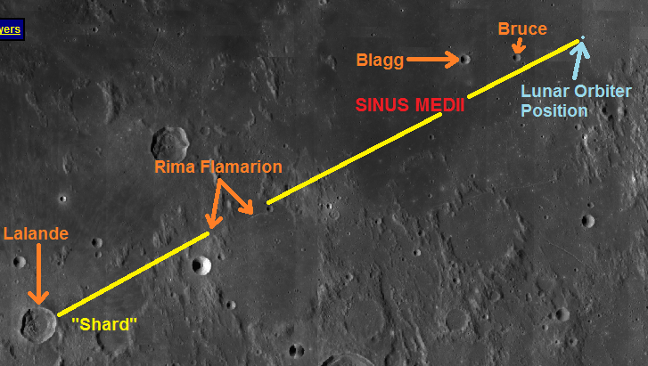
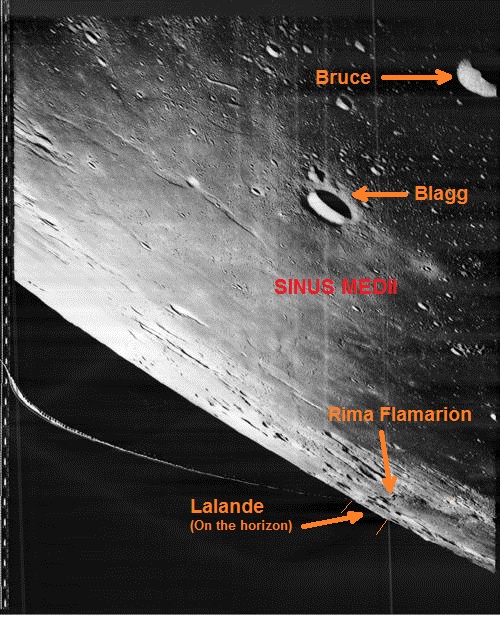
Looking closer, we can see a distinctive rille, Rima Flamarion with the crater Flamarion C at its eastern end:

Here are the two view annotated so that you can match features. Note that Lalande is on the horizon. The yellow line runs from Flamarion C to the area of the "Shard".
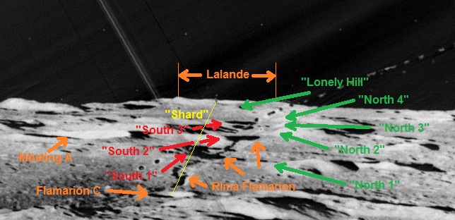
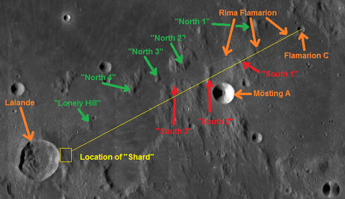
(Note: Sorry for the sloppy annotation. It was a rush-job)
Apollo 12 & 14 both took 70mm Hasselblad images of the area. Apollo 16 took a bunch with its large-format Mapping (Metric) camera. I wanted to annotate thumbnails of these, but I'm out of time. Lalande is easy to find, based on the above images.
AS12-50-7435 (East is up)
AS14-70-9808 (East is to the lower left)
AS14-70-9809 (East is to the lower left)
The Mapping camera images have a zoom-able interface. East is to the right in all of them:
AS16-M-0847
AS16-M-0848
AS16-M-0849
AS16-M-0850
AS16-M-0851
AS16-M-1410
AS16-M-1411
AS16-M-1412
AS16-M-1413
AS16-M-1414
AS16-M-1415
AS16-M-1416
I misspoke earlier. LROC has imaged the area with its Wide Angle Camera...

...but it hasn't yet imaged the eastern rim & ejecta blanket with the Narrow Angle Camera.
___________________________________________________________________
Since that post (7 years ago), LROC has imaged those coordinates several times:
M1127185486LE
M1127185486LC
M1169579935RE
M1169579935RC
M1200185930LE
M1200185930LC
M1246065140RE
M1246065140RC
M1295446281RE
M1295446281RC
(Resolution is 0.8 - 1.9 meters per pixel)
edit on 1-5-2020 by Saint Exupery because: Added clarifying information
a reply to: Saint Exupery
So your conclusion must be the object in question have to be mobile ?
Or
Someone have edited the pictures before or after.. ?
Because clearly there is something there in the picture.. the "star" above is a camera effect to show size of things.. but the shard have to have a story to.
So your conclusion must be the object in question have to be mobile ?
Or
Someone have edited the pictures before or after.. ?
Because clearly there is something there in the picture.. the "star" above is a camera effect to show size of things.. but the shard have to have a story to.
edit on 1-5-2020 by Spacespider because: (no reason given)
Ye, that's a tower right, not sure about the "shard", but for the tower, maybe natural?
a reply to: Spacespider
Or that it isn't there at all and never was, and that it is merely a product of an image having been taken, developed and scanned in lunar obit and then transmitted back to Earth with all the possible sources of error that implies.
A 600 Mb .IMG format version of the image is available here
pds-imaging.jpl.nasa.gov...
You can also look at the same area in Chinese and Japanese photos. There will be no shard.
edit on 1/5/2020 by OneBigMonkeyToo because: correct
file link
a reply to: tayton
Given that every college with an astronomy department has been eyeballing the surface of the moon for decades, plus China and India have both been their recently, if this thing was a real megastructure, it would have been found a long long time ago.
Given that every college with an astronomy department has been eyeballing the surface of the moon for decades, plus China and India have both been their recently, if this thing was a real megastructure, it would have been found a long long time ago.
originally posted by: Spacespider
www.tarrdaniel.com...
This image is an overexposed 44x enlargement of Lunar Orbiter frame LO-III-84-M. Taken with the medium resolution camera at a distance of at least 250 miles.
Almost had coordinates for you.. but the website I found was closed down, so I could not enter the site to see the complete coordinates.. so close
The remainder of that sites coordinates are: "the images may be viewed on Google Moon by entering the coordinates Long: 73° 08′ 30 S Lat: 145° 40′ 40 W.".
www.tarrdaniel.com...
Thanks guys! Appreciate all replies, what a time things were back then, now, not so much
a reply to: Spacespider
To be fair it does need some specialist software to view (or at least know how to load it in Photoshop properly), so here's the relevant bit:

To be fair it does need some specialist software to view (or at least know how to load it in Photoshop properly), so here's the relevant bit:
a reply to: OneBigMonkeyToo
You beat be by a few minutes.
(click for full size, 100% zoom crop)
I preferred to show a larger area to show, so we can see that there are several areas with those grey marks.
You beat be by a few minutes.
(click for full size, 100% zoom crop)

I preferred to show a larger area to show, so we can see that there are several areas with those grey marks.
edit on 1/5/2020 by ArMaP because: (no reason given)
a reply to: ArMaP
Nice done.. the one I downloaded did not work, think I downloaded a img file for virtual drive.
Well your picture have me leaning more against bad picture artifacts.. then something there on the moon.
The "shadow" below the bad picture artifact is just a crater I think in the right place, to make it look like a shadow.
a reply to: Spacespider
If you have Photoshop you can open these files by using 'open as', then choosing 'photoshop raw'.
In the box that comes up enter the values in the matching .lbl file, usually 16500 for the height and then the other value for the width.
Another way is to use free software QGIS, which can open the files by dragging in the .lbl file into it. QGIS is great for producing 3D terrain maps from planetary data.
Sometimes the .lbl value they have there has an incorrect width, which results in a corrupt image, but I worked out that if you divide the file size by 16500 (the height seems fixed for lunar orbiter inages), then divide that by 2, you can fix it
IMG files are raw data, and often get used for these type of files, eg the LRO.
a reply to: Spacespider
As OneBigMonkeyToo said, those IMG files are raw data files, following a specific format used by the Planetary Data System. They either have text describing how the data is arranged inside the file or have an associated LBL file with that information. In this case we have an IMG and an LBL file.
I didn't use any of the methods OneBigMonkeyToo mentions, I used NASAView (available here), as it's the fastest way of opening IMG files.
If you have a Linux-based system you can download ISIS (available here). It's not as easy to use as NASAView, but it's a full suite of tools to work with data from all (as far as I know) relatively recent space missions.
Both are free.
new topics
-
Mike Pinder The Moody Blues R.I.P.
Music: 33 minutes ago -
Putin, Russia and the Great Architects of the Universe
ATS Skunk Works: 3 hours ago -
A Warning to America: 25 Ways the US is Being Destroyed
New World Order: 8 hours ago
top topics
-
President BIDEN's FBI Raided Donald Trump's Florida Home for OBAMA-NORTH KOREA Documents.
Political Conspiracies: 13 hours ago, 31 flags -
A Warning to America: 25 Ways the US is Being Destroyed
New World Order: 8 hours ago, 13 flags -
Is AI Better Than the Hollywood Elite?
Movies: 15 hours ago, 4 flags -
Mike Pinder The Moody Blues R.I.P.
Music: 33 minutes ago, 2 flags -
Maestro Benedetto
Literature: 15 hours ago, 1 flags -
Putin, Russia and the Great Architects of the Universe
ATS Skunk Works: 3 hours ago, 1 flags
active topics
-
Alternate Electors vs Fake Electors - What is the Difference.
2024 Elections • 120 • : Threadbarer -
Gaza Terrorists Attack US Humanitarian Pier During Construction
Middle East Issues • 58 • : matafuchs -
Putin, Russia and the Great Architects of the Universe
ATS Skunk Works • 12 • : RussianTroll -
Truth Social goes public, be careful not to lose your money
Mainstream News • 132 • : matafuchs -
New whistleblower Jason Sands speaks on Twitter Spaces last night.
Aliens and UFOs • 67 • : Ophiuchus1 -
Mike Pinder The Moody Blues R.I.P.
Music • 1 • : RussianTroll -
Mood Music Part VI
Music • 3106 • : TheWoker -
University of Texas Instantly Shuts Down Anti Israel Protests
Education and Media • 275 • : Vermilion -
President BIDEN's FBI Raided Donald Trump's Florida Home for OBAMA-NORTH KOREA Documents.
Political Conspiracies • 22 • : 320MPH -
A Warning to America: 25 Ways the US is Being Destroyed
New World Order • 19 • : Cvastar