It looks like you're using an Ad Blocker.
Please white-list or disable AboveTopSecret.com in your ad-blocking tool.
Thank you.
Some features of ATS will be disabled while you continue to use an ad-blocker.
10
share:
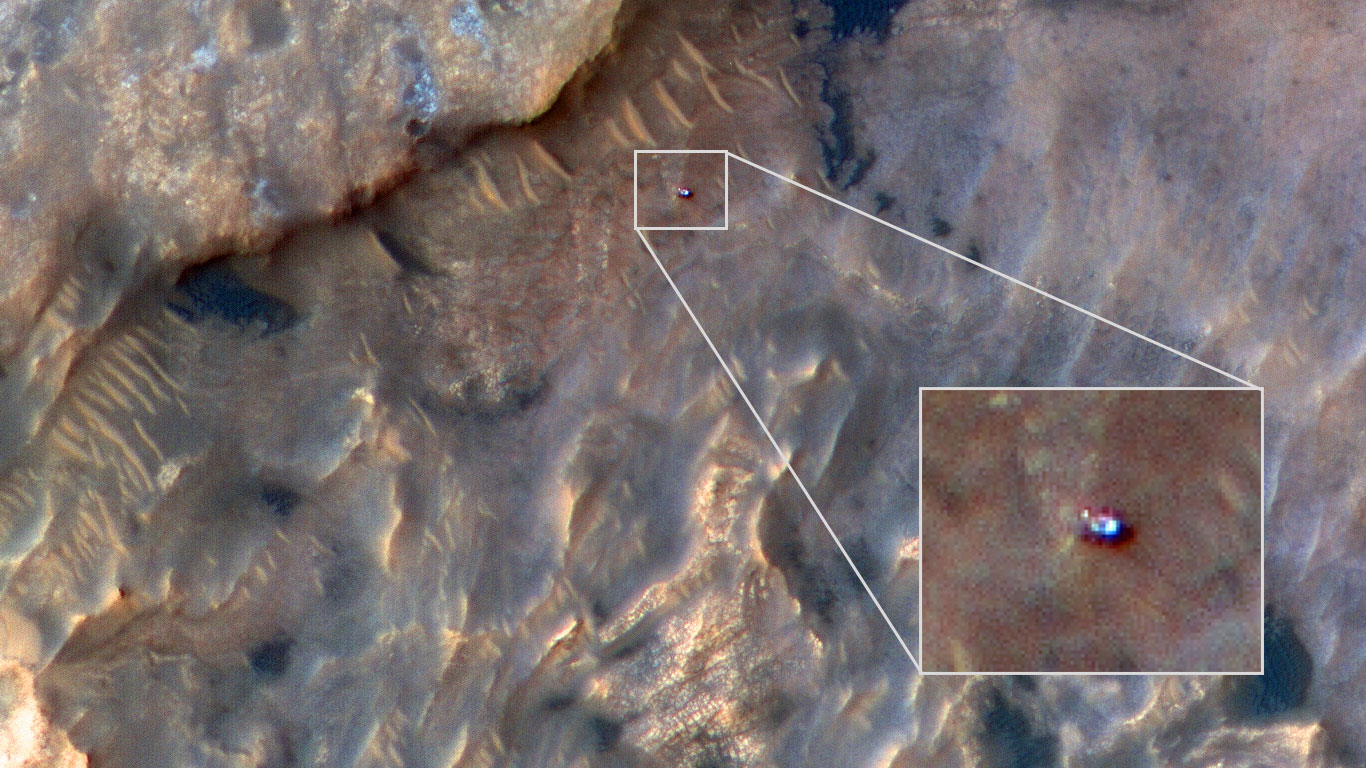
This image of the Curiosity rover was acquired on 31 May 2019, when the rover was examining a location called “Woodland Bay” within a clay-bearing area of Mount Sharp in Gale Crater.
The Vera Rubin ridge is northwest of the rover, while a dark patch of rippled sand lies to the northeast. This may be the best or most interesting image of the rover acquired by HiRISE. What HiRISE detects are mainly specular reflections off of various shiny surfaces, plus shadows of the rover cast onto the Martian surface.
Curiosity Rover at Woodland Bay
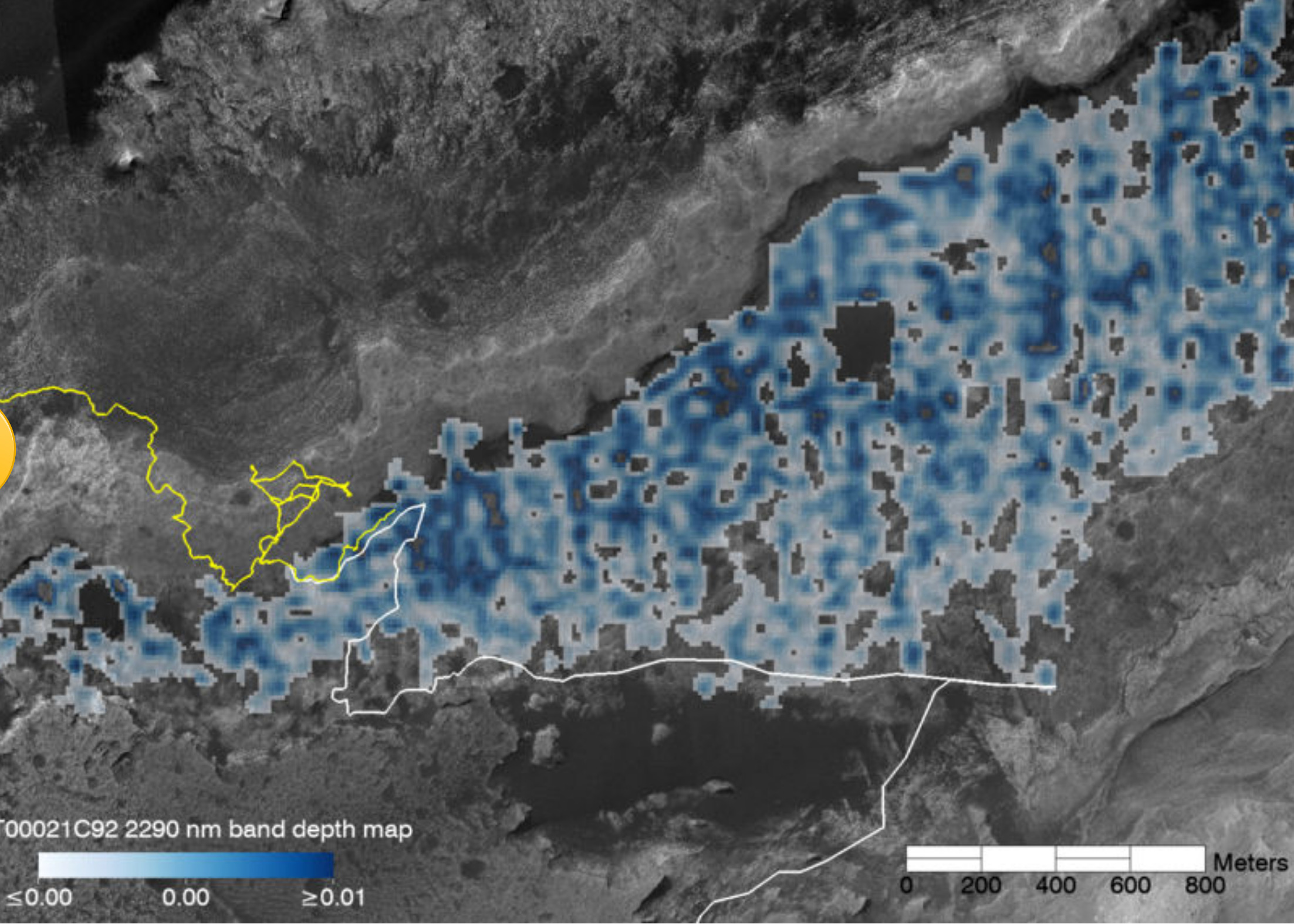
Superimposed on high-resolution image of the base of Mount Sharp is a map made of data from the Mars Reconnaissance Orbiter CRISM instrument. In blue tints, the map shows the strength of a spectral signal attributed to the presence of smectite, a type of clay mineral that suggests the past presence of liquid water. The area with the smectite signal -- informally named Glen Torridon -- also has a distinct rubbly texture. The yellow line shows Curiosity's path up to sol 2366 (3 April 2019). The white path was the plan for Curiosity's future traverse as of sol 2296.
Map of Glen Torridon
Glen Torridon is an interesting name for this clay rich area on Mars.
Glen Torridon On Earth
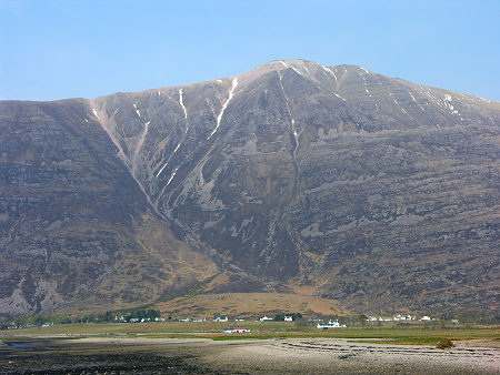
The name "Torridon" is used to describe both an area and a village. The area name Torridon is loosely used to describe the area to the north of Loch Torridon, on both sides of Upper Loch Torridon, and on both sides of Glen Torridon as it heads west and then curves round to the north towards Kinlochewe. You might find that others set its boundaries a little differently: but you'll be hard pressed to find anyone who challenges the view that Torridon contains some of Scotland's most magnificent mountains in a setting that inspires awe and wonder.
Torridon
In the Torridonian, Eohalothece is associated with phosphatic nodules, and we have developed a novel hypothesis linking Eohalothece to phosphate deposition in ancient freshwater settings. Extant cyanobacteria can be prolific producers of extracellular microcystins, which are non‐ribosomal polypeptide phosphatase inhibitors. Microcystins may have promoted the retention and concentration of sedimentary organic phosphate prior to mineralization of francolite and nodule formation. This has a further implication that the Torridonian lakes were nitrogen limited as the release of microcystins is enhanced under such conditions today. The abundance and wide distribution of Eohalothece lacustrina attests to the importance of cyanobacteria as oxygen‐producing photoautotrophs in lacustrine ecosystems at the time of the Mesoproterozoic–Neoproterozoic transition.
non‐marine cyanobacterium from the Torridon Group
Some of the quartzite contains fossilized worm burrows and is known as pipe rock. It is circa 500 million years old. The Torridon landscape is itself highly denuded by glacial and alluvial action, and represents the remnants of an ancient peneplain.
Torridonian
Abstract
The ∼1000 Ma Torridon Group of northwest Scotland are here shown to contain a rich diversity of organic walled microfossils preserved in exceptional detail within sedimentary phosphate. The phosphatic nodules and bands in which they occur are autochthonous, as are the organic fossils they contain. The associated sedimentology of this phosphate is shown to be consistent with a lacustrine setting. Informal taxonomic treatment of the microfossils allows statistical assessment of the relative abundances of different morphotypes across a range of lacustrine environments. Exceptional preservation of pristine organic-walled eukaryotes and prokaryotes, together with a taphonomic spectrum in both physicochemical and biological degradational conditions allows a picture to be built of the earliest lacustrine ecological communities.
Remarkably preserved prokaryote and eukaryote microfossils within 1 Ga-old lake phosphates of the Torridon Group, NW Scotland
The Clay on Mars
This clay-bearing unit on Mars could be one of the most likely areas to have fossils that a Mars rover has ever explored. At some point before the MSL rover entered the clay unit the raw Mars images from the mission that are released to the public changed.
Most all raw Mastcam images were presented to the public in color. Now most images from the Mastcam are bayer images that are presented as black and white in the raw images. They can be converted to color by the public with a little work, but even then the color and resolution are lacking compared to the raw Mastcam M-100 color images that used to be released.
Now the public is lucky to see a few M-34 raw color Mastcam images. Go back 6 months and look at the raw Mastcam images released to the public. You will find almost every raw Mastcam image is in color and a mix of M-34 and M-100(more detailed) images.
If you look now almost every raw Mastcam image is presented to the public in black and white. You will find only a few raw M-34(less detail) images presented to the public in color. It is true you will see plenty of raw high resolution MAHLI images still presented to the public in color. The MAHLI images are targeted images and NASA now has more control over what is presented to the public in the raw high resolution color images of this clay-bearing area on Mars .
Mastcam images before the change
Mastcam images after the change
a reply to: LookingAtMars
That was a fantastic read, thank you. I love that little critter is scuttling around still for us 👍
Edit, I just got back from the links to mars images, wow, thanks again, the color ones are addictive to look at!
That was a fantastic read, thank you. I love that little critter is scuttling around still for us 👍
Edit, I just got back from the links to mars images, wow, thanks again, the color ones are addictive to look at!
edit on 13-7-2019 by Silure
because: To thank for links
I haven't seen any fossils. I think to they're looking in the wrong spot. They need to look more in transitional areas where the potentially fossil
bearing soil isn't completely buried by dead sediment layers that obviously collected more recently.
That's my opinion after looking at this stuff for several years now.
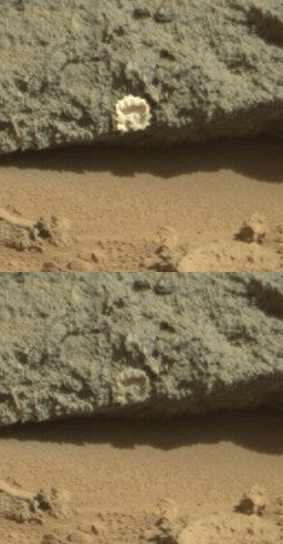
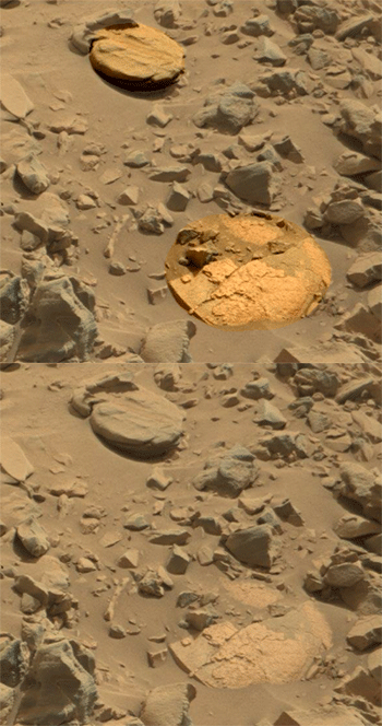
That's my opinion after looking at this stuff for several years now.


edit on 13-7-2019 by Blue Shift because: (no reason given)
a reply to: LookingAtMars
Someday we will have breaking news saying that they found out that Mars was once a blue planet like earth and full of life.
But I guess they will save that news until manned missions, news like that will justify the mission and future missions.
Someday we will have breaking news saying that they found out that Mars was once a blue planet like earth and full of life.
But I guess they will save that news until manned missions, news like that will justify the mission and future missions.
a reply to: Blue Shift
That's a good point. Transitional areas sound like a good easy place to look. I think underground and under some Polar ice would be good places to look too, but harder to look there.
I haven't seen any fossils. I think to they're looking in the wrong spot. They need to look more in transitional areas where the potentially fossil bearing soil isn't completely buried by dead sediment layers that obviously collected more recently.
That's a good point. Transitional areas sound like a good easy place to look. I think underground and under some Polar ice would be good places to look too, but harder to look there.
a reply to: Spacespider
I don't think it will be breaking news. The picture of Mars is slowly changing toward it being Earth-like in it's past. At first it was said it never, ever had water. You are probable right about there being some bombshell info being held back though, until boots on the ground can verify it.
Someday we will have breaking news saying that they found out that Mars was once a blue planet like earth and full of life.
I don't think it will be breaking news. The picture of Mars is slowly changing toward it being Earth-like in it's past. At first it was said it never, ever had water. You are probable right about there being some bombshell info being held back though, until boots on the ground can verify it.
I'd love to see your personal mars favourites! Be totally grateful for any more links like those
originally posted by: LookingAtMars
a reply to: Silure
wow, thanks again, the color ones are addictive to look at!
It's not that I need the color images, I just like them
Thank you
a reply to: Silure
Here are two sites I check about every day.
Midnight Planets
Unmanned Spaceflight
and there is this on Flickr
Here are two sites I check about every day.
Midnight Planets
Unmanned Spaceflight
and there is this on Flickr
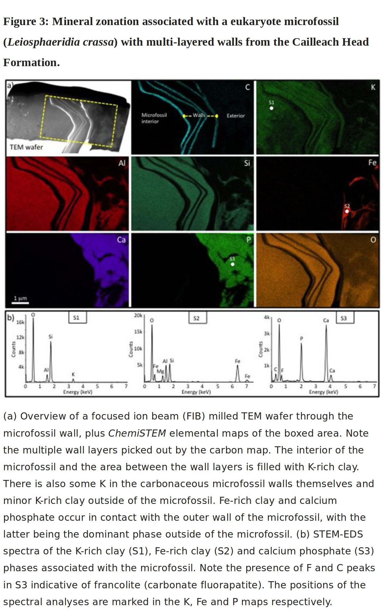
Enhanced cellular preservation by clay minerals in 1 billion-year-old lakes
We here show that 1 billion-year-old microfossils from the non-marine Torridon Group are remarkably preserved by a combination of clay minerals and phosphate, with clay minerals providing the highest fidelity of preservation. Fe-rich clay mostly occurs in narrow zones in contact with cellular material and is interpreted as an early microbially-mediated phase enclosing and replacing the most labile biological material. K-rich clay occurs within and exterior to cell envelopes, forming where the supply of Fe had been exhausted. Clay minerals inter-finger with calcium phosphate that co-precipitated with the clays in the sub-oxic zone of the lake sediments.
Two recent images of layers on Mars.
MAHLI image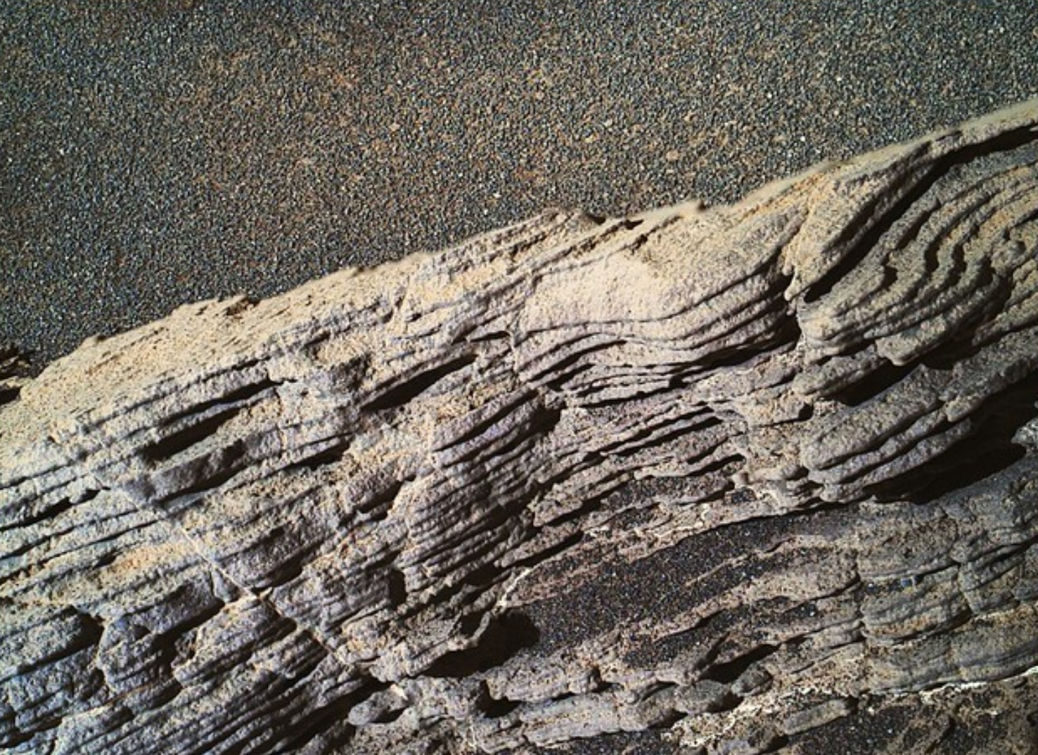
Chemcam image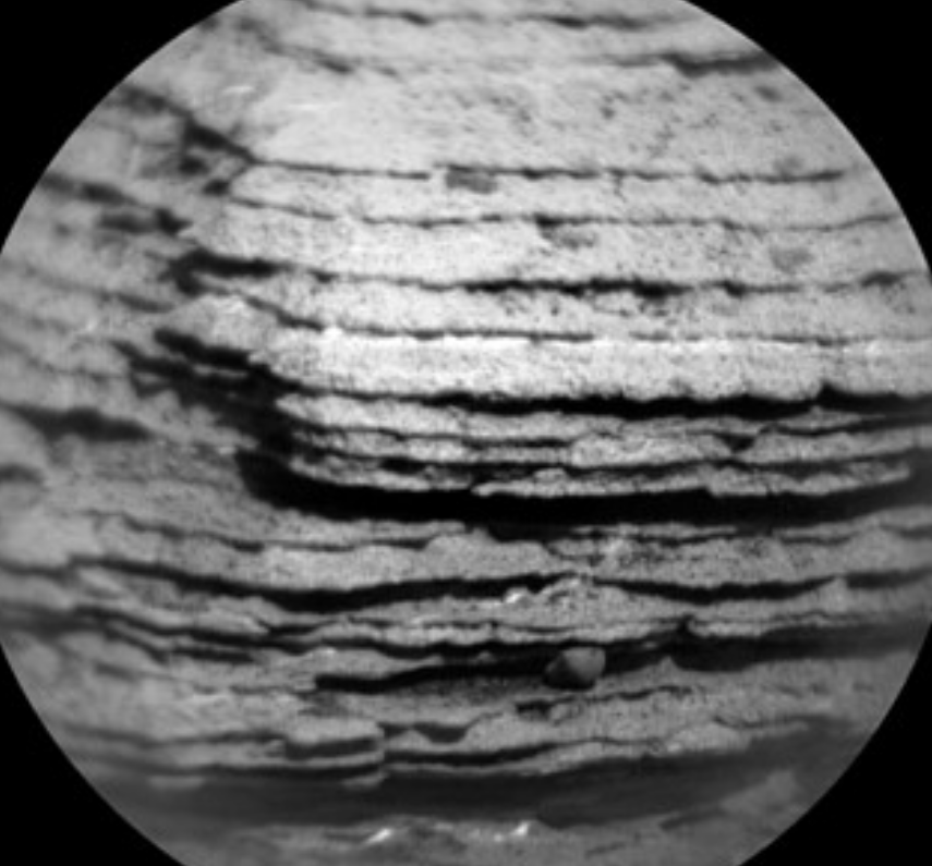
The images were "adjusted" a bit.
MAHLI image

Chemcam image

The images were "adjusted" a bit.
edit on 14-7-2019 by LookingAtMars because: fix link
a reply to: LookingAtMars
if your first image is not sedimentary rock then everything I see in local cliff formations is a lie, or I'm living in some crazy matrix world of deception!
if your first image is not sedimentary rock then everything I see in local cliff formations is a lie, or I'm living in some crazy matrix world of deception!
a reply to: LookingAtMars
All I see here is silt/sandstone, or shale rock
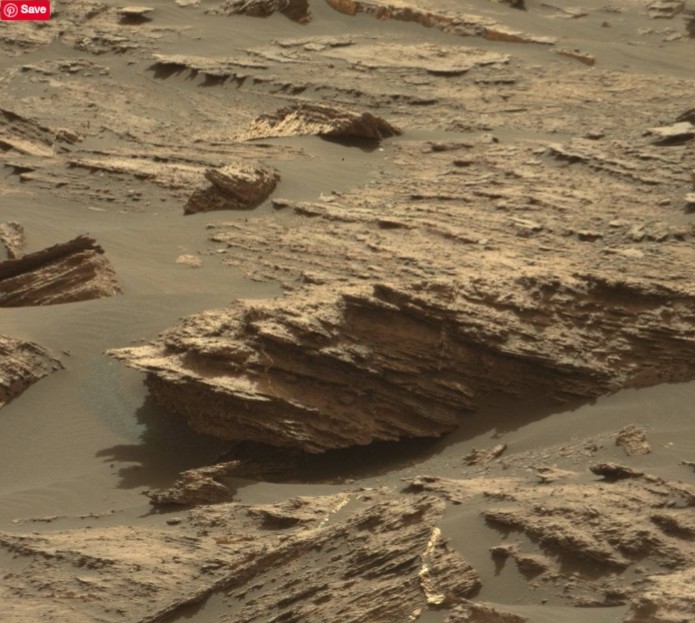
Thanks for posting this thread, I've looked at some amazing pictures so far and all the geo formations seem to me to be pretty much the same as on Earth and involving liquid processes 👍
I would so love to go there, at a later stage in my life now that I wouldn't care if it was a one way trip.
All I see here is silt/sandstone, or shale rock

Thanks for posting this thread, I've looked at some amazing pictures so far and all the geo formations seem to me to be pretty much the same as on Earth and involving liquid processes 👍
I would so love to go there, at a later stage in my life now that I wouldn't care if it was a one way trip.
It's worth pointing out that just because something is a sedimenatry rock it does not necessarily make it a life bearing medium, or even a home for
fossiliswd remants. It's far more significant here as a way of interpreting the depositional environment and the very obvious presence of water in
Mars' ancient past.
Torridon is a beautiful part of the world (both of them )
e2a: I should also add the caveat that aolian deposition can make layered sedimentary deposits without water!
Torridon is a beautiful part of the world (both of them )
e2a: I should also add the caveat that aolian deposition can make layered sedimentary deposits without water!
edit on 15/7/2019 by
OneBigMonkeyToo because: (no reason given)
a reply to: OneBigMonkeyToo
This has been a great thread for me, I'd never heard of aolian deposition before so have spent the last half hour reading something new
I can definitely see it's effects in mars (and titan) pictures, but if I had a gun to my head for an answer about the pic above for example, my life would have to be staked on seabed type formation of sandstone.
I actually joined up for these types of threads and I'm glad I did, seems a bit quiet here than on political threads but at least there's no arguing
originally posted by: OneBigMonkeyToo
e2a: I should also add the caveat that aolian deposition can make layered sedimentary deposits without water!
Quite so. My hometown is known for its loess bluffs; rich topsoil blown in from somewhere else. Not deposited by water.
originally posted by: Silure
a reply to: OneBigMonkeyToo
I actually joined up for these types of threads and I'm glad I did, seems a bit quiet here than on political threads but at least there's no arguing
They don't argue or debate over there, they just insult with tired old names.
originally posted by: OneBigMonkeyToo
It's worth pointing out that just because something is a sedimenatry rock it does not necessarily make it a life bearing medium, or even a home for fossiliswd remants. It's far more significant here as a way of interpreting the depositional environment and the very obvious presence of water in Mars' ancient past.
Torridon is a beautiful part of the world (both of them )
e2a: I should also add the caveat that aolian deposition can make layered sedimentary deposits without water!
The big volcanoes could of laid down some layers for sure. Not sure clay can deposit from the air though.
new topics
-
A Bunch of Maybe Drones Just Flew Across Hillsborough County
Aircraft Projects: 4 hours ago -
Who's coming with me?
General Conspiracies: 5 hours ago -
FBI Director CHRISTOPHER WRAY Will Resign Before President Trump Takes Office on 1.20.2025.
US Political Madness: 9 hours ago -
The NIH is still sending taxpayer money to Chinese Labs to Conduct cruel animal experiments
Mainstream News: 9 hours ago -
Angela Merkel is terrified of dogs
Politicians & People: 11 hours ago
top topics
-
The NIH is still sending taxpayer money to Chinese Labs to Conduct cruel animal experiments
Mainstream News: 9 hours ago, 12 flags -
FBI Director CHRISTOPHER WRAY Will Resign Before President Trump Takes Office on 1.20.2025.
US Political Madness: 9 hours ago, 9 flags -
A Bunch of Maybe Drones Just Flew Across Hillsborough County
Aircraft Projects: 4 hours ago, 7 flags -
Will all hell break out? Jersey drones - blue beam
Aliens and UFOs: 17 hours ago, 5 flags -
Who's coming with me?
General Conspiracies: 5 hours ago, 4 flags -
Angela Merkel is terrified of dogs
Politicians & People: 11 hours ago, 3 flags
active topics
-
Will all hell break out? Jersey drones - blue beam
Aliens and UFOs • 39 • : Arbitrageur -
A Bunch of Maybe Drones Just Flew Across Hillsborough County
Aircraft Projects • 13 • : nugget1 -
Who's coming with me?
General Conspiracies • 26 • : BingoMcGoof -
Drones everywhere in New Jersey
Aliens and UFOs • 66 • : imitator -
-@TH3WH17ERABB17- -Q- ---TIME TO SHOW THE WORLD--- -Part- --44--
Dissecting Disinformation • 3622 • : WeMustCare -
From the MUSK-RAMASWAMY Department of Government Efficiency commission - DOGE.
Above Politics • 59 • : WeMustCare -
And Here Come the Excuses!!
General Conspiracies • 156 • : cherokeetroy -
President-Elect DONALD TRUMP's 2nd-Term Administration Takes Shape.
Political Ideology • 296 • : WeMustCare -
The Reactionary Conspiracy 3. Objectives
General Conspiracies • 60 • : Solvedit -
Salvatore Pais confirms science in MH370 videos are real during live stream
General Conspiracies • 241 • : b0kal0ka
10

