It looks like you're using an Ad Blocker.
Please white-list or disable AboveTopSecret.com in your ad-blocking tool.
Thank you.
Some features of ATS will be disabled while you continue to use an ad-blocker.

Atlantis has been discovered?!
page: 25share:
originally posted by: All Seeing Eye
originally posted by: Byrd
originally posted by: All Seeing Eye
Sarah Parcak, archaeologist of the University of Alabama (@indyofspace) has confirmed the rectangular structures of the Richat are ancient. 5000-8000 years.
Though she does not get into great detail about how this structure happens to be there. I suspect it was built post flood. She does not discuss the buried structure, pre flood.
"Atlas of Cursed Places S1 E2
Perhaps you could ask her what she means by "ancient." I suspect "about 1100 AD" is the answer.
Again, this appears to be built post flood. There are actually two of these forts in the center Island. 21° 7'23.06"N 11°22'22.11"W 21° 5'25.83"N 11°27'12.39"W A third one is also present but because of its condition may be pre or post flood. 21° 3'35.60"N 11°26'29.31"W
5000 - 8000 years. If you disagree with her conclusion, you are free to contact her.
I do hope you are not Multimedia impaired...
2 min 30 sec. In her own words.
She calls them animal pens and says they could have housed more than a hundred camels or donkeys. However, if it's camel pens then they didn't get camels until around 1500 BC (that's when the Arabian camels came into Africa and became a standard beast of burden.)
Yes, she does give that date range, however that was not from direct examination of the area but rather from looking at secondhand evidence; satellite photos. There's grounds to dispute her age range.
So we would agree (she and I) that they're animal pens -- but disagree on the age. We'd ask someone who'd dug the area about them.
a reply to: Byrd
I'm not really concerned with the "Forts" she pointed out or even their age, and it true as you point out, to get a accurate age they would have to be inspected in person to gain samples.
My main concern is how did the buried structures get buried, and what are their age's. And that will defiantly require a
"dig".
5000 - 8000 years? I'm good with that. Sounds like a good starting point for me. It puts it into the African Human Period.
en.wikipedia.org...
Yes, she does give that date range, however that was not from direct examination of the area but rather from looking at secondhand evidence; satellite photos. There's grounds to dispute her age range.
I'm not really concerned with the "Forts" she pointed out or even their age, and it true as you point out, to get a accurate age they would have to be inspected in person to gain samples.
My main concern is how did the buried structures get buried, and what are their age's. And that will defiantly require a
"dig".
5000 - 8000 years? I'm good with that. Sounds like a good starting point for me. It puts it into the African Human Period.
en.wikipedia.org...
originally posted by: Byrd
She calls them animal pens and says they could have housed more than a hundred camels or donkeys. However, if it's camel pens then they didn't get camels until around 1500 BC (that's when the Arabian camels came into Africa and became a standard beast of burden.)
Yes, she does give that date range, however that was not from direct examination of the area but rather from looking at secondhand evidence; satellite photos. There's grounds to dispute her age range.
So we would agree (she and I) that they're animal pens -- but disagree on the age. We'd ask someone who'd dug the area about them.
I wonder if she actually meant 500 to 800 years ago? Which would make sense. But yes, you can no more date those pens from a satellite image that you can tell how many cups of tea I drank this morning based on the number of times I've posted comments on ATS this week.
originally posted by: AndyMayhew
originally posted by: Byrd
She calls them animal pens and says they could have housed more than a hundred camels or donkeys. However, if it's camel pens then they didn't get camels until around 1500 BC (that's when the Arabian camels came into Africa and became a standard beast of burden.)
Yes, she does give that date range, however that was not from direct examination of the area but rather from looking at secondhand evidence; satellite photos. There's grounds to dispute her age range.
So we would agree (she and I) that they're animal pens -- but disagree on the age. We'd ask someone who'd dug the area about them.
I wonder if she actually meant 500 to 800 years ago? Which would make sense. But yes, you can no more date those pens from a satellite image that you can tell how many cups of tea I drank this morning based on the number of times I've posted comments on ATS this week.
How many folks do you think it took to build those 3 forts, Regardless of how old. How long do you think it took them.
a reply to: AndyMayhew
I'm wondering what your mixing in you tea lol She seems pretty certain about the age. Are you too Multimedia impaired?
Again...
ADDED: She also shows a image of those "Building Blocks" outside the southern opening. Horrible image she used. Mine are much better lol.
I wonder if she actually meant 500 to 800 years ago?
I'm wondering what your mixing in you tea lol She seems pretty certain about the age. Are you too Multimedia impaired?
Again...
ADDED: She also shows a image of those "Building Blocks" outside the southern opening. Horrible image she used. Mine are much better lol.
edit on AMWednesdayWednesday thAmerica/ChicagoAmerica/Chicago28911 by All Seeing Eye because: (no reason given)
a reply to: AndyMayhew
To help you visualize the size of these "Forts". They ARE Substantial.
21° 5'25.83"N 11°27'12.39"W
21° 7'23.06"N 11°22'22.11"W
21° 3'35.60"N 11°26'29.31"W
To help you visualize the size of these "Forts". They ARE Substantial.
21° 5'25.83"N 11°27'12.39"W
21° 7'23.06"N 11°22'22.11"W
21° 3'35.60"N 11°26'29.31"W
originally posted by: All Seeing Eye
a reply to: Byrd
My main concern is how did the buried structures get buried, and what are their age's. And that will defiantly require a
"dig".
The're in the Sahara. it's full of sand and sandstorms (again, I can cite West Texas but folks from Arizona and New Mexico can also chime in with this.) It doesn't take long for sand to drift over and bury them.
Also... I'm not sure that they're really buried. Animal pens aren't that tall; donkeys and camels aren't notorious for jumping skills. I suspect the walls are less than four feet tall. I believe that what you're seeing is sand drifting up against the pen.
originally posted by: All Seeing Eye
a reply to: AndyMayhew
To help you visualize the size of these "Forts". They ARE Substantial.
21° 5'25.83"N 11°27'12.39"W
21° 7'23.06"N 11°22'22.11"W
21° 3'35.60"N 11°26'29.31"W
I appreciate the measurements... but if (as the archaeologist said) they're animal pens, that's enough for a caravan's worth of camels. If the round structures are watering troughs, and the pen is near a well, then the most likely explanation is that this is a regular stop for caravans.
Now, to my mind that makes more sense than a fort. I don't see any gates (you need to get in and out of forts, and you need several entrances because only an idiot walls himself up someplace with only one door) There's no signs of other buildings inside these structures and you don't build walls and then not set up a building for cooking, middens for bathrooms, trenches, and a lot of other things (along with a road for supplies.)
SO -- I think the post that I found that originally identified them as forts is wrong... that the poster (on Reddit or G-earth forums) confused the animal pens with the other triangular structures you found (the very modern-looking ones) and labeled these "forts" incorrectly. I now agree with the archaeologist that animal pens makes a lot more sense, particularly given the lack of other features and the very crude layout design.
And I think the round circles are the remains of wells. If the area is over an aquifer or near a dried up oasis (which is plausible) then shallow wells for watering the animals makes sense there. The round things are so small that you could only have one or two people in it (if they were friendly and skinny.)
edit on 15-9-2021 by Byrd because: (no reason given)
originally posted by: All Seeing Eye
a reply to: AndyMayhew
I wonder if she actually meant 500 to 800 years ago?
I'm wondering what your mixing in you tea lol She seems pretty certain about the age. Are you too Multimedia impaired?
Again...
ADDED: She also shows a image of those "Building Blocks" outside the southern opening. Horrible image she used. Mine are much better lol.
There's no need to be rude to Andy... a fair question was asked. Yes, she stated an age but in the same section she also indicates that these are pens for donkeys an camels.
Andy's correct to raise the question and ask if that's actually her opinion or if the interview is a much longer piece that's been cut and spliced to give a different idea. As an Egyptologist, she absolutely would know when camels came to North Africa and the idea of her saying that there's an 8,000 year old camel pen just doesn't make sense. Camels were domesticated a mere 3,000-3500 years ago and donkeys were domesticated only 6,000 years ago (so... about 1500 BC and around 4,000 BC).
And she'd know that from her Egyptological work.
So... curious anomaly in the interview, there.
originally posted by: Byrd
originally posted by: All Seeing Eye
a reply to: Byrd
My main concern is how did the buried structures get buried, and what are their age's. And that will defiantly require a
"dig".
The're in the Sahara. it's full of sand and sandstorms (again, I can cite West Texas but folks from Arizona and New Mexico can also chime in with this.) It doesn't take long for sand to drift over and bury them.
Also... I'm not sure that they're really buried. Animal pens aren't that tall; donkeys and camels aren't notorious for jumping skills. I suspect the walls are less than four feet tall. I believe that what you're seeing is sand drifting up against the pen.
You just gave my brain a bruise. I have spent considerable amounts of time out west. Arizona, New Mexico, and Oklahoma. Both Arizona and New Mexico are considered Vegetation Deserts. Oklahoma might as well be, considered the same. Each Region is unique as all the rest in the west. Though sandy for the most part you can see the differences in it from region to region. Its home grown in that region. (Note: If you want a green lawn in Tucson, you have to paint your stones, green)
Of interest, in Tucson I went 2 years without a drop of rain, even though, it rained on the other side of the road, 20ft away. There, a storm cloud will form in one spot, and it will rain only below that one cloud. Though during the monsoon season they can get very local floods in the washes that can be very destructive moving unbelievable amounts of real estate. The soil is mostly Caliche which is a mixture of clay and gravel which is perfect for making mud brick which was a common building material in years past. There were dust storms, but not sand. Even though blowing sand can be seen it isn't very common.
Mauritania on the other hand is a full fledged desert with approx 3mm rainfall a year. I have seen marks in the ground, no sand area that showed a "Dust Devil" passed over. Dust Devil The sand in Mauritania is only in certain areas, and others completely void. The blowing sand generally follows the trade wind direction, generally From the North East to the South West, and generally in low areas. The Mountains to the north of the eye are generally devoid of large sanded areas, but instead have a layer of dirt, with wind blown sand in places.
The Eye itself when compared to other areas have little sand in it and what is there is wind blown, into it. The area to the north east of the eye (Direction from which sand would normally expected to migrate, track, from) is generally free of the sand and covered in brown topsoil.
Typical area of buried structures.
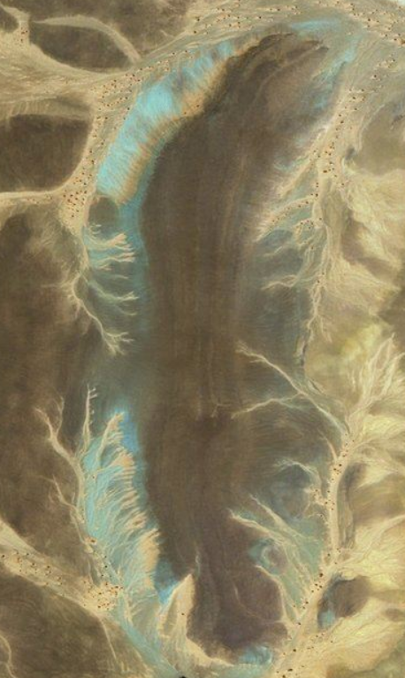
Note the ribbon effect in the brown area. Each ribbon is of a slightly different hue from the other. The Ribbon effect is a individual wave of top soil/silt mud being pushed by the previous. The Viscosity seems to be of the constancy of fairly thin concrete. You will also note the wispy veins of sand, on top.
My conclusion is these structures are buried in topsoil,silty, mud. Not sand. Sand blows over the tops of them, but not buried in sand.
This "Flood" event is similar to the "Pillar" rain of AZ, but, much much, MUCH, larger.
a reply to: Byrd
This was a production for TV, for profit. As you can see they did not spend a lot of time going over all the hundreds of "Objects" she must have discovered. And no doubt, a script, with limits. If she/they, the writers were sincere about the eye there would have been some coverage of the buried structures. But if they did that, there wouldn't be any reason to produce the following episodes. So, I would assume monetary concerns are placed over factualality.
For the "Forts", there are very small openings in the walls. I was able to zoom in and measure. 2-3 ft. Not very large. I doubt its large enough for a pack animal to enter.
As I pointed out, these fort structures had to be built after the flood event that buried the structures on the second ring. The amount of water that would have been required would have wiped everything off of the surrounding area. Also note, these forts are built on the bedrock, not soil, as the soil would have also been removed. Possibly the same top soil that buried the structures. The normal color of top soil in this area, is brown.
Again, she placed the structures in the African humid period. And again, water is the key. Logically these structures, if built as livestock pens, would have been built close to a water supply. Next to a wet wadi would have been far more logical than where we find them. Placing them there as livestock pens, I believe insults the intelligence of the builders. If they are Forts placed in strategic locations, then, water would not be the main issue. And then you have the reason as to why caravans would consider stopping here, a place without water. What is there, what resource would draw them there in the first place?
Andy's correct to raise the question and ask if that's actually her opinion or if the interview is a much longer piece that's been cut and spliced to give a different idea. As an Egyptologist, she absolutely would know when camels came to North Africa and the idea of her saying that there's an 8,000 year old camel pen just doesn't make sense. Camels were domesticated a mere 3,000-3500 years ago and donkeys were domesticated only 6,000 years ago (so... about 1500 BC and around 4,000 BC).
And she'd know that from her Egyptological work.
So... curious anomaly in the interview, there.
This was a production for TV, for profit. As you can see they did not spend a lot of time going over all the hundreds of "Objects" she must have discovered. And no doubt, a script, with limits. If she/they, the writers were sincere about the eye there would have been some coverage of the buried structures. But if they did that, there wouldn't be any reason to produce the following episodes. So, I would assume monetary concerns are placed over factualality.
For the "Forts", there are very small openings in the walls. I was able to zoom in and measure. 2-3 ft. Not very large. I doubt its large enough for a pack animal to enter.
As I pointed out, these fort structures had to be built after the flood event that buried the structures on the second ring. The amount of water that would have been required would have wiped everything off of the surrounding area. Also note, these forts are built on the bedrock, not soil, as the soil would have also been removed. Possibly the same top soil that buried the structures. The normal color of top soil in this area, is brown.
Again, she placed the structures in the African humid period. And again, water is the key. Logically these structures, if built as livestock pens, would have been built close to a water supply. Next to a wet wadi would have been far more logical than where we find them. Placing them there as livestock pens, I believe insults the intelligence of the builders. If they are Forts placed in strategic locations, then, water would not be the main issue. And then you have the reason as to why caravans would consider stopping here, a place without water. What is there, what resource would draw them there in the first place?
originally posted by: All Seeing Eye
The sand in Mauritania is only in certain areas, and others completely void. The blowing sand generally follows the trade wind direction, generally From the North East to the South West, and generally in low areas. The Mountains to the north of the eye are generally devoid of large sanded areas, but instead have a layer of dirt, with wind blown sand in places.
I agree. But the area is also the source of major dust storms that reach all the way here to America.
Now... since you know Arizona and the Southwest, you're familiar with dust storms and how they can cover things with sandy dust. I'm sure you've seen them cover roads and pile dirt/sand up against buildings during just a single storm. We all go out and clear off the dust from our possessions, but abandoned towns (ghost towns) and other structures can be clogged or buried by these far-ranging geological products.
That's what I'm saying has happened to the cattle pens.
The Eye itself when compared to other areas have little sand in it and what is there is wind blown, into it. The area to the north east of the eye (Direction from which sand would normally expected to migrate, track, from) is generally free of the sand and covered in brown topsoil.
Ehhhhhhh.... somewhat agree. A map of the soils of Mauritania -- note... key is not in that image but is found here is an arenosol (definition: arenosol - a soil type consisting mainly of sand with very little organic matter and supporting limited amounts of specialized vegetation.)
There's also leptosoils ( a very shallow soil over hard rock or a deeper soil that is extremely gravelly and/or stony) -- but what you are NOT seeing is organic rich soils from a former huge lake or waterway.
So these soils do produce dust storms on a regular basis, and we all know how that stuff piles up.
Note the ribbon effect in the brown area. Each ribbon is of a slightly different hue from the other. The Ribbon effect is a individual wave of top soil/silt mud being pushed by the previous.
Soils don't work like that. Those are bedding planes where the exposed rock is tilted upward and an unconformity is likely forming.
You are seeing ridges of harder stone alternating with softer material and both were deposited over a period of millions of years.
The light blue appears to be seasonal water.
The Viscosity seems to be of the constancy of fairly thin concrete. You will also note the wispy veins of sand, on top.
I see runoff and sandy material washing down wadis into a small depression (valley but not much of a valley).
My conclusion is these structures are buried in topsoil,silty, mud.
Geologic surveys disagree with your conclusion and tend to support my observation that these cattle pens are being slowly buried in sand unless/until someone comes along and clears the sand for temporary use.
a reply to: All Seeing Eye
I kept trying to tell you that you cant use satellites to do archeology. Things look different on the ground what you see as the eye on the ground is slight hills. You could be in it and not even know you were
www.forbes.com...
I kept trying to tell you that you cant use satellites to do archeology. Things look different on the ground what you see as the eye on the ground is slight hills. You could be in it and not even know you were
www.forbes.com...
edit on 9/16/21
by dragonridr because: (no reason given)
originally posted by: All Seeing Eye
a reply to: Byrd
This was a production for TV, for profit. As you can see they did not spend a lot of time going over all the hundreds of "Objects" she must have discovered. And no doubt, a script, with limits. If she/they, the writers were sincere about the eye there would have been some coverage of the buried structures. But if they did that, there wouldn't be any reason to produce the following episodes. So, I would assume monetary concerns are placed over factualality.
We agree on this... and that they're not going to show her saying anything that discounts their idea or their theme.
For the "Forts", there are very small openings in the walls. I was able to zoom in and measure. 2-3 ft. Not very large. I doubt its large enough for a pack animal to enter.
Err... just how wide do you think a donkey or a camel is? Our kitchen doorway is 3 feet wide, and I'm confident a donkey can walk through it. Ditto a camel.
The identity of them as animal pens explains why there aren't any buildings or other structures inside the walls.
As I pointed out, these fort structures had to be built after the flood event that buried the structures on the second ring. The amount of water that would have been required would have wiped everything off of the surrounding area. Also note, these forts are built on the bedrock, not soil, as the soil would have also been removed. Possibly the same top soil that buried the structures. The normal color of top soil in this area, is brown.
The geology doesn't support this. There's no evidence of a sudden massive flood (those events leave the earth looking like the Scablands). And if someone is rebuilding a fort, even from scratch, they go with the standard plan that they used before the original fort was destroyed. They don't suddenly forget how to construct buildings (and discard all their tools.)
Those cattle pens are VERY primitive. There's no straight angles, no thick walls, etc, or anything typical of a fort.
Again, she placed the structures in the African humid period.
She did. If they ARE that old (which I doubt) they would have been pens for goats (which were domesticated in that area of Africa during that time period.
And again, water is the key. Logically these structures, if built as livestock pens, would have been built close to a water supply. Next to a wet wadi would have been far more logical than where we find them.
They seem to have wells associated with them, which indicates an aquifer or at least an old (and now vanished) water source such as an oasis. Also, wadis are seasonal.
Placing them there as livestock pens, I believe insults the intelligence of the builders. If they are Forts placed in strategic locations, then, water would not be the main issue.
It would be a far greater issue. Instead of a temporary holding area during a season, you would be looking at a permanent establishment with a constant need for food (no farming areas next to them that I see) and a constant need for water for personnel and any animals they have with them.
And then you have the reason as to why caravans would consider stopping here, a place without water. What is there, what resource would draw them there in the first place?
Travel time, for one. Caravans aren't trains and can't travel nonstop.
You're seeing these images from afar (more than 20 miles overhead) during the year 2021. You aren't seeing the area at the ground, doing a soil profile, or seeing it from the air during the year 1021. A thousand years ago, the place looked different.
There's leptosols and regosols, but no direct evidence of an enormous flood. While paleosoils are eroded and redistributed, the other evidence isn't there that indicates Richat is anything but a collapsed dome nor is there an indication that anything as extensive as a city was built in it or on it.
originally posted by: dragonridr
a reply to: All Seeing Eye
I kept trying to tell you that you cant use satellites to do archeology. Things look different on the ground what you see as the eye on the ground is slight hills. You could be in it and not even know you were
www.forbes.com...
That's an interesting article, and I loved the photo of him standing in the middle of the Eye with flat-ish ground all around. And the photo of Ouidane... timeless ruined place.
originally posted by: dragonridr
a reply to: All Seeing Eye
I kept trying to tell you that you cant use satellites to do archeology. Things look different on the ground what you see as the eye on the ground is slight hills. You could be in it and not even know you were
www.forbes.com...
During the Civil War balloons were used for "Spotting". WW1 Balloons were used for "Spotting". WW2 we used Bird dog aircraft for "Spotting". Now, today, we use Satellites for "Spotting". Its called "Reconnaissance". You recon a area for information. And how you use that information depends solely on your mission.
I never claimed to be a archeologist. All I have done is produce a list of targets for Archeologists, once transit into the area can be accomplished. All I am, is a "Spotter".
Its funny, I'm being told that I'm not qualified to produce this list because I'm not on the ground there, by people, who are also, not on the ground there. There is a special word for folks like that.
On the other hand, debate about the "Target" is a healthy thing. What it is, what it was, what it actually is, what it actually was, for each individual target is very acceptable. But shooting down the Balloon and its spotter, is a act which stands out as a act of censorship, at minimum, at most, an act of a enemy.
Now, we have a archeologist who claims to be a SatAch. Your argument is with her, not me. I had already identified those targets, and many more. For all I know she based her observations on mine, and in truth, it matters not to me. Because the list I produce is, FREE to the World! If she took payment for her "Observations", then she is owned by the money, not me! I am free to point out what ever i wish, not so with her. Her goal is to make money. Mine, is to find the truth!
If I were independently wealthy, I would have already found a way to accomplish the mission. I would approach the Mauritanian Government with a proposition of a new contract that as a provision nullifies the one they hold with UNESCO. Etc......
But, I'm not, and it is, what it is. This go around, I'm only a spotter....
ADDED Note: Sarah would not be invited onto the team
edit on PMThursdayThursday thAmerica/ChicagoAmerica/Chicago15912 by All Seeing Eye
because: (no reason given)
a reply to: Byrd
No matter how you slice or dice it, they are illogical for cattle pens, where they sit. In, a desert.
That is only a guestomate. I do not know the error value on the scale the software uses. The slits are very small and would have to be verified. 3ft is being generous.
Err... just how wide do you think a donkey or a camel is? Our kitchen doorway is 3 feet wide, and I'm confident a donkey can walk through it. Ditto a camel.
No matter how you slice or dice it, they are illogical for cattle pens, where they sit. In, a desert.
a reply to: Byrd
Now that you brought up the "Caravans" and requiring stops, you just have to wonder. Show me other examples of this design along those caravan routs, and, why would they build two of them just 5 miles apart? And two of them, just 2 miles apart? You would think they knew the routs rather well. 2 miles, 5 miles a day?
It just so illogical to even consider building something this large, in a desert. During the humid era there was plenty of water, and even trees. No, not a thousand years ago. Again, 5000 years ago.
www.livescience.com...
And after the climate change it would only take 300-500 years for all the trees and vegetation to rot down to, dust.
www.metmuseum.org...
At the latest, 3000bc. The evidence just does not fit your narrative of 1021... Where are the records to support your position?
Travel time, for one. Caravans aren't trains and can't travel nonstop.
You're seeing these images from afar (more than 20 miles overhead) during the year 2021. You aren't seeing the area at the ground, doing a soil profile, or seeing it from the air during the year 1021. A thousand years ago, the place looked different.
Now that you brought up the "Caravans" and requiring stops, you just have to wonder. Show me other examples of this design along those caravan routs, and, why would they build two of them just 5 miles apart? And two of them, just 2 miles apart? You would think they knew the routs rather well. 2 miles, 5 miles a day?
It just so illogical to even consider building something this large, in a desert. During the humid era there was plenty of water, and even trees. No, not a thousand years ago. Again, 5000 years ago.
From lakes and grasslands with hippos and giraffes to a vast desert, North Africa's sudden geographical transformation 5,000 years ago was one of the planet's most dramatic climate shifts.
www.livescience.com...
And after the climate change it would only take 300-500 years for all the trees and vegetation to rot down to, dust.
Between 8000 and 2000 B.C., western North Africa moved from isolation to connection with the peoples of the Mediterranean and western Europe. As in those regions, agriculture and pottery were important new technologies.
www.metmuseum.org...
At the latest, 3000bc. The evidence just does not fit your narrative of 1021... Where are the records to support your position?
originally posted by: All Seeing Eye
I never claimed to be a archeologist. All I have done is produce a list of targets for Archeologists, once transit into the area can be accomplished. All I am, is a "Spotter".
If you go back to the beginning of this thread, you will find that you claim you know where Atlantis is. You claim to know dates, and you claim that the "blocks" you've spotted are actually ancient artifacts.
You've claimed a lot of things about this area.
Had you started a thread called "Neat Satellite Stuff in Mauritania" you wouldn't have gotten a single opponent. We'd all go "yeah!" and "look at this one!" Instead, you've labeled "docks" (incorrectly) and a lot of other stuff.
Spotters were also trained to understand what they were seeing and how to identify targets. Spotters did not go up in the air and yell "Artifact!" over every item they couldn't immediately identify on the landscape.
Its funny, I'm being told that I'm not qualified to produce this list because I'm not on the ground there, by people, who are also, not on the ground there. There is a special word for folks like that.
We're not disputing the "something is there" claim. We dispute your identification and your statement of how old the things are.
On the other hand, debate about the "Target" is a healthy thing. What it is, what it was, what it actually is, what it actually was, for each individual target is very acceptable.
Let me simply remind you that you keep identifying things. Most recently, a city wall and gate as a "dock."
Now, we have a archeologist who claims to be a SatAch. Your argument is with her, not me. I had already identified those targets, and many more.
In part, yes, I disagree. However, she also disagrees with you.
For all I know she based her observations on mine,
...via time travel? Where she hops into the future, logs onto ATS in a desperate attempt to find something on Richat and then bounds back to a previous time so she can give an opinion?
I find that a tad hard to believe.
If I were independently wealthy, I would have already found a way to accomplish the mission. I would approach the Mauritanian Government with a proposition of a new contract that as a provision nullifies the one they hold with UNESCO. Etc......
They'd laugh at you.
They don't have a contract with UNESCO. UNESCO has designated two small areas as cultural heritage areas, and that's it. You're free to launch a ground level investigation. Heck... you don't even have to be wealthy, as the Forbes article shows. You just have to get to Mauritania and hire a driver. You can drive up to those animal pens and look at them for yourself.
ADDED Note: Sarah would not be invited onto the team
Don't see why not. She should have enough contacts to get people in Mauritania to help get the firman for a site if one was identified. That kind of thing saves you months and months of wrong turns.
a reply to: Byrd
Please, your response to the above.
Now that you brought up the "Caravans" and requiring stops, you just have to wonder. Show me other examples of this design along those caravan routs, and, why would they build two of them just 5 miles apart? And two of them, just 2 miles apart? You would think they knew the routs rather well. 2 miles, 5 miles a day?
Please, your response to the above.
Had you started a thread called "Neat Satellite Stuff in Mauritania" you wouldn't have gotten a single opponent. We'd all go "yeah!" and "look at this one!" Instead, you've labeled "docks" (incorrectly) and a lot of other stuff.
edit on PMThursdayThursday thAmerica/ChicagoAmerica/Chicago40910 by All Seeing Eye because: (no reason given)
new topics
-
President BIDEN's FBI Raided Donald Trump's Florida Home for OBAMA-NORTH KOREA Documents.
Political Conspiracies: 49 minutes ago -
Maestro Benedetto
Literature: 2 hours ago -
Is AI Better Than the Hollywood Elite?
Movies: 2 hours ago -
Las Vegas UFO Spotting Teen Traumatized by Demon Creature in Backyard
Aliens and UFOs: 5 hours ago -
2024 Pigeon Forge Rod Run - On the Strip (Video made for you)
Automotive Discussion: 6 hours ago -
Gaza Terrorists Attack US Humanitarian Pier During Construction
Middle East Issues: 7 hours ago -
The functionality of boldening and italics is clunky and no post char limit warning?
ATS Freshman's Forum: 8 hours ago -
Meadows, Giuliani Among 11 Indicted in Arizona in Latest 2020 Election Subversion Case
Mainstream News: 8 hours ago -
Massachusetts Drag Queen Leads Young Kids in Free Palestine Chant
Social Issues and Civil Unrest: 9 hours ago -
Weinstein's conviction overturned
Mainstream News: 10 hours ago
top topics
-
Krystalnacht on today's most elite Universities?
Social Issues and Civil Unrest: 12 hours ago, 9 flags -
University of Texas Instantly Shuts Down Anti Israel Protests
Education and Media: 14 hours ago, 8 flags -
Supreme Court Oral Arguments 4.25.2024 - Are PRESIDENTS IMMUNE From Later Being Prosecuted.
Above Politics: 11 hours ago, 8 flags -
Gaza Terrorists Attack US Humanitarian Pier During Construction
Middle East Issues: 7 hours ago, 7 flags -
Weinstein's conviction overturned
Mainstream News: 10 hours ago, 7 flags -
Massachusetts Drag Queen Leads Young Kids in Free Palestine Chant
Social Issues and Civil Unrest: 9 hours ago, 7 flags -
President BIDEN's FBI Raided Donald Trump's Florida Home for OBAMA-NORTH KOREA Documents.
Political Conspiracies: 49 minutes ago, 6 flags -
Meadows, Giuliani Among 11 Indicted in Arizona in Latest 2020 Election Subversion Case
Mainstream News: 8 hours ago, 5 flags -
Las Vegas UFO Spotting Teen Traumatized by Demon Creature in Backyard
Aliens and UFOs: 5 hours ago, 4 flags -
Chris Christie Wishes Death Upon Trump and Ramaswamy
Politicians & People: 12 hours ago, 2 flags
active topics
-
HORRIBLE !! Russian Soldier Drinking Own Urine To Survive In Battle
World War Three • 45 • : Xtrozero -
Supreme Court Oral Arguments 4.25.2024 - Are PRESIDENTS IMMUNE From Later Being Prosecuted.
Above Politics • 80 • : WeMustCare -
University of Texas Instantly Shuts Down Anti Israel Protests
Education and Media • 242 • : cherokeetroy -
Massachusetts Drag Queen Leads Young Kids in Free Palestine Chant
Social Issues and Civil Unrest • 12 • : SchrodingersRat -
SETI chief says US has no evidence for alien technology. 'And we never have'
Aliens and UFOs • 73 • : SchrodingersRat -
Is AI Better Than the Hollywood Elite?
Movies • 5 • : 5thHead -
New whistleblower Jason Sands speaks on Twitter Spaces last night.
Aliens and UFOs • 62 • : pianopraze -
Alternate Electors vs Fake Electors - What is the Difference.
2024 Elections • 115 • : WeMustCare -
Sunak spinning the sickness figures
Other Current Events • 24 • : NoCorruptionAllowed -
Nearly 70% Of Americans Want Talks To End War In Ukraine
Political Issues • 95 • : Irishhaf