It looks like you're using an Ad Blocker.
Please white-list or disable AboveTopSecret.com in your ad-blocking tool.
Thank you.
Some features of ATS will be disabled while you continue to use an ad-blocker.

Looking for a better map of the Atlantic ocean
page: 1share:
Hi there,
I was just wondering about Atlantis, and just searching for a place in the Atlantic ocean, where some islands could have been during the last ice age. I found this map of the Atlantic ocean, but I need first to order it if I want to get it to a decent resolution. Maybe it is worth it to spend some money for it. But, before I do it, question to you all: is there any free similar bathymetric map available in the internet? And, maybe more interesting for us all, can we reduce the sea to the ice age level and see something. I am especially interested in this big red triangle in the middle of the ocean.
www.dime-italy.com...
a reply to: doggersland
I still believe there are entire island's lost in the Atlantic some of which may have had building's and even civilization upon them perhaps during the last glacial maximum and also perhaps in the previous glacial maximum before that, some of them may have been associated with Atlantis but currently I believe that the best location is actually on land as shown in an earlier thread about the Eye of the Sahara, also there is compelling evidence for a lost port on the coast of Spain that may have been ANOTHER Atlantis - or perhaps even one of it's colony's but if Atlantis or another precursor civilization existed during the last Glacial maximum (when the glaciers were at there peak and the most water had been stored in then lowering the ocean depth while also lightening the ocean and allowing the crust under the ocean to rise while the ice depressed the continents into the mantle by making them heavier displacing magma to UNDER the ocean crust pushing it up even more and making it even more shallow as a result then evidence of them would be on what was then the habitable land mass and island's which are now more than 200 feet and indeed therefore substantially deeper under water.
What you want is an accurate barometric map of the ocean's but more than that what you need is a high resolution contour map of the ocean's and currently the best bet would be to look for some satellite imaging of the earth's surface.
Sadly such map's of the highest quality remain in the hand's of the various defence agency's of Britain, the US and Russia and are not shared with the public - at least not the up to date one's.
Still there are a few gem's to be found.
gizmodo.com...
Now remember some site's are affiliated or have become affiliated to fringe and cult interests so beware in your search for answers, like mind's to not necessarily mean like interests.
That said there are some interesting pages on the net such as this which argues for a large submerged island.
www.goldenageproject.org.uk...
edit on 23-5-2019 by LABTECH767 because: (no reason given)
a reply to: doggersland
GEBCO_2019 grid, is a global terrain model for ocean and land at 15 arc-second intervals (1 arc second is about 100 feet).
www.gebco.net...
That should be detailed enough to show any "lost" islands.
GEBCO_2019 grid, is a global terrain model for ocean and land at 15 arc-second intervals (1 arc second is about 100 feet).
www.gebco.net...
That should be detailed enough to show any "lost" islands.
Bright insight on Youtube has a great video on where he believes Atlantis used to be.
edit on 23-5-2019 by PraetorianAZ because: (no reason
given)
a reply to: doggersland
Unfortunately Youtube does not always keep its videos. But per the above post you might want to check out Danny Wilten's videos.
As well as the following.
www.abovetopsecret.com...
Unfortunately Youtube does not always keep its videos. But per the above post you might want to check out Danny Wilten's videos.
As well as the following.
www.abovetopsecret.com...
originally posted by: doggersland
Hi there,
I was just wondering about Atlantis, and just searching for a place in the Atlantic ocean, where some islands could have been during the last ice age. I found this map of the Atlantic ocean, but I need first to order it if I want to get it to a decent resolution. Maybe it is worth it to spend some money for it. But, before I do it, question to you all: is there any free similar bathymetric map available in the internet? And, maybe more interesting for us all, can we reduce the sea to the ice age level and see something. I am especially interested in this big red triangle in the middle of the ocean.
www.dime-italy.com...
When looking at Atlantis, it is worth remembering that ancient Greece in this period used an oral rather than written word learning method. Plato was a student of Socrates and has written much much about him, some of which differs from what Xenophon wrote (he of the 10'000 fame and also another student of Socrates). Given descrepancies between 2 of his students about someone in their lifetime, it is sheer folly to take Plato's version of Atlantis at face value - for starters, he sets it 9'000 years prior.
So, assuming the tale is real and not simply allegory, the chances of Plato being accurate are remarkably slim.
9,000 years ago in Plato's time would make it about 11,000 years ago our time, which is right in the ballpark of the comet impact hypothesis. I quite
realize Atlantis has been placed nearly everywhere on Earth, including Antarctica. But there's one place "beyond the pillars of Hercules" that is
often overlooked. If you are in North America, look down at your feet. Kind of meets the requirements, doesn't it? Now go read Hancock's newest book,
"America Before." You might want to consider the
Barnes & Noble edition because it has some
added material.
a reply to: schuyler
Sure, aside from the alleged impact event being dated to 12,900 BCE +/- so the timeline is still off a couple of thousand years. And the fact that Plato mentions Athens fighting Atlantis and we KNOW that Athens didn’t exist roughly the same time as Gobekli Tepe. Hancock weaves in interesting story. It’s only when one actually reviews his citations that they find his work is much less fact and far more personal interpretation due to confirmation bias and a need to keep a consistent message despite often moving the goal posts for his loyal readers.
Sure, aside from the alleged impact event being dated to 12,900 BCE +/- so the timeline is still off a couple of thousand years. And the fact that Plato mentions Athens fighting Atlantis and we KNOW that Athens didn’t exist roughly the same time as Gobekli Tepe. Hancock weaves in interesting story. It’s only when one actually reviews his citations that they find his work is much less fact and far more personal interpretation due to confirmation bias and a need to keep a consistent message despite often moving the goal posts for his loyal readers.
originally posted by: moebius
a reply to: doggersland
GEBCO_2019 grid, is a global terrain model for ocean and land at 15 arc-second intervals (1 arc second is about 100 feet).
www.gebco.net...
That should be detailed enough to show any "lost" islands.
So would you say that the map there on that site is accurate?
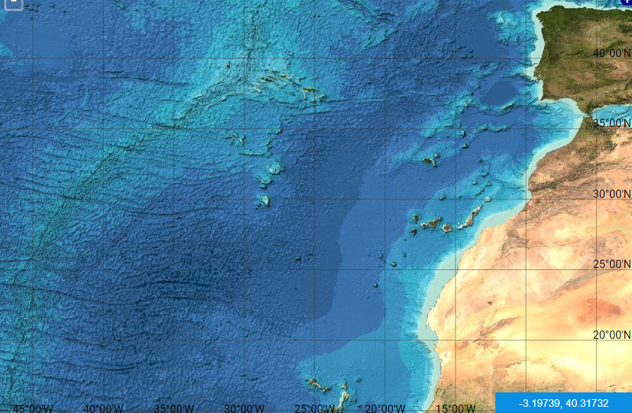
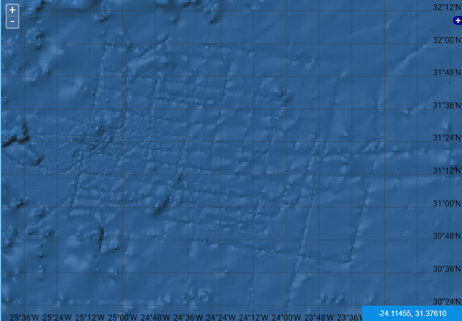
How about now?
Looks like NASA or whoever, forgot to blur some lines.
I always wondered how there are many examples of very straight, almost perfectly straight lines extending for such vast distances under the oceans....
originally posted by: peter vlar
a reply to: schuyler
Sure, aside from the alleged impact event being dated to 12,900 BCE +/- so the timeline is still off a couple of thousand years. And the fact that Plato mentions Athens fighting Atlantis and we KNOW that Athens didn’t exist roughly the same time as Gobekli Tepe. Hancock weaves in interesting story. It’s only when one actually reviews his citations that they find his work is much less fact and far more personal interpretation due to confirmation bias and a need to keep a consistent message despite often moving the goal posts for his loyal readers.
Actually, the impact is said to have happened 11,800 BC or there a bouts, which puts it in the ballpark. Certainly Hancock flits about on his dates and hypotheses. If you've read all his books you can see where his ideas change with each one. He also interweaves his political and religious agenda into his writing, which, to me, is quite frustrating. So yes, he has to be taken with a grain of salt.
However, citing the "Atlantis fought Athens" idea as proof Plato is wrong misses the overall point. It's an embellishment. In the same manner Noah, if he existed at all, certainly did not build an ark to carry every single species in a flood that covered the entire Earth. And it had nothing to do with God causing the flood because men were evil.
But there was a Flood. And the sea level rose 400 feet at the Younger Dryas. And there are a whole lot of reports that there are whole cities beneath the water today. There's your previous civilization. Oddly, the scientific community will never admit to "The Flood," but they will readily admit to the fact that the sea level rose 400 feet.
The point here is that if you are looking for Atlantis in the middle of the Atlantic Ocean, you are being as literal as Plato saying Athens fought Atlantis. In other words, you're looking in the wrong place.
edit on 5/23/2019 by schuyler because: (no reason given)
a reply to: StallionDuck
There was that whole scandal over Google Maps were the earlier version's had a lot more detail on features such as the Atlantic grid in which later versions obscured almost entirely or else processed away the image data in some cases by using a different digital compression which hid the detail's.
As you can see on this newspaper article the grid is still visible but has been made less distinct.
www.dailymail.co.uk...
And it is actually far from alone there are other grid like pattern's around the world under the ocean but non as large as that one and of course they have likely been obscured as well.
Some of this may be purely coincidental as new compression algorithm may be responsible for the loss of data in the visual representation of the sea bed and so there may be no conspiracy at work in this case but it is infuriating and it does make some of these features less distinct - but perhaps more accurate.
Sometime's government's and private entity's may ask Google to remove there property from the map's for reason's which bewilder me because if it's on Google any enemy's they may have will already have better images than those used in Google earth - but of course they sometime's like to hide what they are doing from there own people and private entity's sometime's like there privacy which is fair enough in that final matter.
It is actually a very old art studying the earth from the air and while relatively speaking only a few archaeologists are today using satellite imagery to find sites on land they have for decades at least used crop mark's to detect buried features on a much larger scale.
But using satellite imagery to identify under water ruin's run's into several obvious problem's, usually the resolution is low, the public in many cases has access to higher resolution map's of the moon and mars than they do of the ocean despite such map's actually existing - just not in the public domain.
Water is opaque after a certain depth to almost all wavelength's meaning that only some earth orbiting satellites have or have had the necessary equipment to scan the ocean bottom in any detail though as a matter of course especially during the cold war both NATO (US and Britain for the most part) and the USSR (Specifically Russia) have far more high resolution topographical maps some maybe down to foot scale or below of the ocean bottom, this was necessary for cold war submarine tactic's and in one story the Russian supposedly photographed features around a deep sea mount that showed carved step's partially overflown with ancient lava in the Atlantic though the author of that book as far as I remember never provided an image to prove his assertion.
You will probably find that tale reprinted somewhere on this site.
Here are a few more to wet the appetite for more.
www.beforeus.com...
edit on 23-5-2019 by LABTECH767 because: (no reason given)
a reply to: schuylerYou and I are in the same book, paragraph. The pages change from time to time
My research indicates the flood actually did happen. The problem is how it was effected, and the mechanics of it. Its not all of the scientific community that fight the idea, only a small portion, at the top. There is circumstantial evidence as to how it was pulled off but we are incapable of understanding the science behind it. Oh, its all very simple, but on a scale too eminence to comprehend in one sitting. There are many eye witness accounts of what it looked like just before, and after the flood began. The accounts confirm what happened. The physical evidence supports it.
I can't give you enough stars!
However, citing the "Atlantis fought Athens" idea as proof Plato is wrong misses the overall point. It's an embellishment. In the same manner Noah, if he existed at all, certainly did not build an ark to carry every single species in a flood that covered the entire Earth. And it had nothing to do with God causing the flood because men were evil.
My research indicates the flood actually did happen. The problem is how it was effected, and the mechanics of it. Its not all of the scientific community that fight the idea, only a small portion, at the top. There is circumstantial evidence as to how it was pulled off but we are incapable of understanding the science behind it. Oh, its all very simple, but on a scale too eminence to comprehend in one sitting. There are many eye witness accounts of what it looked like just before, and after the flood began. The accounts confirm what happened. The physical evidence supports it.
You are correct. Very correct. From what I have been able to put together we are systematically misdirected from the true history, and science. If you want to find those ancient settlements, cities, its true, look in the Atlantic, but not the center. On google earth the zones that should be searched are represented in lite blue, before the dark blue of the deep oceans. But don't stop at the Atlantic, search the entire globe. The Hindus of India have already found their ancient lost city in that zone.
The point here is that if you are looking for Atlantis in the middle of the Atlantic Ocean, you are being as literal as Plato saying Athens fought Atlantis. In other words, you're looking in the wrong place.
True again. It had far more to do with bloodlines and family trees. Not all were thrown from the Garden, only those who would not bow down, to the lord god. We, would be made to toil in the soil, if we survived at all. Its a very ugly history.
And it had nothing to do with God causing the flood because men were evil.
I can't give you enough stars!
a reply to: StallionDuck
It wasn't a meteor that caused the flood, but close, really really close
Hold the phone! I think I found the meteor that caused the Great Flood!
It wasn't a meteor that caused the flood, but close, really really close
originally posted by: All Seeing Eye
Its not all of the scientific community that fight the idea, only a small portion, at the top.
At the top? What top?
originally posted by: moebius
www.gebco.net...
That should be detailed enough to show any "lost" islands.
User coordinates for the GEBCO map puts Athanasius Kircher's map at:
-28.06053, 2982644
Flip it upside down (per Egyptian maps with South at the top) and this is what you get:
upload.wikimedia.org...
So how could the ancient Egyptians (aka Atlantians) map it if it was not above water at one time?
originally posted by: StallionDuck
a reply to: StallionDuck
Hold the phone! I think I found the meteor that caused the Great Flood!
You mean Holy Hiawatha!
Larger than Paris. As per what the Egyptian priest told Solon, who told Plato, who told us ~ approximate impact period could be 12,000 years ago ~ causing Atlantis to sink and Noah to float.
phys.org...
astronomy.com...
originally posted by: StallionDuck
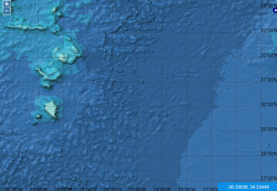
So would you say that the map there on that site is accurate?
I think your third picture shows the scanning grid lines of the machine doing the underwater mapping. At least that was something like Google Maps explanation at the time they removed the lines.
I think your second picture shows Atlantis. The Great Meteor Seamount fits Kircher's redraw of the ancient Egyptian map with over a dozen “coincidences”, like curves and rivers. The main difference being that one of the two smaller islands is offset.
In Kirchers map, we can see where the sea level surrounds the seamount. In the modern mapping we see the base of the seamount where it sits on the bottom of the ocean. The Egyptians sea level and the modern are very close. My guess is that a huge section of land sank, not just an island.
But all those underwater mountains in your second picture would have been above water at the same time most likely. Meaning that this Atlantic island group would have stretched out around 700 miles to the north, much like Portugal. Most likely the Azores would be the island chains highest point.
“Larger than Africa and Asia combined.”
This statement could have come about at least two different ways.
One way would be if Solon saw the same map (or one like it) in Egypt. Remember this; Kircher wrote that the map he copied was brought back from Egypt by the Romans in 30 BC. It is probably still in the Vatican. Solon might have easily thought that the gap between Spain and Africa was supposed to be in scale.
Judging by that, the old maps showing Asia and Africa would easily make Atlantis much larger.
atlantisjavasea.files.wordpress.com...
atlantisjavasea.files.wordpress.com...
www.ancientportsantiques.com...
atlantisjavasea.files.wordpress.com...
atlantisjavasea.files.wordpress.com...
The other way deserves its own post, which follows.
Which saying is correct?
ROME SITS ON SEVEN HILLS.
Or
ROME STRETCHED FROM BRITAIN TO EGYPT.
*
*
*
*
*
*
*
Those of you who guessed BOTH are correct.
And that could be the real answer to “Larger than Africa and Asia combined.”
Atlantis was an EMPIRE.
ROME SITS ON SEVEN HILLS.
Or
ROME STRETCHED FROM BRITAIN TO EGYPT.
*
*
*
*
*
*
*
Those of you who guessed BOTH are correct.
And that could be the real answer to “Larger than Africa and Asia combined.”
Atlantis was an EMPIRE.
new topics
-
President BIDEN's FBI Raided Donald Trump's Florida Home for OBAMA-NORTH KOREA Documents.
Political Conspiracies: 3 hours ago -
Maestro Benedetto
Literature: 5 hours ago -
Is AI Better Than the Hollywood Elite?
Movies: 5 hours ago -
Las Vegas UFO Spotting Teen Traumatized by Demon Creature in Backyard
Aliens and UFOs: 8 hours ago -
2024 Pigeon Forge Rod Run - On the Strip (Video made for you)
Automotive Discussion: 9 hours ago -
Gaza Terrorists Attack US Humanitarian Pier During Construction
Middle East Issues: 9 hours ago -
The functionality of boldening and italics is clunky and no post char limit warning?
ATS Freshman's Forum: 11 hours ago -
Meadows, Giuliani Among 11 Indicted in Arizona in Latest 2020 Election Subversion Case
Mainstream News: 11 hours ago -
Massachusetts Drag Queen Leads Young Kids in Free Palestine Chant
Social Issues and Civil Unrest: 11 hours ago
top topics
-
President BIDEN's FBI Raided Donald Trump's Florida Home for OBAMA-NORTH KOREA Documents.
Political Conspiracies: 3 hours ago, 25 flags -
Krystalnacht on today's most elite Universities?
Social Issues and Civil Unrest: 14 hours ago, 9 flags -
University of Texas Instantly Shuts Down Anti Israel Protests
Education and Media: 17 hours ago, 8 flags -
Weinstein's conviction overturned
Mainstream News: 13 hours ago, 8 flags -
Supreme Court Oral Arguments 4.25.2024 - Are PRESIDENTS IMMUNE From Later Being Prosecuted.
Above Politics: 14 hours ago, 8 flags -
Massachusetts Drag Queen Leads Young Kids in Free Palestine Chant
Social Issues and Civil Unrest: 11 hours ago, 7 flags -
Gaza Terrorists Attack US Humanitarian Pier During Construction
Middle East Issues: 9 hours ago, 7 flags -
Las Vegas UFO Spotting Teen Traumatized by Demon Creature in Backyard
Aliens and UFOs: 8 hours ago, 6 flags -
Meadows, Giuliani Among 11 Indicted in Arizona in Latest 2020 Election Subversion Case
Mainstream News: 11 hours ago, 5 flags -
2024 Pigeon Forge Rod Run - On the Strip (Video made for you)
Automotive Discussion: 9 hours ago, 4 flags
active topics
-
President BIDEN's FBI Raided Donald Trump's Florida Home for OBAMA-NORTH KOREA Documents.
Political Conspiracies • 14 • : WeMustCare -
Hate makes for strange bedfellows
US Political Madness • 47 • : 19Bones79 -
-@TH3WH17ERABB17- -Q- ---TIME TO SHOW THE WORLD--- -Part- --44--
Dissecting Disinformation • 689 • : daskakik -
University of Texas Instantly Shuts Down Anti Israel Protests
Education and Media • 265 • : Astrocometus -
Gaza Terrorists Attack US Humanitarian Pier During Construction
Middle East Issues • 27 • : ToneD -
Reason of the Existence
The Gray Area • 21 • : BingoMcGoof -
Supreme Court Oral Arguments 4.25.2024 - Are PRESIDENTS IMMUNE From Later Being Prosecuted.
Above Politics • 85 • : Sookiechacha -
Chris Christie Wishes Death Upon Trump and Ramaswamy
Politicians & People • 24 • : nugget1 -
New whistleblower Jason Sands speaks on Twitter Spaces last night.
Aliens and UFOs • 63 • : pianopraze -
SETI chief says US has no evidence for alien technology. 'And we never have'
Aliens and UFOs • 74 • : Justoneman