It looks like you're using an Ad Blocker.
Please white-list or disable AboveTopSecret.com in your ad-blocking tool.
Thank you.
Some features of ATS will be disabled while you continue to use an ad-blocker.

Hurricane Michael May Hit Pan Handle
page: 1share:
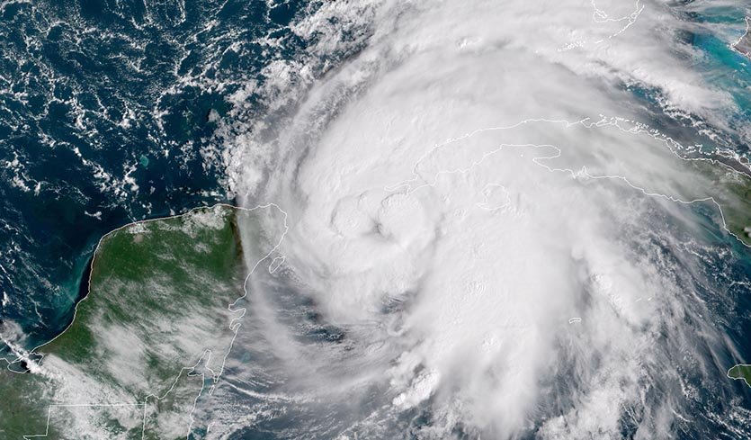
Above: GOES-16 image of Tropical Storm Michael at 10:15 am EDT October 8, 2018. Image credit: NOAA/RAMMB.
Hurricane watches were flying for the Florida Panhandle as rapidly intensifying Hurricane Michael headed northward over the warm waters of the Western Caribbean. Michael is expected to make landfall in the Florida Panhandle on Wednesday as a Category 3 hurricane. Michael is the 13th named storm and 7th hurricane of the 2018 Atlantic hurricane season. It is destined to become the fourth named storm to hit the U.S. this year, and most likely the strongest at landfall. The other three were Subtropical Storm Alberto (May 28 near Pensacola, FL), Category 1 Hurricane Florence (September 14 near Wrightsville Beach, NC), and Tropical Storm Gordon (September 4 near the MS/AL border). On average, the U.S. is hit by three named storms each year, with one of them being a hurricane. Satellite images on Monday morning showed that Michael had improved significantly in organization, with an impressive area of very heavy thunderstorms with cloud tops that were as cold as –80°C (–112°F). Cloud tops this cold can only occur if the updrafts pushing them upwards are very vigorous. Michael was beginning to close off an eye, and low-level spiral banding was improving. Michael was under a moderately high 15 - 20 knots of wind shear, due to strong upper-level winds out of the west from an upper-level trough of low pressure. The storm was embedded in a moist atmosphere with a mid-level relative humidity of 70%, and was over very warm waters of 29.5°C (85°F). These warm waters extended quite deep, and had an extremely high heat content.
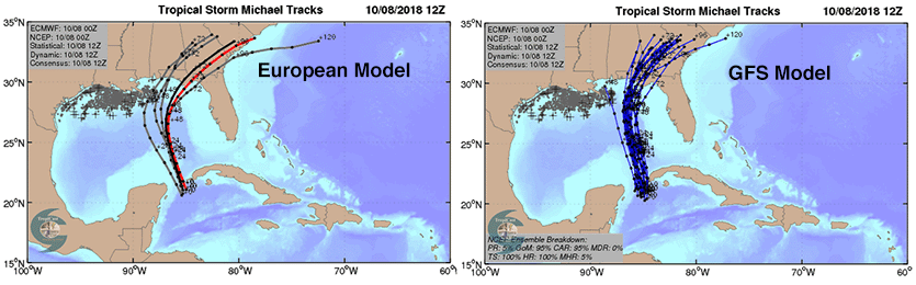
Figure 2. Left: The 0Z Monday, October 8, 2018 track forecast by the operational European model for Michael (red line, adjusted by CFAN using a proprietary technique that accounts for storm movement since the time of the advisory), along with the track of the average of the 50 members of the European model ensemble (heavy black line), and the track forecasts from the “high probability cluster” (grey lines)—the five European model ensemble members that have performed best with Michael thus far. Right: Track forecasts for Michael from the 0Z Monday, October 8, 2018 run of the GFS model. The forecasts agree on a Florida Panhandle landfall, then a curve to the northeast. Image credit: CFAN.
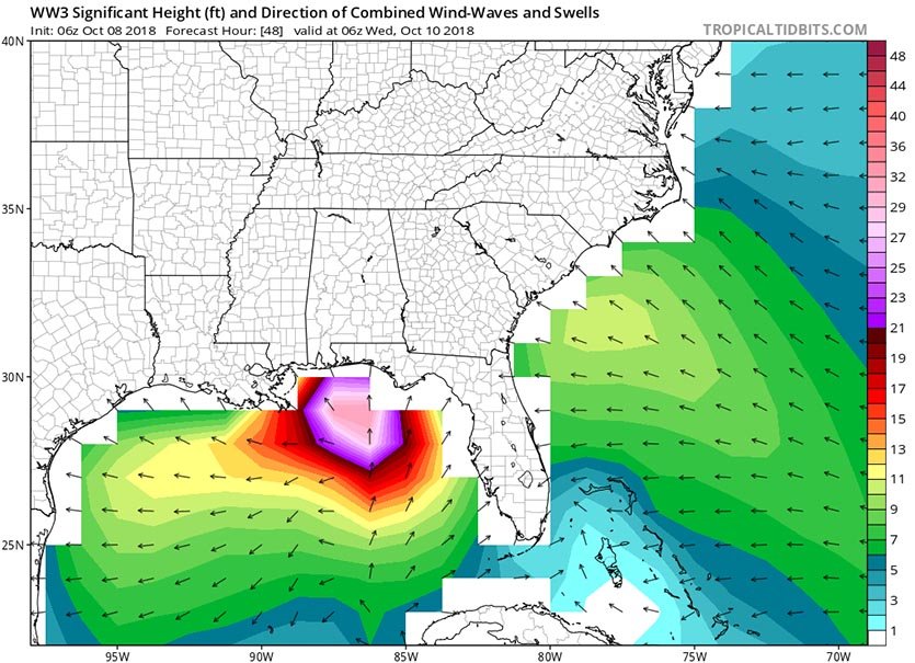
Figure 3. Predicted wave heights for 2 am EDT Wednesday, October 10, 2018, from the 6z (2 am EDT) Monday run of the WaveWatch III model. This model, which uses the GFS model as input, predicts significant waves heights of up to 30 feet in the Gulf of Mexico. Image credit: Levi Cowan, tropicaltidbits.com
A damaging storm surge for the Florida Panhandle A Storm Surge Watch is up for much of Florida's Gulf Coast, from Tampa Bay northwestward to Fort Walton Beach. Persistent onshore winds had already created a storm surge of around 1 – 2 feet along much of the Gulf Coast from Southeast Louisiana to the Florida Panhandle on Monday morning, as seen using our wundermap with the “Storm Surge” layer turned on. There are very shallow waters along the coast where Michael is expected to make landfall, where the continental shelf extends out about 70 – 90 miles from shore. The winds from the storm will thus be able to pile up a large storm surge along the east side of the storm’s center. When this surge rides ashore at landfall, the water may reach heights of 8 - 12 feet in Florida’s Apalachee Bay, between the Florida Panhandle and the southward-jutting Florida Peninsula, since the concave-shaped coast there acts to concentrate storm surge. When Category 3 Hurricane Dennis made landfall in the western Florida Panhandle near Santa Rosa Island in July 10, 2005, it brought a storm surge of 6 - 9 feet to Apalachee Bay, which lay 170 miles east of Dennis’s landfall location. The surge inundated parts of the town of St. Marks and other nearby areas. A storm surge of 4 - 6 ft occurred elsewhere in the Florida Panhandle. High tide is between 12:30 – 1 am on Wednesday and Thursday at Pensacola, FL. There is only one high tide per day in the Gulf, and the difference between high tide and low tide is just over one foot. The high tides in the Gulf this week will not be increased by the fact that the new moon occurs on Monday. This is unlike the situation along the Southeast U.S. coast, where the new moon will bring the king tides—some of the highest tides of the year. Because of the king tides and the onshore flow of air affecting the Southeast U.S. coast from Michael, we are likely to see moderate coastal flooding in Charleston, SC during high tide Monday through Wednesday.
Hopefully this fizzles out. Slightly Unusual for this time of year.
www.wunderground.com...
edit on 8-10-2018 by Sabrechucker because: add
I am on the beach behind Bahama Bob’s at Gulf Shores Alabama. The flying sand and big waves drove my wife and I to take shelter in the restaurant.
We are definitely going to ride this one out. She is planning the hurricane party as we speak.
We are in the Florida keys and currently flooding in our yard , wind and rain .....this storm will pass to the west of us tomorrow and hit the
panhandle as a cat 3 ... This will be ugly for many people there .
edit on 8-10-2018 by Meldionne1 because: (no reason given)
Hope all goes well for you guys. You are already experiencing flooding and high winds?
originally posted by: Sabrechucker
Hope all goes well for you guys. You are already experiencing flooding and high winds?
What area?
I'm not near this thankfully
edit on 8-10-2018 by Sabrechucker because: (no reason given)
MONTGOMERY – Governor Kay Ivey issued a statewide State of Emergency on Monday in anticipation of wide-spread power outages, wind damage and debris produced by high winds and heavy rain associated with Hurricane Michael. Flash flooding and tornadoes are also possible with any hurricane and parts of Alabama have been placed under tropical storm watches or warnings. The State of Emergency went into effect at 3:00 pm CT.
It may not be close enough to bring storms to us here in NW Louisiana. Hopefully the people in the way of this will take necessary precautions and not
try to be heroes.
Wonder if it will help dissipate the algae blooms enough that they are no longer a problem. Other than that, having family in it's path, best of
luck to them and others in in that it won't cause too much flooding and damage.
Regards
Regards
A panhandle strike appears to be inevitable. The question is exactly where and how strong.
Most model guidance brings it ashore near Panama City as a major hurricane...sustained winds at 100kts+.
For the latest information please refer to the National Hurricane Center.
www.nhc.noaa.gov...
Most model guidance brings it ashore near Panama City as a major hurricane...sustained winds at 100kts+.
For the latest information please refer to the National Hurricane Center.
www.nhc.noaa.gov...
Cat 3 now. Pressure is really dropping in it though, yikes. I think we're in the clear here though (Tampa area)...though likely get some of the outer
bands.
As normal, if your on the beach, low lying flood prone areas this could suck, most everybody else will be fine.
But as is the norm now a days, the governor already started the, this is going to be a horrific storm yadda yadda before it had even become a hurricane.
warn the people in the danger areas sure no problem but to whip up a frenzy of fear when there are still so many questions is irresponsible.
But as is the norm now a days, the governor already started the, this is going to be a horrific storm yadda yadda before it had even become a hurricane.
warn the people in the danger areas sure no problem but to whip up a frenzy of fear when there are still so many questions is irresponsible.
a reply to: Sabrechucker
We have been getting rain bands since Sunday night here it Key West. It appears we are done with the rain here but it is still breezy.
We will likely have a major hurricane at landfall. Intensity is always tough to forecast and the gulf waters are quite warm. Further rapid intensification is possible.
a reply to: Sabrechucker
We are fine down here.
It is not uncommon, however the sea surface temperatures are well above average for this time of year which is helping fuel the storm.
The National Hurricane Center is forecasting 125mph winds at land fall.
We are fine down here.
It is not uncommon, however the sea surface temperatures are well above average for this time of year which is helping fuel the storm.
The National Hurricane Center is forecasting 125mph winds at land fall.
new topics
-
Israeli strikes on southern Gaza city of Rafah kill 22, mostly children, as US advances aid package
Middle East Issues: 5 hours ago -
Really Unexplained
Paranormal Studies: 10 hours ago -
The Vaccine Injured
Medical Issues & Conspiracies: 11 hours ago
top topics
-
Zionists of ATS assemble
Political Issues: 17 hours ago, 13 flags -
Leading Surgeon from Al-Shifa Hospital Dies in Israeli Custody
Middle East Issues: 14 hours ago, 8 flags -
The Vaccine Injured
Medical Issues & Conspiracies: 11 hours ago, 4 flags -
Really Unexplained
Paranormal Studies: 10 hours ago, 4 flags -
Israeli strikes on southern Gaza city of Rafah kill 22, mostly children, as US advances aid package
Middle East Issues: 5 hours ago, 4 flags
active topics
-
Zionists of ATS assemble
Political Issues • 124 • : DBCowboy -
Hard evidence of a Royal plot on the US....if only i had proof.
ATS Skunk Works • 96 • : stonerwilliam -
France makes abortion a constitutional right in historic vote
Other Current Events • 295 • : burritocat -
Really Unexplained
Paranormal Studies • 23 • : KnowItAllKnowNothin -
UN Estimates Rebuilding Gaza Will Cost Up To 40 Billion Dollars
Middle East Issues • 103 • : DBCowboy -
Israeli strikes on southern Gaza city of Rafah kill 22, mostly children, as US advances aid package
Middle East Issues • 87 • : Shoshanna -
-@TH3WH17ERABB17- -Q- ---TIME TO SHOW THE WORLD--- -Part- --44--
Dissecting Disinformation • 802 • : nerbot -
The Vaccine Injured
Medical Issues & Conspiracies • 9 • : ARM19688 -
Candidate TRUMP Now Has Crazy Judge JUAN MERCHAN After Him - The Stormy Daniels Hush-Money Case.
Political Conspiracies • 1185 • : Annee -
Lawsuit Seeks to ‘Ban the Jab’ in Florida
Diseases and Pandemics • 37 • : lilzazz