It looks like you're using an Ad Blocker.
Please white-list or disable AboveTopSecret.com in your ad-blocking tool.
Thank you.
Some features of ATS will be disabled while you continue to use an ad-blocker.

Project Faultless and Project Shoal photograhed by drone
page: 18
share:
Project Faultless and Project Shoal are some of the US Department of Energy test sites that are not at the Nevada Test Site.
Project Faultless has been photographed often. It is just down the road from Base Camp along route 6 in Nevada.
The goal of Project Faultless was to do high yield testing further away from Las Vegas because all that shaking was bad for business. As it turned out, the site for the test was anything but "faultless." The DOE abandoned the project, but the USAF keep the staging area know as Base Camp. The CIA likes it too.
With that introduction, here are the photos.
Faultless overview
Faultless directly from above
I don't know much about Project Shoal, so I will just post the links.
shoal 1
Shoal 2
Shoal 3
The photographer is a pro. Here is his Flickr portfolio:
www.flickr.com...
edit on 26-3-2017 by gariac because: (no reason given)
a reply to: gariac
Awesome. That place is 'Hot'. The concrete containment is crumbling after only a few decades.
The liquid pit is disturbing. Radioactive Contamination attached to water molecules evaporate and drift on the wind.
What a waste land.
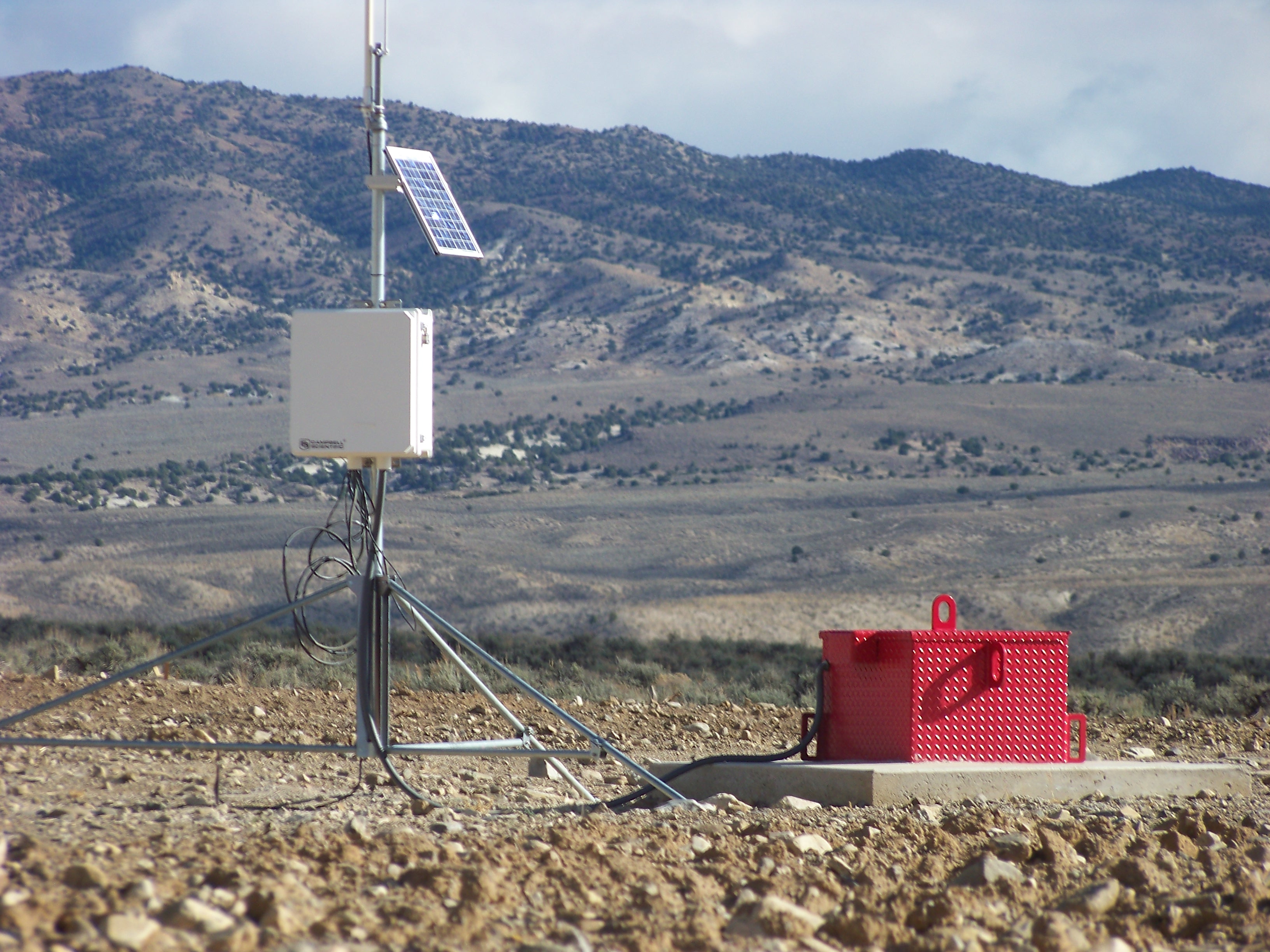
Ongoing monitoring equipment in the red box. A big dosimeter at ground zero...
image
Awesome. That place is 'Hot'. The concrete containment is crumbling after only a few decades.
The liquid pit is disturbing. Radioactive Contamination attached to water molecules evaporate and drift on the wind.
What a waste land.
Ongoing monitoring equipment in the red box. A big dosimeter at ground zero...
image
Apparently the Shoal site was selected due to the local seismicity of the area, so they could compare natural seismic activity to the readings their
nuclear tests produced.
Fascinating history and pics. Thank-you.
en.wikipedia.org...
Peace.
Fascinating history and pics. Thank-you.
en.wikipedia.org...
Peace.
Things like this make people think that drones are okay, and then the next thing you know it will be used for something much worse and currently is.
BTW, I believe before the blast that the concrete was at ground level.
If someone tries to do some drone shots, do it in late afternoon so the low sun angle can emphasize the ripple in the ground due to the blast.
When you are on the ground, you can't sense the scope of the damage. It is like the ground settled in a shock wave.
If someone tries to do some drone shots, do it in late afternoon so the low sun angle can emphasize the ripple in the ground due to the blast.
When you are on the ground, you can't sense the scope of the damage. It is like the ground settled in a shock wave.
originally posted by: intrptr
a reply to: gariac
Awesome. That place is 'Hot'. The concrete containment is crumbling after only a few decades.
The liquid pit is disturbing. Radioactive Contamination attached to water molecules evaporate and drift on the wind.
What a waste land.
Ongoing monitoring equipment in the red box. A big dosimeter at ground zero...
image
I couldn't help myself, I had to look in the big red box:
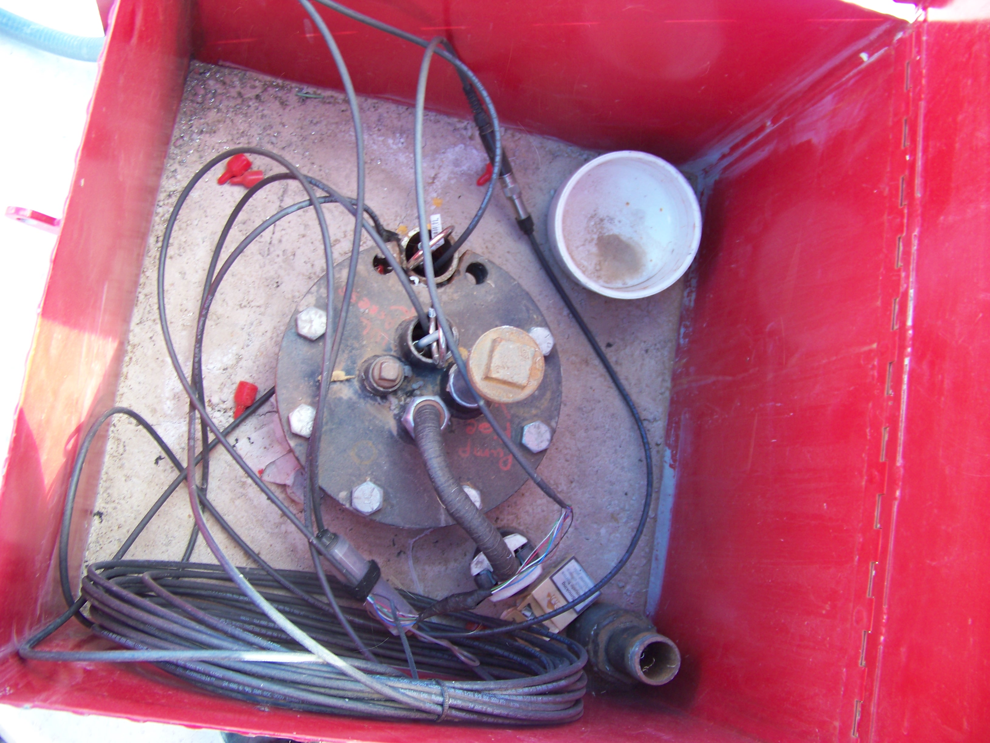
a reply to: FosterVS
And...?
You personally opened pandoras box... You know you've been exposed to whatever contamination comes up thru those open pipes?
Source the photo please.
link to image
And...?
You personally opened pandoras box... You know you've been exposed to whatever contamination comes up thru those open pipes?
Source the photo please.
link to image
edit on 26-3-2017
by intrptr because: link
originally posted by: intrptr
a reply to: FosterVS
And...?
You personally opened pandoras box... You know you've been exposed to whatever contamination comes up thru those open pipes?
Source the photo please.
link to image
Yeah? I heard a little plutonium goes good on corn flakes. Looks like they have put a padlock on since I "opened pandoras box".
Source the photo? Umm, I took it? 2010?
FYI, it was Project Faultless, not Project Shoal.
edit on 26-3-2017 by FosterVS because: (no reason given)
originally posted by: gariac
BTW, I believe before the blast that the concrete was at ground level.
If someone tries to do some drone shots, do it in late afternoon so the low sun angle can emphasize the ripple in the ground due to the blast.
When you are on the ground, you can't sense the scope of the damage. It is like the ground settled in a shock wave.
If you are on the ground, and know the history of what happened, you can see the whole area has dropped a LOT of feet. That ridge in this picture didn't exist before the shot.
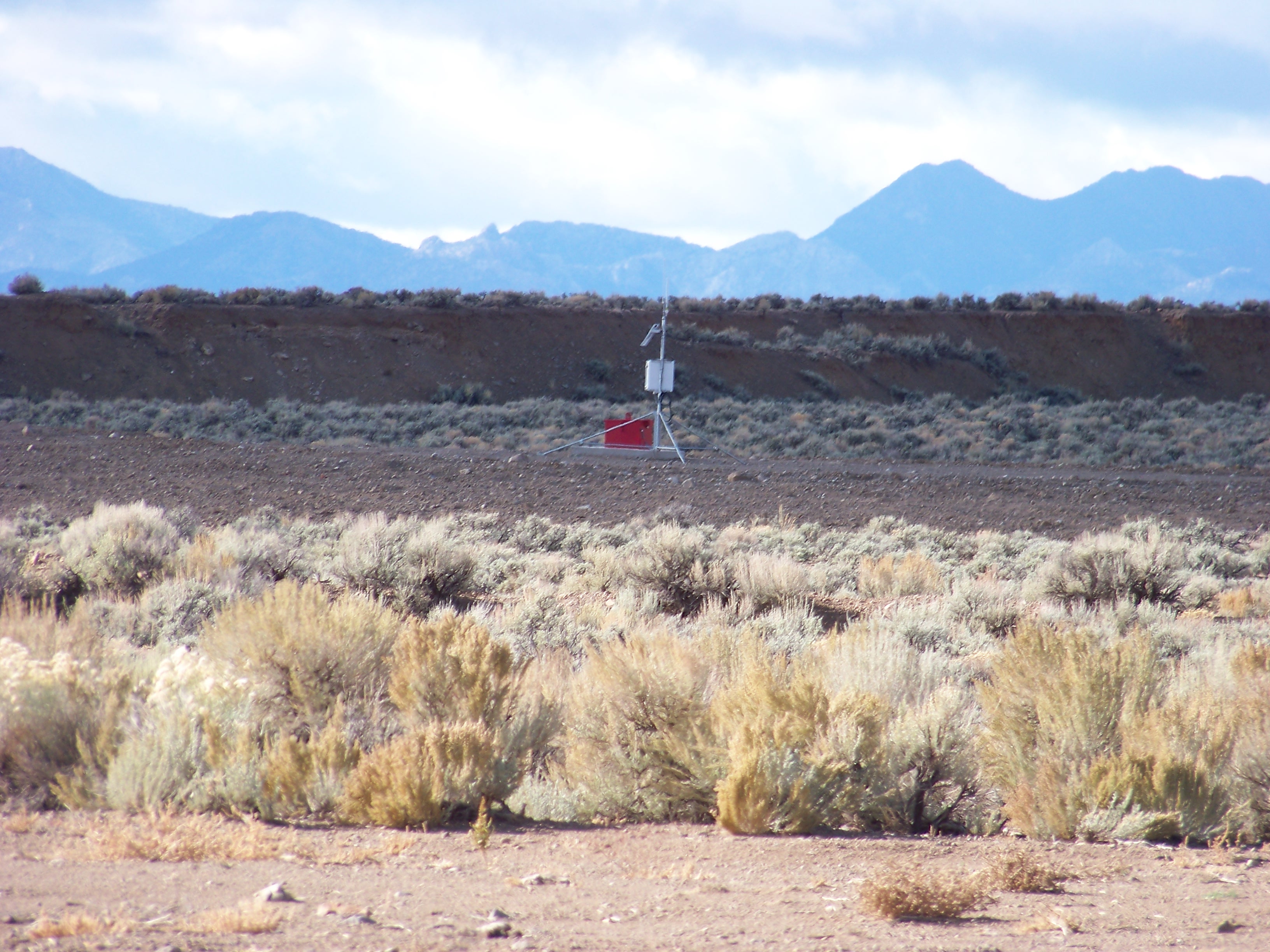
Red Box of Doom
edit on 26-3-2017 by FosterVS because: (no reason given)
a reply to: FosterVS
That was going to be my next question, where'd you get the key?
The don't paint steel reinforced diamond plate lock boxes fire engine red and mount them on a thick cement pad unless they are covering something dangerous up.
Namely the deep sensors there that monitor seismicity and radiation.
Looks like they have put a padlock on since I "opened pandoras box".
That was going to be my next question, where'd you get the key?
The don't paint steel reinforced diamond plate lock boxes fire engine red and mount them on a thick cement pad unless they are covering something dangerous up.
Namely the deep sensors there that monitor seismicity and radiation.
originally posted by: intrptr
a reply to: FosterVS
Looks like they have put a padlock on since I "opened pandoras box".
That was going to be my next question, where'd you get the key?
The don't paint steel reinforced diamond plate lock boxes fire engine red and mount them on a thick cement pad unless they are covering something dangerous up.
Namely the deep sensors there that monitor seismicity and radiation.
Oh I'm sure lots of things get painted red or mounted on cement pads that have nothing to do with radioactivity.
However in this case you could be right, although the cement pad ensures the box doesn't go anywhere, and red kinda makes it stand out in case someone misses seeing it.
edit on 26-3-2017 by FosterVS because: (no reason given)
a reply to: FosterVS
Except on, say.... nuclear test site monitoring stations? I see they added a remote feature powered by solar cell. When did you take that photo?
Oh I'm sure lots of things get painted red or mounted on cement pads that have nothing to do with radioactivity.
Except on, say.... nuclear test site monitoring stations? I see they added a remote feature powered by solar cell. When did you take that photo?
I updated my Project Faultless page.
www.lazygranch.com...
The video I link to on youtube is a constant battle of takedowns. However I found an old one with some video of the blast and embedded it at the top.
www.lazygranch.com...
The video I link to on youtube is a constant battle of takedowns. However I found an old one with some video of the blast and embedded it at the top.
new topics
-
Big Storms
Fragile Earth: 15 minutes ago -
Where should Trump hold his next rally
2024 Elections: 2 hours ago -
Shocking Number of Voters are Open to Committing Election Fraud
US Political Madness: 3 hours ago -
Gov Kristi Noem Shot and Killed "Less Than Worthless Dog" and a 'Smelly Goat
2024 Elections: 4 hours ago -
Falkville Robot-Man
Aliens and UFOs: 4 hours ago -
James O’Keefe: I have evidence that exposes the CIA, and it’s on camera.
Whistle Blowers and Leaked Documents: 5 hours ago -
Australian PM says the quiet part out loud - "free speech is a threat to democratic dicourse"...?!
New World Order: 6 hours ago -
Ireland VS Globalists
Social Issues and Civil Unrest: 6 hours ago -
Biden "Happy To Debate Trump"
2024 Elections: 7 hours ago -
RAAF airbase in Roswell, New Mexico is on fire
Aliens and UFOs: 7 hours ago
top topics
-
A Warning to America: 25 Ways the US is Being Destroyed
New World Order: 17 hours ago, 21 flags -
Blast from the past: ATS Review Podcast, 2006: With All Three Amigos
Member PODcasts: 9 hours ago, 13 flags -
James O’Keefe: I have evidence that exposes the CIA, and it’s on camera.
Whistle Blowers and Leaked Documents: 5 hours ago, 12 flags -
Australian PM says the quiet part out loud - "free speech is a threat to democratic dicourse"...?!
New World Order: 6 hours ago, 12 flags -
Biden "Happy To Debate Trump"
2024 Elections: 7 hours ago, 11 flags -
Mike Pinder The Moody Blues R.I.P.
Music: 9 hours ago, 8 flags -
What is the white pill?
Philosophy and Metaphysics: 8 hours ago, 6 flags -
Shocking Number of Voters are Open to Committing Election Fraud
US Political Madness: 3 hours ago, 5 flags -
Ireland VS Globalists
Social Issues and Civil Unrest: 6 hours ago, 5 flags -
RAAF airbase in Roswell, New Mexico is on fire
Aliens and UFOs: 7 hours ago, 5 flags
active topics
-
Big Storms
Fragile Earth • 2 • : xuenchen -
Massachusetts Drag Queen Leads Young Kids in Free Palestine Chant
Social Issues and Civil Unrest • 21 • : ToneD -
Biden "Happy To Debate Trump"
2024 Elections • 49 • : TheMisguidedAngel -
Candidate TRUMP Now Has Crazy Judge JUAN MERCHAN After Him - The Stormy Daniels Hush-Money Case.
Political Conspiracies • 816 • : xuenchen -
Where should Trump hold his next rally
2024 Elections • 13 • : Edumakated -
Shocking Number of Voters are Open to Committing Election Fraud
US Political Madness • 6 • : marg6043 -
University of Texas Instantly Shuts Down Anti Israel Protests
Education and Media • 312 • : marg6043 -
Gov Kristi Noem Shot and Killed "Less Than Worthless Dog" and a 'Smelly Goat
2024 Elections • 30 • : TheMisguidedAngel -
President BIDEN's FBI Raided Donald Trump's Florida Home for OBAMA-NORTH KOREA Documents.
Political Conspiracies • 36 • : BingoMcGoof -
ALERT - U.S. President JOE BIDEN Examined and Found NOT OF SOUND MIND.
2024 Elections • 64 • : WeMustCare
8