It looks like you're using an Ad Blocker.
Please white-list or disable AboveTopSecret.com in your ad-blocking tool.
Thank you.
Some features of ATS will be disabled while you continue to use an ad-blocker.

I May Have Detected Volcanic Tremor at LA PALMA- not El Hierro- Yes- at Mr. Mega Tsunami!
page: 5share:
Originally posted by lacrimoniousfinale
Snip
Next time I'm in the bath, I'll take a brick and not my usual rubber duck, and conduct a few experiments.
Take two.
Balance one atop the other off center so that it takes the merest push to topple it off of the other brick. try nd make sure the water is as deep as possible and watch what the water does against the side of the tub in the direction the brick falls.
edit on 26-3-2013 by jadedANDcynical
because: Typos
For extra credit you can add some dye to the water and videotape the result to demonstrate how the currents flow.
edit on 26-3-2013 by
jadedANDcynical because: Extra credit assignment lol
edit on 26-3-2013 by jadedANDcynical because: Dye not eye....I'm gonna quit now.
Not sure if this has been posted by anyone else but this is in the MSN now.
Source

Source
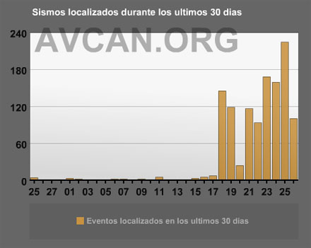
inShare Earthquakes, Inflation Suggest New Magma Intruding Under El Hierro Well, now it seems that magma is clearly on the move underneath the island once again. AVCAN has been tracking the seismicity and there have been hundreds to thousands of small earthquakes under El Hierro at depth of 10-20 km since March 18 (see right). However, the most interesting news is the sharp inflation the island has been experiencing, with ~10 cm of uplift in the westernmost part of El Hierro in only the last 10 days, near the focus of the earthquakes. This location of uplift and seismicity is very different than the 2010-11 activity (see above), which was centered to the south of the island. There has been no signs of undersea eruptive activity so far, according to scientists on the Ramón Margalef, a research vessel in the waters off of El Hierro.
edit on 26-3-2013 by rigel4 because: (no reason given)
reply to post by TrueAmerican
How True "True" ... professionals have a "group think" about them that they dismiss a novices information .....
it is just the nature of things that we are dismissed because we aren't in the group .....
I get that all the time when I try to discuss the economy with professionals and economists ...... the fact is often they can not see the trees in the forest .....
I've gone back to see what El Heirro looked like during the eruption in 2011. What I see is a steady a series of very narrow band signals. That seems
to match this definition.
Looking at the spectrum from La Palma on March 3 and forward, I see a very wideband signal so it does not seem, to my eye, to represent a harmonic tremor. But another feature of volcanic seismic activity is described as this:
www.springerreference.com...
While there is a broadband "burst" on March 3rd which does extend to higher frequencies, that seems to be about it. After the initial signal at about 17:00 nothing else seems to happen. From what I can gather, the spasmodic bursts which result from volcanic activity tend to go on for a while and should also display narrow band spectrum(s).
Is it common for volcanic tremors to occur in the absence of stronger activity? It seems that the El Heirro eruption was preceded by a period of quakes before the harmonic activity began.
I also understand that seismometers are subject to various noise effects. Things like wind and waves. Any chance that something transient like that is showing up?
www.ceri.memphis.edu...
There are some other things I notice about the spectrum from La Palma. On the 3rd, at 14:00 there is a sudden full bandwith increase in the signal strength. This is repeated at 17:00. Going back to the 2nd a similar thing happens at 05:00. This sort of thing, with most forms of instrumentation, indicates something going on with the equipment rather than being true readings.
Harmonic tremor is defined as seismicity consisting of a continuous low frequency, often single frequency, sine wave with smoothly varying amplitude, and is caused by complex interactions between magma (see Magma), exsolved gases, and bedrock at volcanoes (McNutt, 2000).
Looking at the spectrum from La Palma on March 3 and forward, I see a very wideband signal so it does not seem, to my eye, to represent a harmonic tremor. But another feature of volcanic seismic activity is described as this:
However, harmonic bursts have a relatively uniform signal, whereas spasmodic bursts have a higher frequency, pulsating, irregular signal.
www.springerreference.com...
While there is a broadband "burst" on March 3rd which does extend to higher frequencies, that seems to be about it. After the initial signal at about 17:00 nothing else seems to happen. From what I can gather, the spasmodic bursts which result from volcanic activity tend to go on for a while and should also display narrow band spectrum(s).
Is it common for volcanic tremors to occur in the absence of stronger activity? It seems that the El Heirro eruption was preceded by a period of quakes before the harmonic activity began.
I also understand that seismometers are subject to various noise effects. Things like wind and waves. Any chance that something transient like that is showing up?
www.ceri.memphis.edu...
There are some other things I notice about the spectrum from La Palma. On the 3rd, at 14:00 there is a sudden full bandwith increase in the signal strength. This is repeated at 17:00. Going back to the 2nd a similar thing happens at 05:00. This sort of thing, with most forms of instrumentation, indicates something going on with the equipment rather than being true readings.
edit on 3/26/2013 by Phage because: (no reason given)
Interesting. I was just reviewing the original Ward/Day pdf of the speculated mega tsunami, and came across this:
www.es.ucsc.edu...
Volcanoes vary so widely in eruption characteristics, that this could be one of those that doesn't have a lot of seismic activity associated with eruptions. It might just have tremor... then kapow.
Of course it could be that it was not monitored to the extent it is now, and there WAS seismicity, it's just that there are no RECORDS of it.
If it weren't for the fact that there have been several flank failures on this island, I wouldn't be too worried about it either.
So after 5 pages, it seems no one is contesting the OP's premise, that these particular events are tremor at or near La Palma. I figured by now someone like John Vidale or PuterMan would be in here to destroy me. Well? Where's the beef?
You checked on world earthquakes, to see if any of these events might be teleseisms. But teleseisms don't last for hours, now do they. Nope. Maybe on a monster quake, ok...but seen any of those on the dates of the events in question?
You checked to see if it might be different types of high gain vs. low gain instruments, but nope, sorry, they are both short period stations. Oops, can't destroy me there either. Well darnit. I guess since TA might have a point, I am just not going to comment at all.
See what I mean about arrogance?
Even Phage just got his own piece of hatchet from westcoast, who was pretty much dead on. Thanks, sweetie. I wouldn't expect Mr. Spaceman there to know the ins and outs of volcano monitoring. But the guy's a genius with space topics.
Tremor is not counted as earthquakes, is the moral of that story. And it is why once a quake is detected anywhere near a volcano in the US, at a shallow enough depth, it is left up to the volcano monitoring agency to assess it and report it. For example, up in Alaska, the USGS/NEIC will report on deep quakes close to Redoubt/ Spurr/Iliamna and many others, but if they are close to a volcano and shallow, forget it. Let the AVO handle that.
And at Yellowstone? Ha, not until the UoU assesses it and reports it. Although that may have changed recently. Information I have from those snooty scientists is that they are turning it over to the NEIC. In fact, there have been a lot of changes recently to the organization of volcano monitoring agencies, so it is all getting blurred here in the US. Who is authoritative, who handles what... I just can't keep up with it anymore.
If that is indeed tremor at one of the volcanoes at La Palma that I have spotted here, one telling differentiation is the frequency response of that tremor vs. the tremor at El Hierro. The tremor at El Hierro clearly resides in a higher frequency range- but still in the known range of tremor, which is all the way from 0.6 to 9 Hz or so. Pinatubo's tremor range, for example, was 0-2 Hz hot.
And Harmonic Tremor is just one type of tremor. It doesn't occur at all volcanoes prior to eruption- because it takes a specific kind of cavity resonance to create the harmonics. So whether there is or there isn't HT, really has no bearing on whether a volcano is going to erupt or not- even if there has been HT in a previous eruption sequence at the same volcano.
As to all the debate about the possibility of that flank collapsing, I have read an awful lot. My opinion at this point is that it could go either way, because people on both sides of the argument have made good points. So I remain open to the possibility. And because of that, yes, if one of the volcanoes on La Palma decides to blow, I AM concerned.
No records exist of seismic activity associated with the 1949 eruption, or the subsequent 1971 eruption at the island's southern tip. No other tectonic earthquakes of consequence have struck under La Palma in the last three decades either.
www.es.ucsc.edu...
Volcanoes vary so widely in eruption characteristics, that this could be one of those that doesn't have a lot of seismic activity associated with eruptions. It might just have tremor... then kapow.
Of course it could be that it was not monitored to the extent it is now, and there WAS seismicity, it's just that there are no RECORDS of it.
If it weren't for the fact that there have been several flank failures on this island, I wouldn't be too worried about it either.
So after 5 pages, it seems no one is contesting the OP's premise, that these particular events are tremor at or near La Palma. I figured by now someone like John Vidale or PuterMan would be in here to destroy me. Well? Where's the beef?
You checked on world earthquakes, to see if any of these events might be teleseisms. But teleseisms don't last for hours, now do they. Nope. Maybe on a monster quake, ok...but seen any of those on the dates of the events in question?
You checked to see if it might be different types of high gain vs. low gain instruments, but nope, sorry, they are both short period stations. Oops, can't destroy me there either. Well darnit. I guess since TA might have a point, I am just not going to comment at all.
See what I mean about arrogance?
Even Phage just got his own piece of hatchet from westcoast, who was pretty much dead on. Thanks, sweetie. I wouldn't expect Mr. Spaceman there to know the ins and outs of volcano monitoring. But the guy's a genius with space topics.
Tremor is not counted as earthquakes, is the moral of that story. And it is why once a quake is detected anywhere near a volcano in the US, at a shallow enough depth, it is left up to the volcano monitoring agency to assess it and report it. For example, up in Alaska, the USGS/NEIC will report on deep quakes close to Redoubt/ Spurr/Iliamna and many others, but if they are close to a volcano and shallow, forget it. Let the AVO handle that.
And at Yellowstone? Ha, not until the UoU assesses it and reports it. Although that may have changed recently. Information I have from those snooty scientists is that they are turning it over to the NEIC. In fact, there have been a lot of changes recently to the organization of volcano monitoring agencies, so it is all getting blurred here in the US. Who is authoritative, who handles what... I just can't keep up with it anymore.
If that is indeed tremor at one of the volcanoes at La Palma that I have spotted here, one telling differentiation is the frequency response of that tremor vs. the tremor at El Hierro. The tremor at El Hierro clearly resides in a higher frequency range- but still in the known range of tremor, which is all the way from 0.6 to 9 Hz or so. Pinatubo's tremor range, for example, was 0-2 Hz hot.
And Harmonic Tremor is just one type of tremor. It doesn't occur at all volcanoes prior to eruption- because it takes a specific kind of cavity resonance to create the harmonics. So whether there is or there isn't HT, really has no bearing on whether a volcano is going to erupt or not- even if there has been HT in a previous eruption sequence at the same volcano.
As to all the debate about the possibility of that flank collapsing, I have read an awful lot. My opinion at this point is that it could go either way, because people on both sides of the argument have made good points. So I remain open to the possibility. And because of that, yes, if one of the volcanoes on La Palma decides to blow, I AM concerned.
Concerning the tsunami threat, experts are often wrong, and it all depends on how the slide occurs, if it occurs. Computer models behave just the way
they are programed, nothing more. If there is a slow gradual collpase, it will likely dissipate, although it is still better to be safe than sorry,
so you still evacuate. However if it goes during an explosive eruption and we get a flank collpase like Mount St. Helens, only under water, we are
going to have a problem.
Those graphs look interesting - low frequency vs. time. I wish I could really understand what they mean. I can only guess that they indicate something
like a boiler system going critical, with hot lava, water and steam travelling through rock at increasing speeds and pressures.
reply to post by TrueAmerican
Just throwing this out, TA. It's a long shot...
Any chance that what you are seeing is from cruise ships coming into and/or out of port? The timing of the graphics you provided looks like early morning and mid-afternoon activity start times (in order of posting, approximately 15:40, 13:15, 05:35, 05:50, and 16:45 utc=local time).
ETA: Thank you for the link in the OP.
edit on 3/26/2013 by Olivine because: add
Originally posted by Olivine
reply to post by TrueAmerican
Just throwing this out, TA. It's a long shot...
Any chance that what you are seeing is from cruise ships coming into and/or out of port? The timing of the graphics you provided looks like early morning and mid-afternoon activity start times (in order of posting, approximately 15:40, 13:15, 05:35, 05:50, and 16:45 utc=local time).
Now that's an interesting suggestion. But...
28.5567, -17.8062
Those are the coordinates to the La Palma seismic station. It's about 2 km from the coast. And a spot check glance at the coastline on that side shows no ports whatsoever. That coast is not conducive to ports, seeing as the volcanic rock faces are real high next to the water. The station is pretty well isolated, except for one road. And I have yet to see a single vehicle type signature in all those spectrograms I saw doing the research for this thread. Of course, I wasn't exactly looking for them.
Slam those into google maps and check it yourself.
So I am going to have to conclude no, can't be ships. And I plugged your thread in the OP, btw. We just happened to post about Hierro and La Palma on the same day. Sorry bout that. Wasn't trying to steal your thunder- that's a good thread.
Also, I am just now realizing that a lot of people do not understand spectrograms, whereas I look at them day in and day out. For those of you at the sole mercy of sheer opinion, whether it be mine or another's, I did say "MAY have detected" in the thread title. Because honestly, I am not sure. But until someone comes along to show that these events can't be tremor, it's looking an awful lot like tremor to me. But it might be high wind noise, as there are some trees in the area.
Originally posted by TrueAmerican
Slam those into google maps and check it yourself.
You know I already had, just to make sure there was a port nearby. The port looks to be some 20 kms distant, and the shipping routes don't swing around to the south (at least the ones shown)
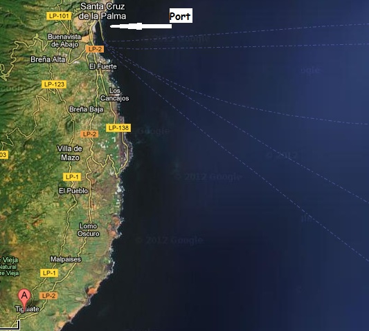
Just taking a shot, because I do know those big ships can put out low-frequency vibrations. And the Canaries are a cruise ship hotspot.
I'm curious to see what develops--I'll be watching this thread.
Thanks again for the shout out.
edit on 3/26/2013 by Olivine because: (no reason given)
edit on 3/26/2013 by Olivine
because: (no reason given)
reply to post by Olivine
lol... I meant right at the coast near the station, not 20 kms away!
But even in that case, I would think that because the ships are decoupled from the ground via the water, that it would be not likely that the station would pick them up at that distance. Also, I think ship frequencies aren't quite THAT low. I dunno, willing to entertain further the idea if perhaps you were to produce a spectrogram of a ship from a seismic station on land, about 20 kms away, say from a port in CA or something- that looked similar to what we are seeing here. School me- ready to learn.
I have been hunting high and low and just can't find the info. When I was studying Geography at university, La Palma was an area we looked at for
subterranean landslips. Now given senility has probably set in, but I remember that the last landslip at La Palma preceeded a volcanic eruption not as
a result of.
I have tried every which way I can to find info and needless to say all I find is link after link on all the speculation should another landslip occur.
All I am saying is that could what you have picked up on is a landlip happening and not volcanic activity?
Rainbows
Jane
I have tried every which way I can to find info and needless to say all I find is link after link on all the speculation should another landslip occur.
All I am saying is that could what you have picked up on is a landlip happening and not volcanic activity?
Rainbows
Jane
Wow...That was trippy...Dude, scroll down the OP really quickly and it almost becomes a definable pattern.Starred for provocative and in depth
comment.... and the sweet scroll experience.
reply to post by TrueAmerican
Did you mean West Coast?
causing the massive tsunami to hit the east coast of the USA
Did you mean West Coast?
The following is my opinion as a member participating in this discussion.
Originally posted by TrueAmerican
Also, I think ship frequencies aren't quite THAT low. I dunno, willing to entertain further the idea if perhaps you were to produce a spectrogram of a ship from a seismic station on land, about 20 kms away, say from a port in CA or something- that looked similar to what we are seeing here. School me- ready to learn.
Does this help?
As an ATS Staff Member, I will not moderate in threads such as this where I have participated as a member.
reply to post by Staroth
Uhh, La Palma is to the east to the US.. You are thinking of the situation where a large earthquake on the west coast would inundate the.. west coast.
Uhh, La Palma is to the east to the US.. You are thinking of the situation where a large earthquake on the west coast would inundate the.. west coast.
Originally posted by Staroth
reply to post by TrueAmerican
causing the massive tsunami to hit the east coast of the USA
Did you mean West Coast?
The West Coast of Africa. I don't think it would be quite big enough to reach the West Coast of the US considering the amount of land it would have to cross over to get there.
new topics
-
Ireland VS Globalists
Social Issues and Civil Unrest: 29 minutes ago -
Biden "Happy To Debate Trump"
Mainstream News: 1 hours ago -
RAAF airbase in Roswell, New Mexico is on fire
Aliens and UFOs: 1 hours ago -
What is the white pill?
Philosophy and Metaphysics: 2 hours ago -
Mike Pinder The Moody Blues R.I.P.
Music: 3 hours ago -
Putin, Russia and the Great Architects of the Universe
ATS Skunk Works: 6 hours ago -
A Warning to America: 25 Ways the US is Being Destroyed
New World Order: 10 hours ago
top topics
-
President BIDEN's FBI Raided Donald Trump's Florida Home for OBAMA-NORTH KOREA Documents.
Political Conspiracies: 16 hours ago, 35 flags -
A Warning to America: 25 Ways the US is Being Destroyed
New World Order: 10 hours ago, 18 flags -
Mike Pinder The Moody Blues R.I.P.
Music: 3 hours ago, 7 flags -
What is the white pill?
Philosophy and Metaphysics: 2 hours ago, 5 flags -
Biden "Happy To Debate Trump"
Mainstream News: 1 hours ago, 5 flags -
RAAF airbase in Roswell, New Mexico is on fire
Aliens and UFOs: 1 hours ago, 4 flags -
Putin, Russia and the Great Architects of the Universe
ATS Skunk Works: 6 hours ago, 2 flags -
Ireland VS Globalists
Social Issues and Civil Unrest: 29 minutes ago, 2 flags
active topics
-
Biden "Happy To Debate Trump"
Mainstream News • 17 • : RazorV66 -
Putin, Russia and the Great Architects of the Universe
ATS Skunk Works • 22 • : SchrodingersRat -
Candidate TRUMP Now Has Crazy Judge JUAN MERCHAN After Him - The Stormy Daniels Hush-Money Case.
Political Conspiracies • 793 • : matafuchs -
University of Texas Instantly Shuts Down Anti Israel Protests
Education and Media • 279 • : cherokeetroy -
Is AI Better Than the Hollywood Elite?
Movies • 22 • : 5thHead -
King Charles 111 Diagnosed with Cancer
Mainstream News • 324 • : Oldcarpy2 -
Ireland VS Globalists
Social Issues and Civil Unrest • 2 • : TimBurr -
President Biden is Angry at A.G. Merrick Garland for Not Being Loyal to the Biden Family.
Above Politics • 20 • : WeMustCare -
RAAF airbase in Roswell, New Mexico is on fire
Aliens and UFOs • 4 • : gortex -
New whistleblower Jason Sands speaks on Twitter Spaces last night.
Aliens and UFOs • 75 • : baablacksheep1