It looks like you're using an Ad Blocker.
Please white-list or disable AboveTopSecret.com in your ad-blocking tool.
Thank you.
Some features of ATS will be disabled while you continue to use an ad-blocker.

I May Have Detected Volcanic Tremor at LA PALMA- not El Hierro- Yes- at Mr. Mega Tsunami!
page: 6share:
reply to post by TrueAmerican
True detective work, there. It looks like the power is in fact increasing. Based on your time scale.
From your charts you appear to have monitored a brief window of activity that appears seismic associated with volcanic activity. The first window was last year from 10-28 thru 11-1. Each chart showed a spike and then a bit later some further activity. Thats the like volcanic part. Earthquakes trigger and then steadily wind down. The charts you brought show this gap between the initial spike and the reduced rumbling that tapers off later.
If a collapse of a roof in a magma chamber occurred, it might look like that. Then the other activity later is the new chamber welling up with lava as it slowly makes its way to the surface.
the 3-3-2013 chart shows another spike simultaneous with the trailing activity.
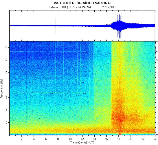
If these are all coming from deep in the crater and they get larger and closer to the surface, it could precipitate the East Coasts worst nightmare.
I saw the show about the collapse of the crater rim and the resulting tsunami that could threaten the entire eastern seaboard of the United states.
Lets hope that scenario is not ramping up.
True detective work, there. It looks like the power is in fact increasing. Based on your time scale.
From your charts you appear to have monitored a brief window of activity that appears seismic associated with volcanic activity. The first window was last year from 10-28 thru 11-1. Each chart showed a spike and then a bit later some further activity. Thats the like volcanic part. Earthquakes trigger and then steadily wind down. The charts you brought show this gap between the initial spike and the reduced rumbling that tapers off later.
If a collapse of a roof in a magma chamber occurred, it might look like that. Then the other activity later is the new chamber welling up with lava as it slowly makes its way to the surface.
the 3-3-2013 chart shows another spike simultaneous with the trailing activity.
If these are all coming from deep in the crater and they get larger and closer to the surface, it could precipitate the East Coasts worst nightmare.
I saw the show about the collapse of the crater rim and the resulting tsunami that could threaten the entire eastern seaboard of the United states.
Lets hope that scenario is not ramping up.
Originally posted by ArMaP
Does this help?
Well yeah, possibly, although I'm not exactly sure whose case it helps. Cause there is no spectrogram of a ship there that I saw that appears similar to the OP spectros. But what it does appear to establish is that there is a transformation of energy at the water/island boundary- which then may be detected by seismometers.
What is unclear to me is how much of that energy is transferred. Because as we know, liquids do not support shear stress, only compressional stress. So I'd be curious to see a further explanation of exactly what kind of waves a ship is producing in the water- at least part of it must be compressional, if it is to be transferred at the island/water boundary. Even so, they said a ship's frequency response was 30 Hz+ in some of those charts, but I believe I have seen lower watching some other ocean bottom seismometers that pick up ship's signatures.
I believe the signatures are different from ships, regardless.
Originally posted by intrptr
the 3-3-2013 chart shows another spike simultaneous with the trailing activity.
yes, and also notice that the corresponding chart for El Hierro on 3-3-13 shows the spikes too, but weaker:
You can see it if you look way at the bottom, in the 0-2 Hz range on that Hierro chart. It is not anywhere near as strong as the La Palma chart. This means it was most likely from La Palma, and the fact that the seismicty occurred in the dead middle of the tremor is something to note too. Not good.
EDIT: on second thought, I am still not clear the two charts are displaying the same thing at all. Those minor spikes on the Hierro chart occur at much later times, and may be local to Hierro, not La Palma at all. With only 60 km or so distance between them, any registered seismicty at Hierro from La Palma should be MUCH closer in time- like only seconds apart- not hours or minutes.
edit on Tue Mar 26th 2013 by TrueAmerican because: (no reason given)
reply to post by TrueAmerican
Side by side the La Palma chart is much stronger than the other one. That means the activity (whatever it is) is stronger at La palma and then picked up further away at El Hierrio, right? That is what I am seeing.
Look at the initial spike at La Palma and then how that minor activity builds from there until the bigger activity occurs. Its always the same on those days you monitored. Thats what I think is spooky about those graphs.
Its occurring at or under La Palma and increasing in strength. I know you will monitor that stuff. Lets see what happens next.
Remember in the scenario the vulcanologist said that a lot of rainwater is trapped in the upper chamber of the volcano and that if the magma rises and the two meet there could be an explosive eruption or a boiling away of the water, or release of the water. All three of these could precipitate a collapse of the whole ridge into the ocean. The slow steady rumbles after the spikes on your charts are like boiling... something (imo).
But I am not the expert either. It has happened there before, will again someday. Thanks for the update. That one is in the back of my mind as a SHTF scenario for lots of people on the East coast of the US.
Originally posted by Phage
reply to post by Celestica
I remember seeing a documentary on this a few years ago I think on NatGeo?
Both the claim that a catastrophic collapse would occur at La Palma and that such a collapse would create an Atlantic-wide tsunami are a topic of debate.
chuma.cas.usf.edu...
www.lapalma-tsunami.com...
www.drgeorgepc.com...
library.lanl.gov...
ok ppl pls run to the nearest hill !!
even master web search engine Phage v1.13 lacks of evidence against it..
from your links posted...
"The author
The author of this website is not a scientist. He studied sciences at school and geology at college. He worked for 4 years in hydro-geology.
He lives and works on the island of La Palma and has minor interests in the promotion of tourism on La Palma. He is sick and tired of people telling him that La Palma is a dangerous place to live."
another link is from 1995 !!! omg...
Mobile Phones looked like this in 1995
and the other 2 links are posting the same document
this is gonna blow
I really hate to bring this up once more as I have on ATS earthquake threads in the past, but it has to be said - again.
What about the nuclear power plants in the path of the tsunami UK, Spain, France, and on the East coast of the USA if there is a >10m tsunami ?
Running away from the water will be the least of their worries for the people living in that area and in the rest of the world too later on...
We have seen what has happened at Fukushima when only one plant was overrun by a tsunami greater than they 'planned for'. Yet a tsunami of the size we are talking about may well hit the UK Hinkley Point power station, and others on that coastal side and also the ones on the coast all the way up there, Spain, France, and any locally in Africa - if they have any at all - even secret ones.. What of the nuclear submarines and ships in Portsmouth for example?
This google map shows it really well
These wesites show where the 'official' nuclear power plants are in the USA.
NRDC charity site
NRC US Nuclear Regulatory Council
The other thing I should mention is that the Louisiana Bayou Corne sinkhole has been rumoured to have some volcanic activity underneath it and I wonder if this might be connected or may connected this area to other more volcanically active areas. As we know the magma flows about so I suppose one area could be related to another. The other thing we need to watch out for is where the Sun and Moon are in relation to the earth as this suppsedly has an influence on the Earth's crust.
edit on 27 Mar 2013 by qmantoo because: add about the sinkhole.
The following is my opinion as a member participating in this discussion.
Originally posted by qmantoo
What about the nuclear power plants in the path of the tsunami UK, Spain, France, and on the East coast of the USA if there is a >10m tsunami ?
The mega tsunami is the part that I doubt, as I don't think it will happen as they say. Yes, it may make a huge wave when it happens, (like in all other cases I have read about) but I don't think it will spread as a huge tsunami, as the way it is created is not the same as a real tsunami.
As an ATS Staff Member, I will not moderate in threads such as this where I have participated as a member.
Originally posted by ArMaP
The following is my opinion as a member participating in this discussion.
Originally posted by qmantoo
What about the nuclear power plants in the path of the tsunami UK, Spain, France, and on the East coast of the USA if there is a >10m tsunami ?
The mega tsunami is the part that I doubt, as I don't think it will happen as they say. Yes, it may make a huge wave when it happens, (like in all other cases I have read about) but I don't think it will spread as a huge tsunami, as the way it is created is not the same as a real tsunami.
As an ATS Staff Member, I will not moderate in threads such as this where I have participated as a member.
Actually, a worst case view could be even much worse than what Ward/Day outlined in their pdf. Why? Because if both the top flank AND the lower portion of La Palma, below the water- which is even more substantial, and goes all the way to the ocean bottom- ALL COLLAPSE AT ONCE- that would equal a mega tsunami so big and rare that only a huge asteroid mega tsunami could compare. The amount of water displaced would be outrageous. In that case, the east coast of the USA could well see a 300 foot wave- even after dissipation and crossing the ocean. And the west coast of Africa? Forget it. Gone.
edit on Wed Mar 27th 2013 by TrueAmerican because: (no reason given)
At least the East coast would have many hours to prepare for a tsunami, including cold shutdowns of vulnerable nuclear power plants. Compared to the
March 11, 2011 Japan earthquake which was close to the coast of Japan, with the resulting tsunami reaching the shore in about 20 minutes.
reply to post by qmantoo
reply to post by qmantoo
reply to post by heineken
The author of the website has gathered expert sources. His credentials are irrelevant.
Have the physics of wave propagation changed a lot since 1995?
Yes, you're right. I posted one in error. This is the one I meant to post.
repository.tudelft.nl...:197bfd85-a1c9-4076-8712-2846f5576aa2/ceg_nieuwkoop_2007.pdf
from your links posted...
The author of the website has gathered expert sources. His credentials are irrelevant.
another link is from 1995
Have the physics of wave propagation changed a lot since 1995?
and the other 2 links are posting the same document
Yes, you're right. I posted one in error. This is the one I meant to post.
repository.tudelft.nl...:197bfd85-a1c9-4076-8712-2846f5576aa2/ceg_nieuwkoop_2007.pdf
Maybe. In a few thousand years. If the volcano grows enough. But it probably won't be as extreme as you seem to think.
this is gonna blow
The slope-instability has been investigated at the Engineering Geology department of Delft
University of Technology (van Berlo 2006) and it was concluded that it is very unlikely that the
flank will collapse in the current configuration. Furthermore in the case the flank collapses, it is
more probable that a landslide volume of circa 7 km3 moves into the sea, instead of 500 km3
which was assumed by Ward and Day (2001).
edit on 3/27/2013 by Phage because: (no reason given)
If the flank does collapse, I hope all the scientists who are saying, don't worry about it, are lined up on the shore, at the safe elevation they
declare, so that if they're wrong, they are the first ones in the pool.
Actually, a worst case view could be even much worse than what Ward/Day outlined in their pdf. Why? Because if both the top flank AND the lower portion of La Palma, below the water- which is even more substantial, and goes all the way to the ocean bottom- ALL COLLAPSE AT ONCE- that would equal a mega tsunami so big and rare that only a huge asteroid mega tsunami could compare. The amount of water displaced would be outrageous. In that case, the east coast of the USA could well see a 300 foot wave- even after dissipation and crossing the ocean. And the west coast of Africa? Forget it. Gone.edit on Wed Mar 27th 2013 by TrueAmerican because: (no reason given)
This is the scenario I've seen mentioned before, and I can't remember where. It's a figure of a 300 foot wave that sticks in my mind, but when I couldn't find the source again recently, I thought I had imagined it. I was wondering if you can tell us where this part of the theory comes from please? I know I've read it before.
edit on 27-3-2013 by caitlinfae because: (no reason given)
reply to post by TrueAmerican
---
This is pretty darn good science. I am seeing digital signal processed
waveforms that indicate to me explosive movements within a highly
specific geographic area and defined time-space.
This PERSONALLY does not cause me too much concern UNLESS the FREQUENCY
of those events INCREASE OVER TIME. There are ALWAYS seismic shifts occurring
in any seismic area that are picked up by these extremely sensitive instruments BUT
if there is a CONSISTENT ever-increasing MAGNITUDE of seismic activity with an
EVER SHORTENING FREQUENCY between events, THAT would DEFINITELY
become a game changer.
Unfortunately, on an instruments-only basis, the evidence presented is inconclusive
as to whether or not a consistent pattern of ever-increasing seismic magnitude and
shortening time spans between events indicates a coming landslide.
ONE METHOD to correlate these plots, is to use the NATURAL WORLD as a
barometer of increasing seismic activity. Increasing numbers of reports of local
wildlife or natural surroundings agitation (i.e. dogs howling incessantly, cats
and other pets running away, birds and amphibians suddenly leaving nesting
grounds, atmospheric bright lights caused by piezoelectric effects, loud booms,
suddenly foul smelling or bubbly/agitated/coloured water supplies) and other
effects would be ANOTHER indicator to me that the START of a major seismic
event is on its way.
---
Le Palma is EXTREMELY DANGEROUS to the East Coast of the United States
and Canada plus Central America and Upper South America because the
SHEER VOLUME of the unstable volcanic slope would cause a MAJOR
WATER DISPLACEMENT EVENT which would cause the Tsunami Waves
to have a height of 10 METERS (over 30 feet) MINIMUM in height to arise
as they hit the continental slopes. In certain areas, ESPECIALLY near
the Philadelphia, Washington DC, Boston areas, the incoming waves
are likely to be OVER 20 METRES HIGH (i.e. 60 feet+) because of
the SHAPE of the nearby coastlines causing wave amplification effects.
The recent hurricane will be a mere pipsqueak of a drenching compared
to the MASSIVE FLOODING that will occur with a La Palma landslide.
I'm guessing between 2 to 3 TRILLION DOLLARS OF DAMAGE.
NOT 3 BILLION - THREE TRILLION DOLLARS - or one quarter
of the U.S.'s Gross Domestic Product. This is an event that
would take between 15 to 25 YEARS to recover from because
of the SHEER square area that would be affected.
My suggestion to fix this is a CONTROLLED demolition of the
mountain. Just start DIGGING AWAY at the unstable slabs
(upper-parts first!) using 60,000 PSI Water + Garnet Cutters
that will rip one cubic meter blocks at a time off the mountain.
4000 workers could do it in TWO YEARS or less with the
appropriate tools and trucks. Just dump the blocks on the
other side of La Palma ... OR .... create a multi-pile
break-water like structures far enough away on the U.S.
facing side of La Palma that it would diminish the effect
of any water displacement activity due to landslide.
Paying 4000 workers and using 100 Water + Garnet Cutters
to do some mountain demolition is better than removing 3 TRILLION
dollars from the U.S. economy! Pay a little NOW or PAY a WHOLE
LOT LATER! --- YOUR CHOICE!
---
This is pretty darn good science. I am seeing digital signal processed
waveforms that indicate to me explosive movements within a highly
specific geographic area and defined time-space.
This PERSONALLY does not cause me too much concern UNLESS the FREQUENCY
of those events INCREASE OVER TIME. There are ALWAYS seismic shifts occurring
in any seismic area that are picked up by these extremely sensitive instruments BUT
if there is a CONSISTENT ever-increasing MAGNITUDE of seismic activity with an
EVER SHORTENING FREQUENCY between events, THAT would DEFINITELY
become a game changer.
Unfortunately, on an instruments-only basis, the evidence presented is inconclusive
as to whether or not a consistent pattern of ever-increasing seismic magnitude and
shortening time spans between events indicates a coming landslide.
ONE METHOD to correlate these plots, is to use the NATURAL WORLD as a
barometer of increasing seismic activity. Increasing numbers of reports of local
wildlife or natural surroundings agitation (i.e. dogs howling incessantly, cats
and other pets running away, birds and amphibians suddenly leaving nesting
grounds, atmospheric bright lights caused by piezoelectric effects, loud booms,
suddenly foul smelling or bubbly/agitated/coloured water supplies) and other
effects would be ANOTHER indicator to me that the START of a major seismic
event is on its way.
---
Le Palma is EXTREMELY DANGEROUS to the East Coast of the United States
and Canada plus Central America and Upper South America because the
SHEER VOLUME of the unstable volcanic slope would cause a MAJOR
WATER DISPLACEMENT EVENT which would cause the Tsunami Waves
to have a height of 10 METERS (over 30 feet) MINIMUM in height to arise
as they hit the continental slopes. In certain areas, ESPECIALLY near
the Philadelphia, Washington DC, Boston areas, the incoming waves
are likely to be OVER 20 METRES HIGH (i.e. 60 feet+) because of
the SHAPE of the nearby coastlines causing wave amplification effects.
The recent hurricane will be a mere pipsqueak of a drenching compared
to the MASSIVE FLOODING that will occur with a La Palma landslide.
I'm guessing between 2 to 3 TRILLION DOLLARS OF DAMAGE.
NOT 3 BILLION - THREE TRILLION DOLLARS - or one quarter
of the U.S.'s Gross Domestic Product. This is an event that
would take between 15 to 25 YEARS to recover from because
of the SHEER square area that would be affected.
My suggestion to fix this is a CONTROLLED demolition of the
mountain. Just start DIGGING AWAY at the unstable slabs
(upper-parts first!) using 60,000 PSI Water + Garnet Cutters
that will rip one cubic meter blocks at a time off the mountain.
4000 workers could do it in TWO YEARS or less with the
appropriate tools and trucks. Just dump the blocks on the
other side of La Palma ... OR .... create a multi-pile
break-water like structures far enough away on the U.S.
facing side of La Palma that it would diminish the effect
of any water displacement activity due to landslide.
Paying 4000 workers and using 100 Water + Garnet Cutters
to do some mountain demolition is better than removing 3 TRILLION
dollars from the U.S. economy! Pay a little NOW or PAY a WHOLE
LOT LATER! --- YOUR CHOICE!
Hi smarter people than me, what about this scenario!
I have read/saw somewhere that the type of porous
rock that he island is made up holds an awful lot of water in crevices and cracks
underground, and it is this water when lava comes up from the mantel
that becomes over pressurized turns to super heated steam and blows up!
Is this scenario likely and how bad would it be, would this kind of force drop part of the island
into the ocean?
The following is my opinion as a member participating in this discussion.
Originally posted by TrueAmerican
Actually, a worst case view could be even much worse than what Ward/Day outlined in their pdf. Why? Because if both the top flank AND the lower portion of La Palma, below the water- which is even more substantial, and goes all the way to the ocean bottom- ALL COLLAPSE AT ONCE- that would equal a mega tsunami so big and rare that only a huge asteroid mega tsunami could compare. The amount of water displaced would be outrageous. In that case, the east coast of the USA could well see a 300 foot wave- even after dissipation and crossing the ocean. And the west coast of Africa? Forget it. Gone.
A 300 foot wave reaching the US? What size would that be at the origin? Is that even possible?
I ask because I am not aware of the mechanics involved, but from an energy point of view, wouldn't that need a bigger energy than what was provided by the landslide itself?
As an ATS Staff Member, I will not moderate in threads such as this where I have participated as a member.
The following is my opinion as a member participating in this discussion.
Originally posted by Olivine
It looks like the La Palma seismometer went offline a little more than an hour ago. EHIG (also known as ES.TBT.SHZ)
It's working now, at least for me.
As an ATS Staff Member, I will not moderate in threads such as this where I have participated as a member.
Originally posted by ArMaP
The following is my opinion as a member participating in this discussion.
Originally posted by TrueAmerican
Actually, a worst case view could be even much worse than what Ward/Day outlined in their pdf. Why? Because if both the top flank AND the lower portion of La Palma, below the water- which is even more substantial, and goes all the way to the ocean bottom- ALL COLLAPSE AT ONCE- that would equal a mega tsunami so big and rare that only a huge asteroid mega tsunami could compare. The amount of water displaced would be outrageous. In that case, the east coast of the USA could well see a 300 foot wave- even after dissipation and crossing the ocean. And the west coast of Africa? Forget it. Gone.
A 300 foot wave reaching the US? What size would that be at the origin? Is that even possible?
I ask because I am not aware of the mechanics involved, but from an energy point of view, wouldn't that need a bigger energy than what was provided by the landslide itself?
As an ATS Staff Member, I will not moderate in threads such as this where I have participated as a member.
Have you seen the flank collapse when Mt. St. Helens blew? If the flank goes as part of a very explosive eruption, then you've got the energy. I don't know about 300', but it will definitely create a large tsunami that will cross the ocean.
reply to post by AlexanderM
The Mt. Saint Helens landslide was about 0.7 cubic miles in volume.
www.setyoufreenews.com...
The Mt. Saint Helens landslide was about 0.7 cubic miles in volume.
The new computer models of the 19-cubic-mile landslide suggest a tsunami that would be less than 5 feet tall by the time it reached New York City. By contrast, Hurricane Irene in 2011 delivered a mostly harmless 4-foot-tall storm surge to parts of the metropolis.
www.setyoufreenews.com...
edit on 3/27/2013 by Phage because: (no reason given)
reply to post by ArMaP
Don't panic...the 300' is for west europe and possibly UK...east coast US will get a possible 3-9'!
Rainbows
Jane
Don't panic...the 300' is for west europe and possibly UK...east coast US will get a possible 3-9'!
Rainbows
Jane
new topics
-
VP's Secret Service agent brawls with other agents at Andrews
Mainstream News: 1 hours ago -
Sunak spinning the sickness figures
Other Current Events: 1 hours ago -
Nearly 70% Of Americans Want Talks To End War In Ukraine
Political Issues: 2 hours ago -
Late Night with the Devil - a really good unusual modern horror film.
Movies: 3 hours ago -
Cats Used as Live Bait to Train Ferocious Pitbulls in Illegal NYC Dogfighting
Social Issues and Civil Unrest: 5 hours ago -
The Good News According to Jesus - Episode 1
Religion, Faith, And Theology: 7 hours ago -
HORRIBLE !! Russian Soldier Drinking Own Urine To Survive In Battle
World War Three: 9 hours ago
top topics
-
Florida man's trip overseas ends in shock over $143,000 T-Mobile phone bill
Social Issues and Civil Unrest: 12 hours ago, 8 flags -
SETI chief says US has no evidence for alien technology. 'And we never have'
Aliens and UFOs: 16 hours ago, 7 flags -
Cats Used as Live Bait to Train Ferocious Pitbulls in Illegal NYC Dogfighting
Social Issues and Civil Unrest: 5 hours ago, 7 flags -
VP's Secret Service agent brawls with other agents at Andrews
Mainstream News: 1 hours ago, 5 flags -
Former Labour minister Frank Field dies aged 81
People: 14 hours ago, 4 flags -
HORRIBLE !! Russian Soldier Drinking Own Urine To Survive In Battle
World War Three: 9 hours ago, 3 flags -
Bobiverse
Fantasy & Science Fiction: 12 hours ago, 3 flags -
Nearly 70% Of Americans Want Talks To End War In Ukraine
Political Issues: 2 hours ago, 3 flags -
Sunak spinning the sickness figures
Other Current Events: 1 hours ago, 3 flags -
Late Night with the Devil - a really good unusual modern horror film.
Movies: 3 hours ago, 2 flags
active topics
-
Nearly 70% Of Americans Want Talks To End War In Ukraine
Political Issues • 11 • : DBCowboy -
SETI chief says US has no evidence for alien technology. 'And we never have'
Aliens and UFOs • 40 • : Irishhaf -
President BIDEN Vows to Make Americans Pay More Federal Taxes in 2025 - Political Suicide.
2024 Elections • 124 • : Justoneman -
Ditching physical money
History • 20 • : GENERAL EYES -
Sunak spinning the sickness figures
Other Current Events • 3 • : NoCorruptionAllowed -
VP's Secret Service agent brawls with other agents at Andrews
Mainstream News • 13 • : DAVID64 -
The Reality of the Laser
Military Projects • 42 • : Zaphod58 -
HORRIBLE !! Russian Soldier Drinking Own Urine To Survive In Battle
World War Three • 27 • : RickyD -
Mood Music Part VI
Music • 3100 • : TheDiscoKing -
Breaking Baltimore, ship brings down bridge, mass casualties
Other Current Events • 484 • : ThatSmellsStrange