It looks like you're using an Ad Blocker.
Please white-list or disable AboveTopSecret.com in your ad-blocking tool.
Thank you.
Some features of ATS will be disabled while you continue to use an ad-blocker.

Curiosity's Destination
page: 2share:
Here's an interesting video on how Curiosity plans to avoid the deadly sand dunes:
The video doesn't explain what comes after that. I assume because "anything" is the answer. The main point is, to begin the ascent the rover has to traverse what will be brilliant scenery. How it then gets from Murray Buttes to the valley is a matter of seeing what happens.
The video doesn't explain what comes after that. I assume because "anything" is the answer. The main point is, to begin the ascent the rover has to traverse what will be brilliant scenery. How it then gets from Murray Buttes to the valley is a matter of seeing what happens.
reply to post by Blister
A very good video. From it, two things stand out for me. As we zoom in on the sand dunes from the start of the video it looks like if Curiosity had gone to the left it would have missed the sand dunes. Going to the right, and then to the Murray Buttes, it seems like the announcer is more hopeful than sure that it will be able to wind its way through a valley in the Buttes. But what then? It looks like after what they call the valley come a much darker and denser area of sand dunes. Where will it traverse that area to reach the mountain itself. Why didn't they just go left to skirt the sand dunes (or are there dunes on the left, just not in dark relief?). This non-scientific analysis was after watching the video twice, which now makes me an expert, and I'll watch it a couple of more times to check if my instant analysis holds any weight.
EDIT: It looks like once the Rover passes through Murray Buttes it will have to go right to find the area that you highlight in the thread. This video is the best visual I've seen of the landing area, where Yellowknife Bay came in, and where the machine will drive to next. If I were the team designing the mission I would be counting on Murray Buttes as the area of greatest exploration, without the certainty that the Rover will get through it and up to the mountain itself. Looking forward to the progress in the months ahead.
edit on 25-12-2013 by Aleister because: (no reason given)
reply to post by Aleister
Yeah, agree here. Murray Buttes does seem a fair way even from the lowland slopes, which begs the question: Upon exiting the Buttes are there more dunes to avoid, or can Curiosity just wander ahead investigating what it crosses?
My opinion is that Murray Buttes will be the first of a number of hazards that the JPL/MSL team want to navigate on their way to the ascent.
reply to post by wildespace
I personally do not see anything unusual i the images you seem to see. I really can not see anything but a rock.
How ever, I can't help but think this image looks like a picture of a glacier.....
I personally do not see anything unusual i the images you seem to see. I really can not see anything but a rock.
How ever, I can't help but think this image looks like a picture of a glacier.....
In addition to the route planning, MSL team has to consider the negative effect of the terrain upon Curiosity's wheels. Already there are some pretty
impressive gashes, tears and dents in them. I would surmise that in another two years, that accumulated damage would possibly begin to threaten the
rover's operation. IMHO.
mars.jpl.nasa.gov...
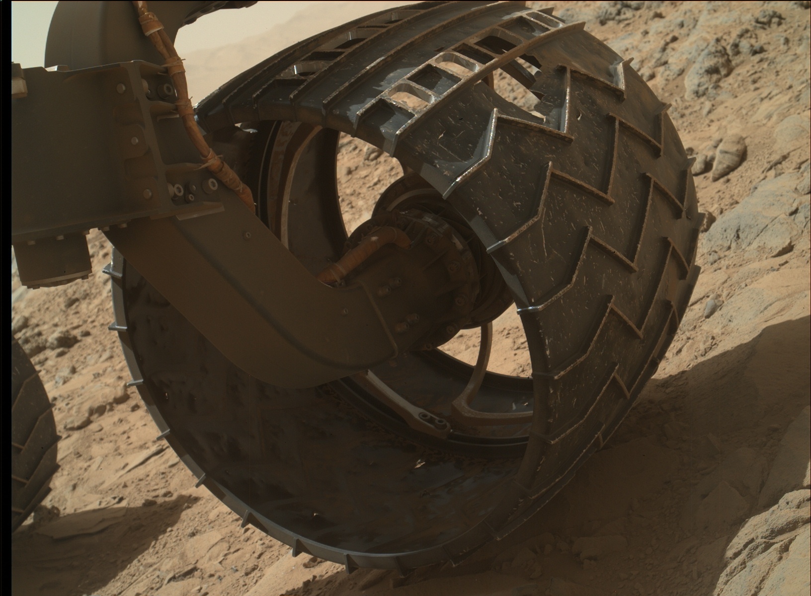
Though not serious at the moment, the wrong damage in the wrong place could be catastrophic to the mobility of the mission.
mars.jpl.nasa.gov...
Though not serious at the moment, the wrong damage in the wrong place could be catastrophic to the mobility of the mission.
reply to post by Blister
Yes, there are lots of pitfalls that Curiosity will have to avoid, and hopefully the wheel engineers took everything into account when designing and picking the material for the wheels.
I've watched the pathway to Mt. Sharp video about a dozen times now, full-screen, and it's a little hard to see a path past the sand dunes if and when Curiosity emerges from the Buttes. Does anyone know if a safe path has been seen by NASA and JPL map-techs? They must have, with the type of high-resolution cameras on the available overhead images, or at least think they have.
Will say, if I haven't before, what a great thread to map the Rover's journey with.
edit on 26-12-2013 by Aleister because: (no reason
given)
edit on 26-12-2013 by Aleister because: (no reason given)
reply to post by Aleister
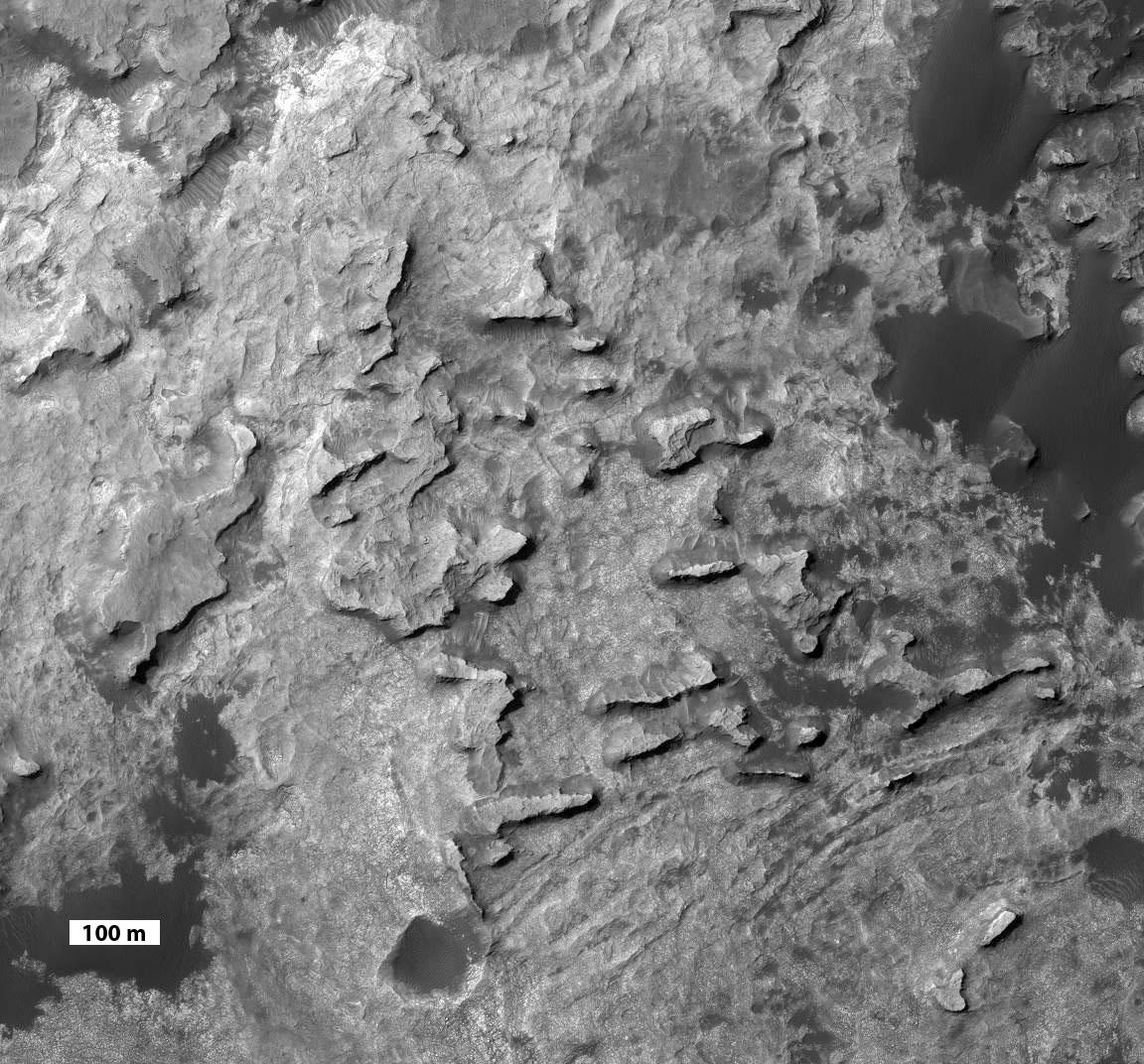
Once through the Buttes, Curiosity will have a good run toward the foothills. Here is a better view of Murray Buttes (North is upper right):
photojournal.jpl.nasa.gov...
photojournal.jpl.nasa.gov...
There do not appear to be large hazardous or dangerous dunes blocking the rover's route once it has traversed the Buttes.
reply to post by Blister
A perfect picture, thanks. From the video, JPL makes it look as if once past Murray Buttes (a name we will all become familiar with) more dark sand dune area will have to be passed. But their optimism is catching, from your source describing your picture:
They say the mountain slopes come just south of this pic, and you seem to have covered some of that route on the first page of the thread. Nice work, and I await the slow but sure progress of Curiosity as it travels to the Buttes, and because of you I now have a mental picture of where it's been and where's it's going.
And with all the fuss over Yellowknife Bay, look how tiny it is on the video you presented earlier. Thanks again!
A perfect picture, thanks. From the video, JPL makes it look as if once past Murray Buttes (a name we will all become familiar with) more dark sand dune area will have to be passed. But their optimism is catching, from your source describing your picture:
The scene covers a patch of ground about 0.8 mile (1.3 kilometers) across. North is up. The largest buttes in the group are about the size of a football field and the height of a goal post. Darker ground at upper right and lower left is part of sand dunes along the northern edge of Mount Sharp, within Gale Crater. Murray Buttes is located at a gap in that band of dunes, making passage through this area an attractive access route to the mountain slopes just south of this scene.
They say the mountain slopes come just south of this pic, and you seem to have covered some of that route on the first page of the thread. Nice work, and I await the slow but sure progress of Curiosity as it travels to the Buttes, and because of you I now have a mental picture of where it's been and where's it's going.
And with all the fuss over Yellowknife Bay, look how tiny it is on the video you presented earlier. Thanks again!
As of this moment the exact route of Curiosity after exiting from the Murray Buttes is undecided. So what follows is pure conjecture. Yep the stuff we
all thrive upon...
New photos of the possible area of entrance onto Mount Sharpe have come through from Curiosity. They are getting better all the time. Some viewers would say that these recent pictures are stunning.
Here are some of the possible amazing, incredible and historic sights awaiting MSL Curiosity and humanity as it nears the ascent. and drives past certain Objects of Interest:
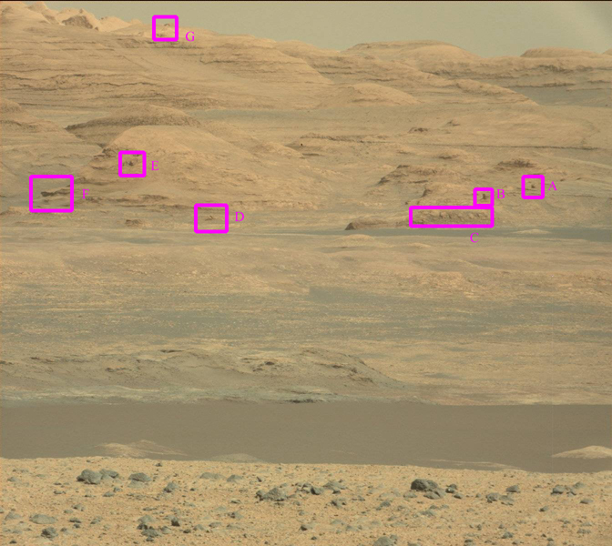
Source: mars.jpl.nasa.gov...
Also a close-up of F, "The Overview":
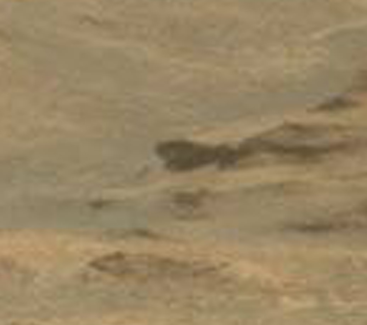
Source: mars.jpl.nasa.gov...
I won't discuss the annotated areas (I don't think I need to). If public wants to experiment with the photographs they are welcome. There are plenty of folk who will have their say in the future. Remember: you saw it here first.
New photos of the possible area of entrance onto Mount Sharpe have come through from Curiosity. They are getting better all the time. Some viewers would say that these recent pictures are stunning.
Here are some of the possible amazing, incredible and historic sights awaiting MSL Curiosity and humanity as it nears the ascent. and drives past certain Objects of Interest:
Source: mars.jpl.nasa.gov...
Also a close-up of F, "The Overview":
Source: mars.jpl.nasa.gov...
I won't discuss the annotated areas (I don't think I need to). If public wants to experiment with the photographs they are welcome. There are plenty of folk who will have their say in the future. Remember: you saw it here first.
reply to post by Blister
Thanks. Do you know how close Curiosity is to the approach to Murray Buttes? That trip through the buttes itself will be one of the most interesting of the journey, as there will be features there and "things" imbedded in the buttes that the rover can get its head around (in human terms). Every once in awhile I stop here just to watch the video of Curiosity's path.
Thanks. Do you know how close Curiosity is to the approach to Murray Buttes? That trip through the buttes itself will be one of the most interesting of the journey, as there will be features there and "things" imbedded in the buttes that the rover can get its head around (in human terms). Every once in awhile I stop here just to watch the video of Curiosity's path.
reply to post by Aleister
Curiosity should leave the Buttes some time in July to my best of knowledge. Possibly as early as June. But I could be wrong.
Curiosity should leave the Buttes some time in July to my best of knowledge. Possibly as early as June. But I could be wrong.
Blister
reply to post by Aleister
Curiosity should leave the Buttes some time in July to my best of knowledge. Possibly as early as June. But I could be wrong.
Ah, summer in the Buttes. Do you know how close the rover is to approaching or entering the buttes? I'm going to watch the video again to get another mental hold on the distance. Thanks.
EDIT: The video answers my question, it will arrive at the buttes in mid-2014. If folks watch the video it's really good in full-screen.
edit
on 21-1-2014 by Aleister because: (no reason given)
reply to post by ReconX
does the first image show an still active creek ??????? damn sure this looks like water
does the first image show an still active creek ??????? damn sure this looks like water
reply to post by Dynamitrios
The bluish dark patches are sand at the bottom of the valley. No running water here in recent history, sorry. Still there are some amazing geological sights, if the rover can get to them.
The bluish dark patches are sand at the bottom of the valley. No running water here in recent history, sorry. Still there are some amazing geological sights, if the rover can get to them.
Blister, come quick to this post and the few posts after it. You may be pleasantly surprised.
www.abovetopsecret.com...
www.abovetopsecret.com...
edit on 21-1-2014 by Aleister because: (no reason given)
Fantastic thread,right up my street. S and f, will comment later
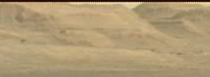
MSL Curiosity pictures from the last few Sols include some repeat shots, to check data. It is currently not intended that Curiosity venture as far
south as the arrow in the following picture suggests. However, following on from previous images of "The Overview", posted earlier, these latest ones
are extremely puzzling. Only traditionally acceptable explanation is that image artefact or obfuscation has occurred due to extreme distance being
photographed and associated environmental conditions.
Hope to get further pictures of "Longsight View" over the coming weeks and months to elaborate upon our understanding.
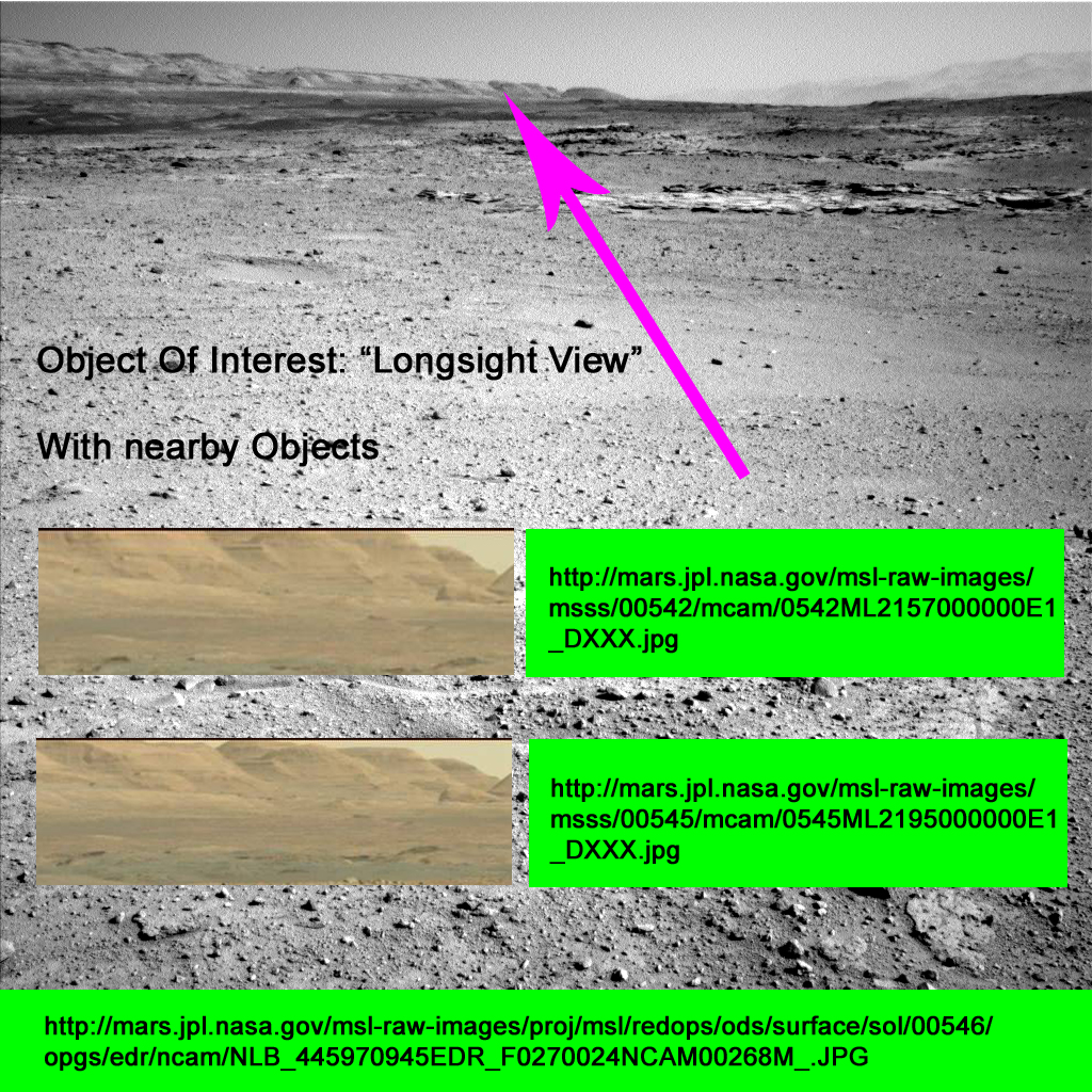
Sources:
mars.jpl.nasa.gov...
mars.jpl.nasa.gov...
mars.jpl.nasa.gov...
Here is a blow-up of the area:
Hope to get further pictures of "Longsight View" over the coming weeks and months to elaborate upon our understanding.
Sources:
mars.jpl.nasa.gov...
mars.jpl.nasa.gov...
mars.jpl.nasa.gov...
Here is a blow-up of the area:
edit on 18-2-2014 by Blister because: Add blow-up image
reply to post by Blister
Hi Blister, always glad to see this thread pop up on MyATS list.
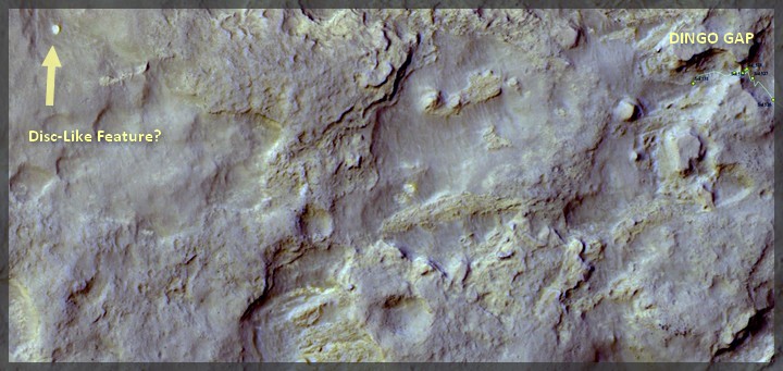
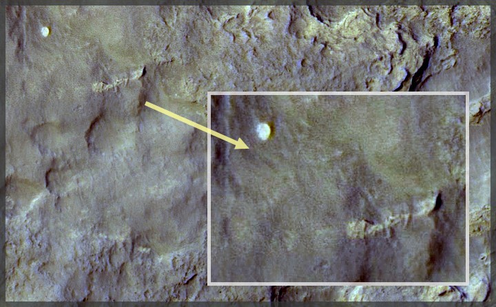
I didn't get what you meant, what's the puzzle? An item that funbox and Jeep have spotted on the anomalies thread may or may not be what you are pointing at here. Can this be it?
www.abovetopsecret.com... Jeep's post, and pics:
Hi Blister, always glad to see this thread pop up on MyATS list.
I didn't get what you meant, what's the puzzle? An item that funbox and Jeep have spotted on the anomalies thread may or may not be what you are pointing at here. Can this be it?
www.abovetopsecret.com... Jeep's post, and pics:
edit on 18-2-2014 by Aleister because: (no reason given)
edit on 18-2-2014 by Aleister because: (no reason
given)
edit on 18-2-2014 by Aleister because: (no reason given)
reply to post by Aleister
No, it is not the same thing as they seem to be playing with there. From the above image perspective (i.e. looking south), their white-ish "circle" object (possibly an eroded small, inverted crater?) is approximately 45 degrees west.
Cheers, Blister.
Edit: looking at the above pics you have posted here, it does look interesting.
edit on 18-2-2014 by Blister because: (no reason
given)
new topics
-
Australian PM says the quiet part out loud - "free speech is a threat to democratic dicourse"...?!
New World Order: 19 minutes ago -
Ireland VS Globalists
Social Issues and Civil Unrest: 50 minutes ago -
Biden "Happy To Debate Trump"
Mainstream News: 1 hours ago -
RAAF airbase in Roswell, New Mexico is on fire
Aliens and UFOs: 1 hours ago -
What is the white pill?
Philosophy and Metaphysics: 3 hours ago -
Mike Pinder The Moody Blues R.I.P.
Music: 3 hours ago -
Putin, Russia and the Great Architects of the Universe
ATS Skunk Works: 6 hours ago -
A Warning to America: 25 Ways the US is Being Destroyed
New World Order: 11 hours ago
top topics
-
President BIDEN's FBI Raided Donald Trump's Florida Home for OBAMA-NORTH KOREA Documents.
Political Conspiracies: 17 hours ago, 35 flags -
A Warning to America: 25 Ways the US is Being Destroyed
New World Order: 11 hours ago, 20 flags -
Mike Pinder The Moody Blues R.I.P.
Music: 3 hours ago, 7 flags -
What is the white pill?
Philosophy and Metaphysics: 3 hours ago, 5 flags -
Biden "Happy To Debate Trump"
Mainstream News: 1 hours ago, 5 flags -
RAAF airbase in Roswell, New Mexico is on fire
Aliens and UFOs: 1 hours ago, 4 flags -
Putin, Russia and the Great Architects of the Universe
ATS Skunk Works: 6 hours ago, 3 flags -
Australian PM says the quiet part out loud - "free speech is a threat to democratic dicourse"...?!
New World Order: 19 minutes ago, 3 flags -
Ireland VS Globalists
Social Issues and Civil Unrest: 50 minutes ago, 2 flags
active topics
-
Gaza Terrorists Attack US Humanitarian Pier During Construction
Middle East Issues • 81 • : KrustyKrab -
-@TH3WH17ERABB17- -Q- ---TIME TO SHOW THE WORLD--- -Part- --44--
Dissecting Disinformation • 694 • : Thoughtful3 -
University of Texas Instantly Shuts Down Anti Israel Protests
Education and Media • 282 • : Vermilion -
RAAF airbase in Roswell, New Mexico is on fire
Aliens and UFOs • 5 • : pianopraze -
Massachusetts Drag Queen Leads Young Kids in Free Palestine Chant
Social Issues and Civil Unrest • 19 • : LechPolish -
What is the white pill?
Philosophy and Metaphysics • 18 • : AllisVibration -
Starburst galaxy M82 - Webb Vs Hubble
Space Exploration • 9 • : Arbitrageur -
Biden "Happy To Debate Trump"
Mainstream News • 22 • : KrustyKrab -
Putin, Russia and the Great Architects of the Universe
ATS Skunk Works • 23 • : RussianTroll -
A Warning to America: 25 Ways the US is Being Destroyed
New World Order • 28 • : SchrodingersRat