It looks like you're using an Ad Blocker.
Please white-list or disable AboveTopSecret.com in your ad-blocking tool.
Thank you.
Some features of ATS will be disabled while you continue to use an ad-blocker.

How Google And Bing Maps Control What You Can See
page: 1share:
How Google And Bing Maps Control What You Can See
www.buzzfeed.com
(visit the link for the full news article)
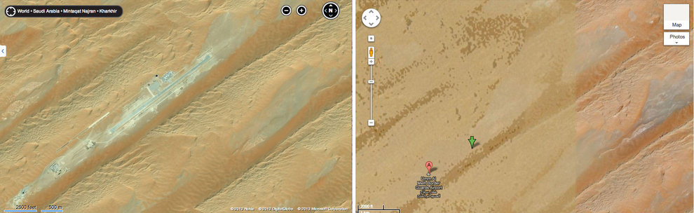
Google, Microsoft, DigitalGlobe, and the world's governments decide what does and doesn't belong on its surface. In early February, Wired published a satellite photo of a desert structure in southern Saudi Arabia. The image,...from Bing Maps, corresponded with a report that the CIA had built secret drone bases in the region. The site was available on any computer with a web browser, but appeared to be legit. Bing Maps, which is owned by Microsoft, had effectively outed a closely guarded...secret
While Microsoft admits to censoring data....
Google still denies it censors map data...although at
least here we do find confirmation that they do.
As just one example, the secret drone base revealed in Bing maps had been obscured in Google maps.
So...those blurred out images are just that...
blurred.
A fairly long article, with a lot of good information,
and some outgoing links with good info as well.
www.buzzfeed.com
(visit the link for the full news article)
Google still denies it censors map data...although at
least here we do find confirmation that they do.
As just one example, the secret drone base revealed in Bing maps had been obscured in Google maps.
Google, on the other hand, officially denies that it censors map data, telling BuzzFeed, "in occasional instances in which we receive government requests to blur portions of our imagery, we are always open to discussing those requests with public agencies and local officials. To date, none of these conversations has resulted in our blurring any imagery."
But there's a serious caveat: "Google Earth is built from a broad range of imagery providers, including public, government, commercial and private sector sources -- some of which may blur images before they supply it to us."
So...those blurred out images are just that...
blurred.
A fairly long article, with a lot of good information,
and some outgoing links with good info as well.
www.buzzfeed.com
(visit the link for the full news article)
reply to post by burntheships
Interesting, not surprising, but interesting.
I thought their comment about receiving blurred images was humorous.
It makes me wonder if they receive images showing something that is not there. A little disinformation and misdirection maybe?
Thanks for sharing this.
Interesting, not surprising, but interesting.
I thought their comment about receiving blurred images was humorous.
It makes me wonder if they receive images showing something that is not there. A little disinformation and misdirection maybe?
Thanks for sharing this.
Nothing unusual really, the SAS base in the UK is pretty much off limits even to the google cars driving along the public highway along side the
building, they know that for giving in on a few blurry snaps they can perhaps get a tax cut or something else
Originally posted by watchitburn
I thought their comment about receiving blurred images was humorous.
Yes, maybe each person has been given different talking points.
I suppose in the end, they just dont want that "censorship" word
related to the concept of "Google".
Did you know that the DoD limits the resolution of satellite imagery released to the public?
But I'm not sure why this is Breaking News.
And, oh yes...
www.buzzfeed.com...
But I'm not sure why this is Breaking News.
And, oh yes...
It's most probably, he says, that "they have different update schedules, and Microsoft got the data a little bit earlier."
www.buzzfeed.com...
edit on 3/3/2013 by Phage because: (no reason given)
Originally posted by Phage
Did you know that the DoD limits the resolution of satellite imagery released to the public?
Do you have any proof of that?
Please, share.
So, you have a sense of humor after all.
edit on 3-3-2013 by burntheships because: (no reason given)
reply to post by burntheships
www.spacecolorado.org...
Government would be allowed access to imagery at this highest resolution. All other customers would only receive imagery at the highest resolution allowed by U.S. regulations, currently 0.5-meter or 19.5 inch ground resolution.
The inference being that all remote imagery is downgraded in resolution (or definition, quality, detail) or otherwise censored, except for those in
Government or agencies thereof
So much for Google Earth, Moon, Mars...and doesn't leave much to the imagination when this policy is applied to space probe, NASA imagery either.
At least they finally admit they deliberately obscure publicly available imagery (apart from Google it seems)...it's a baby step in the right direction.
So much for Google Earth, Moon, Mars...and doesn't leave much to the imagination when this policy is applied to space probe, NASA imagery either.
At least they finally admit they deliberately obscure publicly available imagery (apart from Google it seems)...it's a baby step in the right direction.
I,have a sat Nav that shows every single new street here but on google maps a lot of them are missing. Even ones that have been built over 5 years
ago! Crazy...
reply to post by MysterX
Not an entirely valid inference. The DoD regulations apply only to satellite imagery, not aerial photography (much of which is used by Google).
The inference being that all remote imagery is downgraded in resolution (or definition, quality, detail) or otherwise censored, except for those in Government or agencies thereof
Not an entirely valid inference. The DoD regulations apply only to satellite imagery, not aerial photography (much of which is used by Google).
Of course they limit the resolution provided by satellite images. That should be a given.
I recently found out about ARGUS, man was I behind the loop. Check out what the government can do simply by wiring 300+ phone cams together. Then realize that this was with a cam made 4 years ago. That means they can do triple to quadruple that in the same space today! Makes me wonder what a perv could do with a small quadcopter or RC helicopter and a single cam flying just a few hundred feet up. It takes private investigation to a whole new level!
I recently found out about ARGUS, man was I behind the loop. Check out what the government can do simply by wiring 300+ phone cams together. Then realize that this was with a cam made 4 years ago. That means they can do triple to quadruple that in the same space today! Makes me wonder what a perv could do with a small quadcopter or RC helicopter and a single cam flying just a few hundred feet up. It takes private investigation to a whole new level!
edit on 3-3-2013 by nomnom because: (no reason given)
That really sucks that Google, a multinational corporation with no affiliation with the US government, is censoring info to protect the US government.
Didn't Google pick a bone with China about having to self-censor there? Yet they'll happily self-sensor to aid the US in it's bs imperial wars. I
guess they were never really genuine about opposing censorship in the first place.
edit on 3-3-2013 by SilentKoala because: (no reason
given)
reply to post by burntheships
While it is preposterous for anyone to believe that any government from any country in the World does not actively censor their on-line content for the "good" of everyone, and that even multi-billion dollar companies do the same (although in this instance, I would say it is more a matter of protecting their own investments in their company), it is unreasonable to jump to any conclusions about everything being a big cover-up, right down from strains of nasty deadly diseases running rampant through towns (and sometimes cities). A lot of it has to do with national security (such as air force secret experimental airplanes and other such research) so do not take everything at face value, simply because you are not able to see the full report.
Keep an open mind, for sure, as there is still quite a bit of information is keeping classified from the population World-wide, because just because you cannot see or access some files, videos, reports et cetera, could not necessarily mean anything to do with extraterrestrial life or anything of that nature.
reply to post by Tominiko
Hello, and welcome to ATS.
Yes, very valid points....
Perhaps some have missed the significance of the article, and the links found within.
Being new to the site, I would encourage you to check the entire write up out, it does
contain some fascinating finds, and gems.
The whole premise here is how these map sources hide and censor.
How, not if.....
edit on 3-3-2013 by burntheships because: (no reason given)
End of the day you have certain governments like the U.S that can basicaly chart other planets in our solar system. They can conduct geological
surveys on planets tens of millions of miles away. There is not a lot they do not see here on Earth.
Best thing to do would be to rent some time on satellite and have a look at the image quality yourself.
Best thing to do would be to rent some time on satellite and have a look at the image quality yourself.
reply to post by SilentKoala
Google
Yes, there was some back-n-forth with China and the NSA got involved on Google's behalf. As far as Google having no connection with the US Government.. well, that's not entirely accurate. They do release private information up to and including user's IP addresses to the US Government all the way down to the local-level Police.
It's alleged that it's for specific cases where it will help catch criminals.. but what exactly a criminal IS, is dictated by the law.. and who makes the laws? The US Government. So again, how soon before The Gov is just dipping its hand into Google's database without permission?
And that's JUST Google. There is no telling how much info Facebook leaks about it's users.
Facebook
So when we discuss how much of our visual information, i.e. maps, areal topography, etc are blurred, scarred, blacked out (like the Russian black rectangle).. It's happening. But we're just putting our heads in the sand and letting it happen.
Hi Phage. I can't say I'm shocked seeing you on this thread.
Yes, there was some back-n-forth with China and the NSA got involved on Google's behalf. As far as Google having no connection with the US Government.. well, that's not entirely accurate. They do release private information up to and including user's IP addresses to the US Government all the way down to the local-level Police.
It's alleged that it's for specific cases where it will help catch criminals.. but what exactly a criminal IS, is dictated by the law.. and who makes the laws? The US Government. So again, how soon before The Gov is just dipping its hand into Google's database without permission?
And that's JUST Google. There is no telling how much info Facebook leaks about it's users.
So when we discuss how much of our visual information, i.e. maps, areal topography, etc are blurred, scarred, blacked out (like the Russian black rectangle).. It's happening. But we're just putting our heads in the sand and letting it happen.
Hi Phage. I can't say I'm shocked seeing you on this thread.
reply to post by burntheships
What does it matter how they censor the maps? Doesn't it only matter that they do, in the end
What does it matter how they censor the maps? Doesn't it only matter that they do, in the end
Originally posted by nomnom
reply to post by burntheships
What does it matter how they censor the maps?
What matters to others may not matter to you.
edit on 4-3-2013 by burntheships because: (no reason given)
new topics
-
President BIDEN's FBI Raided Donald Trump's Florida Home for OBAMA-NORTH KOREA Documents.
Political Conspiracies: 1 hours ago -
Maestro Benedetto
Literature: 3 hours ago -
Is AI Better Than the Hollywood Elite?
Movies: 3 hours ago -
Las Vegas UFO Spotting Teen Traumatized by Demon Creature in Backyard
Aliens and UFOs: 6 hours ago -
2024 Pigeon Forge Rod Run - On the Strip (Video made for you)
Automotive Discussion: 7 hours ago -
Gaza Terrorists Attack US Humanitarian Pier During Construction
Middle East Issues: 8 hours ago -
The functionality of boldening and italics is clunky and no post char limit warning?
ATS Freshman's Forum: 9 hours ago -
Meadows, Giuliani Among 11 Indicted in Arizona in Latest 2020 Election Subversion Case
Mainstream News: 9 hours ago -
Massachusetts Drag Queen Leads Young Kids in Free Palestine Chant
Social Issues and Civil Unrest: 10 hours ago -
Weinstein's conviction overturned
Mainstream News: 11 hours ago
top topics
-
President BIDEN's FBI Raided Donald Trump's Florida Home for OBAMA-NORTH KOREA Documents.
Political Conspiracies: 1 hours ago, 13 flags -
Krystalnacht on today's most elite Universities?
Social Issues and Civil Unrest: 13 hours ago, 9 flags -
University of Texas Instantly Shuts Down Anti Israel Protests
Education and Media: 15 hours ago, 8 flags -
Supreme Court Oral Arguments 4.25.2024 - Are PRESIDENTS IMMUNE From Later Being Prosecuted.
Above Politics: 12 hours ago, 8 flags -
Gaza Terrorists Attack US Humanitarian Pier During Construction
Middle East Issues: 8 hours ago, 7 flags -
Weinstein's conviction overturned
Mainstream News: 11 hours ago, 7 flags -
Massachusetts Drag Queen Leads Young Kids in Free Palestine Chant
Social Issues and Civil Unrest: 10 hours ago, 7 flags -
Meadows, Giuliani Among 11 Indicted in Arizona in Latest 2020 Election Subversion Case
Mainstream News: 9 hours ago, 5 flags -
Las Vegas UFO Spotting Teen Traumatized by Demon Creature in Backyard
Aliens and UFOs: 6 hours ago, 4 flags -
2024 Pigeon Forge Rod Run - On the Strip (Video made for you)
Automotive Discussion: 7 hours ago, 3 flags
active topics
-
Supreme Court Oral Arguments 4.25.2024 - Are PRESIDENTS IMMUNE From Later Being Prosecuted.
Above Politics • 83 • : Sookiechacha -
President BIDEN's FBI Raided Donald Trump's Florida Home for OBAMA-NORTH KOREA Documents.
Political Conspiracies • 3 • : xuenchen -
Is AI Better Than the Hollywood Elite?
Movies • 10 • : 5thHead -
Sol Et Luna - TIME2024
Short Stories • 10 • : BrotherKinsMan -
University of Texas Instantly Shuts Down Anti Israel Protests
Education and Media • 263 • : cherokeetroy -
Massachusetts Drag Queen Leads Young Kids in Free Palestine Chant
Social Issues and Civil Unrest • 13 • : ToneD -
Gaza Terrorists Attack US Humanitarian Pier During Construction
Middle East Issues • 26 • : nugget1 -
British TV Presenter Refuses To Use Guest's Preferred Pronouns
Education and Media • 168 • : Annee -
Manly P. Hall says Freemasonry is a religion?
Secret Societies • 22 • : Therealbeverage -
One Flame Throwing Robot Dog for Christmas Please!
Weaponry • 11 • : Therealbeverage