It looks like you're using an Ad Blocker.
Please white-list or disable AboveTopSecret.com in your ad-blocking tool.
Thank you.
Some features of ATS will be disabled while you continue to use an ad-blocker.

Quake Watch 2013
page: 46share:
28min ago
cnt.rm.ingv.it...
these are never good
Event-ID 7226841560
Magnitudo(Ml) [color=violet]4.8ML
Data-Ora 16/02/2013 alle 22:16:09 (italiane)
16/02/2013 alle 21:16:09 (UTC)
Coordinate 41.714°N, 13.576°E
Profondità 10.7 km
Distretto sismico Monti_Ernici-Simbruini
cnt.rm.ingv.it...
these are never good
edit on 16-2-2013 by muzzy because: (no reason given)
Originally posted by aLLeKs
I am not sure, why the Dolphins should have anything to do with earthquakes...
Probably hard to imagine when you are bi-pedal upright humanoid living on dry land.
Vibrations man!
reply to post by muzzy
SO close to Rome. Hope all is ok.
earthquake-report.com... Makes like people were frightened, but was not a long shaking and the fact people felt a mostly vertical movement and not horizontal is a good thing.
SO close to Rome. Hope all is ok.
earthquake-report.com... Makes like people were frightened, but was not a long shaking and the fact people felt a mostly vertical movement and not horizontal is a good thing.
edit on 16-2-2013 by MamaJ because: (no reason
given)
Originally posted by Psychoparrot
Originally posted by aLLeKs
I am not sure, why the Dolphins should have anything to do with earthquakes...
Probably hard to imagine when you are bi-pedal upright humanoid living on dry land.
Vibrations man!
I know what you all want to say with it, but it lacks some scientific proof right? Maybe they just discovered a nice source of food
Originally posted by muzzy
28min ago
Event-ID 7226841560
Magnitudo(Ml) [color=violet]4.8ML
Data-Ora 16/02/2013 alle 22:16:09 (italiane)
16/02/2013 alle 21:16:09 (UTC)
Coordinate 41.714°N, 13.576°E
Profondità 10.7 km
Distretto sismico Monti_Ernici-Simbruini
cnt.rm.ingv.it...
these are never good
Doesn't look like this earthquake is going to have the same effects as the Garfagnana one on 25/01/2013,
only 11 aftershocks in the first 1 3/4 hrs where as Garfagnana had 35
1.3, 16/02/2013 22:58:11, 41.726, 13.568, 19.9, Via Carpine, 50, Sora, Province of Frosinone
1.4, 16/02/2013 22:42:52, 41.725, 13.571, 19.5, Via Carpine, 50, Sora, Province of Frosinone
1.1, 16/02/2013 22:27:40, 41.723, 13.607, 17.1, Via Giacomo Matteotti, 38, Sora, Province of Frosinone
2.3, 16/02/2013 22:24:57, 41.721, 13.612, 16.4, Via Quarto, 37, Sora, Province of Frosinone
2.3, 16/02/2013 22:24:57, 41.728, 13.613, 17, Via Spinelle, Sora, Province of Frosinone
2.2, 16/02/2013 22:24:57, 41.719, 13.6, 16.2, Via S. Maria Pietra, 29, Sora, Province of Frosinone
1.5, 16/02/2013 22:14:23, 41.727, 13.562, 18, Via Grignano, 130, Sora, Province of Frosinone
1.2, 16/02/2013 21:56:39, 41.72, 13.612, 16.5, Via Giovanni Branca, 61, Sora, Province of Frosinone
1.3, 16/02/2013 21:44:06, 41.726, 13.578, 18.6, Via Carpine, 50, Sora, Province of Frosinone
1.2, 16/02/2013 21:42:55, 41.72, 13.581, 15.8, Via Carpine, 60, Sora, Province of Frosinone
1.7, 16/02/2013 21:38:18, 41.707, 13.599, 16, Via Cellaro, 30, Sora, Province of Frosinone
4.8, 16/02/2013 21:16:09, 41.714, 13.576, 10.7, Via Scocciaformiche, 40, Sora, Province of Frosinone
I've just updated Italia 2013 map to the last quake on the data at 16/02/2013 10:58:11 p.m.UTC
map zoomed into Sora, Province of Frosinone, Italy
quite a built-up area
there were a few quakes there yesterday, I wonder if the people there were made aware of the "foreshocks"? , only mag 1's though
edit:
I see USGS has converted this to 4.9Mw, the same as Garfagnana, lets hope these aren't just foreshocks of something bigger.
edit on 16-2-2013 by muzzy because: (no reason given)
Originally posted by Roald
Would we "soon" be in for a magnitude 8 to 9 earthquake in the Main Himalayan Thrust?
I'm asking because there have been detection of magma and water around the MHT and data has showed a thrust dipping in two to four degrees northward, and also revealed a segment of thrust that dips 15 degrees downward.
I guess a ramp such as that one could be a nucleation point for a massive earthquake?
QuakeSim Forecast says No.
Slightly elevated risk behind the Himalayas though, in Tibet
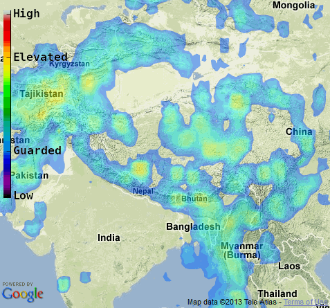
of course nature rarely follows forecasts
Santa Cruz was "High Probability" so you do have to give them a half chance.
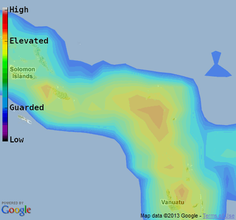
The Sth E Alaska 7.5 was in a Light Blue "Guarded-Elevated" region and
Columbia Mag7 quake on the 9th was on the edge of a "Guarded" (blue) section, so anything could happen
Global forecast of future earthquake activity produced by the Open Hazards Group a spin-off from QuakeSim. The colors indicate the probability of an M>6.5 earthquake within 50 km of each site during the next year. A scale is shown at left for reference.
edit on 16-2-2013 by muzzy
because: (no reason given)
Update on Italy at 17/02/2013 04:26:18
5 more aftershocks at Sora, Province of Frosinone map
but also a new mag 3.7 at Gran Sasso e Monti della Laga National Park, 64043 L'Aquila, Province of L'Aquila with 22 aftershocks map
geez even the little ones set of a flurry of tappers (little aftershocks) there
5 more aftershocks at Sora, Province of Frosinone map
but also a new mag 3.7 at Gran Sasso e Monti della Laga National Park, 64043 L'Aquila, Province of L'Aquila with 22 aftershocks map
geez even the little ones set of a flurry of tappers (little aftershocks) there
edit on 17-2-2013 by muzzy because: had the wrong day and
time for the last quake (update time), after a while the numbers all look the same.
Originally posted by aLLeKs
Originally posted by Psychoparrot
Originally posted by aLLeKs
I am not sure, why the Dolphins should have anything to do with earthquakes...
Probably hard to imagine when you are bi-pedal upright humanoid living on dry land.
Vibrations man!
I know what you all want to say with it, but it lacks some scientific proof right? Maybe they just discovered a nice source of food
Going out on a limb here, but do you not remember the articles about the bumper catch of squid in Japan just prior to the Japan 2011 quake?
Squid fishermen in Tokushima Prefecture hauled in a bumper catch just before the massive March 11 earthquake, just as they did right before the 1995 Great Hanshin Earthquake, leading to suggestions the phenomenons could be connected.
Some fishermen believe a large haul of squid might be a sign that a major earthquake is about to strike, a theory one expert called "intriguing."
A fishery cooperative in Komatsushima in the prefecture said about 200 tons of squid were landed during the peak months of January and February--between two and four times more than in a regular year. A fishery co-op in northern Tokushima reported this winter's squid catch of 70 tons was triple that of a standard year.
www.yomiuri.co.jp...
So, according to the article, they've had huge squid hauls before past big 'quakes, as well. Now, how does that relate to dolphins? Well, if something disturbed the squid in Japan enough to be caught in such high numbers before 'quakes, would it not be plausible to consider that the food sources the 100,000 dolphins are feasting on could have been driven out of their normal area(s) by something? That's a lot of food in one spot for that many dolphins to comfortably munch on, when you think about it. Then again, it could just be one big party under the waves that is rare to catch happening. Who knows. Point is, we shouldn't brush it off as no big deal because it could be a useful warning from the ocean dwellers. After all, more of this planet is under water than above it, and we landlubber bipeds still have a lot to learn.
reply to post by Nyiah
makes sence....! when an EQ occures then lots of nutriciants comes loose from the sea-floor ....
makes sence....! when an EQ occures then lots of nutriciants comes loose from the sea-floor ....
reply to post by muzzy
How do we know if these in Italy are for sure aftershocks?
Also, I heard people there were/are really frightened. One woman died of a heart attack.
How do we know if these in Italy are for sure aftershocks?
Also, I heard people there were/are really frightened. One woman died of a heart attack.
NV & AK were the front runners for small quakes earlier today.
But now CA is ahead with 50.
NV-12 AK-18.
earthquake.usgs.gov...
The aftershocks in NV:
earthquake.usgs.gov...
earthquake.usgs.gov...
the swarm in CA:
earthquake.usgs.gov...
earthquake.usgs.gov...
But there are others scattered all over the place.
Like someone took a handful of blue pebbles & threw them on a map!
All the way from 32* to 40* LAT.
earthquake.usgs.gov...
Source: USGS
WOQ
edit on 17-2-2013 by wasobservingquietly because: Added lists!
edit on 17-2-2013 by wasobservingquietly because:
Booboo!
Originally posted by MamaJ
reply to post by muzzy
How do we know if these in Italy are for sure aftershocks?
Also, I heard people there were/are really frightened. One woman died of a heart attack.
Until something bigger comes along they are aftershocks of the 4.8
if something bigger comes along then these are foreshocks of that one
if another 4.8 comes along then its a swarm
there is no fixed timeline on those either, the Pollino 25/10/2012 5.0ML had 360 minor quakes in the month prior, and also had other swarms in April, Nov/Dec 2011 and in Oct 2010 that never amounted to anything major.
A swarm is where there is no obvious large magnitude Mainshock
L'Aquila had 484 minor quakes in the 90 days prior (foreshocks) to the devestating 2009 mag 5.9ML
and 17,040 aftershocks in the 269 days afterwards (still working on that one)
but having looked at the history of this spot (Sora) since June last year (using the maps on my Italia page) there was nothing going on, it basically started on the 15th Feb @ 18:58 UTC with a mag 1.1
I'm gradually building up a catalog of the bigger quakes there
Earthquake Archives Italia
reply to post by muzzy
Not sure how you read high from that? I read that as the high end of Elevated.
Frankly their forecasts are as much of a waste of time as anyone else. There is a likelihood of and M6 in Vanuatu? Well whoopy DS. I think we can deduce that without all the funding!
In Vanuatu, or any of the other places they single out. Yup I think you would be safe betting on that. What a load of BS. If they were forecasting somewhere as high and it happen I would be impressed. There is nowhere on the map as high. Best they predict is top end of elevated in all the most likely places. Wool and eyes come to mind.
And anyway it is NASA so it is bound to be wrong
Santa Cruz was "High Probability" so you do have to give them a half chance.
Not sure how you read high from that? I read that as the high end of Elevated.
Frankly their forecasts are as much of a waste of time as anyone else. There is a likelihood of and M6 in Vanuatu? Well whoopy DS. I think we can deduce that without all the funding!
The colors indicate the probability of an M>6.5 earthquake within 50 km of each site during the next year.
In Vanuatu, or any of the other places they single out. Yup I think you would be safe betting on that. What a load of BS. If they were forecasting somewhere as high and it happen I would be impressed. There is nowhere on the map as high. Best they predict is top end of elevated in all the most likely places. Wool and eyes come to mind.
And anyway it is NASA so it is bound to be wrong
QuakeSim is sponsored by NASA's Earth Science Technology Office under the Advanced Information Systems Technology Program.
reply to post by PuterMan
Is that to be taken as sarcastic?
And anyway it is NASA so it is bound to be wrong
Is that to be taken as sarcastic?
Region: KERMADEC ISLANDS, NEW ZEALAND
Geographic coordinates: 30.682S, 178.127W
Magnitude: 6.1
Depth: 34 km
Universal Time (UTC): 18 Feb 2013 12:19:19
Time near the Epicenter: 19 Feb 2013 00:19:19
Local standard time in your area: 18 Feb 2013 12:19:19
Location with respect to nearby cities:
161 km (100 miles) S (189 degrees) of Raoul Island, Kermadec Islands
1099 km (683 miles) SSW (195 degrees) of NUKU'ALOFA, Tonga
3233 km (2009 miles) WSW (238 degrees) of PAPEETE, Tahiti, French Polynesia
Another one ....
Region: KERMADEC ISLANDS, NEW ZEALAND
Geographic coordinates: 30.694S, 178.135W
Magnitude: 5.6
Depth: 36 km
Universal Time (UTC): 18 Feb 2013 16:32:46
Time near the Epicenter: 19 Feb 2013 04:32:46
Local standard time in your area: 18 Feb 2013 16:32:46
Location with respect to nearby cities:
163 km (101 miles) S (189 degrees) of Raoul Island, Kermadec Islands
1100 km (684 miles) SSW (195 degrees) of NUKU'ALOFA, Tonga
3234 km (2010 miles) WSW (238 degrees) of PAPEETE, Tahiti, French Polynesia
reply to post by PuterMan
Having looked at some of the orange areas close up I think they should have brought the whole colour range up a notch, It may just be the spectrum is faded by the backgrounds, where there is sea is blue so put red over blue and it turns to orange.
I checked a few more, like the Ruakumara Plain mag 6.3 on the weekend and the area by the January St E Alaska and both were "close" but not as close as Santa Cruz was.
Its up to people to make of it whatever they see, for those who don't follow earthquakes every day, like 99% of the population, these maps may be educational.
I was reading about L'Aquila yesterday and found some interesting stuff, this excerpt from a pdf that INGV put out in defense of the scientists who got jailed.
www.ingv.it...
Like it says "here is your map, use it to get ready, don't blame us if you ignore it" but the authorities didn't and then they blamed the geologists
There are some good links at the bottom of this page ( they linked to in the pdf)
The Japan Hazard map is interesting in that it was done in 2005, and has the red parts along the south coast of Honshu, and they only present the land based risk, so missed the off the East Coast of Honshu 2011 www.jishin.go.jp...
Same with the NZ one, Christchurch wasn't even on the band of red/orange running down the spine of the South Island, now in 2013 it has its own orange /red patch, because it came out of the blue.
So don't be surprised if some big quakes literally do come out of the blue ( blue band on the QuakeSim map)
Having looked at some of the orange areas close up I think they should have brought the whole colour range up a notch, It may just be the spectrum is faded by the backgrounds, where there is sea is blue so put red over blue and it turns to orange.
I checked a few more, like the Ruakumara Plain mag 6.3 on the weekend and the area by the January St E Alaska and both were "close" but not as close as Santa Cruz was.
Its up to people to make of it whatever they see, for those who don't follow earthquakes every day, like 99% of the population, these maps may be educational.
I was reading about L'Aquila yesterday and found some interesting stuff, this excerpt from a pdf that INGV put out in defense of the scientists who got jailed.
Seismologists have developed and made available to the Country, the Italian Seismic Hazard Map, the latest update become a national law in 2006-three years before the earthquake hit L'Aquila
(http:// www.mi.ingv . it /Hazard-Earthquake/ ). This map, which is a very important tool to
reduce the seismic risk, is well known. On the Map L'Aquila is located in an area where the
seismic hazard is maximum, regardless of the occurrence of moderate-low magnitude seismic
sequences. The map was discussed at the meeting of 31 March 2009. So the "alarm" and risk
communication were clearly released by seismologists..................
www.ingv.it...
Like it says "here is your map, use it to get ready, don't blame us if you ignore it" but the authorities didn't and then they blamed the geologists
There are some good links at the bottom of this page ( they linked to in the pdf)
The Japan Hazard map is interesting in that it was done in 2005, and has the red parts along the south coast of Honshu, and they only present the land based risk, so missed the off the East Coast of Honshu 2011 www.jishin.go.jp...
Same with the NZ one, Christchurch wasn't even on the band of red/orange running down the spine of the South Island, now in 2013 it has its own orange /red patch, because it came out of the blue.
So don't be surprised if some big quakes literally do come out of the blue ( blue band on the QuakeSim map)
edit on 18-2-2013 by muzzy because: (no reason given)
Originally posted by muzzy
reply to post by PuterMan
The point, which you may have missed, is that on that map every area where they show a likelihood of a Mag 6.5+ in the next year is an area where there is a likelihood of a mag 6.5+ in the next year. That being that case you or I or anyone with an interest in M6+ quakes could have devised that map. It says nothing new.
Really Muzzy that says it all doesn't it. They colour the map now because something took them by surprise that they had not allowed for and you say this may happen again, which makes it a completely pointless exercise. I am afraid as far as I am concerned it fails to match all the criteria required to be a reliable prediction tool.
Next please....
reply to post by PuterMan
The point, which you may have missed, is that on that map every area where they show a likelihood of a Mag 6.5+ in the next year is an area where there is a likelihood of a mag 6.5+ in the next year. That being that case you or I or anyone with an interest in M6+ quakes could have devised that map. It says nothing new.
Same with the NZ one, Christchurch wasn't even on the band of red/orange running down the spine of the South Island, now in 2013 it has its own orange /red patch, because it came out of the blue.
So don't be surprised if some big quakes literally do come out of the blue ( blue band on the QuakeSim map)
Really Muzzy that says it all doesn't it. They colour the map now because something took them by surprise that they had not allowed for and you say this may happen again, which makes it a completely pointless exercise. I am afraid as far as I am concerned it fails to match all the criteria required to be a reliable prediction tool.
Next please....
new topics
-
President BIDEN's FBI Raided Donald Trump's Florida Home for OBAMA-NORTH KOREA Documents.
Political Conspiracies: 50 minutes ago -
Maestro Benedetto
Literature: 2 hours ago -
Is AI Better Than the Hollywood Elite?
Movies: 2 hours ago -
Las Vegas UFO Spotting Teen Traumatized by Demon Creature in Backyard
Aliens and UFOs: 6 hours ago -
2024 Pigeon Forge Rod Run - On the Strip (Video made for you)
Automotive Discussion: 6 hours ago -
Gaza Terrorists Attack US Humanitarian Pier During Construction
Middle East Issues: 7 hours ago -
The functionality of boldening and italics is clunky and no post char limit warning?
ATS Freshman's Forum: 8 hours ago -
Meadows, Giuliani Among 11 Indicted in Arizona in Latest 2020 Election Subversion Case
Mainstream News: 8 hours ago -
Massachusetts Drag Queen Leads Young Kids in Free Palestine Chant
Social Issues and Civil Unrest: 9 hours ago -
Weinstein's conviction overturned
Mainstream News: 10 hours ago
top topics
-
Krystalnacht on today's most elite Universities?
Social Issues and Civil Unrest: 12 hours ago, 9 flags -
University of Texas Instantly Shuts Down Anti Israel Protests
Education and Media: 14 hours ago, 8 flags -
Supreme Court Oral Arguments 4.25.2024 - Are PRESIDENTS IMMUNE From Later Being Prosecuted.
Above Politics: 12 hours ago, 8 flags -
Gaza Terrorists Attack US Humanitarian Pier During Construction
Middle East Issues: 7 hours ago, 7 flags -
Weinstein's conviction overturned
Mainstream News: 10 hours ago, 7 flags -
Massachusetts Drag Queen Leads Young Kids in Free Palestine Chant
Social Issues and Civil Unrest: 9 hours ago, 7 flags -
President BIDEN's FBI Raided Donald Trump's Florida Home for OBAMA-NORTH KOREA Documents.
Political Conspiracies: 50 minutes ago, 6 flags -
Meadows, Giuliani Among 11 Indicted in Arizona in Latest 2020 Election Subversion Case
Mainstream News: 8 hours ago, 5 flags -
Las Vegas UFO Spotting Teen Traumatized by Demon Creature in Backyard
Aliens and UFOs: 6 hours ago, 4 flags -
Chris Christie Wishes Death Upon Trump and Ramaswamy
Politicians & People: 12 hours ago, 2 flags
active topics
-
HORRIBLE !! Russian Soldier Drinking Own Urine To Survive In Battle
World War Three • 46 • : Xtrozero -
Supreme Court Oral Arguments 4.25.2024 - Are PRESIDENTS IMMUNE From Later Being Prosecuted.
Above Politics • 80 • : WeMustCare -
University of Texas Instantly Shuts Down Anti Israel Protests
Education and Media • 242 • : cherokeetroy -
Massachusetts Drag Queen Leads Young Kids in Free Palestine Chant
Social Issues and Civil Unrest • 12 • : SchrodingersRat -
SETI chief says US has no evidence for alien technology. 'And we never have'
Aliens and UFOs • 73 • : SchrodingersRat -
Is AI Better Than the Hollywood Elite?
Movies • 5 • : 5thHead -
New whistleblower Jason Sands speaks on Twitter Spaces last night.
Aliens and UFOs • 62 • : pianopraze -
Alternate Electors vs Fake Electors - What is the Difference.
2024 Elections • 115 • : WeMustCare -
Sunak spinning the sickness figures
Other Current Events • 24 • : NoCorruptionAllowed -
Nearly 70% Of Americans Want Talks To End War In Ukraine
Political Issues • 95 • : Irishhaf