It looks like you're using an Ad Blocker.
Please white-list or disable AboveTopSecret.com in your ad-blocking tool.
Thank you.
Some features of ATS will be disabled while you continue to use an ad-blocker.

Quake Watch 2013
page: 3share:
Magnitude: 5.7
DateTime: Tuesday January 1 2013, 07:35:50 UTC
Region: Kuril Islands
Depth: 48.7 km
Source: USGS Feed
quakes.globalincidentmap.com...
Magnitude 5.7
Date-Time
Tuesday, January 01, 2013 at 07:35:50 UTC
Tuesday, January 01, 2013 at 06:35:50 PM at epicenter
Time of Earthquake in other Time Zones
Location 46.904°N, 151.023°E
Depth 48.7 km (30.3 miles)
Region KURIL ISLANDS
Distances 274 km (170 miles) SE of Vostok, Russia
584 km (362 miles) NE of Nemuro, Japan
585 km (363 miles) NE of Shibetsu, Japan
617 km (383 miles) ENE of Abashiri, Japan
Location Uncertainty horizontal +/- 17.5 km (10.9 miles); depth +/- 8.8 km (5.5 miles)
Parameters NST=477, Nph=480, Dmin=728 km, Rmss=0.62 sec, Gp= 76°,
M-type=body wave magnitude (Mb), Version=9
Source
Magnitude: USGS NEIC (WDCS-D)
Location: USGS NEIC (WDCS-D)
Event ID usc000ei4d
edit on 7/30/2012 by dreamfox1 because: earthquake.usgs.gov...
I watch the usgs quake data every day, and it seems to be eerily quiet lately. Trends that I have noticed when it quiets down is that a major
normally follows. Not sure of any quake watches at this time, but I lost all of my links and accumulated data when my computer crashed.
Massive quake may hit the Himalayas
SOURCE
In what can have huge implications for countries like India, scientists have warned of massive earthquakes in the Himalayas, especially in areas where the surface is yet to be broken by a tremblor.
The study showed that in 1255 and 1934, two great earthquakes ruptured the ground surface in the Himalayas. This runs contrary to what scientists previously thought.
reply to post by dreamfox1
welcome to 2013 dreamfox
a bit of advice , be careful of posting links that will become obsolete
that usgs link will eventually disappear, according to the warning
as advised by USGS above the best page to link to would be earthquake.usgs.gov...
no one in a couple of months wants to read a forum that is full of dead links eh
having said that, they have been warning of this for about 6 months, I would have thought Jan 1st 2013 would have been the best time to make the change.
welcome to 2013 dreamfox
a bit of advice , be careful of posting links that will become obsolete
that usgs link will eventually disappear, according to the warning
This webpage is being phased out and is no longer maintained. Please use the new Real-time Earthquake Map instead and update your bookmark. See Quick Tips & User Guide.
as advised by USGS above the best page to link to would be earthquake.usgs.gov...
no one in a couple of months wants to read a forum that is full of dead links eh
having said that, they have been warning of this for about 6 months, I would have thought Jan 1st 2013 would have been the best time to make the change.
edit on 1-1-2013 by muzzy because: (no reason given)
quote from the article "Massive earthquakes are not unknown in the Himalayas, as quakes in 1897, 1905, 1934 and 1950.........."
reply to post by happykat39
The article didn't mention 1833,
The others mentioned, in 1897 and 1905 must have just been 7's which are classified as "very strong" not "major" or "massive"
India is a hard nut to crack, all their earthquake reporting web sites are riddled with internet virus's, be warned
reply to post by happykat39
Date/Time: 1934/1/15 8:43:
Lat: 26.5 Long: 86.5
Region: Bihar, India - Nepal
Mw: 8.1 Ms: n/a
Mb: n/a ML: n/a
Me: n/a Unk: 8.3
Depth: 25 km
Deaths: 10000 , Injuries: n/a
Tsunami: yes
Source: noaa
Extreme damage (X) in the Sitamarhi-Madhubani, India area, where most buildings tilted or sank up to 1 m (3 ft) into the thick alluvium. Sand covered the sunken floors up to 1 m deep. This liquefaction damage extended eastward through Supaul to Purnia, India. In the Muzaffarpur-Darbhanga area south of the zone of liquefaction most buildings were shaken apart. Two other areas of extreme damage (X) from shaking occurred in the Munger (Monghyr) area along the Ganges River, India and in the Kathmandu Valley, Nepal. Large fissures occurred in the alluvial areas. The impact was reported to be felt in Lhasa in the north to Bombay (Mumbai) in the south, Assam in the east to Punjab in the west. The earthquake was so severe that in Kolkata, (around 650 km from epicenter) many buildings were damaged and tower of St. Paul Cathedral collapsed. In Sitamarhi, not a single house was left standing.In Rajnagar, near Madhubani all the Kutcha buildings collapsed.
1934
The article didn't mention 1833,
Date/Time: 1833/8/26 17:0:- Local
Lat: 28.3 Long: 85.5
Location: Nepal:Langtang
Magnitude: 8 Unk
Depth: - km
Source: Ko et al (1983, 1984), Sha et al (1983-1987)
All Mag 8 + Quakes 314-2012
Date/Time: 1950/8/15 14:9:30
Lat: 28.5 Long: 96.5
Region: Arunachal Pradesh, India/Tibet border area
Mw: 8.6 [p&s] Ms: 8.6 [abe]
Mb: 8.0 [abe] ML: n/a
Me: n/a Unk: 8.6 [g&r]
Depth: n/a km
Deaths: 1530 , Injuries: n/a
Tsunami: yes
Source: noaa noaa
At least 780 people killed and many buildings collapsed in the Nyingchi-Qamdo-Zhamo (Rima, Zayu) area of eastern Tibet. Sandblows, ground cracks and large landslides occurred in the area. In the Medog area, the village of Yedong slid into the Yarlung Zangbo (Brahmaputra) River and was washed away. The quake was felt at Lhasa and in Sichuan and Yunnan Provinces, China. Severe damage (X) also occurred in the Sibsagar-Sadiya area of Assam, India and in the surrounding hills. About 70 villages were destroyed in the Abor Hills, mostly by landslides. Large landslides blocked the Subansiri River. This natural dam broke 8 days later, creating a wave 7 m (23 ft) high which innundated several villages and killed 536 people. The quake was felt (VI) as far away as Calcutta. Seiches were observed in many lakes and fjords of Norway and in at least 3 reservoirs in England. Many sources call this the Assam-Tibet earthquake or even the Assam earthquake, even though nearly all place the epicenter in Tibet. Thus it is possible that the casualties for Tibet are not included in the total, as well as those from the Subansiri River flood. Furthermore, Gu et al. do not give casualty totals for Yedong or other areas of the most severe damage in Tibet. Therefore, the actual casualty toll may be much higher than the value given
1950
The others mentioned, in 1897 and 1905 must have just been 7's which are classified as "very strong" not "major" or "massive"
edit on 1-1-2013 by muzzy because: (no reason given)
India is a hard nut to crack, all their earthquake reporting web sites are riddled with internet virus's, be warned
edit on 1-1-2013 by
muzzy because: (no reason given)
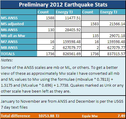
The number of quakes reported by USGS in the 7 day reports was 116 so the ANSS number is 14 higher. If you convert all mb and ML value to approximate Mw values then some (5) Mag 5 get uplifted to Mag 6 so you could sya that the accurate figure, if any figure can be accurate, is 135.
Until I got the ANSS figure I though my prediction of 1 x M8, 16 x M7, 120 x M6 was not too bad, but it transpires that instead of 5 x M6 under the final figure is 10 x Mg 0ver and 1 x M8 over, but 1 x 7 under.
Still seeing that no one believed me at the start of last year and many were predicting massive quakes, i sort of feel vindicated. I said it would be quieter and it was.
Originally posted by PuterMan
The number of quakes reported by USGS in the 7 day reports was 116 so the ANSS number is 14 higher. If you convert all mb and ML value to approximate Mw values then some (5) Mag 5 get uplifted to Mag 6 so you could sya that the accurate figure, if any figure can be accurate, is 135.
Until I got the ANSS figure I though my prediction of 1 x M8, 16 x M7, 120 x M6 was not too bad, but it transpires that instead of 5 x M6 under the final figure is 10 x Mg 0ver and 1 x M8 over, but 1 x 7 under.
Still seeing that no one believed me at the start of last year and many were predicting massive quakes, i sort of feel vindicated. I said it would be quieter and it was.
How dare they question THE Jedi master
Originally posted by Jusvistn
I watch the usgs quake data every day, and it seems to be eerily quiet lately. Trends that I have noticed when it quiets down is that a major normally follows. Not sure of any quake watches at this time, but I lost all of my links and accumulated data when my computer crashed.
I have the same feeling. But normally I only care about 6.0+ ones... so it got really quiet
further to post by muzzy
18 aftershocks of the 4.9 , thats quite a few, but that cape Egmont Fault Zone is pretty fragile anyway.
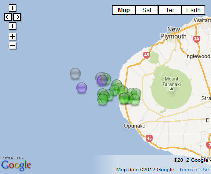
interactive map here
you may note the yellow "light" or "mag4" icons have changed to a purple colour
we had a vote over on Quake Watch 2012 and there was an overwhelming preference for the purple colour
well Olivine and I voted for the new colour, and no one else commented, so its done and dusted.
Like the elections, if you don't vote you can't complain later about the policies
the old purple "great" or "mag 9" icon is now what I call "black" but its really dark grey when the opacity is at 50%
the changes have been made right across the blog board, so all interactive maps now show 4's as purple.
new icon keys to match as well.
18 aftershocks of the 4.9 , thats quite a few, but that cape Egmont Fault Zone is pretty fragile anyway.
interactive map here
you may note the yellow "light" or "mag4" icons have changed to a purple colour
we had a vote over on Quake Watch 2012 and there was an overwhelming preference for the purple colour
well Olivine and I voted for the new colour, and no one else commented, so its done and dusted.
Like the elections, if you don't vote you can't complain later about the policies
the old purple "great" or "mag 9" icon is now what I call "black" but its really dark grey when the opacity is at 50%
the changes have been made right across the blog board, so all interactive maps now show 4's as purple.
new icon keys to match as well.
Japan daily maps from 21.12.2012 on have just been temporarily removed for editing, the location address text didn't match up with the actual
locations, I must have left out the :"where" column when I was sorting the 7 day download in Excel, so when split down into individual days later they
didn't match with the lat/long
poor quality control
the way I found out was I clicked on a 4 near Taiwan and it said NEAR CHOSHI CITY
not right of course, Choshi is in Honshu.
I'll put them back on one by one as I fix it.
poor quality control
the way I found out was I clicked on a 4 near Taiwan and it said NEAR CHOSHI CITY
not right of course, Choshi is in Honshu.
I'll put them back on one by one as I fix it.
edit on 2-1-2013 by muzzy because: (no reason given)
reply to post by muzzy
Interesting timing of the article - it's only a 4.8 but it is Nepal ! www.emsc-csem.org...
Interesting timing of the article - it's only a 4.8 but it is Nepal ! www.emsc-csem.org...
edit on 2-1-2013 by slidingdoor because: to add space
26 aftershocks now at Nay/Lourdes, Pyrenees (4,7 quake on 30/12/2012)
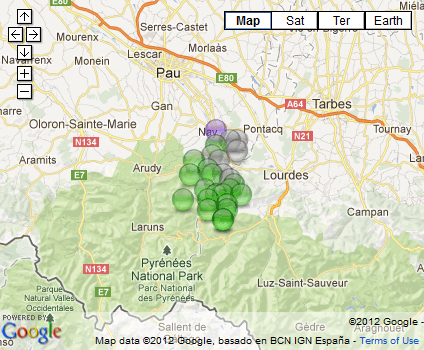
interactive version here
seem to be heading into the hills, with diminishing magnitudes
earthquakes build mountains
interactive version here
seem to be heading into the hills, with diminishing magnitudes
earthquakes build mountains
Originally posted by muzzy
26 aftershocks now at Nay/Lourdes, Pyrenees (4,7 quake on 30/12/2012)
interactive version here
seem to be heading into the hills, with diminishing magnitudes
earthquakes build mountains
I wonder if there is any old or dormant volcanoes in them there hills??
2nd.
More and more little quakes happening in this area, just south and a little east of Frisco.
earthquake.usgs.gov...
earthquake.usgs.gov...
reply to post by radpetey
Can't see any on Google Earth, but thats not to say there hasn't been any in the distant past.
A bit further east is the Garrotxa volcanic field
www.volcano.si.edu...
Can't see any on Google Earth, but thats not to say there hasn't been any in the distant past.
A bit further east is the Garrotxa volcanic field
The Olot (Garrotxa)volcanic field occupies the NE corner of Spain south of the Pyrenees Mountains about 90 km NNE of Barcelona. The Olot volcanic field consists of a large number of strombolian pyroclastic cones and associated alkali basaltic lava flows and is part of the NE Volcanic Province, which includes the Ampurdán and Selva areas to the SE. The pyroclastic cones are preferentially located at the intersection of E-W and NW-SE faults that cut sedimentary and metamorphic basement rocks. The latest dated eruption at Olot occurred during the early Holocene, and stratigraphic evidence suggests that more recent eruptions have occurred.
www.volcano.si.edu...
reply to post by muzzy
done
and I brought it to the end of 2012 while I was at it ( NIED take 3 days to review and finalize their data)
1st January should be available in about an hour in the meantime I'll bring all of December togetheron one map for the 2012/months page.
Its a big task doing Japan, so many quakes :sigh:
Japan Archives
ha! I did it within the 2 hour editing window (says 4 hours)
being conscious that when people are not logged in they can't see the links at the bottom of your signatures, and not wanting to turn this into a complete advert for my own blog, here is the Japan Map for December 2012, all 6,420 quakes recorded by NIED and reviewed for the JMA Catalog
boom
you can zoom in to see the aftershock sequence for the 7.4, but keep in mind it does have some events prior to 7/12/2012
done
and I brought it to the end of 2012 while I was at it ( NIED take 3 days to review and finalize their data)
1st January should be available in about an hour in the meantime I'll bring all of December togetheron one map for the 2012/months page.
Its a big task doing Japan, so many quakes :sigh:
Japan Archives
edit on 2-1-2013 by muzzy because: (no reason given)
ha! I did it within the 2 hour editing window (says 4 hours)
being conscious that when people are not logged in they can't see the links at the bottom of your signatures, and not wanting to turn this into a complete advert for my own blog, here is the Japan Map for December 2012, all 6,420 quakes recorded by NIED and reviewed for the JMA Catalog
boom
you can zoom in to see the aftershock sequence for the 7.4, but keep in mind it does have some events prior to 7/12/2012
edit on 2-1-2013 by muzzy because: (no reason given)
My LDEO page is back up ...................................... with a big gap between Aug 5th and
December 20th 2012.
oh well, its good to get to see those pesky Southern Ocean Pac-Ant Ridge quakes again, the ones that the main Networks seem to miss, but show on our LISS SNZO graphs as pretty decent signals.
I'll try and keep it updated.
at least I go back more than 5 days further than the actual LDEO web page does
edit on 3-1-2013 by muzzy because: (no reason given)
Originally posted by dreamfox1
Magnitude: 5.7
DateTime: Tuesday January 1 2013, 07:35:50 UTC
Region: Kuril Islands
Depth: 48.7 km
Source: USGS Feed
quakes.globalincidentmap.com...
M-type=body wave magnitude (Mb), Version=9
............. abridged
In the seemingly never ending quest to understand where they get these magnitude numbers from I had a look at what JMA had. I waited the 3 days until their"reviewed" data came out, for accuracy.
...........so the USG figures off the phase data say;
mb = 5.7 (1), ML = 5.0 (4), mblg = 4.1 (4), MS = 4.5 (1),
Mw=5.1 on the MTS page
But on the details page says mb = 5.7 (477)
(the number in brackets is the number of stations used to get that figure)
JMA say
Lat/Long: 46.977 150.655
UTC: 01/01/2013 07:35:50
JST: 01/01/2013 16:35:50
Depth: 30
Mag: 5.3 ML
Location: KURILE ISLANDS REGION
Energy Released: 1344.0280 tonnes of TNT
Source: JMA unified hypocenter catalog
01.01.2013JMA
Something else to compare with?
2013-01-01 07:35:48.3, 46.78, 151.18,, 50, 5.5mb/15stations, Kuril Islands
RAS
Trying to understand the conversion between them all if futile, I think the best solution is just to list them all and make your own judgement .
USG missed this one (doesn't show on their 4.5> list either)
LDEO has it though
that would be Ms magnitude type
can't link to AFI Samoa's LISS graph to check, its off line. I wonder if the staion got damaged in TC Evan?
LISS SNZO shows it, on this graph at the 19:50 mark
F-E Region: Samoa Islands Region
Time: 2013-01-02 19:35:16.1 UTC
Magnitude: 5.0 (mb)
Epicenter: 172.02°W 15.84°S
Depth: 10 km
Status: M - manually revised
GFZ
edit on 3-1-2013 by muzzy because: (no reason
given)
LDEO has it though
2013 1 2 19 35 12.0 -16.25 -172.25 33.0 [color=A23BEC]4.9 SAMOA ISLANDS REGION
that would be Ms magnitude type
can't link to AFI Samoa's LISS graph to check, its off line. I wonder if the staion got damaged in TC Evan?
edit on 3-1-2013 by muzzy because:
(no reason given)
LISS SNZO shows it, on this graph at the 19:50 mark
edit on 3-1-2013 by muzzy because: (no reason given)
new topics
-
President BIDEN's FBI Raided Donald Trump's Florida Home for OBAMA-NORTH KOREA Documents.
Political Conspiracies: 34 minutes ago -
Maestro Benedetto
Literature: 2 hours ago -
Is AI Better Than the Hollywood Elite?
Movies: 2 hours ago -
Las Vegas UFO Spotting Teen Traumatized by Demon Creature in Backyard
Aliens and UFOs: 5 hours ago -
2024 Pigeon Forge Rod Run - On the Strip (Video made for you)
Automotive Discussion: 6 hours ago -
Gaza Terrorists Attack US Humanitarian Pier During Construction
Middle East Issues: 6 hours ago -
The functionality of boldening and italics is clunky and no post char limit warning?
ATS Freshman's Forum: 8 hours ago -
Meadows, Giuliani Among 11 Indicted in Arizona in Latest 2020 Election Subversion Case
Mainstream News: 8 hours ago -
Massachusetts Drag Queen Leads Young Kids in Free Palestine Chant
Social Issues and Civil Unrest: 8 hours ago -
Weinstein's conviction overturned
Mainstream News: 10 hours ago
top topics
-
Krystalnacht on today's most elite Universities?
Social Issues and Civil Unrest: 11 hours ago, 9 flags -
University of Texas Instantly Shuts Down Anti Israel Protests
Education and Media: 14 hours ago, 8 flags -
Supreme Court Oral Arguments 4.25.2024 - Are PRESIDENTS IMMUNE From Later Being Prosecuted.
Above Politics: 11 hours ago, 8 flags -
Weinstein's conviction overturned
Mainstream News: 10 hours ago, 7 flags -
Gaza Terrorists Attack US Humanitarian Pier During Construction
Middle East Issues: 6 hours ago, 7 flags -
Massachusetts Drag Queen Leads Young Kids in Free Palestine Chant
Social Issues and Civil Unrest: 8 hours ago, 6 flags -
Meadows, Giuliani Among 11 Indicted in Arizona in Latest 2020 Election Subversion Case
Mainstream News: 8 hours ago, 5 flags -
Las Vegas UFO Spotting Teen Traumatized by Demon Creature in Backyard
Aliens and UFOs: 5 hours ago, 4 flags -
President BIDEN's FBI Raided Donald Trump's Florida Home for OBAMA-NORTH KOREA Documents.
Political Conspiracies: 34 minutes ago, 4 flags -
2024 Pigeon Forge Rod Run - On the Strip (Video made for you)
Automotive Discussion: 6 hours ago, 2 flags
active topics
-
University of Texas Instantly Shuts Down Anti Israel Protests
Education and Media • 237 • : cherokeetroy -
Is AI Better Than the Hollywood Elite?
Movies • 5 • : 5thHead -
New whistleblower Jason Sands speaks on Twitter Spaces last night.
Aliens and UFOs • 62 • : pianopraze -
Alternate Electors vs Fake Electors - What is the Difference.
2024 Elections • 115 • : WeMustCare -
Sunak spinning the sickness figures
Other Current Events • 24 • : NoCorruptionAllowed -
Nearly 70% Of Americans Want Talks To End War In Ukraine
Political Issues • 95 • : Irishhaf -
Meadows, Giuliani Among 11 Indicted in Arizona in Latest 2020 Election Subversion Case
Mainstream News • 14 • : WeMustCare -
HORRIBLE !! Russian Soldier Drinking Own Urine To Survive In Battle
World War Three • 44 • : theshadowknows -
President BIDEN's FBI Raided Donald Trump's Florida Home for OBAMA-NORTH KOREA Documents.
Political Conspiracies • 0 • : WeMustCare -
God's Righteousness is Greater than Our Wrath
Religion, Faith, And Theology • 31 • : glend