It looks like you're using an Ad Blocker.
Please white-list or disable AboveTopSecret.com in your ad-blocking tool.
Thank you.
Some features of ATS will be disabled while you continue to use an ad-blocker.

Tremors felt 45 miles away from Bayou Corne Sinkhole!
page: 87share:
They think it maybe stabilizing. I don't really think so but here is the article.
Full story: Stability indicators show near sinkhole
See they are optimistic, so I guess we should be also.
Scientists think a breach at a depth of 5,600 feet underground, near the bottom of the suspect cavern, has allowed sediments outside the salt dome and under intense pressures to flow into and rise up inside the 2,258-foot-tall cavity in the salt dome. This subterranean movement of earth into the cavern undermined shallower layers of rock and sediment and triggered the swampland sinkhole, now 174 feet deep, scientists have said. The flow of rock has continued, fueling growth of the sinkhole and certain types of earth tremors. Boudreaux said that cavern depth measurements going back to last fall have shown the rock had risen inside the cavern, on average, about 3 feet per day. But, on Friday, Texas Brine measured a 29-foot drop during one week. Boudreaux added that never before had the level of rock slumped inside the cavern since the sinkhole emerged. Texas Brine officials speculated Friday the drop could be an early sign that an awaited point of equilibrium is happening.
Full story: Stability indicators show near sinkhole
On the other hand... If the whole salt dome is collapsing, then another area could have opened up and the rocks in 'our' cavern would spill out into
the void just created by the collapsing or dissolving salt. That would cause a slump in the rocks due to the part lower down moving into another area
or cavern.
The rocks they talk about are the pieces of the sides of the cavern which have collapsed inwards filling up the cavern from the bottom. That is what they have been saying in the pdfs is filling up at the rate of 3 feet per day.
The point is that the water from the sinkhole must have gone somewhere (remember the floods and the water flowing into the sinkhole?) so it would make sense if this water has eaten away a channel through the salt creating voids which other parts of the dome callapse into, destabilising the whole thing. Water does not have to be hot to dissolve the salt, they only heat it so that it dissolves better I guess.
When is the next community meeting? Should be in early June I think.
From the LSU center for GeoInformatics 30 April 2013
This PDF from a RSGIS workshop on the Bayou Corne Sinkhole.
REAL-TIME SUBSIDENCE MONITORING OF THE
NAPOLEONVILLE SALT DOME SINKHOLE
USING GPS by Kent and Dunaway
Including this on Slide 11
I suppose you do not plug a well unless it is compromised or it has no more to give you.
This PDF from a RSGIS workshop on the Bayou Corne Sinkhole.
REAL-TIME SUBSIDENCE MONITORING OF THE
NAPOLEONVILLE SALT DOME SINKHOLE
USING GPS by Kent and Dunaway
Including this on Slide 11
BRIEF TIMELINE
Oxy Geismar Well No. 3 Timeline
April 1982: Oxy Geismar Well No. 3 permitted for
mining salt water brine.
1995: Texas brine received permission from Louisiana
Department of Natural Resources to store Naturally
Occurring Radioactive Material (NORM) in the well.
May 2010: DNR issues permit to mine a section of salt
above the existing cavern roof (3,400 feet deep).
June 2011: Texas Brine notifies DNR that integrity of
the well had been lost. Wellbore above the cavern
was plugged with cement
I suppose you do not plug a well unless it is compromised or it has no more to give you.
reply to post by qmantoo
"1995: Texas brine received permission from Louisiana
Department of Natural Resources to store Naturally
Occurring Radioactive Material (NORM) in the well. "
Well I'm not ashmed to say I had to look this up!
All I could think of was raw uranium.
"NORM consists primarily of material containing potassium-40 and isotopes belonging to the primordial series. The principal primordial radionuclides are isotopes of heavy elements belonging to the radioactive series headed by the three long-lived isotopes uranium-238 (uranium series), uranium-235 (actinium series), and thorium-232 (thorium series). All three of these series have numerous radionuclides in their decay chains before reaching a stable end point, lead. At background concentrations, the naturally occurring radionuclides in the uranium, actinium, and thorium series contribute about one-half of the natural background external radiation, and over 80 percent of the background including radon, to which all humans are continuously exposed.
The principal radionuclide of concern in NORM is radium-226, a member of the uranium series, which is present in natural soils in concentrations of about 1 pico Curie per gram (Ci/g). However, NORM radioisotopes may be present in different materials in varying concentrations, and some NORM wastes may have radium-226 concentrations that are much higher than 1 pCi/g, and may be as high as hundreds of thousands of pCi/g."
www.epa.gov...
So, is there anywhere where we can find out what is in that NORM and find out just what we are dealing with?
Somehow I doubt they have to register the cocktail of ingredients they place down there, and I also guess that they probably would not bother to put anything down there that was only mildy radioactive. This leads me to suspect that the NORM down under the sinkhole area is not terribly nice.
We need someone to start asking questions about it in the public meetings and to try and get some answers.
Has anyone done any radiation tests around the sinkhole to see if any of that stuff is "bubbling up". I have a feeling we should find out what is in the other caverns in case it comes up and bites us in the butt.
I can't figure out what is going on with the seismos down in Bayou Corne. CERI Bayou Corne
helicorders
Either all of the instruments experienced telemetry issues from 9-11:00 UTC, or there were 2 solid hours of lightning, or the sinkhole experience some continuous fracturing.
Here is a widened version of the LA10.YC.03.HHZ from IRIS. (this is the deepest seismo at the Oxy 3A wellpad.)
This continuous activity would have been from about 4:10 a.m. to 6:00 a.m locally--which is an abnormally early start to the workday, if it is human activity.
edit on 6/4/2013 by Olivine because: (no reason given)
edit on 6/4/2013 by Olivine because: clarification
Originally posted by Olivine
CERI Bayou Corne helicorders
....or the sinkhole experience some continuous fracturing.
It was a big slump in event, and looking at the helicorders, there was some fluid movement picked up by the two deepest instruments, LA10.03 and LA17.01.
Police Jury
On the south side of the sink hole there was an area that has subsided to include the berm. There is approximately 400 to 500 feet of the berm that is now under water. The depth to the top of the berm is 3’9″ at it’s deepest point. Also, the trees on the Southwest side are showing signs of sinking, some up to 10′ in depth.
We hope to have aerial video by the end of the day.
edit on 6/4/2013 by Olivine because: (no reason given)
edit on
6/4/2013 by Olivine because: i can't spell, or type
edit on 6/4/2013 by Olivine because: (no reason given)
This is the image from the most recent survey; well at least the bottom half of it. I couldn't make the whole thing fit.
They say the south berm is almost 4 feet under water. That berm is a long way from the edge of the sinkhole shown on this survey done on May 24th.
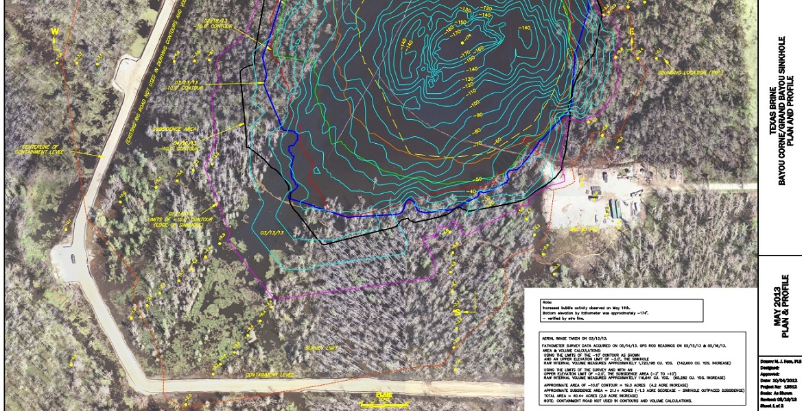
image source
edit on 6/4/2013 by Olivine
because: add an image
New article from the Advocate
I think that 29' drop in cavern height last week should have been a clue to the authorities that the situation hasn't stabilized.
What a nightmare. I wish they could send a camera down to see what is really going on.
ETA: The Assumption Parish Police Jury blog posted 2 very small photos. Not all that informative, but you can see the other end of the berm road in the distance in the 2nd photo.
Since I've ingested too much coffee, I'll just keep posting.
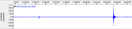
This is from LA17.01 284 meters deep (931 feet) in GEE. 200+/- microns/sec amplitude is getting pretty big.
Here is the link for the same station via CERI.
I think that 29' drop in cavern height last week should have been a clue to the authorities that the situation hasn't stabilized.
What a nightmare. I wish they could send a camera down to see what is really going on.
ETA: The Assumption Parish Police Jury blog posted 2 very small photos. Not all that informative, but you can see the other end of the berm road in the distance in the 2nd photo.
edit on 6/4/2013 by Olivine because: (no reason given)
Since I've ingested too much coffee, I'll just keep posting.
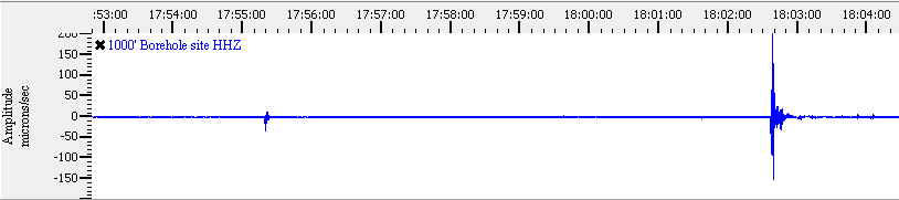
This is from LA17.01 284 meters deep (931 feet) in GEE. 200+/- microns/sec amplitude is getting pretty big.
Here is the link for the same station via CERI.
edit on
6/4/2013 by Olivine because: more info
reply to post by Olivine
Thank you for keeping watch on he instruments. The huge area of slumping is indicative of a larger collapse deeper down.
ETA
Perhaps there are more void spaces that are collapsing as more water flows down to wherever it's going?
The signaure of fluid movement is clearly noticeable on the charts you linked.
Be interesting to get spectro on that.
I don't suppose TA or Puter could find the time to pull the files and take a looksee?
edit on 4-6-2013 by jadedANDcynical because: Additional
comment
Originally posted by jadedANDcynical
reply to post by Olivine
Thank you for keeping watch on he instruments. The huge area of slumping is indicative of a larger collapse deeper down.
ETA
Perhaps there are more void spaces that are collapsing as more water flows down to wherever it's going?
It's my pleasure.
Agreed, I think the fluids down deep, maybe 6000' are under sufficient pressure to be pushed upward, creating cavities as they go.
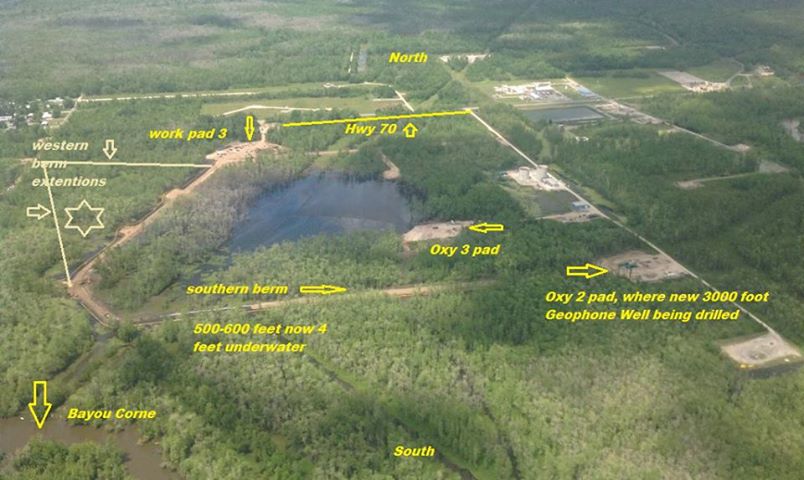
Here is a new fly-over posted 40 minutes ago on the police jury blog.
This is a screenshot from the above video, that I picked out some landmarks, for orientation.
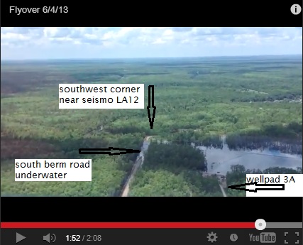
edit on 6/4/2013 by Olivine because: add a picture
Officials: Over 400 feet of berm now under water at giant Louisiana sinkhole — Trees sinking up to 10 feet deep (PHOTOS)Date: June 4, 2013
enenews.com...
enenews.com...
Some old information on radioactive NORM from last year when it surfaced in the news (Aug-Nov 2012) Some of the same stuff re-hashed by different
agencies though, but that is NORMal. I thought it was interesting how Texas Brine released and then retracted a statement about the NORM they
did/didn't place in their cavern. Then there's the wonderful quote by some guy about only being a small load of dirt with a little bit of NORM mixed
in.
22sep12
Sinkhole: Radioactivity at 5,900 picocuries per kilogram from uranium and thorium floating on surface, about double background — “Much higher levels of radiation” down deeper — Residents’ frustration growing
================================
27Nov12
People need to know if radioactive waste is coming up from the ground in area of giant sinkhole -Legal Expert
=========================================
27Nov12
Newspaper: Officials concerned about radioactive material below giant Louisiana sinkhole
==================================
Very interesting article, lots of information
30Nov12
Louisiana sinkhole radiation abuse and cover up continue
=======================================
28Nov12
Radioactive material handling probed
=================================================
11Aug12
Louisiana Sinkhole: Radioactive waste in cavern may have exceeded radiation limits — Up to 20 cubic feet pumped inside
22sep12
Sinkhole: Radioactivity at 5,900 picocuries per kilogram from uranium and thorium floating on surface, about double background — “Much higher levels of radiation” down deeper — Residents’ frustration growing
================================
27Nov12
People need to know if radioactive waste is coming up from the ground in area of giant sinkhole -Legal Expert
=========================================
27Nov12
Newspaper: Officials concerned about radioactive material below giant Louisiana sinkhole
==================================
Very interesting article, lots of information
30Nov12
Louisiana sinkhole radiation abuse and cover up continue
As early as August, a non-government group, Louisiana Environmental Action Network, began urging Bayou Corne sinkhole area residents to use a new record log. At that time, a veteran radiation expert said Louisiana environmental officials were “in denial” over hazards posed by elevated radium levels that were actually fifteen times higher than the state limit, a "worst nightmare coming true" in the sinkhole vicinity, according to environmental attorney Stuart Smith.
Stanley Waligora, a New Mexico-based radiation protection consultant and leading authority on health risks of NORM confirmed that radium levels at Bayou Corne's sinkhole are not within safe limits, but instead, roughly 15 times higher than the state's acceptable level, Smith had said.
The information about radium had been buried in a state news release, had been poorly written, and had gone "out of its way to downplay the results," Smith had said.
=======================================
28Nov12
Radioactive material handling probed
=================================================
11Aug12
Louisiana Sinkhole: Radioactive waste in cavern may have exceeded radiation limits — Up to 20 cubic feet pumped inside
Texas Brine officials said on Friday that the NORM, which had a radioactivity below current standards but matched or was higher than the standards at the time, was likely entombed at the bottom of the cavern under layers of salt after it was dumped. Brine production continued for several years afterward.
[...]
Also, on Friday, Louisiana Department of Health and Hospitals State Epidemiologist Dr. Raoult Ratard sent a letter to Assumption Parish Police Jury President Martin “Marty” Triche about potential exposure risks to the public.
The letter, state officials said, says that to date, “it does not appear that chemical exposure of site-related contaminants poses a public health risk to individuals in the immediate area of Bayou Corne for the time period and chemicals sampled.”
edit on 4 Jun 2013 by qmantoo because: typo
hello everyone.
i'm still lurking and really appreciate all the added details and info gathering ... well done folks
@ qmantoo
it's hard to accept that all of that NORMal activity was nearly a Year Ago, eh ??
i do hope ppl in the area are not holding hope for a successful resolve.
this nightmare is far from over.
prayers to those in the flooding regions and to those who can get out, don't delay.
@ cajunboy
please share just how 'woefully low' some of the original offers were.
i'm curious just how relative my earlier warnings were.
i'm still betting less than 40% of market values and if so, it should serve as a red flag for everyone ... offers that low indicate an increasing stability problem, not the opposite.
remember the first crack on the well pad ??
yeah i know y'all think i was exaggerating and maybe i was a bit, give or take 10 miles ... but, a 29ft drop in one week that is even more than i expected.
considering the Southern slump, ppl really need to be looking into the Big Hum's contributions at this point.
thanks again everyone and please, keep the pics coming ... still can't view any of the videos.
I found this very good aerial photo of the sinkhole on the Bayou Corne Sinkhole facebook
page

(click image for larger version)
This briny, hydrocarbon-filled water has reached the edge of the Bayou proper, and unfortunately, it doesn't look like the seismic activity has slowed much.
(click image for larger version)
This briny, hydrocarbon-filled water has reached the edge of the Bayou proper, and unfortunately, it doesn't look like the seismic activity has slowed much.
reply to post by Olivine
thank you for that pic ... it looks like the North region should be showing signs of bubbling and if not now, it will be soon.
no wonder they are installing tilt meters along 70
new moon this weekend and i'm guessing with the rains and current flooding/warnings, another noticeable slough-in should be expected. let's hope it is not to the North.
The best youtuber on the sinkhole is Rainbeaudais. She just put out a video. Shows good before and after.
As qmantoo said above:
Usually in the past or by coincident there would be a big rains prior to a chunk disappearing. I do wonder if this is a result of all of the prior rain. It went somewhere and it washed away something.
As qmantoo said above:
The point is that the water from the sinkhole must have gone somewhere (remember the floods and the water flowing into the sinkhole?) so it would make sense if this water has eaten away a channel through the salt creating voids which other parts of the dome collapse into, destabilizing the whole thing. Water does not have to be hot to dissolve the salt, they only heat it so that it dissolves better I guess.
Usually in the past or by coincident there would be a big rains prior to a chunk disappearing. I do wonder if this is a result of all of the prior rain. It went somewhere and it washed away something.
edit on 5-6-2013 by AuntB because: added
edit on 5-6-2013 by AuntB
because: (no reason given)
All of these changes with the flooding and the 29' drop in the cavern has me worried over this video I came across last Friday. This guy in Kenner filmed these bubbles coming up in his yard during the rain. I think his driveway or part of the road was pushed up too. He called the city to check the sewer and the gas company and got no answers, they said it could be air pushing up due to the rain. Really? I think he would have noticed before. Just makes me think that water went into the cavern and has found a way out 60miles away, gas too. This is my first time posting a video so I hope it takes. Thought it was interesting and scary!
heather
That facebook page has all the maps and pictures. It is a very good resource if you are looking for specific information.
Originally posted by Olivine
I found this very good aerial photo of the sinkhole on the Bayou Corne Sinkhole facebook page
(click image for larger version)
This briny, hydrocarbon-filled water has reached the edge of the Bayou proper, and unfortunately, it doesn't look like the seismic activity has slowed much.
...Just makes me think that water went into the cavern and has found a way out 60miles away, gas too.
Wow Heather, thats REALLY scary if that is anything gas-related, but I am not sure it could be to do with the sinkhole that far away, could it? Are there any salt domes in that area?
The Napoleonville Salt Dome diagram map I have from somewhere makes it look like it is 8 miles wide East-West and about 4 miles wide North-South with the sinkhole at the western edge.
It this gas bubbling something which is common for salt domes I wonder?
reply to post by qmantoo
Right, thought the same thing. Could it be, being that the sinkhole is that far away? With all the talk of faults and how salt caverns are thought to be all connected way underground it makes you wonder. Then the whole BP oil and GOM issue. Growing up in Houston, everyone knew that town is slowly sinking, so New Orleans I'm sure has it's issues with sinking as well. Maybe connected, maybe not, but air being pushed up due to rain water seems a little far fetched to me. I wish that guy would update, haven't checked today. Very interesting though.
heather
new topics
-
President BIDEN's FBI Raided Donald Trump's Florida Home for OBAMA-NORTH KOREA Documents.
Political Conspiracies: 2 minutes ago -
Maestro Benedetto
Literature: 1 hours ago -
Is AI Better Than the Hollywood Elite?
Movies: 1 hours ago -
Las Vegas UFO Spotting Teen Traumatized by Demon Creature in Backyard
Aliens and UFOs: 5 hours ago -
2024 Pigeon Forge Rod Run - On the Strip (Video made for you)
Automotive Discussion: 6 hours ago -
Gaza Terrorists Attack US Humanitarian Pier During Construction
Middle East Issues: 6 hours ago -
The functionality of boldening and italics is clunky and no post char limit warning?
ATS Freshman's Forum: 7 hours ago -
Meadows, Giuliani Among 11 Indicted in Arizona in Latest 2020 Election Subversion Case
Mainstream News: 8 hours ago -
Massachusetts Drag Queen Leads Young Kids in Free Palestine Chant
Social Issues and Civil Unrest: 8 hours ago -
Weinstein's conviction overturned
Mainstream News: 9 hours ago
top topics
-
Krystalnacht on today's most elite Universities?
Social Issues and Civil Unrest: 11 hours ago, 9 flags -
Supreme Court Oral Arguments 4.25.2024 - Are PRESIDENTS IMMUNE From Later Being Prosecuted.
Above Politics: 11 hours ago, 8 flags -
University of Texas Instantly Shuts Down Anti Israel Protests
Education and Media: 13 hours ago, 7 flags -
Weinstein's conviction overturned
Mainstream News: 9 hours ago, 7 flags -
Gaza Terrorists Attack US Humanitarian Pier During Construction
Middle East Issues: 6 hours ago, 7 flags -
Massachusetts Drag Queen Leads Young Kids in Free Palestine Chant
Social Issues and Civil Unrest: 8 hours ago, 6 flags -
Meadows, Giuliani Among 11 Indicted in Arizona in Latest 2020 Election Subversion Case
Mainstream News: 8 hours ago, 5 flags -
Las Vegas UFO Spotting Teen Traumatized by Demon Creature in Backyard
Aliens and UFOs: 5 hours ago, 4 flags -
2024 Pigeon Forge Rod Run - On the Strip (Video made for you)
Automotive Discussion: 6 hours ago, 2 flags -
Any one suspicious of fever promotions events, major investor Goldman Sachs card only.
The Gray Area: 16 hours ago, 2 flags
active topics
-
President BIDEN's FBI Raided Donald Trump's Florida Home for OBAMA-NORTH KOREA Documents.
Political Conspiracies • 0 • : WeMustCare -
God's Righteousness is Greater than Our Wrath
Religion, Faith, And Theology • 31 • : glend -
University of Texas Instantly Shuts Down Anti Israel Protests
Education and Media • 232 • : marg6043 -
Post A Funny (T&C Friendly) Pic Part IV: The LOL awakens!
General Chit Chat • 7135 • : underpass61 -
Nearly 70% Of Americans Want Talks To End War In Ukraine
Political Issues • 94 • : Scratchpost -
VP's Secret Service agent brawls with other agents at Andrews
Mainstream News • 62 • : ByeByeAmericanPie -
SETI chief says US has no evidence for alien technology. 'And we never have'
Aliens and UFOs • 72 • : yuppa -
My Poor Avocado Plant.
General Chit Chat • 77 • : JonnyC555 -
New whistleblower Jason Sands speaks on Twitter Spaces last night.
Aliens and UFOs • 61 • : Ophiuchus1 -
Is AI Better Than the Hollywood Elite?
Movies • 2 • : 5thHead