It looks like you're using an Ad Blocker.
Please white-list or disable AboveTopSecret.com in your ad-blocking tool.
Thank you.
Some features of ATS will be disabled while you continue to use an ad-blocker.

Huge Underwater "Roads" near Saipan on Google Earth?
page: 10
share:
I'd like to get some opinions on some pictures that were uploaded by ATS member ancientthunder on the following thread:
www.abovetopsecret.com...
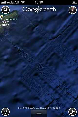
They are images taken from Google Earth in the area around Saipan that appear the show some type of large formation, perhaps roads, or something similar beneath the surface of the water. I've spent some time viewing them on Google Earth, and they are indeed there, and seem to be quite plentiful in the area.
Does anyone know what they are, or has anyone come across these "roads" before? They are rather interesting due to their size and "unnatural" look.
Special appreciation goes out to ancientthunder for a good and quite curious find.
www.abovetopsecret.com...
They are images taken from Google Earth in the area around Saipan that appear the show some type of large formation, perhaps roads, or something similar beneath the surface of the water. I've spent some time viewing them on Google Earth, and they are indeed there, and seem to be quite plentiful in the area.
Does anyone know what they are, or has anyone come across these "roads" before? They are rather interesting due to their size and "unnatural" look.
Special appreciation goes out to ancientthunder for a good and quite curious find.
edit on 20-9-2012 by isyeye because: (no reason given)
They arent roads, they are parts of the ocean that have been explored....look at the areas around the "roads", blurry, and little detail, whereas the
"roads" have lots of detail.
I would imagine its to do with areas of the ocean floor that have been mapped for various reasons. Oil, gas, minerals, ship wrecks etc etc.
Look at the first image carefully
I would imagine its to do with areas of the ocean floor that have been mapped for various reasons. Oil, gas, minerals, ship wrecks etc etc.
Look at the first image carefully
edit on 20-9-2012 by loves a conspiricy because: (no reason given)
I'm no expert...but they look like stairs to me and based on the topography of the area, seems plausible....maybe rising waters over time submerged
the area, also plausible.
Actually upon further review...the scale might not fit for stairs but maybe irrigated fields along the mountain side since submerged ?
Actually upon further review...the scale might not fit for stairs but maybe irrigated fields along the mountain side since submerged ?
edit on
20-9-2012 by Ericthenewbie because: (no reason given)
reply to post by isyeye
Roads deteriorate with time alone. Can you imagine one that's been in the ocean for thousands of years ? There would be no road. So this is impossible.
Roads deteriorate with time alone. Can you imagine one that's been in the ocean for thousands of years ? There would be no road. So this is impossible.
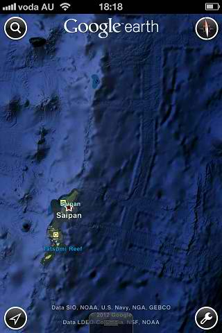
ok so I went on to G earth and looked at the "roads" then started wandering around, and to the NE of Saipan I found something interesting.
24o 17' 14" N 153o 58' 49" E there is an island. You have to zoom in pretty good for it to come up. There is an air strip and what appears to be buildings but it's greyed out almost like it is censored. Has anyone seen this and does anyone know what this island is called? It's not part of Hawaiian chain, or the bonin islands, or the saipan chain.
24o 17' 14" N 153o 58' 49" E there is an island. You have to zoom in pretty good for it to come up. There is an air strip and what appears to be buildings but it's greyed out almost like it is censored. Has anyone seen this and does anyone know what this island is called? It's not part of Hawaiian chain, or the bonin islands, or the saipan chain.
edit on 20-9-2012 by jacknast76 because: NW changed to NE
Originally posted by jacknast76
ok so I went on to G earth and looked at the "roads" then started wandering around, and to the NE of Saipan I found something interesting.
24o 17' 14" N 153o 58' 49" E there is an island. You have to zoom in pretty good for it to come up. There is an air strip and what appears to be buildings but it's greyed out almost like it is censored. Has anyone seen this and does anyone know what this island is called? It's not part of Hawaiian chain, or the bonin islands, or the saipan chain.edit on 20-9-2012 by jacknast76 because: NW changed to NE
Given how close it is to Japan, I figured it had to be involved in WWII.
West of Wake Island, but east of Guam. East of Iwo Jima, but almost as far north...
It's called Marcus Island, aka Minami-Tori-Shima.
en.wikipedia.org...
edit: and I almost forgot to mention that I found it thanks to the first map on this WWII history site:
www.ibiblio.org...
edit on 20-9-2012 by 11andrew34 because: added a source
Originally posted by randyvs
reply to post by isyeye
Roads deteriorate with time alone. Can you imagine one that's been in the ocean for thousands of years ? There would be no road. So this is impossible.
Know what I like about you Randy? You have such simple, "cut to the chase" viewpoints on so many things.
Very well stated, and very true.
Originally posted by bigfatfurrytexan
Originally posted by randyvs
reply to post by isyeye
Roads deteriorate with time alone. Can you imagine one that's been in the ocean for thousands of years ? There would be no road. So this is impossible.
Know what I like about you Randy? You have such simple, "cut to the chase" viewpoints on so many things.
Very well stated, and very true.
Except for the possibility that the "roads" in question are made of stone / rock and not current road material like concrete or asphalt. Even more so if the item is under water.
If they are from way back in the day they would be using what was available at the time, which would be rock. An item that can stand the test of time, weathering etc etc etc.
edit on 21-9-2012 by Xcathdra because: (no reason given)
reply to post by Xcathdra
Have you seen the roads laid down by the romans? They are on land, and definitely not in a condition that would be comparable to what we see in that image. Considering that these "roads" are underwater, i would expect them to be far, far more weathered.
But you may be right!
Have you seen the roads laid down by the romans? They are on land, and definitely not in a condition that would be comparable to what we see in that image. Considering that these "roads" are underwater, i would expect them to be far, far more weathered.
But you may be right!
reply to post by bigfatfurrytexan
I'm just glad to have you like something about me. That's cool.
X
Weeds and all different kind of plant life grow up thru stone rock cement driveways what have you. Again can you imagine what would grow up through the crevices of a rock road over thousands of years. There would be nothing left. I site the Bimini road before you do as it was made with boulders not just rock. I do believe it was man made but not a road.
edit on 21-9-2012 by randyvs because: (no reason given)
That is the oldest plate on Earth, Pacific Plate. It could be proof that there was alien life there on Earth long long ago in our past.
Look at how over time that island chain popped up and eroded part of those "roads".....you can see faded portions on the other side of the islands.
There is a bigger better one to see south-East of the Marianas Island chain....one MAJOR straight piece. I thought at first maybe they had ships tow a plow under the sea and buried a cable to detect submarines......but if you look closely....that's not what it is.
Why did President Bush declare that area you have pictured a "United States National Marine Park"....and we now forbid ANY country from going below the water line in that region of Earth.
en.wikipedia.org...
I met one lady who claims she's a Star Child and that there are "alienz" living down there. I don't think so myself....maybe long ago...but not now.
The answer has been given multiple times and is ignored in favor of fantastic claims with no basis. It is survey data that is applied to the map. So
basically it's areas that have been "studied" and has additional details known about it.
new topics
-
Where should Trump hold his next rally
2024 Elections: 2 hours ago -
Shocking Number of Voters are Open to Committing Election Fraud
US Political Madness: 3 hours ago -
Gov Kristi Noem Shot and Killed "Less Than Worthless Dog" and a 'Smelly Goat
2024 Elections: 3 hours ago -
Falkville Robot-Man
Aliens and UFOs: 4 hours ago -
James O’Keefe: I have evidence that exposes the CIA, and it’s on camera.
Whistle Blowers and Leaked Documents: 4 hours ago -
Australian PM says the quiet part out loud - "free speech is a threat to democratic dicourse"...?!
New World Order: 5 hours ago -
Ireland VS Globalists
Social Issues and Civil Unrest: 6 hours ago -
Biden "Happy To Debate Trump"
2024 Elections: 6 hours ago -
RAAF airbase in Roswell, New Mexico is on fire
Aliens and UFOs: 6 hours ago -
What is the white pill?
Philosophy and Metaphysics: 8 hours ago
top topics
-
A Warning to America: 25 Ways the US is Being Destroyed
New World Order: 16 hours ago, 21 flags -
Blast from the past: ATS Review Podcast, 2006: With All Three Amigos
Member PODcasts: 8 hours ago, 13 flags -
James O’Keefe: I have evidence that exposes the CIA, and it’s on camera.
Whistle Blowers and Leaked Documents: 4 hours ago, 12 flags -
Australian PM says the quiet part out loud - "free speech is a threat to democratic dicourse"...?!
New World Order: 5 hours ago, 11 flags -
Biden "Happy To Debate Trump"
2024 Elections: 6 hours ago, 10 flags -
Mike Pinder The Moody Blues R.I.P.
Music: 9 hours ago, 8 flags -
Ireland VS Globalists
Social Issues and Civil Unrest: 6 hours ago, 5 flags -
RAAF airbase in Roswell, New Mexico is on fire
Aliens and UFOs: 6 hours ago, 5 flags -
What is the white pill?
Philosophy and Metaphysics: 8 hours ago, 5 flags -
Putin, Russia and the Great Architects of the Universe
ATS Skunk Works: 12 hours ago, 4 flags
active topics
-
Gov Kristi Noem Shot and Killed "Less Than Worthless Dog" and a 'Smelly Goat
2024 Elections • 29 • : lincolnriley -
Krystalnacht on today's most elite Universities?
Social Issues and Civil Unrest • 11 • : TheWoker -
Remember These Attacks When President Trump 2.0 Retribution-Justice Commences.
2024 Elections • 59 • : TzarChasm -
Salvador Dali's Moustaches
People • 29 • : GENERAL EYES -
Mood Music Part VI
Music • 3111 • : TheWoker -
Where should Trump hold his next rally
2024 Elections • 12 • : StudioNada -
University of Texas Instantly Shuts Down Anti Israel Protests
Education and Media • 310 • : SchrodingersRat -
Candidate TRUMP Now Has Crazy Judge JUAN MERCHAN After Him - The Stormy Daniels Hush-Money Case.
Political Conspiracies • 815 • : Annee -
President BIDEN's FBI Raided Donald Trump's Florida Home for OBAMA-NORTH KOREA Documents.
Political Conspiracies • 35 • : Threadbarer -
2024 Pigeon Forge Rod Run - On the Strip (Video made for you)
Automotive Discussion • 8 • : WhitewaterSquirrel
0