It looks like you're using an Ad Blocker.
Please white-list or disable AboveTopSecret.com in your ad-blocking tool.
Thank you.
Some features of ATS will be disabled while you continue to use an ad-blocker.

The Mysteries of Cumbe Mayo
page: 110
share:
In the Cajamarca Region of Peru, there is a mysterious place named Cumbre Mayo that was inhabited by the pre-Inca Caxamarca Culture. While they
reached their peak between 500 and 1000 AD, the roots of this ancient civilization may go back to at least 1500 BC, and may have still have been
around as late as 1450 AD co-existing with the Inca. Cumbre Mayo is filled will undecyphered petraglyphs, incredible aqueducts, stone forest, and
caves. It is an often overlooked and understudied archeological site that deserves much more attention than it recieves.
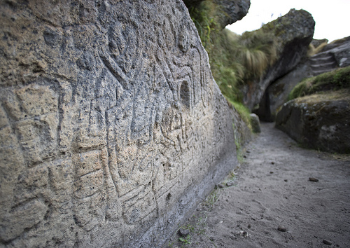
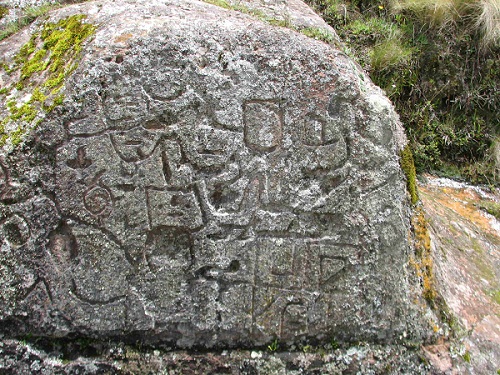
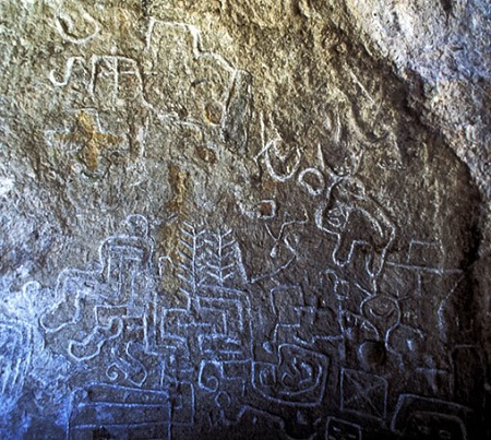
Some of the petraglyphs found at Cumbe Mayo
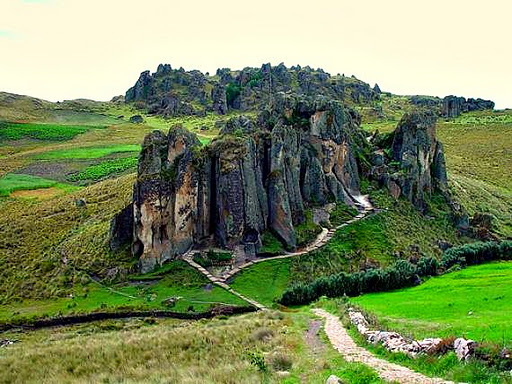
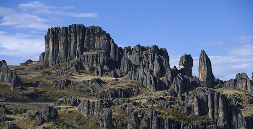
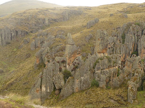
The Stone Forest (Los Frailones, or the Stone Monks)
www.go2peru.com...
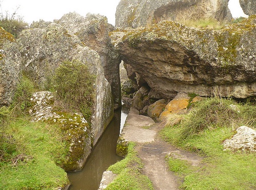
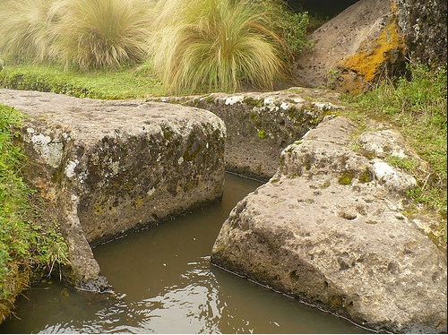
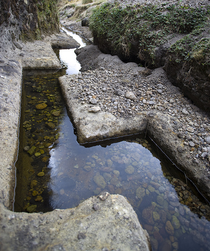
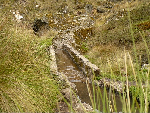
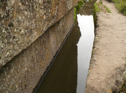
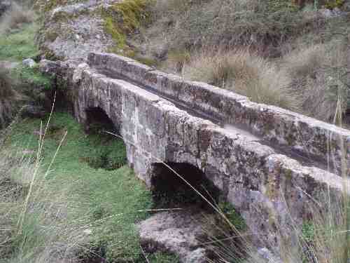
The Cumbe Mayo Aqueducts
en.wikipedia.org...
Archeological sites such as Cumbe Mayo leave me in awe. The undecyphered petraglyphs are particularly interesting. Some believe that the petraglyphs may be a map to navigate the stone forest, but noone appears to really know for sure. The Caxamarca Culture and Cumbre Mayo are parts of our history, that is sadly not explored as much as it should be.
The Cajamarca Region of Peru holds many beautiful sites, and some that I'm sure that have yet to be discovered. Unfortunately, there is very little mention of some of it's wonders from reputable sources. Most of what I have been able to find out about it has been thru tourist websites. Cumbre Mayo is a site that needs much more exploration.
This has been a rather hard thread to put together because there is so much conflicting information about Cumbre Mayo. It seems that nearly every website list different lengths of the aqueducts, and different timeframes for the Caxamarca Culture. While I've tried to be as factual as possible in this thread, exact dates and facts may not be completely accurate due to such a wide variety of information. This is one of the important reasons for further research.
www.unpavedsouthamerica.com...
www.jpereyra.com...
www.pbase.com...
en.wikipedia.org...
thebackpackershandbook.com...
www.go2peru.com...
www.perucontact.com...
www.travelblog.org...
enperublog.com...
Some of the petraglyphs found at Cumbe Mayo
Caxamarca Culture
Pre-Inca culture (500-1000 AD) that corresponds to the late intermediate period, settled down in the north andean part on the department of Cajamarca, their domain reached to the departments of Amazonas and La Libertad.
Remarkable megalithic constructions among those outstanding Cumbe Mayo (the biggest megalithic construction in America and the maximum expression of hydraulic engineering), besides Collos, the necropolis of Otuzco, Kuntur Wasi's temples and Rumi Tiana among others.
It reached a high development in the textile art; their ceramic highlights because of its fineness, the characteristic shapes are plates tripods or with pedestal base, recipients with the shape of a lentil, glasses and tablespoons; the pieces were elaborated with clay and kaolin and they have very thin walls, worked by hand, without molds and cooked in open oven. They decorated their pots in its exterior and interior, with fine lines in ocher, red or black on a beige base.
It was an organized and warrior town; they were subjected to the Tahuantisuyo after bloody battles with the Inca Pachacútec who ordered to build a temple to the God Inti and an acllahuasi (Quechua language) after taking the city of Cajamarca.
The Stone Forest (Los Frailones, or the Stone Monks)
www.go2peru.com...
Cumbe Mayo (in Quechua language that means fine river)
Located 21 km (13 miles) south west of Cajamarca, the highway that leads to it is half asphalted and the other half is not.
This archaeological deposit belongs to the Caxamarca culture (XI Century), the biggest megalithic construction in America, covers an area of 25,000 sq/mt. There exist a fortress, sanctuaries and caves with stone carvings.
Outstanding the water channels, considered as the maximum expression in hydraulic engineering. The aqueduct is channel finely carved in rock, with more than 1 km (0.62 miles) length and 1.5 m. (4.92 feet) gradient, traced forming borders and straight angles to control flow speed, avoiding the water to return and also the erosion.
The Cumbe Mayo Aqueducts
en.wikipedia.org...
Cumbe Mayo is located about 12 miles (19 km) southwest of the Peruvian city of Cajamarca, at an elevation of approximately 11,000 feet (3,300 meters). The location is best known for the ruins of a Pre-Incan aqueduct stretching approximately five miles in length. The aqueduct collected water from the Atlantic watershed and redirected it on its way to the Pacific Ocean. It is thought to have been constructed around 1500 B.C. and was once thought to be the oldest existing man-made structure in South America. The name Cumbe Mayo may be derived from a Quechua phrase, kumpi mayu, meaning “well-made water channel,” or humpi mayo, meaning “thin river.”
There are a number of petroglyphs on the aqueduct and surrounding caverns.
This remote mountainous region is also the location of a "stone forest" composed of natural volcanic rocks which have been shaped by erosion. These formations of volcanic rock are also known as Los Frailones, or the Stone Monks
Archeological sites such as Cumbe Mayo leave me in awe. The undecyphered petraglyphs are particularly interesting. Some believe that the petraglyphs may be a map to navigate the stone forest, but noone appears to really know for sure. The Caxamarca Culture and Cumbre Mayo are parts of our history, that is sadly not explored as much as it should be.
The Cajamarca Region of Peru holds many beautiful sites, and some that I'm sure that have yet to be discovered. Unfortunately, there is very little mention of some of it's wonders from reputable sources. Most of what I have been able to find out about it has been thru tourist websites. Cumbre Mayo is a site that needs much more exploration.
This has been a rather hard thread to put together because there is so much conflicting information about Cumbre Mayo. It seems that nearly every website list different lengths of the aqueducts, and different timeframes for the Caxamarca Culture. While I've tried to be as factual as possible in this thread, exact dates and facts may not be completely accurate due to such a wide variety of information. This is one of the important reasons for further research.
www.unpavedsouthamerica.com...
www.jpereyra.com...
www.pbase.com...
en.wikipedia.org...
thebackpackershandbook.com...
www.go2peru.com...
www.perucontact.com...
www.travelblog.org...
enperublog.com...
edit on 9-2-2012 by isyeye because: (no reason given)
this is cool, ive been doing alot of research on Peru and Bolivia lately and i didnt not come across any information about this place whats so ever.
Im planning a trip there the at end of the year and these places will definitively be part of my visits while in Peru.
Good discovery!
Im planning a trip there the at end of the year and these places will definitively be part of my visits while in Peru.
Good discovery!
reply to post by Eniii
If you do visit Cumbe Mayo, be sure to take as many pictures of the petraglyphs as possible. There are VERY few available on the internet. Additional pictures of the petraglyphs would be a huge addition to this thread, and to the knowledge of Cumbe Mayo and the Caxamarca Culture.
I'm also a bit jealous of your travel plans.
edit on 9-2-2012 by isyeye because: (no reason given)
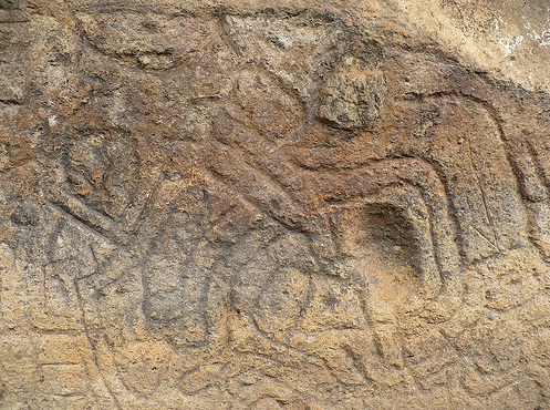
I found one more picture of the petraglyphs at Cumbe Mayo.
edit on 9-2-2012 by isyeye because: (no reason given)
new topics
-
A Warning to America: 25 Ways the US is Being Destroyed
New World Order: 3 hours ago -
President BIDEN's FBI Raided Donald Trump's Florida Home for OBAMA-NORTH KOREA Documents.
Political Conspiracies: 9 hours ago -
Maestro Benedetto
Literature: 11 hours ago -
Is AI Better Than the Hollywood Elite?
Movies: 11 hours ago
top topics
-
President BIDEN's FBI Raided Donald Trump's Florida Home for OBAMA-NORTH KOREA Documents.
Political Conspiracies: 9 hours ago, 28 flags -
Gaza Terrorists Attack US Humanitarian Pier During Construction
Middle East Issues: 16 hours ago, 8 flags -
Massachusetts Drag Queen Leads Young Kids in Free Palestine Chant
Social Issues and Civil Unrest: 17 hours ago, 7 flags -
A Warning to America: 25 Ways the US is Being Destroyed
New World Order: 3 hours ago, 7 flags -
Las Vegas UFO Spotting Teen Traumatized by Demon Creature in Backyard
Aliens and UFOs: 14 hours ago, 6 flags -
Meadows, Giuliani Among 11 Indicted in Arizona in Latest 2020 Election Subversion Case
Mainstream News: 17 hours ago, 5 flags -
2024 Pigeon Forge Rod Run - On the Strip (Video made for you)
Automotive Discussion: 15 hours ago, 4 flags -
Is AI Better Than the Hollywood Elite?
Movies: 11 hours ago, 3 flags -
The functionality of boldening and italics is clunky and no post char limit warning?
ATS Freshman's Forum: 17 hours ago, 1 flags -
Maestro Benedetto
Literature: 11 hours ago, 1 flags
10