It looks like you're using an Ad Blocker.
Please white-list or disable AboveTopSecret.com in your ad-blocking tool.
Thank you.
Some features of ATS will be disabled while you continue to use an ad-blocker.

Armstrong Explains How To Fake A Trip To The Moon
page: 16
share:
Step one:
Step two:
Step three:
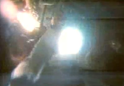
But don’t forget to turn off the camera after you are done! Otherwise you might let the public see the low intensity work lights inside the cabin, leading to an image that looks like this:

And whatever you do, make sure your camera is off before re-adjusting the iris back to its normal setting.
To hear Armstrong speaking about the trickery himself, see this video:
For those of you who doubt our own criminal government would stoop to such a level, I would point you to:
Of course, there is far more evidence that shows the entire thing was a gigantic hoax if one should chose to look for it. This video just happens to be the most definitive proof I’ve seen so far.
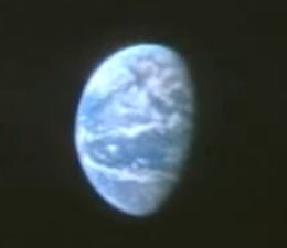
For those of you who are curious, this is what Earth really looks like from the vantage point of the moon. This sequence of images was taken by the Japanese KAGUYA satellite. Notice you can see the polar icecaps quite clearly in the image. Compare that image with this image which was taken on Dec 24th 1968, supposedly from Apollo 8.
In the Apollo image, the Earth is a sky blue while giving off a reflected light flare from the ocean surface, no ice caps are prominent in the image. In the KAGUYA image, the oceans are a deep blue that do not reflect much light at all. Further, I challenge anyone to line up the coast line visible in the Apollo image with a globe of the Earth and show me what monstrous continent that coast line represents.
And just in case someone wants to claim that coast line is Africa, I don’t think so:

This is an overlay conducted using Google Earth with the image of Earth from the Apollo photo. Obviously the Earth in the Apollo photo isn’t even round, it is oblong (because the window frame creates that illusion.) Further, the African content doesn’t line up at all with the image. The blue lines represent the edge of the Apollo landmass. The real Africa is hidden in the shadows.
I’m confident that an analysis of the Earth’s position during the period that photo was supposedly taken and the position of the camera will result in an impossible mismatch between what the photo should have shown the Earth to look like and what the photo actually looks like.
- Get a crescent shaped cardboard cutout.
Step two:
- Launch yourself into low Earth orbit in a spacecraft that has round windows.
Step three:
- Hold cardboard cutout to window and turn down the iris of the camera to black out surrounding spacecraft interior.
This will create an image that looks like this (notice the Earth is one gigantic landmass):
But don’t forget to turn off the camera after you are done! Otherwise you might let the public see the low intensity work lights inside the cabin, leading to an image that looks like this:
And whatever you do, make sure your camera is off before re-adjusting the iris back to its normal setting.
To hear Armstrong speaking about the trickery himself, see this video:
For those of you who doubt our own criminal government would stoop to such a level, I would point you to:
- The Gulf of Tonkin
- The USS Liberty attack
- Iran Contra Affair
- Iraqi WMDs
- The 1953 Iranian Coup D’état
- Japanese American internment
- Jim Crow and Slavery Laws
- etc.. etc.. etc..
Of course, there is far more evidence that shows the entire thing was a gigantic hoax if one should chose to look for it. This video just happens to be the most definitive proof I’ve seen so far.
For those of you who are curious, this is what Earth really looks like from the vantage point of the moon. This sequence of images was taken by the Japanese KAGUYA satellite. Notice you can see the polar icecaps quite clearly in the image. Compare that image with this image which was taken on Dec 24th 1968, supposedly from Apollo 8.
In the Apollo image, the Earth is a sky blue while giving off a reflected light flare from the ocean surface, no ice caps are prominent in the image. In the KAGUYA image, the oceans are a deep blue that do not reflect much light at all. Further, I challenge anyone to line up the coast line visible in the Apollo image with a globe of the Earth and show me what monstrous continent that coast line represents.
And just in case someone wants to claim that coast line is Africa, I don’t think so:
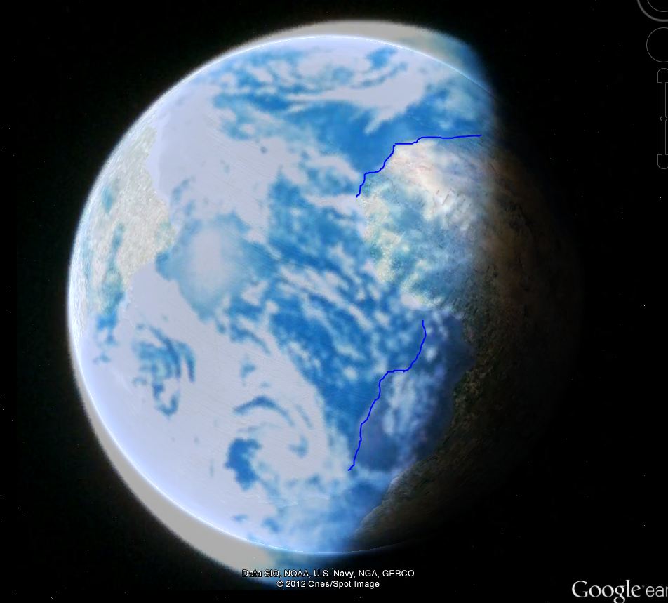
This is an overlay conducted using Google Earth with the image of Earth from the Apollo photo. Obviously the Earth in the Apollo photo isn’t even round, it is oblong (because the window frame creates that illusion.) Further, the African content doesn’t line up at all with the image. The blue lines represent the edge of the Apollo landmass. The real Africa is hidden in the shadows.
I’m confident that an analysis of the Earth’s position during the period that photo was supposedly taken and the position of the camera will result in an impossible mismatch between what the photo should have shown the Earth to look like and what the photo actually looks like.
edit on 11-1-2012 by mnemeth1 because: (no reason given)
I want to hear him explain how a flag was blowing in space where there is appearently no air. Unless they never went in the first place.
I have a couple questions: has any other nation ever claimed to have physically been on the moon? and why would we lie about this/what was to
gain?...also do you believe we were warned away? I'm curious as to your stance on these things
Course they went to the moon !
They gave the Netherlands PM a piece of dead tree to prove it !
They gave the Netherlands PM a piece of dead tree to prove it !
I want to hear how the Russians could have taken soil samples that were virtually identical to the soil samples Apollo 12 took, if the American moon
landings were fake.
Originally posted by Chadwickus
I want to hear how the Russians could have taken soil samples that were virtually identical to the soil samples Apollo 12 took, if the American moon landings were fake.
collusion? I don't know.
What I do know is that image of the Earth from the Apollo photos is fake.
Again???
This was so yesterday!
Its been done over so many times on here, why even bother anymore? If people don't want to believe, they never will. Just, dont watch too many "doc...I mean "mockumentaries"
This was so yesterday!
Its been done over so many times on here, why even bother anymore? If people don't want to believe, they never will. Just, dont watch too many "doc...I mean "mockumentaries"
I would think it was done for funding for other projects I mean we were racing to be there first and with the faking of it they could keep all the
money meant for the mission and once it was faked then tons of money would flow in no questions asked, so that's my opinion I cld be way off but who
knows it wld just seem the best reason to me
reply to post by mnemeth1
What confuses me about your post is that a satellite www.thefreedictionary.com... is on the moon. By very definition that is impossible.
Likewise said satellite has the exact same image 5 times with only position being different as it is "rising?"
Our earth rotates on it's own at the rate of once every 24 hours (give or take) So even over a short time of (for instance) a 10 minute earth rise the image and cloud coverage should change.
More on topic how many years apart were the Apollo 8 and the Japanese "satellite" photos? Image recording has upped itself greatly in the last 20 years. I can see, with no conspiracy, how 2 photos taken 20 years apart (or longer) could have much different resolution as well as composition.
Wow, another "Try-Hard" clones a thread.
Another grab for stars and flags?
Another grab for stars and flags?
I used to think the moon was a fake, but now I think the fake is a fake. Let me explain.
If a fast moving, social internet society was onto you about all the secrets you are hiding, what better plan than to get them thinking you never went to the moon in the first place?
What genius. The government says: "In reality, we have bases on the moon and on mars, but these dummies will think we haven't even landed on the moon." "Oh how the conspiracy junkies will love this one and we'll totally throw them off."
Don't believe it, just think about it.
Please direct your comments to this ongoing Thread
Fake Earth illusion - footage from Apollo 11, 1969
Thanks
- closed -
Fake Earth illusion - footage from Apollo 11, 1969
Thanks
- closed -
new topics
-
Big Storms
Fragile Earth: 42 minutes ago -
Where should Trump hold his next rally
2024 Elections: 3 hours ago -
Shocking Number of Voters are Open to Committing Election Fraud
US Political Madness: 4 hours ago -
Gov Kristi Noem Shot and Killed "Less Than Worthless Dog" and a 'Smelly Goat
2024 Elections: 4 hours ago -
Falkville Robot-Man
Aliens and UFOs: 5 hours ago -
James O’Keefe: I have evidence that exposes the CIA, and it’s on camera.
Whistle Blowers and Leaked Documents: 5 hours ago -
Australian PM says the quiet part out loud - "free speech is a threat to democratic dicourse"...?!
New World Order: 6 hours ago -
Ireland VS Globalists
Social Issues and Civil Unrest: 7 hours ago -
Biden "Happy To Debate Trump"
2024 Elections: 7 hours ago -
RAAF airbase in Roswell, New Mexico is on fire
Aliens and UFOs: 7 hours ago
top topics
-
A Warning to America: 25 Ways the US is Being Destroyed
New World Order: 17 hours ago, 21 flags -
Blast from the past: ATS Review Podcast, 2006: With All Three Amigos
Member PODcasts: 9 hours ago, 13 flags -
James O’Keefe: I have evidence that exposes the CIA, and it’s on camera.
Whistle Blowers and Leaked Documents: 5 hours ago, 12 flags -
Biden "Happy To Debate Trump"
2024 Elections: 7 hours ago, 12 flags -
Australian PM says the quiet part out loud - "free speech is a threat to democratic dicourse"...?!
New World Order: 6 hours ago, 12 flags -
Mike Pinder The Moody Blues R.I.P.
Music: 10 hours ago, 8 flags -
What is the white pill?
Philosophy and Metaphysics: 9 hours ago, 6 flags -
Shocking Number of Voters are Open to Committing Election Fraud
US Political Madness: 4 hours ago, 5 flags -
Ireland VS Globalists
Social Issues and Civil Unrest: 7 hours ago, 5 flags -
RAAF airbase in Roswell, New Mexico is on fire
Aliens and UFOs: 7 hours ago, 5 flags
active topics
-
I am beholden to my truth, of which I share with you now.
Dreams & Predictions • 24 • : BrotherKinsMan -
Big Storms
Fragile Earth • 6 • : lilzazz -
Gov Kristi Noem Shot and Killed "Less Than Worthless Dog" and a 'Smelly Goat
2024 Elections • 32 • : RazorV66 -
Starburst galaxy M82 - Webb Vs Hubble
Space Exploration • 11 • : Arbitrageur -
"We're All Hamas" Heard at Columbia University Protests
Social Issues and Civil Unrest • 291 • : marg6043 -
Candidate TRUMP Now Has Crazy Judge JUAN MERCHAN After Him - The Stormy Daniels Hush-Money Case.
Political Conspiracies • 817 • : RazorV66 -
Post A Funny (T&C Friendly) Pic Part IV: The LOL awakens!
General Chit Chat • 7137 • : PorkChop96 -
Massachusetts Drag Queen Leads Young Kids in Free Palestine Chant
Social Issues and Civil Unrest • 21 • : ToneD -
Biden "Happy To Debate Trump"
2024 Elections • 49 • : TheMisguidedAngel -
Where should Trump hold his next rally
2024 Elections • 13 • : Edumakated
6