It looks like you're using an Ad Blocker.
Please white-list or disable AboveTopSecret.com in your ad-blocking tool.
Thank you.
Some features of ATS will be disabled while you continue to use an ad-blocker.

Europe and US Be Aware - Winter Is Returning...
page: 1share:
What I’m about to present to you may very well put my reputation on the line with regards to weather forecasting and preparedness, however, with
recent threads being created regarding the recent mild weather and the lack of cold…it’s justifiable to warn of a potential set-up that merits
recognition in both the United States and Europe.
We have all felt the milder weather, and here we are in Early January with no mention of snow or cold from any major weather sources. There is little to go on really except for folk-lore and speculation. Neither of which benefit us in reality when it comes to the harshness that winter can provide – especially those in the United States and Canada.
So why the hush in the media?
Well, this I can only presume is because of the uncertainty…there is only one certainty at this moment and that certainty is that there is a general pattern change occurring in the Northern Hemisphere at the moment, what that brings for specifics is open to debate which is where I am putting my reputation on the line. I am going to try and give some specifics.
The current set up in Europe
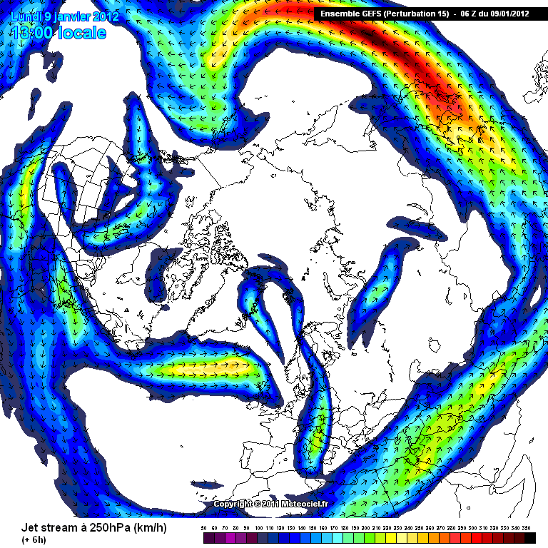
At present we can see from the below picture that the Jet Stream is blowing straight into the UK from a maritime origin. This is driving the extra tropical cyclones into the UK (remember the storms), which then transits through to Europe. Europe is lacking any real cold just now because of the placement of the Jet Stream. The Jet Stream is amplified because of the extreme cold of the Stratosphere.
The current set up in North America
At the moment (and has been for a while) the US is locked in the grip of continual High Pressure systems. This is feeding in air from a milder origin to the south. This has kept temperatures during the day quite mild, as here in Europe. Of course there are areas to the exception but they really need some kind of elevation. At present, as seen below there is very little in the way of a Jet Stream over the US and Canada. This is preventing much in the way of change here and unless this “sorts itself out” we will see the milder weather continue…
So where is the potential?
OK, this is where it gets to the nitty gritty. The Northern Hemisphere is displaying subtle changes, that, when analysed can paint a picture…that picture isn’t exactly clear yet but it is confirming a change. How bad is that change, well it is still open for clarification but I am willing at this point to give you my thoughts and expectations using my interpretation of the model outputs. Why? Well I see a change, I believe the change will come and I believe it will catch many off guard. I also want to put to bed any threads that cause confusion and spread dis-information about why we are experiencing what we are…and where winter has gone!
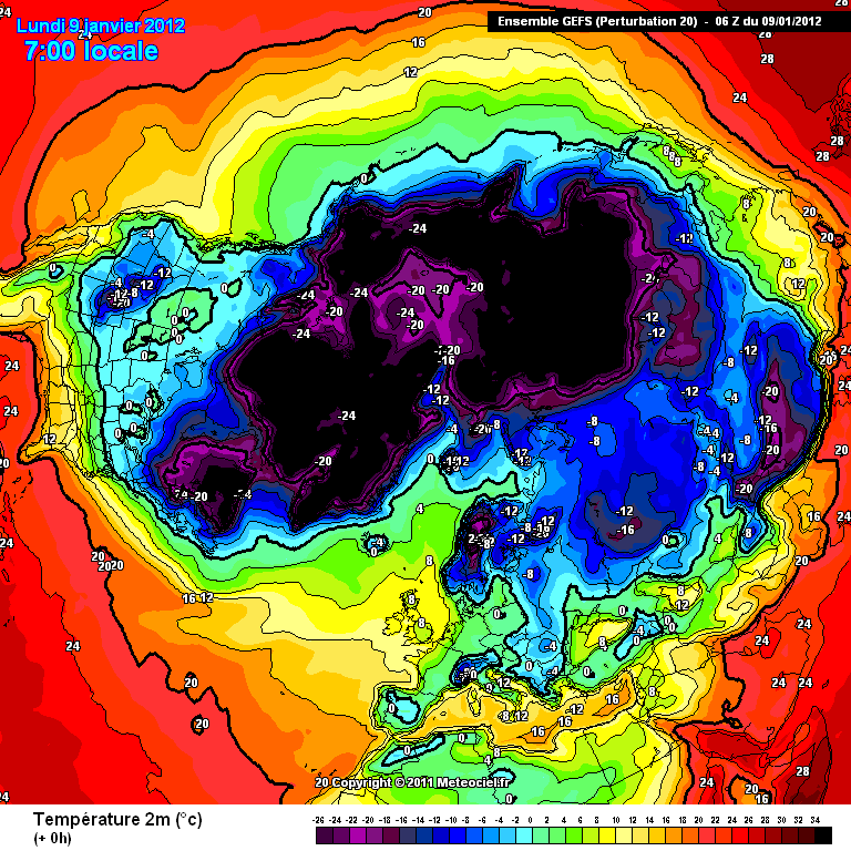
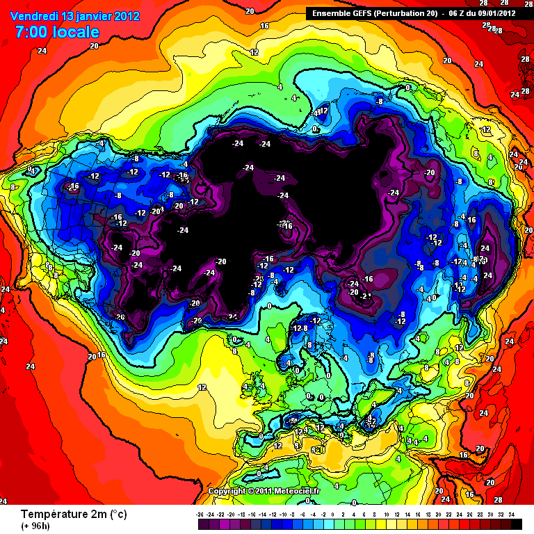
The image below shows you temperatures for today at a height of 2 meters above the ground. As you can see, the UK is quite tropical sitting at around 8 Celsius, with a large portion of the US and Canada sitting at around 0-10celcius, which is quite balmy for that neck of the woods.
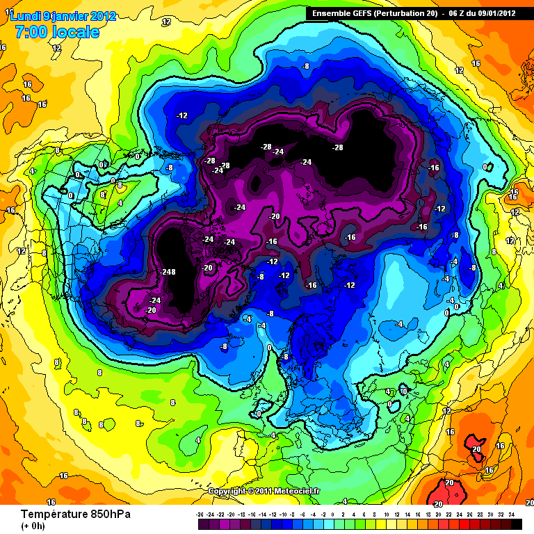
Below you can see the temperature of the air masses currently located around the Northern Hemisphere. These temperatures are taken at a height of around 1,500m above sea level. So as you can see, its actually quite mild around Europe and North America...not good for snow lovers. The main exception being over Greenland - which is the Polar Vortex, that's causing us to have to put up with this autumnal weather.
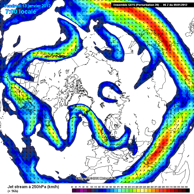
Here, below, we can see the shift taking place. As you will note the Jet Stream is shifting in both the US and Europe. This is valid for the 13th January. This is allowing a colder pool of air to emerge into both the Central US states and Europe.
Here we have the corresponding 2 meter image for the 13th January. As you can see, with the Jet shifting, it is allowing temperatures in the US to plummet, and its causing the temperature of Europe to drop away as well. The UK will be between 0-4 Celsius, while the mid states will be ranging from -16 to 0 Celsius. Not pretty weather,
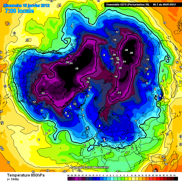
Here you can see the air masses for the Northern Hemisphere around the 15th January. A stark change to today. At a height of 1,500m, we are seeing temperatures over the UK at around -4 and the US and Canada, anywhere between -24 to -4 Celsius. This means, if there is precipitation, it'll most likely be snow...
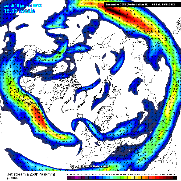
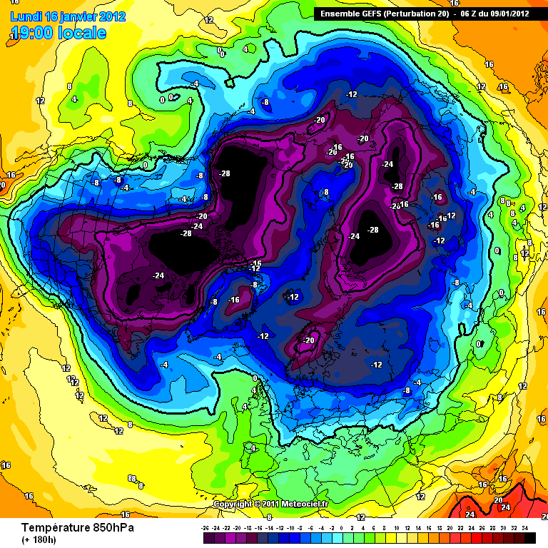
Here we have the Jet Stream at around +180hours out, roughly the 16th of January. Below this image are the 2 corresponding images for the 2 meter height and the 1,500m height.
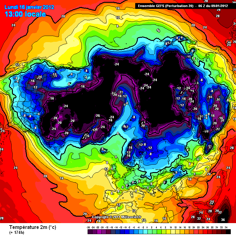
Here is the 2 meter temperature for the Northern Hemisphere. The US will be in a grip of cold air, with the UK still below average.
Here is the 1,500m height, as you can see, the cold air really digs in through the mid US. Potentially very cold weather indeed.
Conclusion
What we are seeing here is a change in the dynamics of the weather pattern across the Northern Hemisphere. The set up that has brought us this milder weather is shifting and its becoming more favourable for cold lovers. The US could be particularly hard hit around the area's below from around the beginning to middle of next week onwards. The UK, by standards of late will also experience a bite, that will come as a shock to most. There is also the potential for Europe to be in a bit of a freeze later on, around the 20th January, which, if all other ingredients fall into place (speculation at present) could lead to a sustained colder period for the UK around the 20th-25th January.
My advice here would be to prepare for cold, if it materialises (dependent on severity) at least you are ready. There is no harm or fear mongering intended here. This is a legitimate forecast for potentially very wintry weather for the US and the UK/Europe. Take the advice or leave it...time will tell
I will provide a further update at the weekend, where the output signals can be more closely verified or disregarded.
P.S. Keep your eyes and ear's open for MSM forecasts, as of yet i believe they haven't released anything i suspect they are waiting to see what is in the wings...
We have all felt the milder weather, and here we are in Early January with no mention of snow or cold from any major weather sources. There is little to go on really except for folk-lore and speculation. Neither of which benefit us in reality when it comes to the harshness that winter can provide – especially those in the United States and Canada.
So why the hush in the media?
Well, this I can only presume is because of the uncertainty…there is only one certainty at this moment and that certainty is that there is a general pattern change occurring in the Northern Hemisphere at the moment, what that brings for specifics is open to debate which is where I am putting my reputation on the line. I am going to try and give some specifics.
The current set up in Europe
At present we can see from the below picture that the Jet Stream is blowing straight into the UK from a maritime origin. This is driving the extra tropical cyclones into the UK (remember the storms), which then transits through to Europe. Europe is lacking any real cold just now because of the placement of the Jet Stream. The Jet Stream is amplified because of the extreme cold of the Stratosphere.
The current set up in North America
At the moment (and has been for a while) the US is locked in the grip of continual High Pressure systems. This is feeding in air from a milder origin to the south. This has kept temperatures during the day quite mild, as here in Europe. Of course there are areas to the exception but they really need some kind of elevation. At present, as seen below there is very little in the way of a Jet Stream over the US and Canada. This is preventing much in the way of change here and unless this “sorts itself out” we will see the milder weather continue…
So where is the potential?
OK, this is where it gets to the nitty gritty. The Northern Hemisphere is displaying subtle changes, that, when analysed can paint a picture…that picture isn’t exactly clear yet but it is confirming a change. How bad is that change, well it is still open for clarification but I am willing at this point to give you my thoughts and expectations using my interpretation of the model outputs. Why? Well I see a change, I believe the change will come and I believe it will catch many off guard. I also want to put to bed any threads that cause confusion and spread dis-information about why we are experiencing what we are…and where winter has gone!
The image below shows you temperatures for today at a height of 2 meters above the ground. As you can see, the UK is quite tropical sitting at around 8 Celsius, with a large portion of the US and Canada sitting at around 0-10celcius, which is quite balmy for that neck of the woods.
Below you can see the temperature of the air masses currently located around the Northern Hemisphere. These temperatures are taken at a height of around 1,500m above sea level. So as you can see, its actually quite mild around Europe and North America...not good for snow lovers. The main exception being over Greenland - which is the Polar Vortex, that's causing us to have to put up with this autumnal weather.
Here, below, we can see the shift taking place. As you will note the Jet Stream is shifting in both the US and Europe. This is valid for the 13th January. This is allowing a colder pool of air to emerge into both the Central US states and Europe.
Here we have the corresponding 2 meter image for the 13th January. As you can see, with the Jet shifting, it is allowing temperatures in the US to plummet, and its causing the temperature of Europe to drop away as well. The UK will be between 0-4 Celsius, while the mid states will be ranging from -16 to 0 Celsius. Not pretty weather,
Here you can see the air masses for the Northern Hemisphere around the 15th January. A stark change to today. At a height of 1,500m, we are seeing temperatures over the UK at around -4 and the US and Canada, anywhere between -24 to -4 Celsius. This means, if there is precipitation, it'll most likely be snow...
Here we have the Jet Stream at around +180hours out, roughly the 16th of January. Below this image are the 2 corresponding images for the 2 meter height and the 1,500m height.
Here is the 2 meter temperature for the Northern Hemisphere. The US will be in a grip of cold air, with the UK still below average.
Here is the 1,500m height, as you can see, the cold air really digs in through the mid US. Potentially very cold weather indeed.
Conclusion
What we are seeing here is a change in the dynamics of the weather pattern across the Northern Hemisphere. The set up that has brought us this milder weather is shifting and its becoming more favourable for cold lovers. The US could be particularly hard hit around the area's below from around the beginning to middle of next week onwards. The UK, by standards of late will also experience a bite, that will come as a shock to most. There is also the potential for Europe to be in a bit of a freeze later on, around the 20th January, which, if all other ingredients fall into place (speculation at present) could lead to a sustained colder period for the UK around the 20th-25th January.
My advice here would be to prepare for cold, if it materialises (dependent on severity) at least you are ready. There is no harm or fear mongering intended here. This is a legitimate forecast for potentially very wintry weather for the US and the UK/Europe. Take the advice or leave it...time will tell
I will provide a further update at the weekend, where the output signals can be more closely verified or disregarded.
P.S. Keep your eyes and ear's open for MSM forecasts, as of yet i believe they haven't released anything i suspect they are waiting to see what is in the wings...
wow...haven't even been able to chew through all of this yet...just want to say thanks mate! S&F!
love the work you put into this! definitely be keeping an eye on this to watch for future info! thanks for all the work!
love the work you put into this! definitely be keeping an eye on this to watch for future info! thanks for all the work!
very useful information thanks
will see how it pans out here in yorkshire
will see how it pans out here in yorkshire
we have our own ats weather man haha.
s+f
i hope your right because this lack of snow is starting to bother me
s+f
i hope your right because this lack of snow is starting to bother me
reply to post by jrmcleod
Thanks jrmcleod for this well build set of information.
I do hope you are wrong in this prediction.
I hate cold winters, I was born in the tropics, maybe that explains that.
Maybe to be on the safe side we should all be driving around useless trips in our cars?
Kidding.
I do hope no one gets hurt in this cold, at least no more then normal.
Thanks for the info fella.
Have enjoyed the last few weather threads and whether (pardon the pun) the info is correct or not, I am at least learning something about reading the charts
Have enjoyed the last few weather threads and whether (pardon the pun) the info is correct or not, I am at least learning something about reading the charts
s&f for you my friend will look forward to reading in more detail after work
Here in AZ my rosemary has flowers on it, my ornamental grass has plumes and my dog is dropping his winter coat already! We had one month of winter
after a horrible summer. I SURE HOPE it gets cold again because this has had me very worried. Never seen anything like this.
Very nice post...
Thanks for the effort and the heads up
Thanks for the effort and the heads up
edit on 9-1-2012 by drneville because: (no reason given)
edit on 9-1-2012 by
drneville because: (no reason given)
Great thread..
I'm a bit of a weather watcher myself, but I'm more inclined to watch the weather out of my window and speculate on it all after observations over a period of time.
I feel we are guaranteed a real hard time this year with the cold weather sneaking up on us to hit us with a real big surprise.
We've had a few small tasters here in the UK.. a bit of snow a few weeks ago, followed by some serious storm winds... yet temperature has not really changed.. so I think you are correct that we are going to get hit with a right old harsh cold spell and possibly a heck of a lot of snow..
I prefer cold weather to Hot and Humid....I hate that sticky feeling you get like a coating of brine !
The good thing about the cold is that if you get off your duff , quit complaining about how cold it is and get moving then you are no longer cold....
Bring on the cold weather we need to kill off all these global warming spawned disease infested Ticks anyway !
Time to sharpen the ice skates and throw a few brewskis in the snow bank !
reply to post by jrmcleod
S&F mate, even though at this stage I don't share your confidence Mind, I was the one in November 2010 poo-pooing the idea of very cold weather to come later that month!
S&F mate, even though at this stage I don't share your confidence Mind, I was the one in November 2010 poo-pooing the idea of very cold weather to come later that month!
It wouldn't bother me to have a very mild
winter as it has been so far. On the other
hand if we don't have a real winter I will
be worried and wondering what is going
on to cause it. Another warm day here
in N. Indiana.
Great thread and research OP!
winter as it has been so far. On the other
hand if we don't have a real winter I will
be worried and wondering what is going
on to cause it. Another warm day here
in N. Indiana.
Great thread and research OP!
Great OP, S&F!
And thank you for not making this fear mongering, but rather... a "don't put away your shovel's just yet" thread... it is winter and the weather you've pointed out might be on the way for us here in the US is a nice heads up, and above all, "seasonable!"
I will say though, this has been bizarre, but i recall in years passed, this time 2002 specifically when it was near 70F in the New York City metro area.
... even though it's been a mild late fall/early winter, we haven't really had any of these warmer extremes as of late.
reply to post by jrmcleod
even though I read your post and loving it all the way.Just to be clear, for europe are you expecting snow blizzards ? ( your gut feeling ) Belgian here, so not to far from the UK.
even though I read your post and loving it all the way.Just to be clear, for europe are you expecting snow blizzards ? ( your gut feeling ) Belgian here, so not to far from the UK.
Well done. Two of our weathermen here suggested a big wintery chance around the 14th of January so what you say is on target with out guys. Still, I
hope you are wrong Im not a fan of cold weather. Though necessary to kill off the bugs, not a fan. Hopefully it wont stick around for long.
Curious, what are your thoughts on the bizzare drought?
Curious, what are your thoughts on the bizzare drought?
We've never had the first snow arrive as late in the season as it has this time. First snow has always come before New Year's. Now we have had one
day at +5C, the next day drops to -3C and the following day is -14C. Then back up to -7C, and here we are. Two days of snow and about 15-20cm
depending on where you're standing. Good fun!
I don't like the cold. I will be really happy when it's +25C again. Bring it back!!!
I don't like the cold. I will be really happy when it's +25C again. Bring it back!!!
reply to post by jrmcleod
Thanks for the heads up on this, the college I attend is at the top of a hill. I normally pay attention to the weather but I've lapsed on that the last few months.
Thanks for the heads up on this, the college I attend is at the top of a hill. I normally pay attention to the weather but I've lapsed on that the last few months.
new topics
-
President BIDEN's FBI Raided Donald Trump's Florida Home for OBAMA-NORTH KOREA Documents.
Political Conspiracies: 46 minutes ago -
Maestro Benedetto
Literature: 2 hours ago -
Is AI Better Than the Hollywood Elite?
Movies: 2 hours ago -
Las Vegas UFO Spotting Teen Traumatized by Demon Creature in Backyard
Aliens and UFOs: 5 hours ago -
2024 Pigeon Forge Rod Run - On the Strip (Video made for you)
Automotive Discussion: 6 hours ago -
Gaza Terrorists Attack US Humanitarian Pier During Construction
Middle East Issues: 7 hours ago -
The functionality of boldening and italics is clunky and no post char limit warning?
ATS Freshman's Forum: 8 hours ago -
Meadows, Giuliani Among 11 Indicted in Arizona in Latest 2020 Election Subversion Case
Mainstream News: 8 hours ago -
Massachusetts Drag Queen Leads Young Kids in Free Palestine Chant
Social Issues and Civil Unrest: 9 hours ago -
Weinstein's conviction overturned
Mainstream News: 10 hours ago
top topics
-
Krystalnacht on today's most elite Universities?
Social Issues and Civil Unrest: 12 hours ago, 9 flags -
University of Texas Instantly Shuts Down Anti Israel Protests
Education and Media: 14 hours ago, 8 flags -
Supreme Court Oral Arguments 4.25.2024 - Are PRESIDENTS IMMUNE From Later Being Prosecuted.
Above Politics: 11 hours ago, 8 flags -
Gaza Terrorists Attack US Humanitarian Pier During Construction
Middle East Issues: 7 hours ago, 7 flags -
Weinstein's conviction overturned
Mainstream News: 10 hours ago, 7 flags -
Massachusetts Drag Queen Leads Young Kids in Free Palestine Chant
Social Issues and Civil Unrest: 9 hours ago, 6 flags -
President BIDEN's FBI Raided Donald Trump's Florida Home for OBAMA-NORTH KOREA Documents.
Political Conspiracies: 46 minutes ago, 5 flags -
Meadows, Giuliani Among 11 Indicted in Arizona in Latest 2020 Election Subversion Case
Mainstream News: 8 hours ago, 5 flags -
Las Vegas UFO Spotting Teen Traumatized by Demon Creature in Backyard
Aliens and UFOs: 5 hours ago, 4 flags -
Chris Christie Wishes Death Upon Trump and Ramaswamy
Politicians & People: 12 hours ago, 2 flags
active topics
-
Massachusetts Drag Queen Leads Young Kids in Free Palestine Chant
Social Issues and Civil Unrest • 12 • : SchrodingersRat -
University of Texas Instantly Shuts Down Anti Israel Protests
Education and Media • 241 • : cherokeetroy -
Supreme Court Oral Arguments 4.25.2024 - Are PRESIDENTS IMMUNE From Later Being Prosecuted.
Above Politics • 79 • : WeMustCare -
SETI chief says US has no evidence for alien technology. 'And we never have'
Aliens and UFOs • 73 • : SchrodingersRat -
Is AI Better Than the Hollywood Elite?
Movies • 5 • : 5thHead -
New whistleblower Jason Sands speaks on Twitter Spaces last night.
Aliens and UFOs • 62 • : pianopraze -
Alternate Electors vs Fake Electors - What is the Difference.
2024 Elections • 115 • : WeMustCare -
Sunak spinning the sickness figures
Other Current Events • 24 • : NoCorruptionAllowed -
Nearly 70% Of Americans Want Talks To End War In Ukraine
Political Issues • 95 • : Irishhaf -
Meadows, Giuliani Among 11 Indicted in Arizona in Latest 2020 Election Subversion Case
Mainstream News • 14 • : WeMustCare