It looks like you're using an Ad Blocker.
Please white-list or disable AboveTopSecret.com in your ad-blocking tool.
Thank you.
Some features of ATS will be disabled while you continue to use an ad-blocker.

Google Maps hiding something around Pine Gap, Australia
page: 13
share:
If your not aware there are a few conspiracies floating around about pine gap in australias Northern Terriotry. A quick ats search should show you a
bit.
Anyway search 'Pine Gap Hugh NT 0872' in google maps, you should see this:
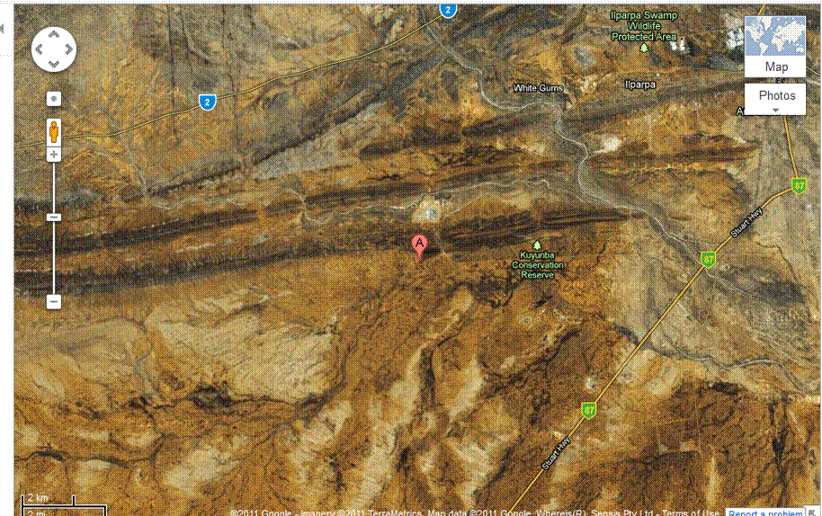
click zoom in once and you will see this:
weird right, heavy cloud cover might be hiding something..not to mention the discolouration in the ground and obvious cropping to the left.
it seems to the edited in image is from a perhaps older image..but either way its suspicious
there is a great deal of conspiracy history around this location..it is one of australias most secret military bases, convenintley located close to the middle of no where.
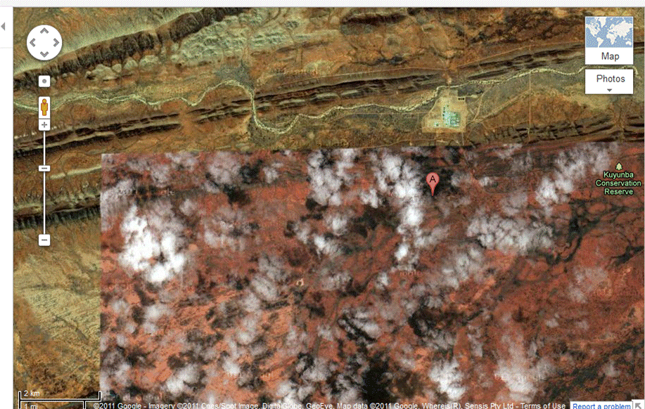
if you zoom up to the outline of the edited in square, you will see that close to the base it is edited together very well. but when you go further to the left (of the above picture) you can see that the edit is more obvious
just below the edited area on the highway you can see this:
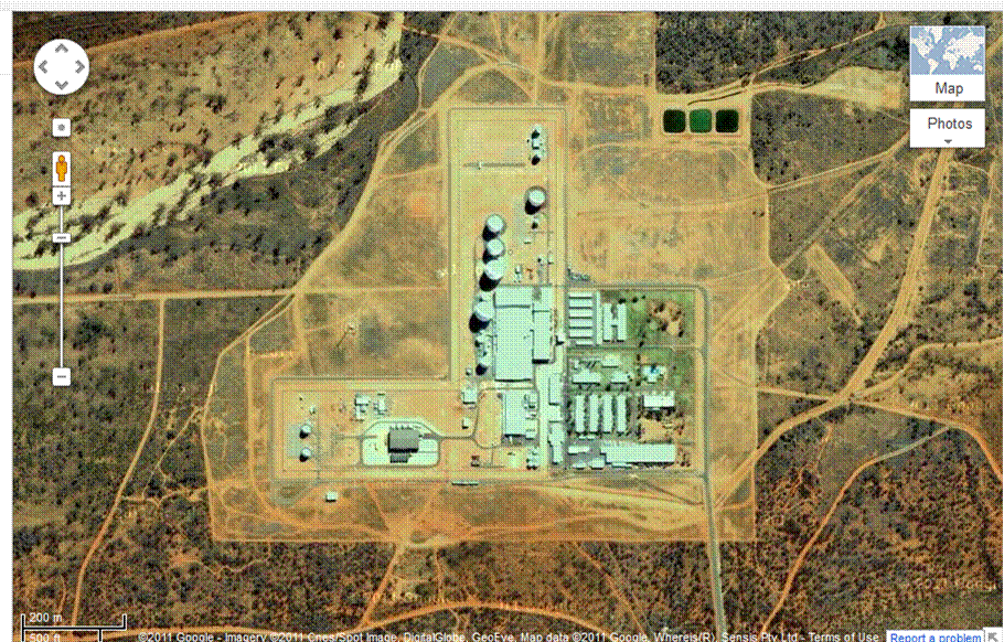
directly above the edited area you can see this facility. i think it is the military base.
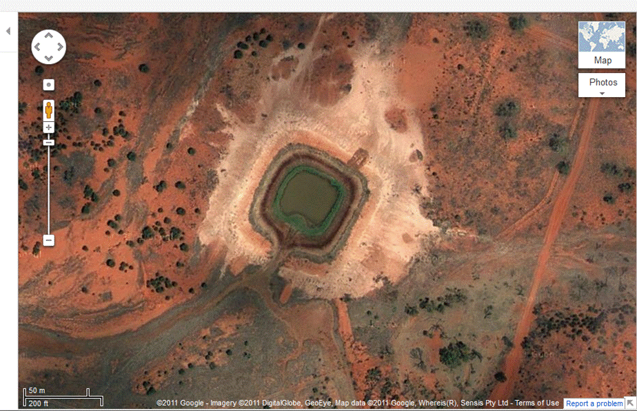
this thing that looks like a dam can be found in the edited area of the map, its not really suspicious just seems out of place to me
i dont really know what to make of it. i just think its highly suspicious to have happened in such a conspiracy hotspot..they have always been very quiet about this base..
Anyway search 'Pine Gap Hugh NT 0872' in google maps, you should see this:
click zoom in once and you will see this:
weird right, heavy cloud cover might be hiding something..not to mention the discolouration in the ground and obvious cropping to the left.
it seems to the edited in image is from a perhaps older image..but either way its suspicious
there is a great deal of conspiracy history around this location..it is one of australias most secret military bases, convenintley located close to the middle of no where.
if you zoom up to the outline of the edited in square, you will see that close to the base it is edited together very well. but when you go further to the left (of the above picture) you can see that the edit is more obvious
just below the edited area on the highway you can see this:
directly above the edited area you can see this facility. i think it is the military base.
this thing that looks like a dam can be found in the edited area of the map, its not really suspicious just seems out of place to me
i dont really know what to make of it. i just think its highly suspicious to have happened in such a conspiracy hotspot..they have always been very quiet about this base..
edit on 15-10-2011 by ShortMemory because: (no reason given)
Originally posted by ShortMemory
If your not aware there are a few conspiracies floating around about pine gap in australias Northern Terriotry. A quick ats search should show you a bit.
There could be a simpler explanation.
The higher resolution ground images are not taken from satellites, but are in fact taken from aircraft.
These aircraft ideally do multiple passes over any area, so as to get good shots with no cloud cover. Being better imnages, they are then worth more to the organisation they onsell the images to.
It could just be that they didnt get clearance to fly over pine gap, so couldnt get the great cloud-free images they want. I wouldnt expect an aerial photography organisation to be able to get clearance very easy for that kind of thing.
I'm not thinking its any Google conspiracy.
Originally posted by alfa1
Originally posted by ShortMemory
If your not aware there are a few conspiracies floating around about pine gap in australias Northern Terriotry. A quick ats search should show you a bit.
There could be a simpler explanation.
The higher resolution ground images are not taken from satellites, but are in fact taken from aircraft.
These aircraft ideally do multiple passes over any area, so as to get good shots with no cloud cover. Being better imnages, they are then worth more to the organisation they onsell the images to.
It could just be that they didnt get clearance to fly over pine gap, so couldnt get the great cloud-free images they want. I wouldnt expect an aerial photography organisation to be able to get clearance very easy for that kind of thing.
I'm not thinking its any Google conspiracy.
hmm i hear what your saying but what i think is the base has the good images, its underneath it that is edited in.
reply to post by ShortMemory
Nothing is being hidden, it's the way google maps/earth is put together.
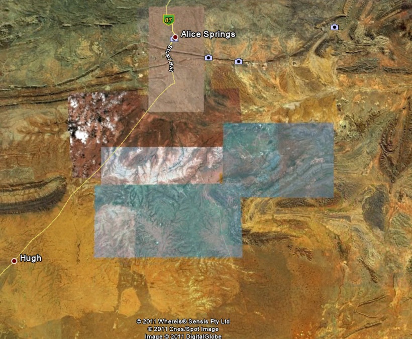
Here's the area zoomed out on google earth:
The images are stitched together and at times areas will be photographed at different times, it's more apparent in places like this due to the wet season and dry season.
Nothing is being hidden, it's the way google maps/earth is put together.
Here's the area zoomed out on google earth:
The images are stitched together and at times areas will be photographed at different times, it's more apparent in places like this due to the wet season and dry season.
reply to post by Chadwickus
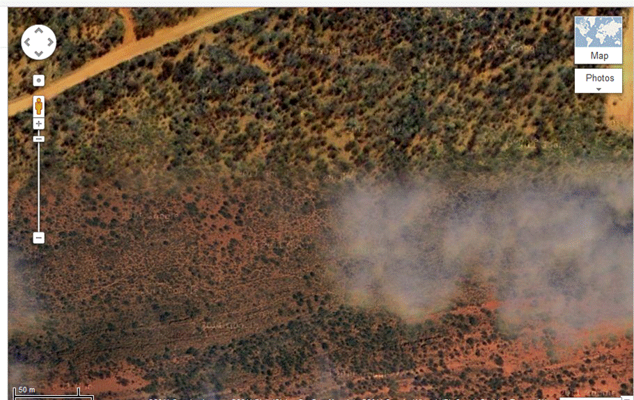
i just find it a bit weird there is heavy cloud cover right underneath the military base..
not to mention all areas around your image are not like this.
im not saying its a conspiracy, just placed in the a suspicious place
i just find it a bit weird there is heavy cloud cover right underneath the military base..
not to mention all areas around your image are not like this.
im not saying its a conspiracy, just placed in the a suspicious place
Bear with me, it might seem irrelevant or off-topic at first - but - it's not.
In 1991 I saw a PBS show on HAARP. Part was on the Alaskan field, and part of the show was on the Pine Gap facility in Australia. The PBS write-up on that original story on HAARP and that show was on the Internet in the mid to late 90's and later pulled, erased. It was later replaced with the current "what we WANT you to believe" Official Story on HAARP.
Anyway, I remember the Pine Gap facility and it had the huge ROUND golf ball (geodesic dome) building and a few large (humongous) satellite dishes. I 'think' I remember a couple small square concrete buildings ... overall, the complex did NOT have a large 'footprint'. It was mostly an Underground facility.
Anyway, my point is, the buildings (too many) and no geodesic dome shape building in the map above tells me that's NOT the area you might have been searching for.
That might be an additional group of building; but, if you were looking for the HAARP specific one - it's NOT pictured in the posts above.
reply to post by Trexter Ziam
fair enough thanks for posting that, ive never really looked into pine gap much before today and when i searched pine gap in google maps this is what i found.
just thought it was weird considering it looks like its near a military like area.
even if these pics are irrelivant, dodgy stuff does go on around there..
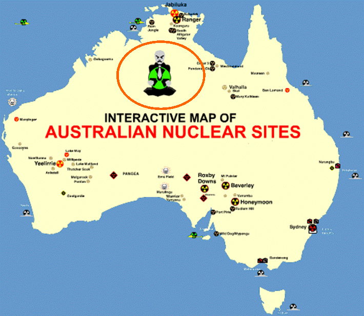
With a flag like this...
www.australianmap.net...
...included on the above map, you never know mate...
www.australianmap.net...
...included on the above map, you never know mate...
reply to post by ShortMemory
I agree. That would be part of the facility, a newer (since 1991) part. Alice Springs is the correct area for sure, I do remember that much.
It USED to be a joint US Navy and Australian (something or other) facility. I remember reading somewhere many years back that the US Navy is no longer affiliated. Whether that's true or not - or part of the cover-up, I don't know. A lease, expired lease or whatever may have been involved, I can't remember for sure now what the deal was.
Originally posted by AussieAmandaC
With a flag like this...
www.australianmap.net...
...included on the above map, you never know mate...
is this what your talking about?
your right you never know, i didnt post this because i thought it was a real conspiracy.. just i know that some stuff goes on around there and the more people know the better
thanks for your input
Originally posted by Trexter Ziam
reply to post by ShortMemory
I agree. That would be part of the facility, a newer (since 1991) part. Alice Springs is the correct area for sure, I do remember that much.
It USED to be a joint US Navy and Australian (something or other) facility. I remember reading somewhere many years back that the US Navy is no longer affiliated. Whether that's true or not - or part of the cover-up, I don't know. A lease, expired lease or whatever may have been involved, I can't remember for sure now what the deal was.
ok thats what i thought, and if theres one thing i know about military bases is they own a lot of land and put the bases near the middle..so the area directly below would most likely be owned by the military
hmm if it was a lease issue that seems strange to me, i dont think that leases would be important when it comes to the us army in australia.
id say they are still there..if they had a reason to build a base in the middle of no where id say they still have that reason..
apparently theres a lot of underground structures.. i try to take everything with a bit of salt but i know for sure something is dodgy around there..
Originally posted by alfa1
Originally posted by ShortMemory
If your not aware there are a few conspiracies floating around about pine gap in australias Northern Terriotry. A quick ats search should show you a bit.
There could be a simpler explanation.
The higher resolution ground images are not taken from satellites, but are in fact taken from aircraft.
These aircraft ideally do multiple passes over any area, so as to get good shots with no cloud cover. Being better imnages, they are then worth more to the organisation they onsell the images to.
It could just be that they didnt get clearance to fly over pine gap, so couldnt get the great cloud-free images they want. I wouldnt expect an aerial photography organisation to be able to get clearance very easy for that kind of thing.
I'm not thinking its any Google conspiracy.
Nice complete answer......posted 10 minutes after the question.
I know there are magnetic gravity anomalies here. They may be natural, or maybe it's something underground. Either way, I believe something weird
is definitely going on there, what ever it may be. For sure something John Q. Public is not supposed to know about. Here is an interesting link. At
the bottom of the page are the maps with the magnetic gravity anomalies on them. Cheers.....
www.thelivingmoon.com...
www.thelivingmoon.com...
edit on 15/10/11 by gunshooter because: (no reason given)
reply to post by ShortMemory
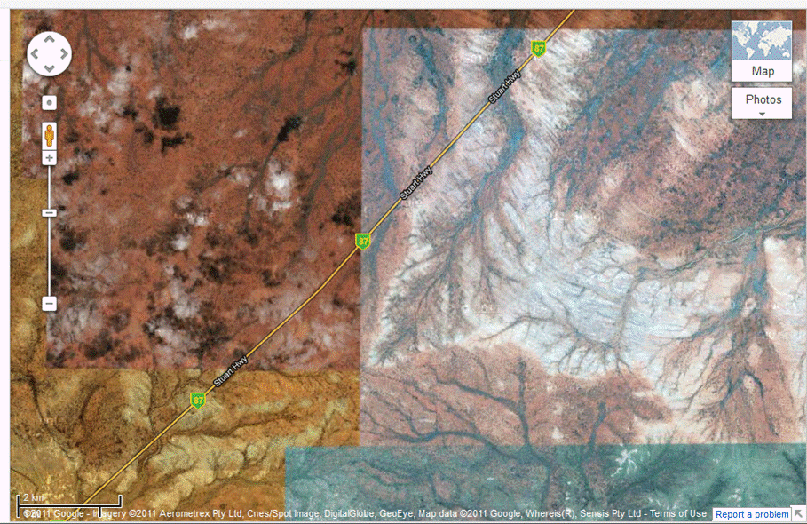
Using Google Earth historical imagery, you can see a better view, in the 2009 image.
It probably is some sort of security issue-- a prison is in there. But more than likely it is to dissuade access from the south to the Pine Gap installation.
I believe Google cooperates with governments on such things. Nations need to be allowed their secrets, and Nations can disallow Google, so it is a healthy and law-abiding compromise. To overfly a sensitive installation, requires permission, and sufficiently obscured images may be provided as a courtesy by the government.
In my many years using Google Earth (for historical work and just fun browsing) one would think every single US Air Force base has no planes! They are in hangers, or aloft, or moved from one side for a photographic pass and then moved to the other for the next overflight or more simply digitally removed. I used to see some sections of military installations simply whited-out. No doubt, this is to keep an enemy from having a precise count of US aircraft.
My guess concerning the reddish image south of Pine Gap is that since the 2009 image some security measures (like a fence) have been added.
reply to post by Chadwickus
it would still be owned by the military tho, they put their bases in the middle of the land they own..so considering the edited version is directly below the base id say they own it.
it would still be owned by the military tho, they put their bases in the middle of the land they own..so considering the edited version is directly below the base id say they own it.
Originally posted by gunshooter
I know there are magnetic gravity anomalies here. They may be natural, or maybe it's something underground. Either way, I believe something weird is definitely going on there, what ever it may be. For sure something John Q. Public is not supposed to know about. Here is an interesting link. At the bottom of the page are the maps with the magnetic gravity anomalies on them. Cheers.....
www.thelivingmoon.com...edit on 15/10/11 by gunshooter because: (no reason given)
thanks for that link, gives a great history..how about the bloke that was forced to give up 900 acres of land for $970..thats a great example of military power.
yeah when you start digging into the pine gap topic, something is not right..
how i wish there was transperancy.
apparently there are weather anomalies that spawn from this area and other places around the top end
edit on 15-10-2011 by ShortMemory because:
(no reason given)
reply to post by ShortMemory
Who's in charge of the darn smoke machine. Thanx 4 reminding me of an old favourite song of mine. But I'll try 2 help with ur post quick also. . .zoom in till u cant zoom no more, Charlie Brown should be there somewhere looking for his BLANKET. Just another glitch brought 2 u by Google Naps.
Who's in charge of the darn smoke machine. Thanx 4 reminding me of an old favourite song of mine. But I'll try 2 help with ur post quick also. . .zoom in till u cant zoom no more, Charlie Brown should be there somewhere looking for his BLANKET. Just another glitch brought 2 u by Google Naps.
reply to post by ShortMemory
No it was the one above it (on the same page of my link)
which shows greater detail.
Cheers
No it was the one above it (on the same page of my link)
which shows greater detail.
Cheers
new topics
-
Where should Trump hold his next rally
2024 Elections: 2 hours ago -
Shocking Number of Voters are Open to Committing Election Fraud
US Political Madness: 3 hours ago -
Gov Kristi Noem Shot and Killed "Less Than Worthless Dog" and a 'Smelly Goat
2024 Elections: 4 hours ago -
Falkville Robot-Man
Aliens and UFOs: 4 hours ago -
James O’Keefe: I have evidence that exposes the CIA, and it’s on camera.
Whistle Blowers and Leaked Documents: 4 hours ago -
Australian PM says the quiet part out loud - "free speech is a threat to democratic dicourse"...?!
New World Order: 5 hours ago -
Ireland VS Globalists
Social Issues and Civil Unrest: 6 hours ago -
Biden "Happy To Debate Trump"
2024 Elections: 6 hours ago -
RAAF airbase in Roswell, New Mexico is on fire
Aliens and UFOs: 6 hours ago -
What is the white pill?
Philosophy and Metaphysics: 8 hours ago
top topics
-
A Warning to America: 25 Ways the US is Being Destroyed
New World Order: 16 hours ago, 21 flags -
Blast from the past: ATS Review Podcast, 2006: With All Three Amigos
Member PODcasts: 9 hours ago, 13 flags -
James O’Keefe: I have evidence that exposes the CIA, and it’s on camera.
Whistle Blowers and Leaked Documents: 4 hours ago, 12 flags -
Australian PM says the quiet part out loud - "free speech is a threat to democratic dicourse"...?!
New World Order: 5 hours ago, 11 flags -
Biden "Happy To Debate Trump"
2024 Elections: 6 hours ago, 10 flags -
Mike Pinder The Moody Blues R.I.P.
Music: 9 hours ago, 8 flags -
Ireland VS Globalists
Social Issues and Civil Unrest: 6 hours ago, 5 flags -
RAAF airbase in Roswell, New Mexico is on fire
Aliens and UFOs: 6 hours ago, 5 flags -
What is the white pill?
Philosophy and Metaphysics: 8 hours ago, 5 flags -
Putin, Russia and the Great Architects of the Universe
ATS Skunk Works: 12 hours ago, 4 flags
active topics
-
Gov Kristi Noem Shot and Killed "Less Than Worthless Dog" and a 'Smelly Goat
2024 Elections • 29 • : lincolnriley -
Krystalnacht on today's most elite Universities?
Social Issues and Civil Unrest • 11 • : TheWoker -
Remember These Attacks When President Trump 2.0 Retribution-Justice Commences.
2024 Elections • 59 • : TzarChasm -
Salvador Dali's Moustaches
People • 29 • : GENERAL EYES -
Mood Music Part VI
Music • 3111 • : TheWoker -
Where should Trump hold his next rally
2024 Elections • 12 • : StudioNada -
University of Texas Instantly Shuts Down Anti Israel Protests
Education and Media • 310 • : SchrodingersRat -
Candidate TRUMP Now Has Crazy Judge JUAN MERCHAN After Him - The Stormy Daniels Hush-Money Case.
Political Conspiracies • 815 • : Annee -
President BIDEN's FBI Raided Donald Trump's Florida Home for OBAMA-NORTH KOREA Documents.
Political Conspiracies • 35 • : Threadbarer -
2024 Pigeon Forge Rod Run - On the Strip (Video made for you)
Automotive Discussion • 8 • : WhitewaterSquirrel
3