It looks like you're using an Ad Blocker.
Please white-list or disable AboveTopSecret.com in your ad-blocking tool.
Thank you.
Some features of ATS will be disabled while you continue to use an ad-blocker.

You know HAARP exists when you see........
page: 13
share:
Oh that is incredible. I am happy I was able to catch that in time to scrapbook it, and I tested it. The Interactive RSOE map DOES scrapbook with all
data and at zoom level for offline viewing. NICE! That shot will be a gem in my collection of screw ups that made it to a live page. It can't
possibly be a real track. That just can't happen. Can it????
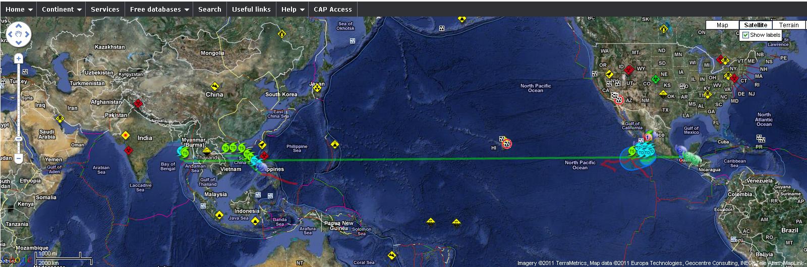
For anyone who comes upon this later after they correct it......they have to correct it right?? ..... The map RSOE is showing and ATS kinda cut off on the OP here shows the same Hurricane/Cyclone/Typhoon (I think it would technically change into all three) starting in the Gulf Of Mexico on Mexico's East Coast and crossing the entire Pacific ocean in a pefectly straight line to end where the OP map shows, in the Bay of Bengal off Thailand's West coast.
Okay... I have heard of long lived storms, but this little sucker transcends proper names. We can just call it 'The little storm that could'. LOL.... It's too funny. I mean... OP? This IS a glitch...right??
reply to post by Wrabbit2000
Just use the slide bar to scroll right on my pic.
It's a classic. I couldn't help but post it here.
Just use the slide bar to scroll right on my pic.
It's a classic. I couldn't help but post it here.
edit on 12-10-2011 by LightAssassin because: (no reason given)
reply to post by LightAssassin
Thanks! I'm having one of those nights... didn't even see the scroll bar.
Hey, just for laughs I went to check the National Hurricane Center where RSOE generates part of their map from....It doesn't show the track from hell crossing half the planet, but it DOES show that storm (TD Irwin) Approaching the Mexican coast and making a TIGHT and near perfect U-Turn just off the coast to head back...where that long track projects it heading for a vacation in Thailand on RSOE.
I've never seen a Tropical Depression make a perfect and tight U-Turn like that before ?? Much less...seen it predicted in advance? Okay...There must be a logical reason here.
reply to post by Wrabbit2000
Hahaha, grab a screeny of it and post it here.
Logic seems to have left this planet some time during Sept 2001.
Hahaha, grab a screeny of it and post it here.
Logic seems to have left this planet some time during Sept 2001.
edit on 12-10-2011 by LightAssassin because: (no reason given)
You know HAARP exists when you see clouds in the sky.
You know HAARP exists when you see the sky is blue.
You know HAARP exists when it rains.
You know HAARP exists when there is thunder.
You know HAARP exists when you see a star in the sky.
You know HAARP exists when you fart at night.
You know HAARP exists when your urine is clear.
You know HAARP exists when you get an erection.
edit on 12-10-2011 by Somehumanbeing because: (no reason given)
edit on
12-10-2011 by Somehumanbeing because: (no reason given)
reply to post by Somehumanbeing
"We have a patient escaped from Ward D, Psych Ward. I repeat, We have a patient escaped from Ward D"
"We have a patient escaped from Ward D, Psych Ward. I repeat, We have a patient escaped from Ward D"
I cannot get a screen shot of that map with all it's details as an image for the life of me. RSOE? Yes. National Hurricane Center? Nope. The image is
many overlaid, even when scrapbooked as an offline page. Oh well, here is the link that shows it directly for as long as it's up there like this.
Maybe others who watch these from areas that get hit (watch much closer than I) have seen this before....I just call it odd??
www.nhc.noaa.gov...
Quick FYI... I went into the raw data and downloaded every projected track they had onto Google Earth to see if this was ONE track that somehow slipped through.... It's not. It showed a number of tracks predicted with very slight variations to this same U-Turn track. Hmm...
edit on
12-10-2011 by Wrabbit2000 because: (no reason given)
new topics
-
A Warning to America: 25 Ways the US is Being Destroyed
New World Order: 3 hours ago -
President BIDEN's FBI Raided Donald Trump's Florida Home for OBAMA-NORTH KOREA Documents.
Political Conspiracies: 9 hours ago -
Maestro Benedetto
Literature: 10 hours ago -
Is AI Better Than the Hollywood Elite?
Movies: 10 hours ago
top topics
-
President BIDEN's FBI Raided Donald Trump's Florida Home for OBAMA-NORTH KOREA Documents.
Political Conspiracies: 9 hours ago, 28 flags -
Gaza Terrorists Attack US Humanitarian Pier During Construction
Middle East Issues: 15 hours ago, 8 flags -
Massachusetts Drag Queen Leads Young Kids in Free Palestine Chant
Social Issues and Civil Unrest: 17 hours ago, 7 flags -
Las Vegas UFO Spotting Teen Traumatized by Demon Creature in Backyard
Aliens and UFOs: 14 hours ago, 6 flags -
A Warning to America: 25 Ways the US is Being Destroyed
New World Order: 3 hours ago, 6 flags -
Meadows, Giuliani Among 11 Indicted in Arizona in Latest 2020 Election Subversion Case
Mainstream News: 17 hours ago, 5 flags -
2024 Pigeon Forge Rod Run - On the Strip (Video made for you)
Automotive Discussion: 15 hours ago, 4 flags -
Is AI Better Than the Hollywood Elite?
Movies: 10 hours ago, 3 flags -
The functionality of boldening and italics is clunky and no post char limit warning?
ATS Freshman's Forum: 16 hours ago, 1 flags -
Maestro Benedetto
Literature: 10 hours ago, 1 flags
active topics
-
Alternate Electors vs Fake Electors - What is the Difference.
2024 Elections • 116 • : Threadbarer -
Gaza Terrorists Attack US Humanitarian Pier During Construction
Middle East Issues • 34 • : AllisVibration -
Victoria government has cancelled the commmonwealth games, no money.
Regional Politics • 3 • : nazaretalazareta -
A Warning to America: 25 Ways the US is Being Destroyed
New World Order • 2 • : Disgusted123 -
President BIDEN's FBI Raided Donald Trump's Florida Home for OBAMA-NORTH KOREA Documents.
Political Conspiracies • 19 • : ADVISOR -
When an Angel gets his or her wings
Religion, Faith, And Theology • 22 • : AcrobaticDreams1 -
King Charles 111 Diagnosed with Cancer
Mainstream News • 321 • : FlyersFan -
Is there a hole at the North Pole?
ATS Skunk Works • 41 • : burritocat -
Massachusetts Drag Queen Leads Young Kids in Free Palestine Chant
Social Issues and Civil Unrest • 16 • : FlyersFan -
Weinstein's conviction overturned
Mainstream News • 24 • : burritocat
3