It looks like you're using an Ad Blocker.
Please white-list or disable AboveTopSecret.com in your ad-blocking tool.
Thank you.
Some features of ATS will be disabled while you continue to use an ad-blocker.

What might really be happening in Washington State?
page: 39share:
you ok my friend? did you feel it?
I happened to click on usgs at the right time, posted screen shot at quake watch
I happened to click on usgs at the right time, posted screen shot at quake watch
reply to post by berkeleygal
Nope! Not even a tiddely-bit.
I am going for a walk now. Absolutely gorgeous outside. I'll be sure to pay attention to any subtle rumblings.
I always get a bit more interested when I see action on both ends like this. It also makes me wonder if those two quakes near seattle the past day could be in relation to the transfer of energy. They are at the same depth!
Well....
This just half an hour ago:
And...
This afternoon:
Then ofcourse the one down in california yesterday:
What's it mean? Well, I sure as heck don't like it. I think there is more to come.
source
This just half an hour ago:
Magnitude 6.0
Date-Time Wednesday, February 15, 2012 at 03:31:20 UTC
Tuesday, February 14, 2012 at 07:31:20 PM at epicenter
Time of Earthquake in other Time Zones
Location 43.536°N, 127.381°W
Depth 10 km (6.2 miles)
Region OFF THE COAST OF OREGON
Distances 256 km (159 miles) W of Coos Bay, Oregon
293 km (182 miles) WSW of Newport, Oregon
302 km (187 miles) NW of Brookings, Oregon
380 km (236 miles) WSW of SALEM, Oregon
Location Uncertainty horizontal +/- 19.7 km (12.2 miles); depth +/- 6.2 km (3.9 miles)
Parameters NST=205, Nph=211, Dmin=282.8 km, Rmss=1.15 sec, Gp=180°,
M-type=regional moment magnitude (Mw), Version=6
Source Magnitude: USGS NEIC (WDCS-D)
Location: USGS NEIC (WDCS-D)
Event ID usb00080ib
And...
This afternoon:
Magnitude 4.2
Date-Time Tuesday, February 14, 2012 at 22:54:40 UTC
Tuesday, February 14, 2012 at 02:54:40 PM at epicenter
Time of Earthquake in other Time Zones
Location 49.214°N, 128.751°W
Depth 10 km (6.2 miles)
Region VANCOUVER ISLAND, CANADA REGION
Distances 191 km (118 miles) SSW of Port Hardy, British Columbia, Canada
235 km (146 miles) W of Ucluelet, British Columbia, Canada
268 km (166 miles) WSW of Campbell River, British Columbia, Canada
405 km (251 miles) WNW of VICTORIA, British Columbia, Canada
Location Uncertainty horizontal +/- 25 km (15.5 miles); depth +/- 2.7 km (1.7 miles)
Parameters NST= 33, Nph= 33, Dmin=268.3 km, Rmss=0.65 sec, Gp=212°,
M-type=body wave magnitude (Mb), Version=9
Source Magnitude: USGS NEIC (WDCS-D)
Location: USGS NEIC (WDCS-D)
Event ID usb00080ej
Then ofcourse the one down in california yesterday:
Magnitude 5.6
Date-Time Monday, February 13, 2012 at 21:07:02 UTC
Monday, February 13, 2012 at 01:07:02 PM at epicenter
Time of Earthquake in other Time Zones
Location 41.143°N, 123.790°W
Depth 28.2 km (17.5 miles)
Region NORTHERN CALIFORNIA
Distances 9 km (5 miles) SW (234°) from Weitchpec, CA
28 km (17 miles) NNW (343°) from Willow Creek, CA
29 km (18 miles) ENE (67°) from Westhaven-Moonstone, CA
50 km (31 miles) NE (38°) from Eureka, CA
349 km (217 miles) NW (326°) from Sacramento, CA
Location Uncertainty horizontal +/- 0.4 km (0.2 miles); depth +/- 1.2 km (0.7 miles)
Parameters Nph= 47, Dmin=20 km, Rmss=0.27 sec, Gp= 72°,
M-type=regional moment magnitude (Mw), Version=8
Source California Integrated Seismic Net:
USGS Caltech CGS UCB UCSD UNR
Event ID nc71734741
What's it mean? Well, I sure as heck don't like it. I think there is more to come.
source
So yah...I'm one of those smaller cities to the North of Seattle. Pretty much covered in red a couple minutes into this scenario. This is why I
watch this stuff so much. Here's to hoping all these quakes are not building up to something and things quiet back down.
This is a simulation of a 9.0 quake and rupture of the CSZ
This is a simulation of a 9.0 quake and rupture of the CSZ
Great video, wc...and completely scary! I'm going to try to grab a screen capture of the entire theorized rupture zone from the end of the video.
It will be nice to have to overlay current quake activity.
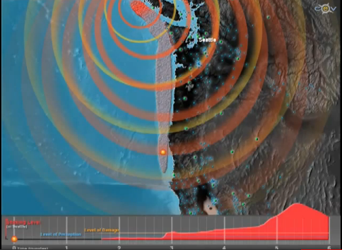
The scenario in the vid shows this entire raised, gray area offshore rupturing from south to north. The turn the quake takes up near the olymipic pennisula--and then continues north, is wild.
The scenario in the vid shows this entire raised, gray area offshore rupturing from south to north. The turn the quake takes up near the olymipic pennisula--and then continues north, is wild.
edit on 2/16/2012 by Olivine because: add screenshot
reply to post by Olivine
Yup...pretty crazy. This is why when I see deeper quakes near the shore I sit up a bit straighter.
They used to think it was further West out at sea, but changed their minds a few years back.
Yup...pretty crazy. This is why when I see deeper quakes near the shore I sit up a bit straighter.
They used to think it was further West out at sea, but changed their minds a few years back.
If you take a look at the USGS map for the Oregon coastal area it appears that they have moved the quakes????
So aftershocks then of the other quake? I am hoping that this leans toward the positive as far as the PNW is concerned?
So aftershocks then of the other quake? I am hoping that this leans toward the positive as far as the PNW is concerned?
edit on 16-2-2012 by nonnez because: Question added
reply to post by nonnez
Yeah, the Director for the PNSN was talking about the placement USGS gave them from the begining. I guess those off-shore quakes are difficult to place due to their location. He could 'see' right away though that they were further West than listed, so I expected to see those moved.
Personally, I think it is a good thing as far as the CSZ is concerned.
I will go out and say that I DO expect to see another 5+ quake near Vancouver soon (I feel it will be 6 or slightly larger, but I have no real reason for it. 6.4 stands out). Only deep tremors now for the past few days were today, clustered down south. Given the 5.9 off-shore Southern Oregon, the smaller 4-5 mag quakes near Vancouver recently and, well, gut instinct.
I'm feeling kinda dumb that I didn't make this connection sooner. Perhaps someone else did (probably) and I just didn't see it. BUT:
I started a thread a bit ago at utahRosebuds urging with info about a Magma Uplift in Oregon.
HERE is the article regarding what is happening. Essentially, there is magma intrusion and uplift to the West of the Three Sisters in Southern Oregon. They believe there may soon be the birth/eruption of a new volcano. Interesting stuff.
Here's the connection:
With the increased EQ activity along the coast recently, could there be a correlation? The leading theory is that the Cascade Volcanic Chain is fed by the subduction zone...that at the point of friction the rock becomes molten and has to find a way to the surface...hence a volcano. So would it be a stretch to consider this new volcano a possible sign of things moving or heating up down below in the subduction zone?
I mean, come on. When was the last time we saw a volcano created in the Pacific Northwest?
I'm guessing it was right around the time of one of the mega quakes? I dunno...but I am going to ask.
edit on 18-2-2012 by westcoast because:
(no reason given)
edit on 18-2-2012 by westcoast because: (no reason given)
edit on 18-2-2012 by westcoast because:
(no reason given)
Originally posted by westcoast
The leading theory is that the Cascade Volcanic Chain is fed by the subduction zone
Correct
...that at the point of friction the rock becomes molten and has to find a way to the surface...hence a volcano.
Not quite correct, at least as far as I understand subduction zones--and I could be completely wrong.
The magma under a volcano isn't formed because of friction. It is theorized that volatiles, such as water and carbon dioxide, contained in minerals in the subducting slab, begin to "bubble" out when the slab heats up as it sinks deeper into the surrounding hot asthenosphere. The addition of the volatiles lowers the melting temperature of the peridotite (ultramafic rock) of the asthenosphere--which produces a basaltic magma (high in iron and magnesium and low in silica).
This basalt either rises directly to the surface and erupts, or it can get trapped below, or in, the continental crust. When this happens, the heat from the basaltic magma can heat the surrounding crustal rock (which contains more silica), causing partial melting, which gives rise to more silicic lavas--like the andesites and rhyolites we see in the Cascades volcanoes.
I hope this makes sense. I wrote it off the top of my head...I'll be back with a linky. Subduction Zone Volcanoes
However, as to the recent earthquake activity and how it relates to the associated uplift at South Sister--no clue. I've not found a source that gives a clear timeline of cause and effect between subduction megaquakes and following eruptions.
My guess is that it could be on the order of tens to hundreds of years--and that every subduction zone/volcanic arc is different. Different subducting slab dip angles, different ages of subducting slabs (the older they are, the colder they are, and hence sink more easily.), different compositions of continental crust minerals, etc.
edit on 2/18/2012 by Olivine because: spelling
edit on 2/18/2012 by Olivine
because: add a link
edit on 2/18/2012 by Olivine because: spelling
Hi Westcoast, long time no participate.
Saw these today and I guess you've seen the first link, but I thought of you so thought I'd post the links anyway.
Seattle Times
Inside Rainier:
Saw these today and I guess you've seen the first link, but I thought of you so thought I'd post the links anyway.
Seattle Times
Inside Rainier:
reply to post by zenius
Ha! I came here to post a link to the same article.
I especially don't like this comment:
@olivine...thanks for the explanation, I believe you are correct!
Ha! I came here to post a link to the same article.
I especially don't like this comment:
There's no obvious "supercyle" of supergiant quakes, as Satake suggests, in Japan. But it is clear that quakes on Cascadia have varied in size, said USGS scientist Brian Atwater. Some geologists argue the magnitude-9 quake 300 years ago was simply average and that the Northwest has been slammed by quakes twice as big in the distant past.
@olivine...thanks for the explanation, I believe you are correct!
reply to post by berkeleygal
I don't know if that is showing the same page now that you were refrencing? Are you talking about the red blob? If so, looks like a re-calibration to me. However, there is still a whole lotta poppin going on up there (as you can see) and it was reported by PNSN that there was yet another 'slide' event yesterday. It has never quieted down since this last 'event' (ice?) started!
I don't know if that is showing the same page now that you were refrencing? Are you talking about the red blob? If so, looks like a re-calibration to me. However, there is still a whole lotta poppin going on up there (as you can see) and it was reported by PNSN that there was yet another 'slide' event yesterday. It has never quieted down since this last 'event' (ice?) started!
reply to post by westcoast
Yep, the big red blob.. OK recalibration sounds good to me. Hope all is well with ya'll up there :-)
Yep, the big red blob.. OK recalibration sounds good to me. Hope all is well with ya'll up there :-)
Yeah, the big red blob is just a calibration pulse. It's all those little blobs, which are also showing up at RCM, I see, that aren't looking much
like ice quakes anymore. That looks more like seismicity now... Hmm...Time to well, you know, put the spectrum to em and find out...
old.pnsn.org...
EDIT: Nope. After spectrum, 99% of those smaller bumps are either noise or more ice quakes, and a lot more noise than ice quakes. I see very little, if any, seismic activity in all of that at both RCS and RCM.
old.pnsn.org...
edit on Wed Feb 22nd 2012 by TrueAmerican because: (no reason
given)
EDIT: Nope. After spectrum, 99% of those smaller bumps are either noise or more ice quakes, and a lot more noise than ice quakes. I see very little, if any, seismic activity in all of that at both RCS and RCM.
edit on Wed Feb 22nd 2012 by TrueAmerican because: (no reason given)
reply to post by TrueAmerican
Thanks for the info! Those webis are such a mess anymore I gave up on trying to read them on a regular basis.
Thanks for the info! Those webis are such a mess anymore I gave up on trying to read them on a regular basis.
The news mentioned a swarm of micro-quakes at Mt. Hood, and they even showed a graphic.
KOIN 6 news - from this article
Link
KOIN 6 news - from this article
Link
“You have two hypotheses – movement along a fault on the mountain (and there are lots of faults up there) or movement of magma to the surface. Anytime they are small and a swarm, there is a strong possibility that it is magma moving.”
Kind of weird to think about hot magma moving underneath the cold, snowy mountain you’re skiing and snowboarding on, isn’t it?
All two dozen micro-quakes on Mt. Hood have been less than magnitude 2. Now let’s see how many of these earthquakes we have before the mountain goes silent again!
I thought this was an interesting article. Westcoast has got me addicted to the PNSN site. The Native Americans in this area were know to say that the
mountains throw rocks at each other, maybe the sister will start doing just that.
www.pnsn.org... ars-of-mostly-silent-magma-inflation-near-three-sisters-oregon
Several conclusions are apparent. First, Sisters is active and bears close monitoring. Second, were this injection to lead to an eruption, it might form a new vent, however it is important to remember that much more magma is injected into the crust than erupted on the surface. Third, the volume injected is modest, so that it would take many such injections to provide the magma for a significant eruption. Fourth, we cannot count on seismicity to provide clear signals of injection - study of deformation is a critical complement to seismic monitoring.
www.pnsn.org... ars-of-mostly-silent-magma-inflation-near-three-sisters-oregon
reply to post by AuntB
I have read the story about the mountains throwing rocks, and that must have been something to see.
Enjoyed reading about the three sisters, and about the uplift. I could not get your link to work, but I found the story at:
PNSN link
I have read the story about the mountains throwing rocks, and that must have been something to see.
Enjoyed reading about the three sisters, and about the uplift. I could not get your link to work, but I found the story at:
PNSN link
new topics
-
StormyD Accused of Falsification of Business Records to Hide Money From Trump
US Political Madness: 9 hours ago -
Judge Postpones Trump Classified Docs Trial INDEFINITELY
US Political Madness: 11 hours ago
top topics
-
Judge Postpones Trump Classified Docs Trial INDEFINITELY
US Political Madness: 11 hours ago, 31 flags -
Don’t Obstruct the Leftist Implosion
US Political Madness: 16 hours ago, 27 flags -
StormyD Accused of Falsification of Business Records to Hide Money From Trump
US Political Madness: 9 hours ago, 17 flags -
To all ATS members of Faith - Prayer request
Religion, Faith, And Theology: 15 hours ago, 13 flags -
NASA Black Hole Visualization - Go Beyond the Brink
Space Exploration: 16 hours ago, 4 flags
active topics
-
Don’t Obstruct the Leftist Implosion
US Political Madness • 26 • : KrustyKrab -
Medvedev: “No one can hide, a global catastrophe is coming”
World War Three • 267 • : andy06shake -
Russia police launch major manhunt after troops massacred by comrade in occupied Ukraine
Other Current Events • 15 • : Maybenexttime -
Russians And Americans At Same Airbase In Niger But Not Sharing Restrooms
World War Three • 7 • : Beesnestbomber -
Tornado Obliterates Nebraska Building with Furious Anger
Fragile Earth • 11 • : Freeborn -
Sweet Home Alabama (metal cover by Leo Moracchioli)
Music • 5 • : Beesnestbomber -
They say justice is blind.
Religion, Faith, And Theology • 5 • : Beesnestbomber -
I have FINALLY solved the issue on how to stay alive during a police encounter!
Rant • 185 • : Beesnestbomber -
This is what it is all about
US Political Madness • 9 • : Beesnestbomber -
We are screwed
Global Meltdown • 23 • : Beesnestbomber