It looks like you're using an Ad Blocker.
Please white-list or disable AboveTopSecret.com in your ad-blocking tool.
Thank you.
Some features of ATS will be disabled while you continue to use an ad-blocker.

What might really be happening in Washington State?
page: 40share:
reply to post by PacificBlue
I've always given a great deal of merit to the Indian 'stories'....perhaps the most acurate form of historical data for this area dating that far back.
On that note, Puterman just sent me a link to a recent article found by another ATS member (probably posted here on ATS somewhere already, I am sure) that is quite interesting.
Monster Earthquake Looms....
So to go totally off-topic, I am wondering if any of my friends here are affilliated with or have personal knowledge of endocrinology? I need some help in this area, so if you think you could give some advice, please U2U me.
reply to post by westcoast
Thanks, that article is interesting, and it is also interesting that the First Nation Village is moving to higher ground. I agree that the Indian stories are the most accurate history of this area that we have. Some of the stories of tsunamis and floods that the Indian legends talk about, make it sound like entire areas were underwater for a while, so I hope that it is not time yet.
Also, the simulation video was scary, as I am currently residing under one of the big red circles. But I guess it is good to know what may happen, so one can kind of be prepared. I picture the Portland metro area looking a lot like Christchurch if we ever got a really big quake in the right spot, or maybe even worse.
So not a whole lot to talk about on this thread for awhile.....until today.
Just had a 3.6 shallow quake about ten miles from my house! (about an hour ago) I was outside when it happend, hiking around in the wilds behind my house. I heard what sounded like an explosion from a distance, with some resonation in the ground. I thought it a bit odd.....like an explosion, but with a different quality. If it was a quake did cross my mind, but more so that it might be Baker or Glacier peak (that are both about an hour from me) because of the boom quality. I made a mental note to check the seismos when I came inside, but my quake alert on my phone got me about a half hour later first.
HERE
Is a nearby webi....
SOURCE
I have asked PNSN Director John Vidale on the PNSN facebook site about it. If there was any different quality to the signal. Perhaps it is just because I was so close that it didn't seem like a typical quake.
Just had a 3.6 shallow quake about ten miles from my house! (about an hour ago) I was outside when it happend, hiking around in the wilds behind my house. I heard what sounded like an explosion from a distance, with some resonation in the ground. I thought it a bit odd.....like an explosion, but with a different quality. If it was a quake did cross my mind, but more so that it might be Baker or Glacier peak (that are both about an hour from me) because of the boom quality. I made a mental note to check the seismos when I came inside, but my quake alert on my phone got me about a half hour later first.
HERE
Is a nearby webi....
Magnitude 3.6
Date-Time Saturday, March 24, 2012 at 21:16:18 UTC
Saturday, March 24, 2012 at 02:16:18 PM at epicenter
Time of Earthquake in other Time Zones
Location 48.338°N, 122.272°W
Depth 8.5 km (5.3 miles)
Region WASHINGTON
Distances 4 km (2 miles) NW (311°) from Lake McMurray, WA
5 km (3 miles) E (93°) from Conway, WA
7 km (4 miles) SSW (203°) from Big Lake, WA
79 km (49 miles) N (3°) from Seattle, WA
Location Uncertainty horizontal +/- 0.3 km (0.2 miles); depth +/- 0.7 km (0.4 miles)
Parameters Nph= 39, Dmin=13 km, Rmss=0.26 sec, Gp= 47°,
M-type=local magnitude (ML), Version=2
Source Pacific Northwest Seismic Network
Event ID uw60404846
SOURCE
I have asked PNSN Director John Vidale on the PNSN facebook site about it. If there was any different quality to the signal. Perhaps it is just because I was so close that it didn't seem like a typical quake.
reply to post by westcoast
Any local ATS residents have an opinion or want to take a look at it? To my untrained eye it seems a little odd...but nothing obvious.
Any local ATS residents have an opinion or want to take a look at it? To my untrained eye it seems a little odd...but nothing obvious.
Hmmmm...no responses?
Oh well.....guess it was nothing too unusuall. Most likely just due to my location (being so close)
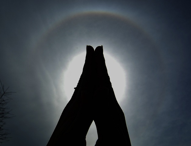
On another note, there was a nice sun halo yesterday. Perhaps all these halos mean Spring is finally here? I'm always trying to come up with new ways to photograph them.
Oh well.....guess it was nothing too unusuall. Most likely just due to my location (being so close)
On another note, there was a nice sun halo yesterday. Perhaps all these halos mean Spring is finally here? I'm always trying to come up with new ways to photograph them.
reply to post by westcoast
Now that's a cool picture!
Here's a suggestion, do you have a pair of HD sunglasses? Try taking a picture thru the lens of the glasses. I had on a pair not too long ago and looked at the sun, there was a halo that I could not see with the naked eye. Worth a try.
Now that's a cool picture!
Here's a suggestion, do you have a pair of HD sunglasses? Try taking a picture thru the lens of the glasses. I had on a pair not too long ago and looked at the sun, there was a halo that I could not see with the naked eye. Worth a try.
reply to post by westcoast
Unfortunately I can't read graphs or anything like that. But I had a 3.6 very near me last year in MD. boom, crackkkkkkkkkk....thud thud thud deep booming with shaking. If it hadn't been for the incredible shaking that followed, I would have thought one huge lightning bolt had struck one imaginary huge tree right down the street. The boom was loud and that crackkkkkkkkkk noise was like the ground ripping apart. But when I went out the next morning all was fine, there was no huge fissure one might expect to see after hearing the ground crack like that. Does any of this sound familiar? What exactly struck you odd?
Unfortunately I can't read graphs or anything like that. But I had a 3.6 very near me last year in MD. boom, crackkkkkkkkkk....thud thud thud deep booming with shaking. If it hadn't been for the incredible shaking that followed, I would have thought one huge lightning bolt had struck one imaginary huge tree right down the street. The boom was loud and that crackkkkkkkkkk noise was like the ground ripping apart. But when I went out the next morning all was fine, there was no huge fissure one might expect to see after hearing the ground crack like that. Does any of this sound familiar? What exactly struck you odd?
Okay, so I haven't posted on here in quite some time, but I think I need to update.
There has been discussion on other various threads regarding the recent moderate-sized quakes occuring off-shore Vancouver: (the most recent about an hour ago)
source
SO.....the problem with this, is it seems that USGS is only reporting quakes that are above a certain magnitude. Now this has come up before. I don't recall all the details, but I know I have discussed it in the past. Typically, USGS is triggered at 4.5 and above, but sometimes they'll be watching and listing some smaller ones (over 3.5) for the region because, well....perhaps because it is the Northern edge of the Cascadian subduction zone and may be the only warning we get for the next mega quake???!!!!!
*sigh*....I don't get it. Is it a border thing? Is it an issue with the two countries working together? Or is there really no issue other than that we, the public don't see the monitoring or communication going on between the different organizations? Because it really bothers me that USGS/PNSN do NOT list these quakes. I know they are watching. John Vidale (director for PNSN) has been talking about them on the PNSN facebook site and even provided a link to where we can see the REAL action going on there...it's kinda scary:
Canadian site for quakes near vancouver
There has been a MASSIVE amount this past week. I haven't counted them yet...but I will. I'll guess it's around three dozen or so.
If we were to move this swarm (yes, it is most definately a SWARM) to the region that we often see some 4-5 mag quakes off-shore Oregon, people would be literally throwing the red flags and running around. But because it is nestled up at the northern edge in Canadian waters.....we hear literally NOTHING about it. It makes NO sense! Now..it is quite important as to whether these are originating from the subducting plates, or another well-known fault in the area that is a strike-slip. Problem is...the USGS and the Canadian site don't even have the quakes in the same place. They are spread around a bit and have different depths. So...what then? Are they coming from both? I dunno, but it would be nice to have some more discussion on this!
What say you??
There has been discussion on other various threads regarding the recent moderate-sized quakes occuring off-shore Vancouver: (the most recent about an hour ago)
MAP 4.5 2012/05/01 22:53:50 50.683 -129.454 16.0 VANCOUVER ISLAND, CANADA REGION
MAP 3.8 2012/04/29 05:12:21 50.746 -129.741 10.0 VANCOUVER ISLAND, CANADA REGION
MAP 4.5 2012/04/28 03:42:24 50.594 -129.774 15.5 VANCOUVER ISLAND, CANADA REGION
MAP 4.0 2012/04/27 16:22:34 50.707 -129.607 5.0 VANCOUVER ISLAND, CANADA REGION
MAP 4.4 2012/04/27 12:52:47 50.630 -129.696 10.0 VANCOUVER ISLAND, CANADA REGION
MAP 3.9 2012/04/25 06:24:02 50.732 -129.995 27.8 VANCOUVER ISLAND, CANADA REGION
source
SO.....the problem with this, is it seems that USGS is only reporting quakes that are above a certain magnitude. Now this has come up before. I don't recall all the details, but I know I have discussed it in the past. Typically, USGS is triggered at 4.5 and above, but sometimes they'll be watching and listing some smaller ones (over 3.5) for the region because, well....perhaps because it is the Northern edge of the Cascadian subduction zone and may be the only warning we get for the next mega quake???!!!!!
*sigh*....I don't get it. Is it a border thing? Is it an issue with the two countries working together? Or is there really no issue other than that we, the public don't see the monitoring or communication going on between the different organizations? Because it really bothers me that USGS/PNSN do NOT list these quakes. I know they are watching. John Vidale (director for PNSN) has been talking about them on the PNSN facebook site and even provided a link to where we can see the REAL action going on there...it's kinda scary:
Canadian site for quakes near vancouver
There has been a MASSIVE amount this past week. I haven't counted them yet...but I will. I'll guess it's around three dozen or so.
If we were to move this swarm (yes, it is most definately a SWARM) to the region that we often see some 4-5 mag quakes off-shore Oregon, people would be literally throwing the red flags and running around. But because it is nestled up at the northern edge in Canadian waters.....we hear literally NOTHING about it. It makes NO sense! Now..it is quite important as to whether these are originating from the subducting plates, or another well-known fault in the area that is a strike-slip. Problem is...the USGS and the Canadian site don't even have the quakes in the same place. They are spread around a bit and have different depths. So...what then? Are they coming from both? I dunno, but it would be nice to have some more discussion on this!
What say you??
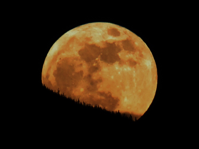
Thought I'd share my view of the super moon tonight with you all. It was a good one!!
reply to post by westcoast
Great picture, I really like how you can see the tops of the trees, that is neat. I was glad that it was not too cloudy last night to see the moon. And today is sunny and warm, finally, hope it is nice up where you are too!
Great picture, I really like how you can see the tops of the trees, that is neat. I was glad that it was not too cloudy last night to see the moon. And today is sunny and warm, finally, hope it is nice up where you are too!
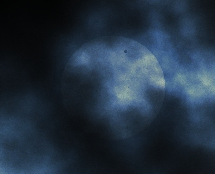
Well I managed to get a semi-decent picture of the venus transit! I got this from my back yard through a thin layer of clouds...
(You can see some sun spots too!! )
(You can see some sun spots too!! )
edit on 7-6-2012 by westcoast because: (no reason given)
reply to post by westcoast
I have NOT been on in so long that it took over 1/2 hour to find my password. I just wanted to say thank You for the beautiful photos, they are wonderful...
Heidi
I have NOT been on in so long that it took over 1/2 hour to find my password. I just wanted to say thank You for the beautiful photos, they are wonderful...
Heidi
reply to post by piercebitchone
Thank you! I am really glad you enjoy them!! I just think it's fun to share how things look from this part of the world...it's a beautiful place we live in.
Thank you! I am really glad you enjoy them!! I just think it's fun to share how things look from this part of the world...it's a beautiful place we live in.
reply to post by westcoast
What do ya make of were this one is located?
Earthquake Details
This event has been reviewed by a seismologist.
Magnitude
4.1
Date-Time
Thursday, June 07, 2012 at 23:19:26 UTC
Thursday, June 07, 2012 at 04:19:26 PM at epicenter
Location
58.104°N, 124.664°W
Depth
14.5 km (9.0 miles)
Region
BRITISH COLUMBIA, CANADA
Distances
137 km (85 miles) SW of Fort Nelson, British Columbia, Canada
247 km (153 miles) SSW of Fort Liard, NW Territories, Canada
990 km (615 miles) N of Vancouver, British Columbia, Canada
3566 km (2215 miles) NW of OTTAWA, Ontario, Canada
Location Uncertainty
horizontal +/- 17.3 km (10.7 miles); depth +/- 8.2 km (5.1 miles)
Parameters
NST= 81, Nph= 82, Dmin=500.9 km, Rmss=1.15 sec, Gp= 58°,
M-type=body wave magnitude (Mb), Version=6
Source
Magnitude: USGS NEIC (WDCS-D)
Location: USGS NEIC (WDCS-D)
Event ID
usb000aa4c
INFO
Wow. Has it really been FOUR months since I last posted???!!! Sorry that I didn't answer those last couple of questions...I just now saw
them.
I have obviously been busy and not around *here* much. Also...not a whole lot of activity to discuss recently (which is good).
I felt a need though to address the 7.7 quake that occured North of us up in Canada. I feel there may be some significance for us here in the Pacific NW. I also just wanted to check in my friends and see what you think.
I want to direct your attention to a report made by PNSN Director John Vidale HERE
Most pertinent to us:
There was at least one after-shock that drifted down South near Vancouver Island and possible into the subduction zone. This is what we need to be on the lookout for.
Be safe.
ETA: I also want to just mention that my *big* quake dog is extremely snuggly today. He is normally affectionate....but tonight he just keeps staring at me and seeking closeness. A bit odd. He hasn't done that in the past for quakes, but that it worth sharing.
I have obviously been busy and not around *here* much. Also...not a whole lot of activity to discuss recently (which is good).
I felt a need though to address the 7.7 quake that occured North of us up in Canada. I feel there may be some significance for us here in the Pacific NW. I also just wanted to check in my friends and see what you think.
I want to direct your attention to a report made by PNSN Director John Vidale HERE
Most pertinent to us:
This earthquake likely applied some additional stress to the faults we are concerned with in the Puget Sound and will have local aftershocks that are prominent for weeks. As usual, the chance of further seismic activity in the immediate vicinity of this earthquake will be higher than normal for a while, but does not rise to the level at which any actions are warranted.
There was at least one after-shock that drifted down South near Vancouver Island and possible into the subduction zone. This is what we need to be on the lookout for.
Be safe.
ETA: I also want to just mention that my *big* quake dog is extremely snuggly today. He is normally affectionate....but tonight he just keeps staring at me and seeking closeness. A bit odd. He hasn't done that in the past for quakes, but that it worth sharing.
edit on 28-10-2012 by
westcoast because: (no reason given)
I've been waiting to see if this thread popped up soon! I feel like this quake has a whole lot to do with down your way WC. I have no idea why I feel
that way, but I've never really felt like when pm reckoned it'd be another 55ish years until we see another 9+ that I agreed, when it came to the
PNW at least. I've said so many times on here how I'd love to visit that neck of the woods but something is stopping me from visiting. I keep
telling the Mr. "after the quake we'll go". Just a feeling!
Side note, where has TA been lately? I don't know, I just feel this needs more watching for some reason.
Side note, where has TA been lately? I don't know, I just feel this needs more watching for some reason.
Originally posted by westcoast
I felt a need though to address the 7.7 quake that occured North of us up in Canada. I feel there may be some significance for us here in the Pacific NW. I also just wanted to check in my friends and see what you think.
I missed this post Westcoast, but I definitely agree that it has significance to the PNW area.
The tremor restarted in your neck of the CSZ right around the time of the m7.7, and is continuing, although not as strongly, today. And the tremor at the southern end of Cascadia has been ongoing for 10 days now.
I've been looking at the GPS data and the plate boundary strainmeters. I'm trying to self-educate myself (which is a very slow tedious process--I am so very thick-headed at times ), but I feel like something is going on in the southern Olympics/northern Oregon coast area. I'd love to hear what the pros are seeing.
I'm watching this beast, too. Stay safe.
reply to post by Olivine
I agree...energy has shifted. It has to go somewhere.
The longer the area goes without another moderate sized after-shock, the more unselttling it becomes. I realize that not all large quakes have after-shocks, but this one obviously had a huge swarm right after. It abruptly dropped off after the 4.0 yesterday that was very shallow (1.1km) and now nothing over 4.0 to be registered by USGS.
reply to post by westcoast
Here we go! Bam, bam!
The start of something?
Here we go! Bam, bam!
MAP 3.0 2012/11/01 03:24:20 39.250 -122.719 7.2 NORTHERN CALIFORNIA
MAP 2.9 2012/11/01 03:20:03 39.248 -122.722 8.1 NORTHERN CALIFORNIA
MAP 4.9 2012/11/01 03:16:01 52.564 -131.943 10.3 QUEEN CHARLOTTE ISLANDS REGION
MAP 5.1 2012/11/01 03:15:23 52.500 -131.100 1.0 QUEEN CHARLOTTE ISLANDS REGION
The start of something?
new topics
-
VP's Secret Service agent brawls with other agents at Andrews
Mainstream News: 15 minutes ago -
Sunak spinning the sickness figures
Other Current Events: 56 minutes ago -
Nearly 70% Of Americans Want Talks To End War In Ukraine
Political Issues: 1 hours ago -
Late Night with the Devil - a really good unusual modern horror film.
Movies: 2 hours ago -
Cats Used as Live Bait to Train Ferocious Pitbulls in Illegal NYC Dogfighting
Social Issues and Civil Unrest: 4 hours ago -
The Good News According to Jesus - Episode 1
Religion, Faith, And Theology: 6 hours ago -
HORRIBLE !! Russian Soldier Drinking Own Urine To Survive In Battle
World War Three: 8 hours ago -
Bobiverse
Fantasy & Science Fiction: 11 hours ago -
Florida man's trip overseas ends in shock over $143,000 T-Mobile phone bill
Social Issues and Civil Unrest: 11 hours ago
top topics
-
Florida man's trip overseas ends in shock over $143,000 T-Mobile phone bill
Social Issues and Civil Unrest: 11 hours ago, 8 flags -
SETI chief says US has no evidence for alien technology. 'And we never have'
Aliens and UFOs: 15 hours ago, 7 flags -
Cats Used as Live Bait to Train Ferocious Pitbulls in Illegal NYC Dogfighting
Social Issues and Civil Unrest: 4 hours ago, 7 flags -
This is our Story
General Entertainment: 17 hours ago, 4 flags -
Former Labour minister Frank Field dies aged 81
People: 13 hours ago, 4 flags -
Bobiverse
Fantasy & Science Fiction: 11 hours ago, 3 flags -
HORRIBLE !! Russian Soldier Drinking Own Urine To Survive In Battle
World War Three: 8 hours ago, 2 flags -
Nearly 70% Of Americans Want Talks To End War In Ukraine
Political Issues: 1 hours ago, 2 flags -
Late Night with the Devil - a really good unusual modern horror film.
Movies: 2 hours ago, 2 flags -
VP's Secret Service agent brawls with other agents at Andrews
Mainstream News: 15 minutes ago, 1 flags
active topics
-
VP's Secret Service agent brawls with other agents at Andrews
Mainstream News • 4 • : SchrodingersRat -
President BIDEN Vows to Make Americans Pay More Federal Taxes in 2025 - Political Suicide.
2024 Elections • 120 • : ImagoDei -
Truth Social goes public, be careful not to lose your money
Mainstream News • 126 • : Zanti Misfit -
Nearly 70% Of Americans Want Talks To End War In Ukraine
Political Issues • 6 • : budzprime69 -
HORRIBLE !! Russian Soldier Drinking Own Urine To Survive In Battle
World War Three • 25 • : Freeborn -
Definitive 9.11 Pentagon EVIDENCE.
9/11 Conspiracies • 422 • : Zanti Misfit -
Breaking Baltimore, ship brings down bridge, mass casualties
Other Current Events • 482 • : IndieA -
How ageing is" immune deficiency"
Medical Issues & Conspiracies • 30 • : annonentity -
Remember These Attacks When President Trump 2.0 Retribution-Justice Commences.
2024 Elections • 55 • : Zanti Misfit -
SETI chief says US has no evidence for alien technology. 'And we never have'
Aliens and UFOs • 36 • : anthelion