It looks like you're using an Ad Blocker.
Please white-list or disable AboveTopSecret.com in your ad-blocking tool.
Thank you.
Some features of ATS will be disabled while you continue to use an ad-blocker.

On the Origins of Unexplained Maps
page: 1share:
On the Origins of Unexplained Maps
The following is an investigation into a series of cartographers (map-makers) who have themselves (whether partially or wholly) developed some maps which to this day do not comply with conventional history and the progression of science and man’s exploration of our world. When one examines the following with an open mind, one should not leave this thread without some sense of unease in regards to our accepted history. The content below was inspired by some of my favorite authors such as J.N. Wilford and G. Hancock.
“A good map is both a useful tool and a magic carpet to far away places.”
-Anon
Piri Reis was an Ottoman-Turk explorer, admiral and cartographer. He compiled his infamous map in 1513 at Constantinople. The map shows the western coasts of North Africa, the coast of Brazil and an ice-free Antarctica. This last fact is heavily disputed, but we would not be here if this were not the case. Considering the fact that Antarctica was ‘officially’ discovered in 1818, we are left with a perplexing conundrum. The depiction of the sub-glacial topography could not have been technologically possible in Piri Reis’ time or in a time prior to his, yet he had information depicting just this and conveyed it in his own way. Sub-glacial topography of the region was not officially mapped in modern history until as recently as 1949. To further enforce the oddity of this enigma, the last time that Queen Maud Land (the part of Antarctica depicted on the map) was in ice-free condition was no later than 4200B.C.E. It is not plausible therefore, for Piri Reis to have been the original cartographer of this area since it was still covered in ice during his time. So who was?
[atsimg]http://files.abovetopsecret.com/images/member/67b98905adf5.png[/atsimg]
PIRI REIS MAP [high resolution view]
Piri Reis wrote some notes on his map which detailed his sources. He admits that he was not the original cartographer of the works depicted in his map; he states that he merely compiled a number of source maps into one piece. He claimed to have used the source maps of Columbus among other earlier explorers, but some sources he claimed, went back to 400B.C.E. and even earlier. These source maps were most likely derived from the Imperial Library in Constantinople since this was Reis’ main source of information and where his map was originally discovered. Where did these source maps come from? Who could have mapped the topography of Antarctica prior to the glaciation before our modern era?
Oronteus Finaeus’ world map dates back to 1531. The map appears to depict the world (on the left) and the Antarctic continent (on the right). What may be even more startling than the Piri Reis map is that the Finaeus map depicts mountain ranges which match closely modern day sub-glacial analysis of the topography. Does this mean that not only were the Antarctic coasts explored but the mainland itself? Maybe, but inserting a plausible date for this would raise more eyebrows than the Piri Reis speculation, as it would mean that there were cartographers on the map no later than the end of the last Ice Age; the end of the last Ice Age glacial period was 12500 years ago!
[atsimg]http://files.abovetopsecret.com/images/member/4289f27a786a.png[/atsimg]
FINAEUS MAP [high resolution view]
Closer inspection of the map reveals not only mountain ranges, but rivers aswell. The depiction of the Ross Sea Ice Shelf shows indications of rivers where today there are glaciers such as the Beardmore which spill into the sea. What this means is that there was no ice in these areas when the source maps that Finaeus used were made. If these rivers did indeed exist then there would have had to have been woodlands in the area in order to feed the rivers. When testing was done in 1949 using core tubes to check the sediment layers at the bottom of the Ross Sea some interesting finds were made. They revealed that many layers were composed of fine grained sediments which could only have been brought down to the sea by flowing rivers. So was the Oronteus Finaeus map created from the same sources as the ones used by Piri Reis? Who could have charted these areas when they were inaccessible for the last 6000 years?
Gerard Kremer, also known as Mercator was a sixteenth century cartographer. He was widely known for his enigmatic behavior and was well recognized as a collector of antique maps. In his Atlas of 1569, Mercator depicts the Finaeus map, including Antarctica. Many areas which were then discovered are depicted on his map including Marie Byrd Land, Alexander I Island, the Weddell Sea and even the Regula Range in Queen Maud Land. In some cases the features are more visible and clearer than on the Finaeus map, perhaps suggesting that they had varying source maps?
[atsimg]http://files.abovetopsecret.com/images/member/bde653877cbb.png[/atsimg]
MERCATOR MAP [high resolution view]
The question still remains, how is it possible that these cartographers had such precise knowledge in a time when such advances were not supposed to have been made?
Perhaps we have saved the best for last (taking no credit from Mercator, perhaps the greatest map-maker). Philippe Buache was an 18th century French cartographer and geographer. What sets Buache aside from the likes of Reis, Finaeus and even Mercator, is that his depiction of Antarctica is one that is perhaps thousands of years older than any of the above. What Buache’s map shows is an Antarctica as it would have looked like completely ice-free! It is a complete sub-glacial topography of the entire continent!
[atsimg]http://files.abovetopsecret.com/images/member/a90c67081618.png[/atsimg]
BUACHE MAP [high resolution view]
The sources he used are now lost, but his map depicts Antarctica as two separate land masses, where as now there lie the Trans-Antarctic Mountains. The 1958 IGY survey shows that Antarctica is indeed an archipelago (a group of islands) connected by many mile-thick ice packed between them, sitting above the sea level. Therefore an ice-free Antarctica would mean that the waterway depicted in Buache’s map would have connected the Bellinghausen, Ross and Weddell seas. Therefore rendering Buache’s depiction strangely accurate. Once again, how is this possible?
I hope I've at least intrigued you with the above information. Any speculation on the above is welcome! Adios.
_________________________________________________________________________
Sources;
- Maps of the Ancient Sea Kings, Charles Hapgood
- The Map Makers, John Noble Wilford
[edit on 25/1/2010 by serbsta]
The following is an investigation into a series of cartographers (map-makers) who have themselves (whether partially or wholly) developed some maps which to this day do not comply with conventional history and the progression of science and man’s exploration of our world. When one examines the following with an open mind, one should not leave this thread without some sense of unease in regards to our accepted history. The content below was inspired by some of my favorite authors such as J.N. Wilford and G. Hancock.
“A good map is both a useful tool and a magic carpet to far away places.”
-Anon
Piri Reis & The Inexplicable Map
Piri Reis was an Ottoman-Turk explorer, admiral and cartographer. He compiled his infamous map in 1513 at Constantinople. The map shows the western coasts of North Africa, the coast of Brazil and an ice-free Antarctica. This last fact is heavily disputed, but we would not be here if this were not the case. Considering the fact that Antarctica was ‘officially’ discovered in 1818, we are left with a perplexing conundrum. The depiction of the sub-glacial topography could not have been technologically possible in Piri Reis’ time or in a time prior to his, yet he had information depicting just this and conveyed it in his own way. Sub-glacial topography of the region was not officially mapped in modern history until as recently as 1949. To further enforce the oddity of this enigma, the last time that Queen Maud Land (the part of Antarctica depicted on the map) was in ice-free condition was no later than 4200B.C.E. It is not plausible therefore, for Piri Reis to have been the original cartographer of this area since it was still covered in ice during his time. So who was?
[atsimg]http://files.abovetopsecret.com/images/member/67b98905adf5.png[/atsimg]
PIRI REIS MAP [high resolution view]
Piri Reis wrote some notes on his map which detailed his sources. He admits that he was not the original cartographer of the works depicted in his map; he states that he merely compiled a number of source maps into one piece. He claimed to have used the source maps of Columbus among other earlier explorers, but some sources he claimed, went back to 400B.C.E. and even earlier. These source maps were most likely derived from the Imperial Library in Constantinople since this was Reis’ main source of information and where his map was originally discovered. Where did these source maps come from? Who could have mapped the topography of Antarctica prior to the glaciation before our modern era?
Oronteus Finaeus & Ancient Sources
Oronteus Finaeus’ world map dates back to 1531. The map appears to depict the world (on the left) and the Antarctic continent (on the right). What may be even more startling than the Piri Reis map is that the Finaeus map depicts mountain ranges which match closely modern day sub-glacial analysis of the topography. Does this mean that not only were the Antarctic coasts explored but the mainland itself? Maybe, but inserting a plausible date for this would raise more eyebrows than the Piri Reis speculation, as it would mean that there were cartographers on the map no later than the end of the last Ice Age; the end of the last Ice Age glacial period was 12500 years ago!
[atsimg]http://files.abovetopsecret.com/images/member/4289f27a786a.png[/atsimg]
FINAEUS MAP [high resolution view]
Closer inspection of the map reveals not only mountain ranges, but rivers aswell. The depiction of the Ross Sea Ice Shelf shows indications of rivers where today there are glaciers such as the Beardmore which spill into the sea. What this means is that there was no ice in these areas when the source maps that Finaeus used were made. If these rivers did indeed exist then there would have had to have been woodlands in the area in order to feed the rivers. When testing was done in 1949 using core tubes to check the sediment layers at the bottom of the Ross Sea some interesting finds were made. They revealed that many layers were composed of fine grained sediments which could only have been brought down to the sea by flowing rivers. So was the Oronteus Finaeus map created from the same sources as the ones used by Piri Reis? Who could have charted these areas when they were inaccessible for the last 6000 years?
The Mysterious Mercator
Gerard Kremer, also known as Mercator was a sixteenth century cartographer. He was widely known for his enigmatic behavior and was well recognized as a collector of antique maps. In his Atlas of 1569, Mercator depicts the Finaeus map, including Antarctica. Many areas which were then discovered are depicted on his map including Marie Byrd Land, Alexander I Island, the Weddell Sea and even the Regula Range in Queen Maud Land. In some cases the features are more visible and clearer than on the Finaeus map, perhaps suggesting that they had varying source maps?
[atsimg]http://files.abovetopsecret.com/images/member/bde653877cbb.png[/atsimg]
MERCATOR MAP [high resolution view]
The question still remains, how is it possible that these cartographers had such precise knowledge in a time when such advances were not supposed to have been made?
Buache & The Splitting Sea
Perhaps we have saved the best for last (taking no credit from Mercator, perhaps the greatest map-maker). Philippe Buache was an 18th century French cartographer and geographer. What sets Buache aside from the likes of Reis, Finaeus and even Mercator, is that his depiction of Antarctica is one that is perhaps thousands of years older than any of the above. What Buache’s map shows is an Antarctica as it would have looked like completely ice-free! It is a complete sub-glacial topography of the entire continent!
[atsimg]http://files.abovetopsecret.com/images/member/a90c67081618.png[/atsimg]
BUACHE MAP [high resolution view]
The sources he used are now lost, but his map depicts Antarctica as two separate land masses, where as now there lie the Trans-Antarctic Mountains. The 1958 IGY survey shows that Antarctica is indeed an archipelago (a group of islands) connected by many mile-thick ice packed between them, sitting above the sea level. Therefore an ice-free Antarctica would mean that the waterway depicted in Buache’s map would have connected the Bellinghausen, Ross and Weddell seas. Therefore rendering Buache’s depiction strangely accurate. Once again, how is this possible?
I hope I've at least intrigued you with the above information. Any speculation on the above is welcome! Adios.
_________________________________________________________________________
Sources;
- Maps of the Ancient Sea Kings, Charles Hapgood
- The Map Makers, John Noble Wilford
[edit on 25/1/2010 by serbsta]
Hey mate, that was a great read, thanks for sharing.
Side note: Not sure if it's just me but the high resolution FINAEUS map link doesn't seem to work.
Side note: Not sure if it's just me but the high resolution FINAEUS map link doesn't seem to work.
reply to post by serbsta
Star and Flag for this excellent piece of work!!!
Now we have something to do...
Here's a link to the last map you showed. It's in color and you can zoom in to take a good look.
David Rumsey Collection
Peace
Star and Flag for this excellent piece of work!!!
Now we have something to do...
Here's a link to the last map you showed. It's in color and you can zoom in to take a good look.
David Rumsey Collection
Peace
Originally posted by Chadwickus
Hey mate, that was a great read, thanks for sharing.
Side note: Not sure if it's just me but the high resolution FINAEUS map link doesn't seem to work.
Thankyou, fixed. They aren't really high-res versions because that was impossible to find, they are just a 'higher' res than the one ive got up.
reply to post by operation mindcrime
Great find, bookmarked. Will go for some exploring on that later.
I'll get back to this thread with some more information I have later.
[edit on 25/1/2010 by serbsta]
Why do you reckon is the map called "carte des terres Australes" and it's center focus is Antarctica??
Good news Chad!! Antarctica belongs to you guys. Take good care of it, will you.
Peace
Good news Chad!! Antarctica belongs to you guys. Take good care of it, will you.
Peace
Great post...
Questions
1. Why do people assume that the areas charted were not accessible at the times these maps were made?
2. Why can they use correct proportions when drawing ships on their maps, but can't seem to get the coast line drawn correctly. Do they use "scale"? If so, why do the coastlines look so much different then they are presently? They seemed to be amazing sketch artists and painters. I find it odd that they would of seen such a different world unless it was indeed that different.
3. Do people believe in "Ice Ages" because of science, just like people believe in "the flood" because of religion?
Thanks
Peace
best thread in a while!
quick question, when were each of these maps "discovered"? what I mean is do any of them (I think the Piri does) have controversy surrounding them?
quick question, when were each of these maps "discovered"? what I mean is do any of them (I think the Piri does) have controversy surrounding them?
reply to post by letthereaderunderstand
1. Most of these maps were made throughout the 16th and 18th centuries. No one says they weren't accessible during these times since naval technology was developed enough for an endeavor. They just simply weren't discovered.
2. I they drew a ship in proportion to the land I don't think it would be visible on the map. Perhaps some coasts look slightly different because of technological advances we have today giving us a better overview.
3. Ice Age's aren't myths, they're backed up by scientific data. From what I know simply sedimentary analysis through the use of core tubes can give results in regards to this, disproving or proving periods of severe colds.
You don't see the controversy in them supposedly depicting Antarctica before it was 'officially' discovered?
1. Most of these maps were made throughout the 16th and 18th centuries. No one says they weren't accessible during these times since naval technology was developed enough for an endeavor. They just simply weren't discovered.
2. I they drew a ship in proportion to the land I don't think it would be visible on the map. Perhaps some coasts look slightly different because of technological advances we have today giving us a better overview.
3. Ice Age's aren't myths, they're backed up by scientific data. From what I know simply sedimentary analysis through the use of core tubes can give results in regards to this, disproving or proving periods of severe colds.
Originally posted by Totalstranger
best thread in a while!
quick question, when were each of these maps "discovered"? what I mean is do any of them (I think the Piri does) have controversy surrounding them?
You don't see the controversy in them supposedly depicting Antarctica before it was 'officially' discovered?
Great stuff S&F it all goes back to unexplained history and how the official story we are spoon fed is rubbish. This proves that the human race was
advanced thousands of years ago and that the knowledge was lost either through war or natural disaster. i.e the last map, there is no way people of
that time could have know there was two islands under the ice.
reply to post by serbsta
serbsta,
[atsimg]http://files.abovetopsecret.com/files/0e6b93b2f3948715.bmp[/atsimg]
What i can't understand is that they made a detailed map of Antarctica under the ice but failed to depict the entire continent of "New Holland" (Australia)..
They even named the south end (it's relative, i know. But on this map, the south end) New Zealand.
I am working on translating the French.....that will take some time.
Peace
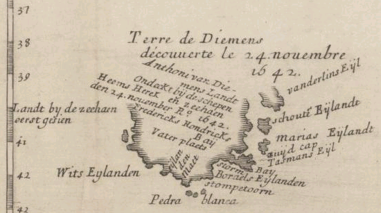
PS: I am also unclear about the "Terre de Diemen". With a name like that is bound to be discovered by Abel Tasman but could it be that that is Tasmania?
[edit on 25/1/2010 by operation mindcrime]
serbsta,
[atsimg]http://files.abovetopsecret.com/files/0e6b93b2f3948715.bmp[/atsimg]
What i can't understand is that they made a detailed map of Antarctica under the ice but failed to depict the entire continent of "New Holland" (Australia)..
They even named the south end (it's relative, i know. But on this map, the south end) New Zealand.
I am working on translating the French.....that will take some time.
Peace
PS: I am also unclear about the "Terre de Diemen". With a name like that is bound to be discovered by Abel Tasman but could it be that that is Tasmania?
[edit on 25/1/2010 by operation mindcrime]
My vote has to go something like this. "hey they lied about our history"
Possibly leading me to believe this is a type of dark age for technology. Perhaps in comparison to the things they could have had we could be considered prehistoric in our technological advancements.
Possibly leading me to believe this is a type of dark age for technology. Perhaps in comparison to the things they could have had we could be considered prehistoric in our technological advancements.
reply to post by operation mindcrime
It seems that Tasman named Tasmania Anthoonij van Diemenslandt.
Here are a couple of maps that may be of interest:
cropped from this one:
[atsimg]http://files.abovetopsecret.com/images/member/351df5c60f95.png[/atsimg]
Full size here:
upload.wikimedia.org...
It's a bit late for me to put all this together so hopefully you guys can glean something.
[edit on 25/1/10 by Chadwickus]
Just one more thing i noticed and then i'll stop...
[atsimg]http://files.abovetopsecret.com/files/3ce7fb878432abea.bmp[/atsimg]
In the green circle you can see they called the north tip "terre des perroquets" which roughly translates as "land of parrots", which was the common name for Australia in those days.
Could it be that these chart makers discovered Australia twice? What i mean, they came across land and charted it, thinking it was Antarctica while they were actually plotting out Australia again?
Peace
If someone has good enough eyes to write out all the French, I would be more then happy to translate for everyone -
Although I do see words like "Glaces" pop up as well (Ice)...So that conflicts a little with the "Terre Des Perroquets" (land of parrots as operation mindcrime mentioned)
Although I do see words like "Glaces" pop up as well (Ice)...So that conflicts a little with the "Terre Des Perroquets" (land of parrots as operation mindcrime mentioned)
Hey guys, just a bit of Australian history for those confused about the naming of "Tasmania" in the map.
It was originally called Van Diemen's Land, and was called this for quite a long time. This is something most Australians should know but outside of Australia most don't know it.
It was originally called Van Diemen's Land, and was called this for quite a long time. This is something most Australians should know but outside of Australia most don't know it.
reply to post by theBFG
At you service...
David Rumsey Collection
You can zoom in to an incredible level!!
Peace
At you service...
David Rumsey Collection
You can zoom in to an incredible level!!
Peace
The text within the continent of Antarctica reads:
Any French people on board?
Something about 9 rivers and the continent being the size of America....
I know i should have paid attention in class.
Peace
[edit on 25/1/2010 by operation mindcrime]
Cercle Polaire
Soupconnees. Le bassin terrestre de leurs fleuves etant plus grand que celui de LaMer glaciale arctique peut contenir
des 60 fleuves aussi considerables que ceux de siberie qui donnent les glaces du nord dont l'ecoulement se fait par les2. Debouquements
de L'islande etdu nouveau Detroit decouvert par les Russes.
Il doit y avoir ici le long et pres des cotes de l'amerique ou des terreins eleves dou s'ecoulent de 9de fleuves qui fournissent
de glaces la mere interieure conjecturee.
Any French people on board?
Something about 9 rivers and the continent being the size of America....
I know i should have paid attention in class.
Peace
[edit on 25/1/2010 by operation mindcrime]
reply to post by operation mindcrime
Thats an interesting speculation. I think its quite plausible that they may have confused some of these southern lands with one another, but if they already had 'New Holland' mapped out (very accurately), then why would a later depiction of it be so inaccurate?
Beats me... good pick up on New Zealand by the way. That could be Tasmania, you have me stumped now even more than I was when writing this thread. Why are they using names which have already been mapped out on New Holland to a landmass which barely resembles earlier charts?
Case of confusion?
Hopefully our French resident can help us with some of the main text on the map so we can get a better idea of what we're looking at, or at least what they thought they were looking at.
I greatly enjoy threads with intellectual value.
You asked for comments and so here is mine. Since you are interested in ancient maps and undiscovered history I'm sure you will enjoy contemplating this theory. Everyone has heard of this place but few know the stories. Plato wrote about it and this is the main reason many people believe it is a real place and not myth. The place I'm referring to is called Atlantis. According to the most credible stories, Atlantis was destroyed for the third and final time about 10,000-12,000 years ago. During this last destruction the whole island sank into the sea.
The Atlanteans were rumored to be the most highly advanced civilization the planet had seen. There is still a good debate about the definition of advanced. Were they referring to spiritually advanced or technologically or both. Most stories agree that Atlantis had an extensive navy for trading and exploring.
There are more stories than there is evidence but these little tidbits are EXTREMELY interesting. The Atlanteans were rumored to be some of the forefathers to the Egyptian AND the Mayan cultures. The stories tell that Atlantis was in trouble and there were few who had advanced notice. The sailed in many different directions trying to save parts of their culture. They settled in India, Egypt, and parts of North and South America.
This could be a possible explanation to the source these ancient cartographers.
How is that for bending the mind just a little more?
new topics
-
What is the white pill?
Philosophy and Metaphysics: 4 minutes ago -
Mike Pinder The Moody Blues R.I.P.
Music: 48 minutes ago -
Putin, Russia and the Great Architects of the Universe
ATS Skunk Works: 3 hours ago -
A Warning to America: 25 Ways the US is Being Destroyed
New World Order: 8 hours ago
top topics
-
President BIDEN's FBI Raided Donald Trump's Florida Home for OBAMA-NORTH KOREA Documents.
Political Conspiracies: 14 hours ago, 31 flags -
A Warning to America: 25 Ways the US is Being Destroyed
New World Order: 8 hours ago, 13 flags -
Is AI Better Than the Hollywood Elite?
Movies: 15 hours ago, 4 flags -
Mike Pinder The Moody Blues R.I.P.
Music: 48 minutes ago, 2 flags -
Maestro Benedetto
Literature: 15 hours ago, 1 flags -
Putin, Russia and the Great Architects of the Universe
ATS Skunk Works: 3 hours ago, 1 flags -
What is the white pill?
Philosophy and Metaphysics: 4 minutes ago, 1 flags
active topics
-
Alternate Electors vs Fake Electors - What is the Difference.
2024 Elections • 122 • : matafuchs -
The Acronym Game .. Pt.3
General Chit Chat • 7755 • : F2d5thCavv2 -
What is the white pill?
Philosophy and Metaphysics • 0 • : kwaka -
Gaza Terrorists Attack US Humanitarian Pier During Construction
Middle East Issues • 59 • : CarlLaFong -
Meadows, Giuliani Among 11 Indicted in Arizona in Latest 2020 Election Subversion Case
Mainstream News • 16 • : Threadbarer -
Democrats Introduce Bill That Will Take Away Donald Trumps Secret Service Protection
2024 Elections • 75 • : TzarChasm -
New whistleblower Jason Sands speaks on Twitter Spaces last night.
Aliens and UFOs • 68 • : baablacksheep1 -
Putin, Russia and the Great Architects of the Universe
ATS Skunk Works • 14 • : RussianTroll -
Truth Social goes public, be careful not to lose your money
Mainstream News • 132 • : matafuchs -
Mike Pinder The Moody Blues R.I.P.
Music • 1 • : RussianTroll