It looks like you're using an Ad Blocker.
Please white-list or disable AboveTopSecret.com in your ad-blocking tool.
Thank you.
Some features of ATS will be disabled while you continue to use an ad-blocker.

The Impossibility of CIT's Flyover... many SHOULD have seen it!
page: 6share:
posted by tezzajw
Can you please explain why the FAA has released a video showing that the alleged plane flew North of Citgo, in contradiction to other flight paths?
posted by Pilgrum
It seems obvious, to me at least, that the raw FDR data was fed into a crude simulation with no correction for the magnetic vs true north orientation (FDR bearings are magnetic, maps are oriented to true north, 11 degrees error). If the map is adjusted to magnetic north, that final FDR bearing takes the plane through the light poles and into the building as reported on a bearing of ~60 degrees which correlates with the damage path through the building as well.
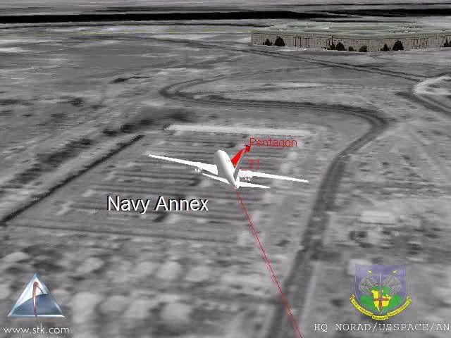
You seem terribly confused. The FAA video tezzajw is referring to is the aircraft flight path released on September 12 2008 by the FAA, showing the Flight 77 flight path over the Naval Annex and north of the Citgo, which does not line up with the flight path through the light poles and does not correlate at all with your 60 degree damage angle into the building. In fact the damage path through the Wedge One 1st floor is quite impossible from over the Naval Annex and north of the Citgo.
FAA confirmed flight path over the Naval Annex and north of the Citgo
An affirmation of the CIT ANC and NOC eyewitness accounts by the FAA
Why is one Federal agency (FAA) releasing data which totally conflicts with official data released by other Federal agencies? Can you explain this apparent division within the Bush Regime? Will this rupture within the defenders of the Official Conspiracy Theory continue to snowball until the entire apologist movement is swallowed up by the quicksand its foundations were laid upon?
Originally posted by SPreston
Why is one Federal agency (FAA) releasing data which totally conflicts with official data released by other Federal agencies?
Are you ready to pony up and support that video as the God's Honest truth? The video that ends with the aircraft slamming into the side of the building?
Or is it more of the CIT/PffT Patented Cherry Picking of Evidence where you'll take a *part* of some sort of event or testimony or eyewitness account and discount the rest of it?
new topics
-
Putin, Russia and the Great Architects of the Universe
ATS Skunk Works: 1 hours ago -
A Warning to America: 25 Ways the US is Being Destroyed
New World Order: 5 hours ago -
President BIDEN's FBI Raided Donald Trump's Florida Home for OBAMA-NORTH KOREA Documents.
Political Conspiracies: 11 hours ago