It looks like you're using an Ad Blocker.
Please white-list or disable AboveTopSecret.com in your ad-blocking tool.
Thank you.
Some features of ATS will be disabled while you continue to use an ad-blocker.

Odd Silver Triangle - Huge!
page: 12
share:
I was wondering If anyone had any clue on what this might be? It just looks like a big triangle in the middle of no where. The coordinates are
33°44'42.52"N and 112°37'59.97"W. Its near Phoenix, Arizona. There is a small dirt road that extends from its top, ive followed it but it only
connects to another road in a small town. Heres a picture.

reply to post by Schmidt1989
Very interesting. What is the source of this photo? Sorry for the one liner.
[edit on 13-7-2008 by space cadet]
Very interesting. What is the source of this photo? Sorry for the one liner.
[edit on 13-7-2008 by space cadet]
It is an abandoned runway/Base from long ago. there are many of them out in the middle of the desert. Back when the air force was a larger force they
had many different bases for training pilots. now all you see is the leftover runways that are scattered around.
That's certainly peculiar. The abandoned runway seems reasonable, but I am sure I've never seen a triangular one. Anyone live in the area?
Very suspect IMO. If there are more of these I would say that there is most likely something under them. You know, 'x' marks the spot.
Here is some basic info on "triangle shaped runways"
Class A layouts were constructed to specifications set by the British Air Ministry in August 1942, the main feature of which was a set of converging strips, each containing a concrete runway for takeoffs and landings, optimally placed at 60 degree angles to each other in a triangular pattern. The longest strip was designated the main strip and aligned southwest to northeast wherever possible, this being chosen to allow aircraft to takeoff and land into the prevailing winds. The other two runways were to allow use when the winds were blowing from other directions. The primary consideration was for operational safety for any type aircraft then in operation or under development, including the U.S. B-29 Superfortress.
The runways were connected by taxiways called a perimeter track, of a standard width of 50 feet (15m). A 30-foot (9m) area was cleared and leveled on either side of the perimeter track. Class A specifications for taxiways set a minimum curve radius of 150 feet measured from the center line for angles greater than 60 degrees and 200 feet (61m) for angles less than 60 degrees. Perimeter track gradients could not exceed 1 in 40 in any direction, and no building could be placed closer than 150 feet from the edge of the track
reply to post by mcgilligan02
Thanks for that well informed and well worded information. All my questions are answered, all my doubts subsided. Good job man!
Thanks for that well informed and well worded information. All my questions are answered, all my doubts subsided. Good job man!
Thanks McGilligan02! I didnt think it was anything bizarre, or area 51-esque, but was still intrigued.
Space Cadet: The image was from Google Earth from my own computer that I uploaded onto Photo Bucket.
Space Cadet: The image was from Google Earth from my own computer that I uploaded onto Photo Bucket.
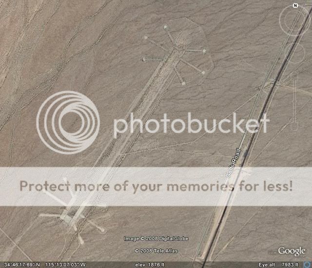
Here's another one for you.
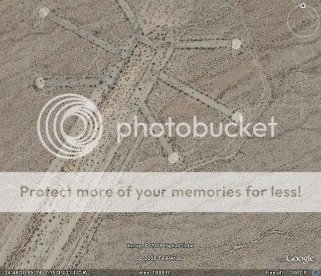
Almost looks like one of the mysterious Mars photos we see now and then.
I think this one started out to be a community catering to pilots and airplane owners and appears to be abandoned.
Whether it is or not, hard to say.
The "hangars" are separated by quite a bit which is what leads me to believe it is/was a private airport/community.
A little closer look.
It does look like it's paved, the runway and taxi strip have a differing color than does the surrounding desert.
Fewer plants growing in the paved area as well.
The asphalt at desert and other airports lose their dark black shade pretty fast and sometimes they can be hard to see from the air.
Location is just off Goff Rd. a half mile or so.
Goff Rd. parallels the main railroad tracks which run between Barstow and San Bernardino, California.
Airport is about 2-3 miles S/E of the Hwy 40 overpass which goes over the RR tracks and is about 3-4 miles S/E of Fenner which appears to be a very small community serving the motoring public.
I stumbled onto it by accident and the symmetrical layout struck me as a little different from most airports I've seen.
new topics
-
Where should Trump hold his next rally
2024 Elections: 2 hours ago -
Shocking Number of Voters are Open to Committing Election Fraud
US Political Madness: 2 hours ago -
Gov Kristi Noem Shot and Killed "Less Than Worthless Dog" and a 'Smelly Goat
2024 Elections: 3 hours ago -
Falkville Robot-Man
Aliens and UFOs: 3 hours ago -
James O’Keefe: I have evidence that exposes the CIA, and it’s on camera.
Whistle Blowers and Leaked Documents: 4 hours ago -
Australian PM says the quiet part out loud - "free speech is a threat to democratic dicourse"...?!
New World Order: 5 hours ago -
Ireland VS Globalists
Social Issues and Civil Unrest: 5 hours ago -
Biden "Happy To Debate Trump"
2024 Elections: 6 hours ago -
RAAF airbase in Roswell, New Mexico is on fire
Aliens and UFOs: 6 hours ago -
What is the white pill?
Philosophy and Metaphysics: 7 hours ago
top topics
-
A Warning to America: 25 Ways the US is Being Destroyed
New World Order: 16 hours ago, 21 flags -
James O’Keefe: I have evidence that exposes the CIA, and it’s on camera.
Whistle Blowers and Leaked Documents: 4 hours ago, 12 flags -
Blast from the past: ATS Review Podcast, 2006: With All Three Amigos
Member PODcasts: 8 hours ago, 11 flags -
Australian PM says the quiet part out loud - "free speech is a threat to democratic dicourse"...?!
New World Order: 5 hours ago, 10 flags -
Biden "Happy To Debate Trump"
2024 Elections: 6 hours ago, 10 flags -
Mike Pinder The Moody Blues R.I.P.
Music: 8 hours ago, 8 flags -
Ireland VS Globalists
Social Issues and Civil Unrest: 5 hours ago, 5 flags -
RAAF airbase in Roswell, New Mexico is on fire
Aliens and UFOs: 6 hours ago, 5 flags -
What is the white pill?
Philosophy and Metaphysics: 7 hours ago, 5 flags -
Putin, Russia and the Great Architects of the Universe
ATS Skunk Works: 11 hours ago, 4 flags
active topics
-
Where should Trump hold his next rally
2024 Elections • 8 • : DontTreadOnMe -
President BIDEN's FBI Raided Donald Trump's Florida Home for OBAMA-NORTH KOREA Documents.
Political Conspiracies • 35 • : Threadbarer -
Candidate TRUMP Now Has Crazy Judge JUAN MERCHAN After Him - The Stormy Daniels Hush-Money Case.
Political Conspiracies • 813 • : WeMustCare -
University of Texas Instantly Shuts Down Anti Israel Protests
Education and Media • 309 • : cherokeetroy -
Remember These Attacks When President Trump 2.0 Retribution-Justice Commences.
2024 Elections • 58 • : WeMustCare -
2024 Pigeon Forge Rod Run - On the Strip (Video made for you)
Automotive Discussion • 8 • : WhitewaterSquirrel -
Gov Kristi Noem Shot and Killed "Less Than Worthless Dog" and a 'Smelly Goat
2024 Elections • 28 • : cherokeetroy -
Shocking Number of Voters are Open to Committing Election Fraud
US Political Madness • 5 • : AwakeNotWoke -
The Acronym Game .. Pt.3
General Chit Chat • 7756 • : bally001 -
RAAF airbase in Roswell, New Mexico is on fire
Aliens and UFOs • 8 • : Skinnerbot
2