It looks like you're using an Ad Blocker.
Please white-list or disable AboveTopSecret.com in your ad-blocking tool.
Thank you.
Some features of ATS will be disabled while you continue to use an ad-blocker.

Plane Swap Over Pennsylvania Flight 93 and his Doppelganger
page: 11
share:
This article deals with the last ten minutes of Flight 93 over Pennsylvania and, encountering the same contradictions, uses the same methods to solve
them. The available accounts on Flight 93 are contradictory concerning its radar status, altitude, and flight path while being in Pennsylvania
airspace. The best explanation: there were two different airplanes.
Plane Swap Over Pennsylvania Flight 93 and his Doppelganger - by Woody Box January 16th, 2006 When beginning my research into the emergency landing of Delta Flight 1989 at Cleveland which resulted in inn.globalfreepress.com... The Cleveland Airport Mystery, I stumbled into a mess of conflicting reports making it impossible to obtain a clear picture of the fate of this airplane. I soon realized, however, that the numerous contradictions could be elegantly solved by postulating the existence of two different airplanes. Now, by a process comparable to the untangling of two twisted phone cords, it was possible to establish a consistent timeline for each of both planes.[BR][BR] This article deals with the last ten minutes of Flight 93 over Pennsylvania and, encountering the same contradictions, uses the same methods to solve them. The available accounts on Flight 93 are contradictory concerning its radar status, altitude, and flight path while being in Pennsylvania airspace. The best explanation: there were two different airplanes. The radar status The geographical position of a flying airplane is determined by its radar echo. Radar stations send out radar waves into the air, the airplane reflects the waves and appears as a spot on the screens of air traffic controllers, allowing them to track it. This is the so-called primary radar.[BR][BR] The radar technology has been improved in recent years. Every commercial airplane has a special device on board, the transponder. Using the radar waves as carrier, the transponder sends detailed data to the ground, particularly the altitude of the airplane. For our purpose, it's sufficient to know this feature of a transponder.[BR][BR] It is a well-known fact that the transponder of UA 93 - like the ones of the other hijacked airplanes - was switched off. But much less known are two further incidents: the transponder was back on at a later point, and the airplane's radar blip vanished from the controller's radar screens several minutes before the crash.[BR][BR] I will designate the three states as follows:[BR][BR] TransponderOn - the transponder is on. Controllers know the position and altitude of the airplane.[BR] PrimaryRadar - the transponder is off. Controllers still know the position of the moving airplane, but not its altitude.[BR] NoRadar - Controllers have lost the airplane's radar echo completely, i.e. they don't know where it is.[BR][BR] The "transition points", i.e. the moments when the radar status changed, are of crucial significance. The first transition is undisputed among all known reports and documents, including the 9/11 Commission Report: At 9:41, UA 93 was over Canton, Ohio, and switched off the transponder, i.e. TransponderOn -> PrimaryRadar; Air Traffic Control was able to track the plane until at least 9:53 (911 Commission Report, p. 29). It is unclear, however, what happened thereafter. Two versions are available:[BR][BR] Transition A: PrimaryRadar -> NoRadar[BR][BR] This transition is confirmed by three sources:[BR][BR] At 9:53, FAA headquarters informed the Command Center that the deputy director for air traffic services was talking to Monte Belger about scrambling aircraft. Then the Command Center informed headquarters that controllers had lost track of United 93 over the Pittsburgh area. Within seconds, the Command Center received a visual report from another aircraft, and informed headquarters that the aircraft was 20 miles northwest of Johnstown. (9/11 Commission Report, page 29/30) [BR][BR] 9:56:56 The track of UAL93 was no longer visible on the PIT (Pittsburgh Airport) radar displays (www.gwu.edu... ) FAA document, scroll down to the timeline at the end) (This document was published in 2005 following a FOIA request)[BR][BR] Cleveland: He s just turned to the east of you. United ninety-three, do you hear Cleveland Center? American ten-sixty and Executive nine fifty-six, we just lost the target on that aircraft. www.thememoryhole.org... Flight 93 Air Traffic Control tape[BR][BR] So the radar echo was lost shortly after 9:53 (911 Commission Report) and was gone until at least 9:57 (FAA document), which makes 9:55 (+- 1 minute) a good and narrow estimation for the transition. In Appendix A I will show that the ATC tape does NOT refer to the last seconds of UA 93 near Shanksville, leading to the conclusion that the tape documents the radar loss we are dealing with here, at 9:55.[BR][BR] Transition B: PrimaryRadar -> TransponderOn [BR][BR] This transition is confirmed by many first-hand sources, too:[BR][BR] "Yes. And then the transponder came back on. We got two hits off the transponder. That s something we ve always wanted to know. Why did the transponder come back on? Because the hijackers had shut it off so that they couldn t be tracked, even though we were still tracking them. Now we were getting an altitude read out on the airplane. I can t remember the precise numbers but it was around 6,400 feet, and then around 5,900 or 5,800 feet. And we re thinking, Oh, you know? Maybe something s happened. Maybe this isn t what we think it is. " (www.team8plus.org... Stacey Taylor, Cleveland controller, on MSNBC ) [BR][BR] Just before ten a.m., Dennis Fritz (air traffic manager) took a call in the control tower at the airport in Johnstown, Pennsylvania. It was the Cleveland "en route" center. A large, suspect aircraft was twenty miles south of Johnstown, descending below six thousand feet and traveling east at a high rate of speed. (Jere Longman: Among the heroes, p. 197)[BR][BR] "As the plane neared Somerset County, air traffic controllers in Cleveland alerted their counterparts at John P. Murtha Johnstown-Cambria County Airport that a plane was about 12 miles away, "heading directly at the airport at about 6,000 feet," ( www.post-gazette.com... Joe McKelvey, Johnstown Airport executive director )[BR][BR] Stacey Taylor describes the return of the transponder directly. She is confirmed by Fritz and McKelvey, who got UA 93's altitude from Cleveland Center - an information impossible to obtain without transponder.[BR][BR] Furthermore, according to Fritz and all other sources, UA 93 approached Johnstown just before 10 o'clock, i.e almost the same time when (a different?) UA 93 was lost from radar screens because it was flying too low. So did both transitions happen on the same plane, in very close succession? This assumption meets big obstacles:[BR][BR] * Transition A (PrimaryRadar-> NoRadar) is not mentioned with one word by Stacey Taylor who was in charge of UA 93.[BR][BR] * Transition B (PrimaryRadar-> TransponderOn) is not mentioned by the 911 Commission Report; quite to the contrary, the text suggests, in quoting pilots who spotted UA 93, that the controllers had no clue where the plane was after 9:53.[BR][BR] * The flight plan change: East of Pittsburgh, UA 93 requested a change of its flight plan, i.e. planned destination. "At 9:55:11 Jarrah dialed in the VHF Omni-directional Range (VOR) frequency for the VOR navigational aid at Washington Reagan National Airport, further indicating that the attack was planned for the nation's capital.." (911 Commission report, p. 457).[BR][BR]
continued
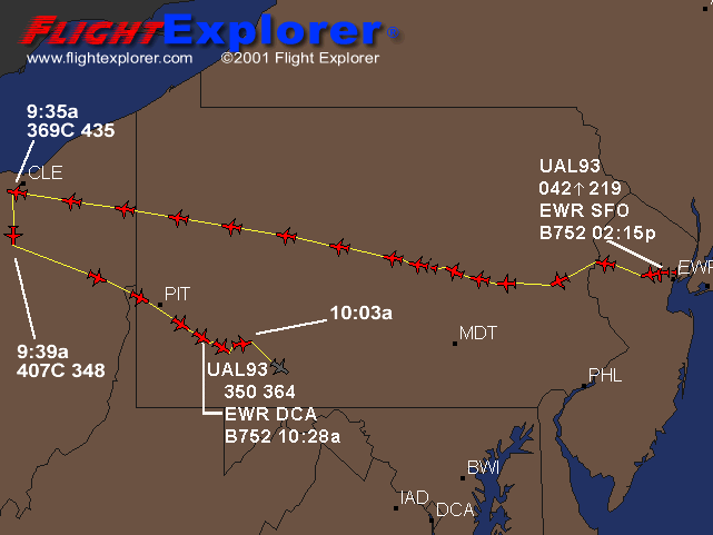
).[BR][BR] One minute later, the FAA approved: At 9:56 a.m., Flight 93 asked the Federal Aviation Administration to change its destination to Reagan
National Airport in Washington. A minute later, the FAA approved, according to Flight Explorer, a firm that tracks such communications. (US News&World
Report, 10/29/01) [BR][BR] At 9:56 a.m., the destination code for the plane in FAA computers was changed from "SFO," the code for San Francisco, to
"DCA," the code for Reagan National Airport in Washington. That indicates an air traffic controller probably changed the destination. Typically,
that is done only when it is requested by the pilots. (St. Petersburg Times, 9/12/01)[BR][BR] So at 9:56, the FAA approved the flight plan change
request of UA 93, at exactly the same time when (the same?) UA 93 was lost from radar. Given this is technically possible - would the FAA controllers
really do that for a plane which they were unable to locate? Or was it a different plane?[BR][BR] In the next two sections it will be shown that the
altitude and flight path data have the same ambivalent pattern as the radar status data, thus putting the hypothesis to rest finally that both
transitions belong to the same plane . [BR][BR][BR][BR] The altitude An intriguing diagram discovered by Frank Levi shows the range of all long-term
radar sites and makes it possible to determine for every geographical point the altitude where a low-flying plane loses radar contact. See Appendix
B.[BR][BR] UA 93 was lost from radar at about 9:55; it was between 10 and 20 miles southeast of Pittsburgh at this moment. In this area, a plane
disappears from radar when it is under 4000 ft roughly. Therefore:[BR][BR] The plane conducting transition A was at about 4000 ft [BR][BR] Bill Wright
was the pilot of a Piper Arrow flying in the Pittsburgh area, and UA 93 crossed his way. Wright relates that the controller from Cleveland (which was
certainly Stacey Taylor) asked him to look for the plane. It's clear from his accounts that she knew UA 93's position, but not the altitude. This is
proof that the plane was in PrimaryRadar status when spotted by Wright. Wright reported an altitude of 8000 ft first
(www.gwu.edu... ) FAA document - scroll down to the end, then 7000 ft (Jere Longman: Among the heroes, see
Appendix C), confirming that the plane was in descent. [BR][BR] This means that only seconds after crossing Wright's path, UA 93 switched the
transponder on: it reappeared on Taylor's screen at an altitude of 6400 ft. Therefore:[BR][BR] The plane conducting transition B was at 6400 ft
[BR][BR] Combining altitude and radar status data makes it even more unlikely that both transitions belong to the same plane. The method is "proof by
contradiction". [BR][BR] Let's first assume that transition A happened before B on the same plane: According to the FAA document, Flight 93 was at
9:56:56 still on NoRadar status, i.e. below 4000 ft. A short time later, it appears with full data set on Stacey Taylor's screen, indicating an
altitude of 6400 ft, descending. In between, it is spotted by Bill Wright. This would mean that Flight 93 performed the following maneuver in one or
(at most) two minutes: it climbs from under 4000 ft to 8000 ft (observed by Bill Wright), stops climbing and begins descending again before switching
on the transponder. This breathtaking maneuver may be theoretically possible, but is sent to the realm of fiction finally if we consider the
geographical data.[BR][BR] The hypothesis that B occurred before A on the same plane is even worse: this would mean that the transponder was switched
on after 9:53, but just two or three minutes later the plane vanished from radar and never re-appeared. But when Dennis Fritz and Joe McKelvey later
got a warning from Cleveland Center "just before 10 a.m.", the transponder was obviously activated. This is a clear contradiction. [BR][BR][BR][BR]
The flight path Until now I have deliberately neglected the geographical position of UA 93 to show that contradictions arise by comparing radar status
and elevation data only. In this section I will show that the position data increase the mess if you try to keep up the (official) hypothesis that
only one plane was involved; just to the contrary, the data fit with the two-plane hypothesis splendidly. [BR][BR] The various illustrations of UA
93's path show basically the same route. Only the last part, when UA 93 re-enters Pennsylvania, is of interest in our context. The path can generally
described like this:[BR][BR] UA 93 enters Pennsylvania over the West Virginia "panhandle", heading southeast. It passes a bit south of Pittsburgh.
Somewhere between Pittsburgh and Somerset, it turns slightly to the right, heading to Johnstown for a little while. But before reaching Johnstown, it
turns south and crashes immediately thereafter. This maneuver results in a flat bulge on the flight path. Every available diagram shows this
bulge.[BR][BR]
Please read the rest at www.team8plus.org...
Please read the rest at www.team8plus.org...

new topics
-
The Great Mosaic of God Unfolding Before Our Eyes
Religion, Faith, And Theology: 5 hours ago -
Silent Weapons
General Conspiracies: 8 hours ago
1