It looks like you're using an Ad Blocker.
Please white-list or disable AboveTopSecret.com in your ad-blocking tool.
Thank you.
Some features of ATS will be disabled while you continue to use an ad-blocker.

McClatchey Photo Analysis
page: 10
share:
Here's my analysis of Val McClatchey's photo of the plume of smoke which was allegedly caused by the crash of Flight 93. This analysis set out to
confirm Killtown's original analysis. I wanted to confirm this independently, and to make sure the measurements were accurate.
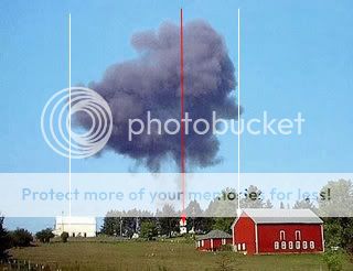
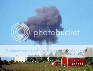
Here's Val McClatchey's photo as published in the Pittsburgh Post-Gazette:
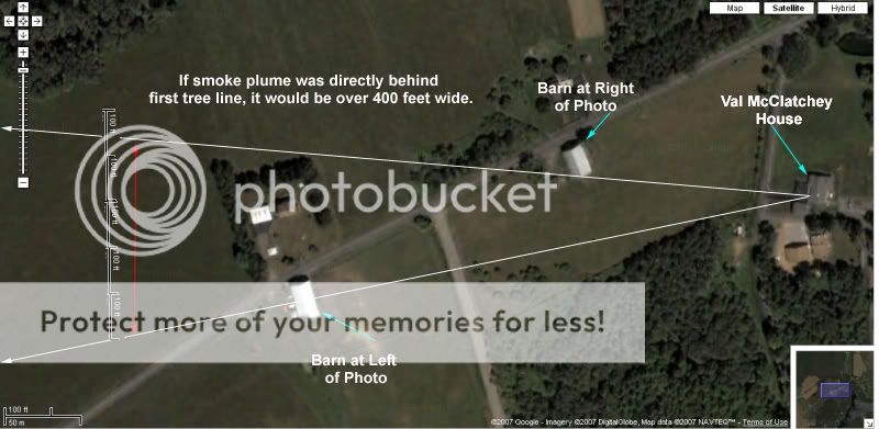
The next set of photos show an overhead view of the area from Google maps. I lined up the edges of the smoke cloud with the landmarks on the ground (the barns). I then extended the lines out towards the crash site:
Close up with maximum zoom:
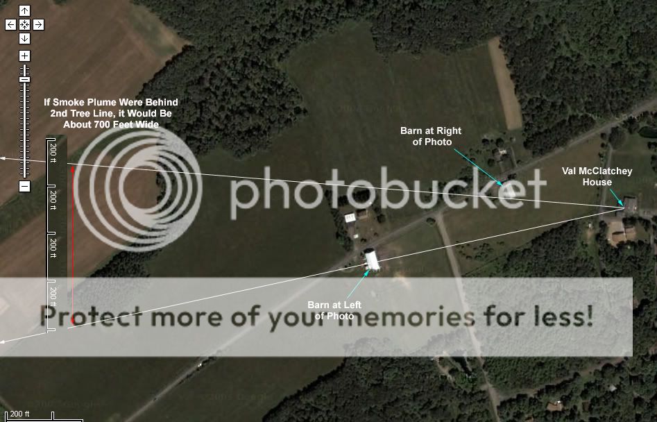
Zoomed out 1 time:
Zoomed Out Again...
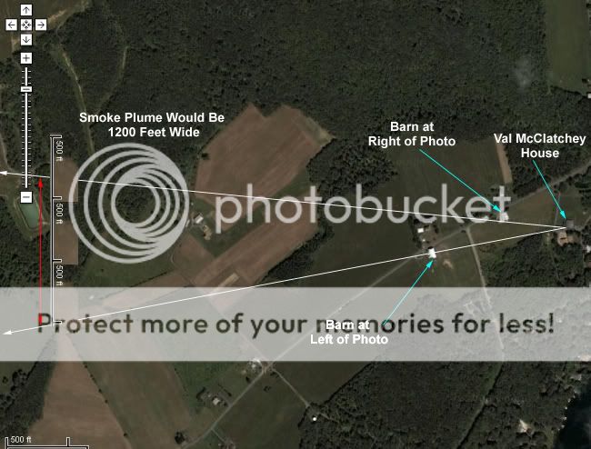
Zoomed out to include McClatchey House and Official Crash Site:
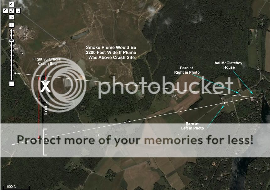
Notice that if the smoke plume was over the crash site, it would have to be about 2200 feet wide.
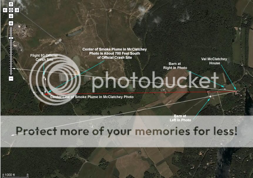
Also, this photo confirms that the center line of the McClatchey photo does not line up with the crash site:
After doing this analysis, I can only conclude that McClatchey faked the photo, or that the smoke plume that she photographed was much closer to her house than the crash site. There's no way a smoke plume from a plane crash would expand to 2200 feet wide in a matter of a few seconds, if at all.
(Also, fyi, I visited the locations to confirm the landmarks' positions relative to each other.)
Again, the credit for this initial find goes 100% to Killtown. I just wanted to confirm Killtown's research.
Here's Val McClatchey's photo as published in the Pittsburgh Post-Gazette:
The next set of photos show an overhead view of the area from Google maps. I lined up the edges of the smoke cloud with the landmarks on the ground (the barns). I then extended the lines out towards the crash site:
Close up with maximum zoom:
Zoomed out 1 time:
Zoomed Out Again...
Zoomed out to include McClatchey House and Official Crash Site:
Notice that if the smoke plume was over the crash site, it would have to be about 2200 feet wide.
Also, this photo confirms that the center line of the McClatchey photo does not line up with the crash site:
After doing this analysis, I can only conclude that McClatchey faked the photo, or that the smoke plume that she photographed was much closer to her house than the crash site. There's no way a smoke plume from a plane crash would expand to 2200 feet wide in a matter of a few seconds, if at all.
(Also, fyi, I visited the locations to confirm the landmarks' positions relative to each other.)
Again, the credit for this initial find goes 100% to Killtown. I just wanted to confirm Killtown's research.

new topics
-
James O’Keefe: I have evidence that exposes the CIA, and it’s on camera.
Whistle Blowers and Leaked Documents: 23 minutes ago -
Australian PM says the quiet part out loud - "free speech is a threat to democratic dicourse"...?!
New World Order: 1 hours ago -
Ireland VS Globalists
Social Issues and Civil Unrest: 1 hours ago -
Biden "Happy To Debate Trump"
Mainstream News: 2 hours ago -
RAAF airbase in Roswell, New Mexico is on fire
Aliens and UFOs: 2 hours ago -
What is the white pill?
Philosophy and Metaphysics: 3 hours ago -
Mike Pinder The Moody Blues R.I.P.
Music: 4 hours ago -
Putin, Russia and the Great Architects of the Universe
ATS Skunk Works: 7 hours ago
0