It looks like you're using an Ad Blocker.
Please white-list or disable AboveTopSecret.com in your ad-blocking tool.
Thank you.
Some features of ATS will be disabled while you continue to use an ad-blocker.

Mars: Crater or hill? Innie or outie?
page: 2share:
Originally posted by bergle
the shadows on the upper right seem to indicate an upward slope from that direction, but if it is depressed in the center shouldnt the upper right of the INNER quadrant be lighter shade?
i vote outie with a domed roof?????
i completely agree with you there... it looks like an outie to me~~
Either way the symmetry of the feature is what is very interesting!!
Next Q:
How was it formed?
Next Q:
How was it formed?
Originally posted by Daedalus3
Next Q:
How was it formed?
Good question!
My little theory is that it is a crater, that filled with sediment of some sort, like volcanic ash, of even water transported sediment. Whatever collected inside the crater, was probably altered by water, made harder by the action. Then the surrounding minerals were eroded away, leaving what we see now.
Look it's a "hill" regardless of what you vote. Here's why.
The shadows of the "dunes" are to the right of the photograph so if the feature were a crater then the shadow should be on the left side of the crater.
Think of a crater as two circular hills coming together, since the shadows are on the right side of the hills, the crater would have the right side of the "left hill" be in shadow. The crater would also have the right side of the "right hill" be in shadow but that side would not exist as a crater is a depression so that side would technically be underneath the undisturbed surface.
Since it is a hill, the left side is shaded like all the other hills in the image.
Originally posted by FreiMaurer
Look it's a "hill" regardless of what you vote. Here's why.
I think we're pretty much in agreement that it is a hill.
Any ideas on how it got to be such an unusual hill?
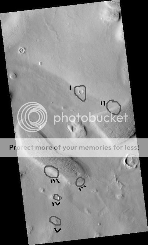
Here is my analysis of the photo, because I can't get the hires due to lack of memory I have to go with the subpar "blow-up" provided on the NASA
site.
North is up.
The area is characterized by a nearly homogenous Albedo (being labeled Red I'm assuming it's in the Red to infrared wavelengths) the texture can be seperated into two units a smooth texture and a mottled texture. Two features dominate the photo and are towards the center of the field of view and are characterized by a higher elevation than the surrounding and the surfaces of these features are the mottled texture. Between them is a similar hill of probably equal height (hard to tell without stereo but suggested by lengths of shadows).
The upper right corner has a same hill feature.
Running diagonally from the upper left 1/3rd to the middle right is a marcation between a lower albedo (south) and a higher albedo to the north. Through irregular locations are craters of various sizes. The craters have a circular rim and the shadows are on the inside left of the rim.
The sun angle is approximately 41 degrees meaning the shadows will be slightly longer than the object is high, because of the steepness of the rim the shadows extend to the edge or beyond the edge of the rim and into the interior of the craters. Suggesting a slope of about 40 degrees (equal to sun angle) which will be referred to as an Angle of repose.
Examining the rises (hills) before mentioned as the two dominant features: The sides of the rises have nearly parallel linear to slightly sinuous rills that run up the slope almost parallel to gradient.
The flat, regions also have linear to slightly sinuous nearly parallel rills but they are local not regional.
The shapes of the rises are rounded.
The fact the shadows barely extend past the slopes suggests that the slopes are at low angles.
Interpretations:
The mottled texture is dominantly caused by the numerous shadows cast by rocks. The rises are probably remnant featuers (meaning not deposited) and the low slope angle suggests their slopes have not been well eroded. The flat broad plains in between due to the sinuous-linear rills is probably a sand sea or dune field or lava flow or both. The rills are probably dunes.
This is plausible because suggesting the area is originally some low rolling hills with eroded features such as boulders, the lower areas are now filled by sand and/or a lava flow and so the boulders are obscured or removed. The sand and/or lava flow would not have traces of boulders themselves.
The strange shapes of the rises seem independent of any depositional activity by sand or dust, and any erosional/depositional characteristics of potential lava.
The higher albedo northern plain seems indicative of lava due to its homogenous and slightly bumpy texture.
The lack of sand within craters on the northern surface suggests that area is deprived of sand...the abundance of it in the southern surface suggests that prevailing winds favors deposition in that region.
There's some more I could probably say about the area, but I want to now direct attention to the oddity in mind.
The circular mound has possible dimensions.
Since each pixel is about 0.29m the circular mound is probably 100 feet high (give or take a bit) and the slope is probably that of a typical drive-way...1% gradient or so...
It looks like an odd mound but it'd probably be seen as a circular hump from the ground.
There is a definate structure to the top but it is obscured by sand//dust. But there is obvious fracturing along the rim by tensional forces since there is nothing there to pull it apart it is probably due to some form of exfoliation. Having been a feature made probably at some shallow depth (there is little uplift on Mars if any) then it surely was shallow, normally such feature on Earth would be long eroded before exfoliation took palce but on Mars billions of years has probably allowed the structure to fall apart in a circular manner.
Phew:
There that's about all I think can be gotten from a picture like that given the context and resolution and etc.
[edit on 27-2-2007 by FreiMaurer]
Concerning theories of water...this area looks very deprived of any water. There are no features I see indicative of flowing water. No streams,
channels, grooves, incisions, nothing.
Reading more about the region (Utopia Planitia) my theories//interpretations seems to be the going trend. I was making wide assumptions simply based on what the region looked like...
The entire region is listed as a former impact crater (huge) and so the area filled with marine sediments or lava (probably the later) which would explain rather well a lot of weird remnant featuers within the basin...and it would support the idea that the high regions are simply not buried by lava or other sediment.
[edit on 27-2-2007 by FreiMaurer]
FreiMaurer
Wow. Thanks for the great replies. Very well contructed replies, I might add.
"Way Above" for that.
Can I zoom all the way in and crop out any of the sections of the BIG image for you to see? I can post them back here in the thread if you like..
Space
Wow. Thanks for the great replies. Very well contructed replies, I might add.
"Way Above" for that.
Can I zoom all the way in and crop out any of the sections of the BIG image for you to see? I can post them back here in the thread if you like..
Space
Originally posted by FreiMaurer
Look it's a "hill" regardless of what you vote. Here's why.
The shadows of the "dunes" are to the right of the photograph so if the feature were a crater then the shadow should be on the left side of the crater.
Not necessarily, like its been said before, if the light is coming from the left side then what you say holds true and it HAS to be a hill.
However if the light were to be coming from the right side then the it could just as well be a crater because the side closer to the light source would be in darkness and the farside would be lit up.
The hill point of view actually makes it more interesting than a crater.
IMO the complexities in such a hill being formed are much more than a crater of this sort.
First, I don't think anyone's theories here are going to work - no one here is considering the differences of Martian geology, people are suggesting
maybe it's some kind of volcanic origin by associating it with similar volcanic features on Earth but it's not...at least hard to say it is...
The following are areas I'd like to see closer because I think they may tell the story best
I - a crater on the boundary line indicated by texture and albedo.
II - a triple boundary line between the two plain units and one dominant rise.
III - the exposed slopes of the rises seen at two different angles
IV - the area between the hill in question and another near to it (include the rims)
V - another similar hill in the plain.
Originally posted by Daedalus3
Originally posted by FreiMaurer
Look it's a "hill" regardless of what you vote. Here's why.
The shadows of the "dunes" are to the right of the photograph so if the feature were a crater then the shadow should be on the left side of the crater.
Not necessarily, like its been said before, if the light is coming from the left side then what you say holds true and it HAS to be a hill.
However if the light were to be coming from the right side then the it could just as well be a crater because the side closer to the light source would be in darkness and the farside would be lit up.
The hill point of view actually makes it more interesting than a crater.
IMO the complexities in such a hill being formed are much more than a crater of this sort.
If the light were coming from the right side the large rises would be lit-up from the right and the rills (dunes) would also be lit-up from the right (their shadows would go left).
Instead their shadows are going right...so the sun angle is to the left.
Furthermore...since the photo is North-up and the time of the photograph is the afternoon and the location is the "Tropic of Cancer" in lattitude...the sun must therefore be somewhere to the direct west of the photo probably around...260 degrees if bearings mattered.
ok.
I have to download the original again.
I'll post the cropped sections over the next 24 hours or so.
All I will be doing is using the jp2 viewer to zoom in, and crop.
Other than that, there will be no image alterations by me.
I have to download the original again.
I'll post the cropped sections over the next 24 hours or so.
All I will be doing is using the jp2 viewer to zoom in, and crop.
Other than that, there will be no image alterations by me.
Yeah my JP2 viewer (like intraview or whatever) just can't handle the memory, or my ram can't...dunno.
Yeah my JP2 viewer (like intraview or whatever) just can't handle the memory, or my ram can't...dunno.
Well, here are the first two.
The export function of the viewer crashes my browser!
section I

section II

These are not zoomed to 100 percent..So I could include some surrounding terrain. These are at about 60 percent.
The export function of the viewer crashes my browser!
section I
section II
These are not zoomed to 100 percent..So I could include some surrounding terrain. These are at about 60 percent.
Originally posted by FreiMaurer
If the light were coming from the right side the large rises would be lit-up from the right and the rills (dunes) would also be lit-up from the right (their shadows would go left).
Instead their shadows are going right...so the sun angle is to the left.
hmmm. yea..
I never really looked at the 'bigger picture'.. quite literally!
Outie it is then!
I want to think those demarcations seen more sharply at a smaller scale is just sand or dirt blown over the rocks, but it's hard to say - there's
some obvious differences such as more speckling to the south which I infer as being more rocks strewn on the surface.
Here are two of the areas from region III that you selected.
IIIa, this is from the End of the plateau like feature

IIIb, this is the selection from the left side of the feature..

This 3rd image is a shot of the terrain, right between the two previous shots, the flat portion of those raised, plateau things. Zoomed to 100 percent. Looks like boulders.
IIIa, this is from the End of the plateau like feature
IIIb, this is the selection from the left side of the feature..
This 3rd image is a shot of the terrain, right between the two previous shots, the flat portion of those raised, plateau things. Zoomed to 100 percent. Looks like boulders.
On one side its a hill, otherwise a crater would have some shadow on its floor to the right.
On the other hand a hill with such a flat top, that would be odd.
On the other hand a hill with such a flat top, that would be odd.
Yeah I think we've conlcuded the tops of the hills are "boulders" but I can't figure out what the plains are - can you take a blow-up like of the
boulders that is in the plain of the photos IIIa/b you can easily tell beyond the 'dune covered slopes" of the hills the plain where it is
relatively mottled and flat...
It's definately seeming like basic hills..but why are they there? Slumping? Remnants from the impact crater they're in?
To see the contact between the plain and hills will give us an idea of composition or at least weathering processes...by idea of composition we'll be limited to pretty much if the surface materials are the same or different.
If you could do a blow-up of the top of the "outtie" then we might get a better idea of what the fracturing on the surface really is.
It could be as simple as the material breaking off and slumping out-ward...maybe this was some kind of volcanic neck that had been exposed over time and as its exposed the walls slump off and form a more concentric but gentle slope around it.
It's possible but maybe unlikely - need a better look.
new topics
-
BIDEN Admin Begins Planning For January 2025 Transition to a New President - Today is 4.26.2024.
2024 Elections: 4 hours ago -
Big Storms
Fragile Earth: 5 hours ago -
Where should Trump hold his next rally
2024 Elections: 8 hours ago -
Shocking Number of Voters are Open to Committing Election Fraud
US Political Madness: 9 hours ago -
Gov Kristi Noem Shot and Killed "Less Than Worthless Dog" and a 'Smelly Goat
2024 Elections: 9 hours ago -
Falkville Robot-Man
Aliens and UFOs: 10 hours ago -
James O’Keefe: I have evidence that exposes the CIA, and it’s on camera.
Whistle Blowers and Leaked Documents: 10 hours ago -
Australian PM says the quiet part out loud - "free speech is a threat to democratic dicourse"...?!
New World Order: 11 hours ago
top topics
-
James O’Keefe: I have evidence that exposes the CIA, and it’s on camera.
Whistle Blowers and Leaked Documents: 10 hours ago, 17 flags -
Australian PM says the quiet part out loud - "free speech is a threat to democratic dicourse"...?!
New World Order: 11 hours ago, 15 flags -
Blast from the past: ATS Review Podcast, 2006: With All Three Amigos
Member PODcasts: 14 hours ago, 14 flags -
Biden "Happy To Debate Trump"
2024 Elections: 12 hours ago, 13 flags -
Ireland VS Globalists
Social Issues and Civil Unrest: 12 hours ago, 10 flags -
Mike Pinder The Moody Blues R.I.P.
Music: 14 hours ago, 9 flags -
BIDEN Admin Begins Planning For January 2025 Transition to a New President - Today is 4.26.2024.
2024 Elections: 4 hours ago, 8 flags -
What is the white pill?
Philosophy and Metaphysics: 14 hours ago, 6 flags -
Shocking Number of Voters are Open to Committing Election Fraud
US Political Madness: 9 hours ago, 6 flags -
Big Storms
Fragile Earth: 5 hours ago, 6 flags
active topics
-
BIDEN Admin Begins Planning For January 2025 Transition to a New President - Today is 4.26.2024.
2024 Elections • 21 • : worldstarcountry -
University of Texas Instantly Shuts Down Anti Israel Protests
Education and Media • 317 • : CriticalStinker -
Ditching physical money
History • 23 • : worldstarcountry -
Australian PM says the quiet part out loud - "free speech is a threat to democratic dicourse"...?!
New World Order • 9 • : ScarletDarkness -
-@TH3WH17ERABB17- -Q- ---TIME TO SHOW THE WORLD--- -Part- --44--
Dissecting Disinformation • 704 • : 777Vader -
Gov Kristi Noem Shot and Killed "Less Than Worthless Dog" and a 'Smelly Goat
2024 Elections • 63 • : GENERAL EYES -
Mood Music Part VI
Music • 3113 • : MRTrismegistus -
One Flame Throwing Robot Dog for Christmas Please!
Weaponry • 12 • : worldstarcountry -
RAAF airbase in Roswell, New Mexico is on fire
Aliens and UFOs • 13 • : Ophiuchus1 -
President BIDEN's FBI Raided Donald Trump's Florida Home for OBAMA-NORTH KOREA Documents.
Political Conspiracies • 40 • : BingoMcGoof