It looks like you're using an Ad Blocker.
Please white-list or disable AboveTopSecret.com in your ad-blocking tool.
Thank you.
Some features of ATS will be disabled while you continue to use an ad-blocker.

Secret Base In Central Pa Region
page: 1share:
Lately ive been seeing very bright fading lights in the town of lockhaven Pa, at night that look like stars but fade away in the sky, they are not
flares there too high, on to my point, there is a very secuded moutain range near lockhaven in a town called renovo pa, which happens to have one of
the nations largest natural gas plants, second ive been seening alot of military trucks and supllies come in and out of the town, there is a guard
station here with trucks but they travel up the road not leading to the guard unit, third this area is perfect for a base loads of moutains and back
roads, and the final thing that makes me belive that there is a base is what ive been seeing in the sky, fighter jets, over the last two days ive see
high altitude dog fights over the lockhaven williamsport region with contrails looping and banking, so you tell me does something sound fishy to you ?
posted are some google earth weird anomlys you tell me what you think
i140.photobucket.com...
Airport ?
i140.photobucket.com...
weird roads ?
i140.photobucket.com...
Possible airbase
more weird stuff to come
Also on google earth if you can find some weird things please post them here look in the lycoming clinton county region in pa
[edit on 26-11-2006 by semperfi221]
i140.photobucket.com...
Airport ?
i140.photobucket.com...
weird roads ?
i140.photobucket.com...
Possible airbase
more weird stuff to come
Also on google earth if you can find some weird things please post them here look in the lycoming clinton county region in pa
[edit on 26-11-2006 by semperfi221]
Please look and see what you can find this would be so cool if you could do this
Don't sweat the lack of responses-
Sunday night is a busy night for people-
and the BIGGEST travel day ALL YEAR...
Anyway- I am from PA,
and I agree with you...
There is no accounting for what you have seen (the activity)
other than some type of base- perhaps connected to the gas.
If there is, as some say, an underground tunnel network,
then I think there may be stop up in Central PA near you...
The airbase shots on google are very convincing...
what is the closest official military prescence around there,
and then the next closest... what branches?
Thanks- and great observations...
Hey-
Any real photos of the stuff you have observed?
The planes? Contrails? The hardward being shipped in? Trucks?
It would be cool to see any of that.
Keep up the snooping!
And i think i found the plant ? is this a hydro dam in PA ???????? ive never seen or heard of this place here is the pic this is also in clinton
county
i140.photobucket.com...
i140.photobucket.com...
[edit on 26-11-2006 by semperfi221]
[edit on 26-11-2006 by semperfi221]
[edit on 26-11-2006 by semperfi221]
i140.photobucket.com...
i140.photobucket.com...
[edit on 26-11-2006 by semperfi221]
[edit on 26-11-2006 by semperfi221]
[edit on 26-11-2006 by semperfi221]
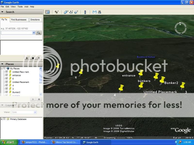
i think ive found proof bunkers posted are what i think are bunkers and there direct GPS locatios
Entrance 41° 9'54.59"N
77°35'48.55"W
Bunkers 41°10'1.76"N
77°36'38.01"W
41° 9'41.31"N
77°35'53.12"W
41° 9'39.83"N
77°36'7.61"W
41° 9'38.40"N
77°35'24.28"W
41° 9'44.37"N
77°35'35.96"W
41° 9'49.27"N
77°35'38.21"W
Use Google Earth
Look to the area north West ? Nothing but trees !!!!!!!!!! Perfect secret base
[edit on 27-11-2006 by semperfi221]
[edit on 27-11-2006 by semperfi221]
Found Another Bunker
41°10'13.56"N
77°37'1.31"W
[edit on 27-11-2006 by semperfi221]
This gives you an idea of what im looking at use what i have provided to make your own conclusions
[edit on 27-11-2006 by semperfi221]
[edit on 27-11-2006 by semperfi221]
41°10'13.56"N
77°37'1.31"W
[edit on 27-11-2006 by semperfi221]
This gives you an idea of what im looking at use what i have provided to make your own conclusions
[edit on 27-11-2006 by semperfi221]
[edit on 27-11-2006 by semperfi221]
Hmm,
I have to say I am from the north central part of pa(cameron county region).This sounds interesting.From hearing what you said could the military activity be from the powerplant located near Quehanna(forgive spelling)/Snowshoe/Moshannon area?Just thought.I think there is a old nuclear powerplant back in the woods at Quehanna.I think it is also fenced off.I have heard alot of stories from my friends hunting back in there like stuff built in the sides of mountains but again take it with a grain of salt.Maybe they are restarting up the powerplant or doing something else with it.
I have to say I am from the north central part of pa(cameron county region).This sounds interesting.From hearing what you said could the military activity be from the powerplant located near Quehanna(forgive spelling)/Snowshoe/Moshannon area?Just thought.I think there is a old nuclear powerplant back in the woods at Quehanna.I think it is also fenced off.I have heard alot of stories from my friends hunting back in there like stuff built in the sides of mountains but again take it with a grain of salt.Maybe they are restarting up the powerplant or doing something else with it.
Giving my topic a bump since no one even wants to talk about it
I live about 30 mins. from Lock Haven,and I never heard anything about this.But then again its a secret base so that would explain not hearing about
it.Keep us updated Semper Fi 221,this sounds very interesting.BTW,were is Fort Indiantown Gap,that is an Army/National guard base for training
exercises and is located somewhere in cental Pa.
Hi
I dont think that the first pic (NewBitmapImage) is an air field, because the trees are way to close to the road for anything other than a light plane...so no military transport or supply runs there.
Without seeing the rest of the pic, those roads (Access, second posted pic) appear to be fire access roads, roads used by firetruckes to get to fires (as im in aust, these appear everywhere).
How ever, the pic of the dam looks like it could generate power, and something could be said if it is generating power but not mentioned, also the mention of a nuclear power plant is intreaging.
Keep us posted, possibly some pics of the trucks or strangeness you are seeing?
Cheers
Another Entrance? as it apears to lead to nothing but trees?
Try this base locator you might find some information.
www.local.com...
[edit on 3-12-2006 by ULTIMA1]
www.local.com...
[edit on 3-12-2006 by ULTIMA1]
looks to me like logging activity - PS if you are close to it , get OTG photographs
I live about 18 miles southwest of LockHaven, just on the center county line of Lamar, I havent witnessed any recent activity in the skies but I
havent really been looking either. I will start to pay attention on this side of lockhaven from now and report anything i find in this thread.
Now i have heard of a secret U.S. Base north of renovo, Now i used to witness a lot of harrier activity when i was growing up in this house, they used to fly as low as possible just above the tree line. Also have you heard about Project Ketch just south of renovo? Apparently they set off a nuclear bomb to create a cavity to collect natural gas. My sister a current cancer survivor swears that project is why she got cancer. Anyhow I have also heard that Ketch was a project to use nuclear weapons to build underground bases. A lot of misinformation out there so i'm not sure what to think.
Now i have heard of a secret U.S. Base north of renovo, Now i used to witness a lot of harrier activity when i was growing up in this house, they used to fly as low as possible just above the tree line. Also have you heard about Project Ketch just south of renovo? Apparently they set off a nuclear bomb to create a cavity to collect natural gas. My sister a current cancer survivor swears that project is why she got cancer. Anyhow I have also heard that Ketch was a project to use nuclear weapons to build underground bases. A lot of misinformation out there so i'm not sure what to think.
Well Hmm A nuke wow, anyone else have any information, this is shaping up to be cool, i just bought a new vid camera, when i was a kid in bradford
county jets used to make low passes all the time, my grandparents would get pissed becasue the rumble would knock stuff off the walls i rember a jet
piolet waving to me once thats how low they were one time the were so low the water in my grand parents pond rippled
Originally posted by JackJuice
Apparently they set off a nuclear bomb to create a cavity to collect natural gas.
what the sam hell ????
they may have proposed such a mad cap scheme - back when people thought that nuclear munitions were a " perfect answer " to a whole range of " problems "
but i would like to see a cite that confirms they actually did it
just from an engineering POV , carving a gas storage cavern with a nuclear munition would lead to radio isotopes being introduced into the gas supply
a stupid idea - even for the group that once proposed digging cross country canals with nukes
A lot of misinformation out there so i'm not sure what to think.
you said it
Originally posted by semperfi221
Well Hmm A nuke wow, anyone else have any information, this is shaping up to be cool, i just bought a new vid camera, when i was a kid in bradford county jets used to make low passes all the time, my grandparents would get pissed becasue the rumble would knock stuff off the walls i rember a jet piolet waving to me once thats how low they were one time the were so low the water in my grand parents pond rippled
Yeah they can get pretty low, i couldnt see the pilots because they were generally right over top of me but when i waved to them usually they would dip their wing at me. Now as far as project Ketch goes here is some info
Source
An interesting caper in the 1967-69 time frame was Project Ketch. This venture by Columbia Gas and US Atomic Energy Commission proposed the detonation of nuclear devices for the formation of underground caverns for the storage of natural gas. The project was part of Project Gasbuggy in the Plowshares Program (peaceful uses of atomic energy). The facility was to be sited near Renovo in Clinton County. Due in large part to public uproar, the project was eventually canceled.
Some people think they still went through with it. Here is some more info about ketch
source
The Pennsylvania location would allow the AEC
to demonstrate the purported scientific and practical feasibility of Plowshare
ideas. Importantly, such a location needed to be marginal: marginality of the
place and its people was a necessary condition for Project Ketch to be realized.
A discourse of economic development was significant for constructing margin-
ality: a human and physical landscape could be made worthy of a nuclear blast
by configuring the selected ground zero and its people as economically needy
and socially underdeveloped.
Apparently they don't think very highly of us. Also there is a crude map in that last source of the proposed ground zero. I remember seeing a site a few years ago that showed a lot of the constructions so i attempted to find Ground Zero with google earth I'll give you the coordinates and you can tell me what you think
Lat 41.192641 Lon -77.883801 Let me know what ya think, I'm still looking for anything i could construe as a base
new topics
-
Big Storms
Fragile Earth: 30 minutes ago -
Where should Trump hold his next rally
2024 Elections: 3 hours ago -
Shocking Number of Voters are Open to Committing Election Fraud
US Political Madness: 3 hours ago -
Gov Kristi Noem Shot and Killed "Less Than Worthless Dog" and a 'Smelly Goat
2024 Elections: 4 hours ago -
Falkville Robot-Man
Aliens and UFOs: 4 hours ago -
James O’Keefe: I have evidence that exposes the CIA, and it’s on camera.
Whistle Blowers and Leaked Documents: 5 hours ago -
Australian PM says the quiet part out loud - "free speech is a threat to democratic dicourse"...?!
New World Order: 6 hours ago -
Ireland VS Globalists
Social Issues and Civil Unrest: 6 hours ago -
Biden "Happy To Debate Trump"
2024 Elections: 7 hours ago -
RAAF airbase in Roswell, New Mexico is on fire
Aliens and UFOs: 7 hours ago
top topics
-
A Warning to America: 25 Ways the US is Being Destroyed
New World Order: 17 hours ago, 21 flags -
Blast from the past: ATS Review Podcast, 2006: With All Three Amigos
Member PODcasts: 9 hours ago, 13 flags -
James O’Keefe: I have evidence that exposes the CIA, and it’s on camera.
Whistle Blowers and Leaked Documents: 5 hours ago, 12 flags -
Biden "Happy To Debate Trump"
2024 Elections: 7 hours ago, 12 flags -
Australian PM says the quiet part out loud - "free speech is a threat to democratic dicourse"...?!
New World Order: 6 hours ago, 12 flags -
Mike Pinder The Moody Blues R.I.P.
Music: 9 hours ago, 8 flags -
What is the white pill?
Philosophy and Metaphysics: 9 hours ago, 6 flags -
Shocking Number of Voters are Open to Committing Election Fraud
US Political Madness: 3 hours ago, 5 flags -
Ireland VS Globalists
Social Issues and Civil Unrest: 6 hours ago, 5 flags -
RAAF airbase in Roswell, New Mexico is on fire
Aliens and UFOs: 7 hours ago, 5 flags
active topics
-
Candidate TRUMP Now Has Crazy Judge JUAN MERCHAN After Him - The Stormy Daniels Hush-Money Case.
Political Conspiracies • 817 • : RazorV66 -
Gov Kristi Noem Shot and Killed "Less Than Worthless Dog" and a 'Smelly Goat
2024 Elections • 31 • : Sookiechacha -
Big Storms
Fragile Earth • 5 • : nugget1 -
"We're All Hamas" Heard at Columbia University Protests
Social Issues and Civil Unrest • 290 • : TheWoker -
Post A Funny (T&C Friendly) Pic Part IV: The LOL awakens!
General Chit Chat • 7137 • : PorkChop96 -
Massachusetts Drag Queen Leads Young Kids in Free Palestine Chant
Social Issues and Civil Unrest • 21 • : ToneD -
Biden "Happy To Debate Trump"
2024 Elections • 49 • : TheMisguidedAngel -
Where should Trump hold his next rally
2024 Elections • 13 • : Edumakated -
Shocking Number of Voters are Open to Committing Election Fraud
US Political Madness • 6 • : marg6043 -
University of Texas Instantly Shuts Down Anti Israel Protests
Education and Media • 312 • : marg6043