It looks like you're using an Ad Blocker.
Please white-list or disable AboveTopSecret.com in your ad-blocking tool.
Thank you.
Some features of ATS will be disabled while you continue to use an ad-blocker.

I don’t know what this is, but it’s HUGE!
page: 119
share:
I don’t know what this is, but it’s HUGE! I was looking at the NOAA and NRL web sites tracking hurricane Dorian.
I’ve noticed that the last 2 days this counter clockwise rotation has become a little more organized.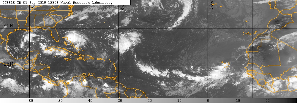
It's in the upper part of the frame in the middle. If you follow the link, you can watch a video of it spinning.
www.nrlmry.navy.mil.../atlantic/tropics/ir&ANIM_TYPE =Instant&DISPLAY=Single
The sea temp are around 83 degrees in that area www.nodc.noaa.gov...
and the wind maps show counter clock wise rotation at only 17 to 5 mph. www.windy.com...,-49.382,5,m:eRNafbW
Maybe it's just a very big low pressure system.
Has anyone ever seen anything this big before?
IF it turns into a hurricane, it may be the biggest I’ve ever seen!
edit on V412019Mondayam30America/ChicagoMon, 02 Sep 2019 00:41:55 -05001 by Violater1 because: srtyh
a reply to: Violater1
www.nrlmry.navy.mil...
When you go here, the only button you need to push is "ANIMATE." Then INSTANT from the drop down menu.
www.nrlmry.navy.mil...
When you go here, the only button you need to push is "ANIMATE." Then INSTANT from the drop down menu.
edit on V492019Mondayam30America/ChicagoMon, 02 Sep 2019 00:49:39 -05001 by Violater1 because: 'pRIJ
Perpendicular to Virginia? It does look cool and I know little about meteorology but as I understand it the water isn't warm enough in that part of
the ocean to facillitate climate conditions necessary for a hurricane to form.

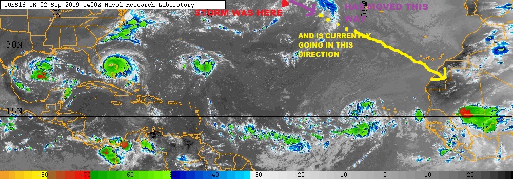
You talking about the low pressure center top row, 3rd block in from the right?
That was over the Hudson Bay region a few days ago, MI got a nice line of fast moving thunderstorms from the tail end of it when it moved east.
Edit: Whoops, my sense of continental scale is way off, that one that came through here went much, much further north. Had to check the stitched Atlantic map to be sure, but the one you're talking about is just a mid-Atlantic low. Not nearly organized enough to be an extratropical storm. It's like the difference between a low pressure system moving through the Midwest, and a Derecho moving through the Midwest.
That was over the Hudson Bay region a few days ago, MI got a nice line of fast moving thunderstorms from the tail end of it when it moved east.
edit on 9/2/2019 by Nyiah because: (no reason given)
Edit: Whoops, my sense of continental scale is way off, that one that came through here went much, much further north. Had to check the stitched Atlantic map to be sure, but the one you're talking about is just a mid-Atlantic low. Not nearly organized enough to be an extratropical storm. It's like the difference between a low pressure system moving through the Midwest, and a Derecho moving through the Midwest.
edit on 9/2/2019 by
Nyiah because: (no reason given)
originally posted by: Nyiah
You talking about the low pressure center top row, 3rd block in from the right?
That was over the Hudson Bay region a few days ago, MI got a nice line of fast moving thunderstorms from the tail end of it when it moved east.
Edit: Whoops, my sense of continental scale is way off, that one that came through here went much, much further north. Had to check the stitched Atlantic map to be sure, but the one you're talking about is just a mid-Atlantic low. Not nearly organized enough to be an extratropical storm. It's like the difference between a low pressure system moving through the Midwest, and a Derecho moving through the Midwest.
It's about 40W and 40N. When you watch the video it's very noticeable. I see what your saying about it being extra-tropical, but if it follows the warm water temps down towards the tropics, this could be epic.
a reply to: Violater1
I have the feeling that with the way things are going on our poor ole mistreated earth storms...hurricanes, monsoons etc are just going to continue to get bigger, bigger and worse than anything in history...except for when the earth was going through its formation....
I have the feeling that with the way things are going on our poor ole mistreated earth storms...hurricanes, monsoons etc are just going to continue to get bigger, bigger and worse than anything in history...except for when the earth was going through its formation....
a reply to: ScrazzleBerry3
We right inline for the historical average.. 2012-2015 seasons were below average. Last couple have been above.
We right inline for the historical average.. 2012-2015 seasons were below average. Last couple have been above.
a reply to: Violater1
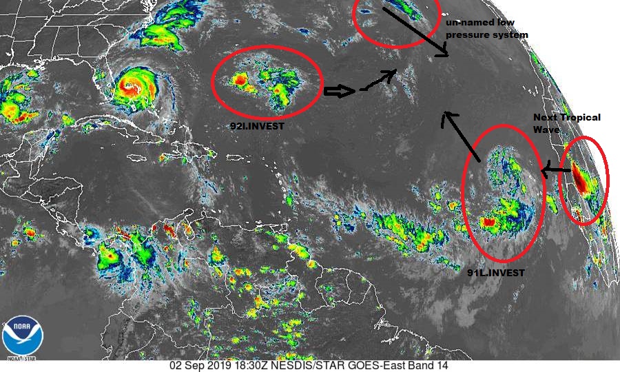
I think it's an extratropical low that just spun up of all the convection that came off the Cape Verdes in the last few weeks, what's often called 'the freight train'. Historically, around the end of September, the CV storms decrease and things form in the lower Caribbean. I think we have three Invests working now in the Atlantic/Caribbean basin.
Very tight system that you outlined! I have been watching the Atlantic/Carib very closely in the past couple of weeks, and I didn't see it. Well done! It almost ....... almost looks like a closed circulation. Very cool! A fish storm.
Have family in P.E.I. and go up every year., Cavendish/N.Rustico farm. Just came back mid August. They were catching striped bass for the first time
in 50 years up there. The Tuna are basically "on vacation" somewhere else, but the lobster catch was amazing for most (Ended 1 July for that part of
the island). The water temperature was in mid 70's F.
I have been going up there every year since 1968. Changes... Changes...
Should note that some of the family are lobster fisherman.. 500+ traps. They are very experienced and said: The lobsters this year were passing through, thus the good catch. They are on their way to cooler waters, North, way past Newfoundland and heading toward Greenland and Iceland.
Hoping not a big trend because it would cost a great deal to fish them in waters like that environment. Lobsters migrate up and down the East coast but this is extreme.
I have been going up there every year since 1968. Changes... Changes...
edit on 2-9-2019 by charlyv because: spelling , where
caught
Should note that some of the family are lobster fisherman.. 500+ traps. They are very experienced and said: The lobsters this year were passing through, thus the good catch. They are on their way to cooler waters, North, way past Newfoundland and heading toward Greenland and Iceland.
Hoping not a big trend because it would cost a great deal to fish them in waters like that environment. Lobsters migrate up and down the East coast but this is extreme.
edit on 3-9-2019 by charlyv because: spelling , where caught
Looks to me like a low pressure circulation. I see them often over the mainland US when a low pressure front is coming through. Since I live on the
Gulf coast of Florida, those other two wannabe hurricanes bother me.
edit on 3-9-2019 by eManym because: (no reason given)
GOOD NEWS FOR MOST!
Dorian Downgraded to a Category 3 Storm: www.foxnews.com...
(Bad News for the HYPEsters and Doom-lovers)
Dorian Downgraded to a Category 3 Storm: www.foxnews.com...
(Bad News for the HYPEsters and Doom-lovers)
new topics
-
Israeli strikes on southern Gaza city of Rafah kill 22, mostly children, as US advances aid package
Middle East Issues: 3 hours ago -
Really Unexplained
Paranormal Studies: 8 hours ago -
The Vaccine Injured
Medical Issues & Conspiracies: 8 hours ago -
Leading Surgeon from Al-Shifa Hospital Dies in Israeli Custody
Middle East Issues: 11 hours ago
top topics
-
Zionists of ATS assemble
Political Issues: 15 hours ago, 12 flags -
Leading Surgeon from Al-Shifa Hospital Dies in Israeli Custody
Middle East Issues: 11 hours ago, 6 flags -
The Vaccine Injured
Medical Issues & Conspiracies: 8 hours ago, 4 flags -
Really Unexplained
Paranormal Studies: 8 hours ago, 4 flags -
Israeli strikes on southern Gaza city of Rafah kill 22, mostly children, as US advances aid package
Middle East Issues: 3 hours ago, 2 flags
active topics
-
Zionists of ATS assemble
Political Issues • 102 • : Zanti Misfit -
SHORT STORY WRITERS CONTEST -- April 2024 -- TIME -- TIME2024
Short Stories • 33 • : DontTreadOnMe -
Leading Surgeon from Al-Shifa Hospital Dies in Israeli Custody
Middle East Issues • 43 • : RAY1990 -
Candidate TRUMP Now Has Crazy Judge JUAN MERCHAN After Him - The Stormy Daniels Hush-Money Case.
Political Conspiracies • 1174 • : YourFaceAgain -
Israeli strikes on southern Gaza city of Rafah kill 22, mostly children, as US advances aid package
Middle East Issues • 82 • : Boogerpicker -
The Acronym Game .. Pt.3
General Chit Chat • 7792 • : RAY1990 -
UN Estimates Rebuilding Gaza Will Cost Up To 40 Billion Dollars
Middle East Issues • 82 • : Plugit -
EPA sues San Francisco for dumping billions of gallons of sewage into Pacific Ocean
US Political Madness • 18 • : YouSir -
Shocking moment four men 'try to force Jewish pedestrian into car boot' in North London
Breaking Alternative News • 86 • : RAY1990 -
Doctors Predict Epidemic of Prion Brain Diseases From mRna Jab
Health & Wellness • 66 • : Mythain
19