It looks like you're using an Ad Blocker.
Please white-list or disable AboveTopSecret.com in your ad-blocking tool.
Thank you.
Some features of ATS will be disabled while you continue to use an ad-blocker.

Huge, Breaking And Alarming News About Recent 4.6 and 4.8 Wyoming Earthquakes
page: 1share:
Please read my timeline since I think this is very important! This here is a little bit of science and conspiracy intertwined. But I think I am
really on to something here. This is all my own work.
What I am aiming to prove is that there is some funny business happening in the Wyoming Jack Creek basin. By funny business I mean possible volcanic activity. And why is the name of that Nov 2015 ranch that developed a canyon like crack still unnamed to this day? I will keep trying to find the name. But I would have to say, that with my research it is a 99% probability that it is the Little Jennie Ranch.
___________________________________________________________________________________________________
Timeline:
-Sept 2015 Little Jennie Ranch in Wyoming put up for sale (Looks almost like an ancient caldera)
-Nov 2015 Huge Mysterious Gash Opens up on Wyoming Ranch (unnamed)
-July/Aug 2016 Little Jennie ranch area closed for fires (Jack Creek basin)
-Aug 27, 2016 Little Jennie ranch is epicenter of a 4.6 and 4.8 EQ.
__________________________________________________________________________________________________
The whole area around Little Jennie ranch has been non stop fires.
Cliff Creek Closures
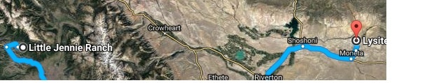
This is where the Little Jennie Ranch is.
Cliff Creek Fire Update
_____________________________________________________________________________________________________
The hunting company's ( SNS Outfitter & Guides) staff found the huge Nov 2015 crack. And they are located in Jackson hole 30 min from the Little Jennie Ranch.
That Nov 2015 crack that looks like a canyon was said by MANY MANY scientists to not have been caused by an EQ
Contrary to what many think, there were 2 earthquakes on 8-27-16 at the same exact time (only 1 sec apart) but in 2 close but different spots. You can check this out on RSOE Edis.
The 4.8 landed right on top of the Little Jennie Ranch. You can see this by zooming in on the RSOE EDIS ALERT MAP - click here.
MagnitudeM 4.8
Date-Time [UTC] 27th August 2016 08:47:47 PM
Coordinate 43° 13.794,110° 18.774
Depth 9.99 km [6.21 miles]
Location 11.00 km [6.84 miles] to Bondurant,North-America
MagnitudeM 4.6
Date-Time [UTC] 27th August 2016 08:47:46 PM
Coordinate 43° 15.600,110° 12.000
Depth 5 km [3.11 miles]
Location 23.00 km [14.29 miles] to Bondurant,North-America
_____________________________________________________________________________________________________
This is the little Jennie Ranch area that was closed for the fires and is EQ ground zero and almost looks like a fricken old caldera.
This is the crack that developed in Nov 2015 on an unnamed ranch that a HUGE number of scientists swore up and down was not caused by an EQ. I am 99% certain that this was the Little Jennie Ranch and ground zero for the 2 Aug 27th EQ, and July/Aug fires.
I would still like to prove 100% that this is the Little Jennie ranch. Help would be appreciated.
What I am aiming to prove is that there is some funny business happening in the Wyoming Jack Creek basin. By funny business I mean possible volcanic activity. And why is the name of that Nov 2015 ranch that developed a canyon like crack still unnamed to this day? I will keep trying to find the name. But I would have to say, that with my research it is a 99% probability that it is the Little Jennie Ranch.
___________________________________________________________________________________________________
Timeline:
-Sept 2015 Little Jennie Ranch in Wyoming put up for sale (Looks almost like an ancient caldera)
-Nov 2015 Huge Mysterious Gash Opens up on Wyoming Ranch (unnamed)
-July/Aug 2016 Little Jennie ranch area closed for fires (Jack Creek basin)
-Aug 27, 2016 Little Jennie ranch is epicenter of a 4.6 and 4.8 EQ.
__________________________________________________________________________________________________
The whole area around Little Jennie ranch has been non stop fires.
Cliff Creek Closures
This is where the Little Jennie Ranch is.
The Bridger-Teton National Forest Emergency Area Closure, Order #04-03-562 went into effect Friday, August 5. This modification to the closure allows public access to areas WEST of Granite Creek. Burned areas, Granite Creek Campgrounds, Granite Hot Springs and numerous forest trails remain closed. The area closure also encompasses everything east of Granite Creek, the ridge north of Granite Hot Springs within the Gros Ventre Wilderness, and easterly to the Sawtooths and south along the Shoal Creek Wilderness Study Area to Jack Creek Basin and the private land boundary.
Cliff Creek Fire Update
_____________________________________________________________________________________________________
The hunting company's ( SNS Outfitter & Guides) staff found the huge Nov 2015 crack. And they are located in Jackson hole 30 min from the Little Jennie Ranch.
That Nov 2015 crack that looks like a canyon was said by MANY MANY scientists to not have been caused by an EQ
Contrary to what many think, there were 2 earthquakes on 8-27-16 at the same exact time (only 1 sec apart) but in 2 close but different spots. You can check this out on RSOE Edis.
The 4.8 landed right on top of the Little Jennie Ranch. You can see this by zooming in on the RSOE EDIS ALERT MAP - click here.
MagnitudeM 4.8
Date-Time [UTC] 27th August 2016 08:47:47 PM
Coordinate 43° 13.794,110° 18.774
Depth 9.99 km [6.21 miles]
Location 11.00 km [6.84 miles] to Bondurant,North-America
MagnitudeM 4.6
Date-Time [UTC] 27th August 2016 08:47:46 PM
Coordinate 43° 15.600,110° 12.000
Depth 5 km [3.11 miles]
Location 23.00 km [14.29 miles] to Bondurant,North-America
_____________________________________________________________________________________________________
This is the little Jennie Ranch area that was closed for the fires and is EQ ground zero and almost looks like a fricken old caldera.
This is the crack that developed in Nov 2015 on an unnamed ranch that a HUGE number of scientists swore up and down was not caused by an EQ. I am 99% certain that this was the Little Jennie Ranch and ground zero for the 2 Aug 27th EQ, and July/Aug fires.
I would still like to prove 100% that this is the Little Jennie ranch. Help would be appreciated.
edit on 28-8-2016 by elouina because: (no reason given)
Very interesting. You've put in some work on this OP well done.
Hoping someone can shed some light on this S+F
Hoping someone can shed some light on this S+F
originally posted by: elouina
I would still like to prove 100% that this is the Little Jennie ranch. Help would be appreciated.
It is not Little Jennie Ranch ...
Mysterious huge crack developing in Wyoming
The crack, which is about 50 yards wide, is located 40 miles south of Ten Sleep.
Added later, new information has been found linking the Little Jennie Ranch
Good good good, and thank you. So we removed this aspect that I was still not 100% certain of. So this still leaves:
-the listing of little Jennie ranch for sale Sept 2015
-the fires near there July/aug 2016
-the 2 EQ Aug
But also that hunting business that found the crack in Nov 2015 was only 30 min away from the little Jennie ranch which also offers hunting. I am going to try and confirm this location. And actually the hunters first noticed that crack in Oct 2015. Now only one month after the for sale notice of the LJ Ranch. Plus, we still don't have the ranch name.
originally posted by: coffeetalk
originally posted by: elouina
I would still like to prove 100% that this is the Little Jennie ranch. Help would be appreciated.
It is not Little Jennie Ranch ...
Mysterious huge crack developing in Wyoming
The crack, which is about 50 yards wide, is located 40 miles south of Ten Sleep.
Good good good, and thank you. So we removed this aspect that I was still not 100% certain of. So this still leaves:
-the listing of little Jennie ranch for sale Sept 2015
-the fires near there July/aug 2016
-the 2 EQ Aug
But also that hunting business that found the crack in Nov 2015 was only 30 min away from the little Jennie ranch which also offers hunting. I am going to try and confirm this location. And actually the hunters first noticed that crack in Oct 2015. Now only one month after the for sale notice of the LJ Ranch. Plus, we still don't have the ranch name.
edit on 28-8-2016 by elouina because: (no reason given)
Edited later to add, new info has been found to link the Little Jennie ranch.
reply to: coffeetalk
Wait a minute. They said about 40 miles south of Ten Sleep Wy. Walking distance is 88 miles south between LJ Ranch and Ten sleep. This is off by only 40 or so miles. We are not off the hook yet.
reply to: coffeetalk
Wait a minute. They said about 40 miles south of Ten Sleep Wy. Walking distance is 88 miles south between LJ Ranch and Ten sleep. This is off by only 40 or so miles. We are not off the hook yet.
edit on 28-8-2016 by elouina because: (no reason given)
originally posted by: pheonix358
a reply to: elouina
There was one EQ that had two reports generated. One by USGS and the other by EMSC.
This is how RSOE reports them.
P
Ok this is a learning experience here. But still the epicenter is either the LJ ranch or extremely close. The ranch is over 3,000 acres.
originally posted by: coffeetalk
originally posted by: elouina
I would still like to prove 100% that this is the Little Jennie ranch. Help would be appreciated.
It is not Little Jennie Ranch ...
Mysterious huge crack developing in Wyoming
The crack, which is about 50 yards wide, is located 40 miles south of Ten Sleep.
Ok, now I have a link that says near Lysite wy which is pretty darn close to the LJ ranch. And actually the LJ ranch is right off to the left side of Lysite
Bingo!
Giant crack opens up in Wyoming
Now from what I read this is gov owned land in the middle of a private ranch.
ARTICLE SAYS NEAR LYSITE
edit on 28-8-2016 by elouina because: (no reason given)
Now from what I read this is gov owned land in the middle of a private ranch.
I saw that too, and it piqued my curiosity more than the original landslide story did. Is that a normal situation: a Government-owned parcel of land within a privately-owned piece? Does anyone know what the particular circumstances are in this case?
originally posted by: lacrimoniousfinale
Now from what I read this is gov owned land in the middle of a private ranch.
I saw that too, and it piqued my curiosity more than the original landslide story did. Is that a normal situation: a Government-owned parcel of land within a privately-owned piece? Does anyone know what the particular circumstances are in this case?
They're normally for seismological monitoring sites aren't they? Not just placed randomly but where they're most likely to pick up any activity.
originally posted by: lacrimoniousfinale
Now from what I read this is gov owned land in the middle of a private ranch.
I saw that too, and it piqued my curiosity more than the original landslide story did. Is that a normal situation: a Government-owned parcel of land within a privately-owned piece? Does anyone know what the particular circumstances are in this case?
This is exactly what I was thinking. Perhaps the gov owns the mountain areas? Or is this something shadier? Maybe they have known something all along. Maybe we can pull up some geological info on this site now that we have it?
I am still a bit shell shocked that I found that mention of the ranch being near Lysite. Yeah I have my conspiracies but this may be a lot more this time.
What bothers me just as much as the gov owned land is the exact location not being available to the public. It is gov owned, right? Then we the people own it.
edit on 28-8-2016 by elouina because: (no reason given)
originally posted by: Imagewerx
originally posted by: lacrimoniousfinale
Now from what I read this is gov owned land in the middle of a private ranch.
I saw that too, and it piqued my curiosity more than the original landslide story did. Is that a normal situation: a Government-owned parcel of land within a privately-owned piece? Does anyone know what the particular circumstances are in this case?
They're normally for seismological monitoring sites aren't they? Not just placed randomly but where they're most likely to pick up any activity.
Ah ha! I think we have an answer. Now why no exact location in all the news reports. Near here, below there... Etc... We need the geographical info.
Since you would have to cross personal property to get to this, can anyone do a fly over?
Why is it important to know what specific property is involved?
originally posted by: 123143
Why is it important to know what specific property is involved?
If it was this parcel, it would be the area of the july/aug 2016 fires, the Oct 2015 cracks and the Aug 4.8 EQ. All this leads to a good chance there is more going on then we were previously aware.
Plus a slew of scientists said the Oct 2015 crack was not an EQ. But if this ranch was also the epicenter of this recent EQ, what are the odds of this? Their lying would be proof of a cover-up. Perhaps the location is being held from the public so no one can match the events up. This is the conspiracy here.
edit on 28-8-2016 by elouina because: (no reason given)
originally posted by: 123143
Why is it important to know what specific property is involved?
Because of all the linked events. If it was this parcel, it would be the area of the july/aug 2016 fires, the Oct 2015 cracks and the Aug 4.8 EQ. All this leads to a good chance there is more going on then we were previously aware.
Plus a slew of scientists said the Oct 2015 crack was not an EQ. But if this ranch was also the epicenter of this recent EQ, what are the odds of this? Their lying would be proof of a cover-up. Perhaps the location is being held from the public so no one can match the events up. This is the conspiracy here.
edit on 28-8-2016 by elouina because: (no reason given)
Have to say this is the preliminary stages before the big event. The new madrid and west coast will adjust, plus the Juan de Fuca plate. The US is on
the cusp of this big event taking place. It could well be in November when we have our predicted alignment quake of px, sun and earth (check Terral03
for more info). And yes the source of the eq pattern and global upset is Planet X.
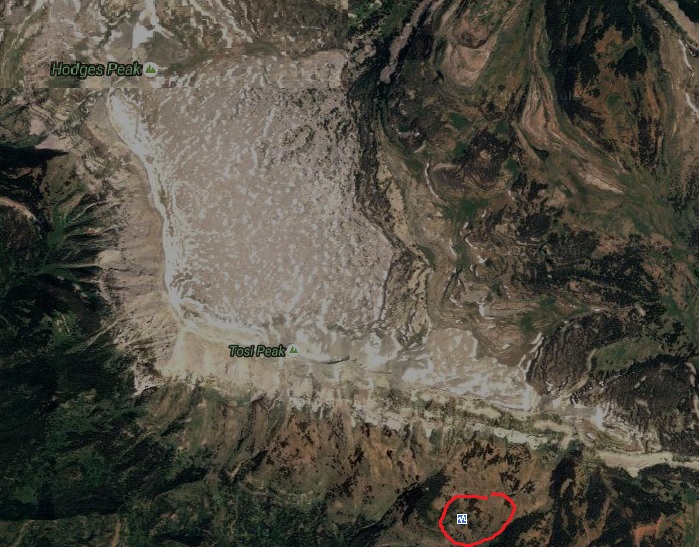
Oh wow, remember how Phoenix358 mentioned that those were 2 different monitoring stations and not 2 different EQ? Well, I took a peak at the station
that recorded the 4.6 and look what I found! Now that is a caldera! An EQ at a caldera! Add all the fires...
Does anyone know where to get the most up to date satellite images?
Does anyone know where to get the most up to date satellite images?
edit on 28-8-2016 by elouina because: (no reason given)
extra DIV new topics
-
Curse of King Tuts Tomb Solved
Ancient & Lost Civilizations: 5 minutes ago -
What allies does Trump have in the world?
ATS Skunk Works: 5 minutes ago -
BIDEN Admin Begins Planning For January 2025 Transition to a New President - Today is 4.26.2024.
2024 Elections: 8 hours ago -
Big Storms
Fragile Earth: 10 hours ago
top topics
-
James O’Keefe: I have evidence that exposes the CIA, and it’s on camera.
Whistle Blowers and Leaked Documents: 15 hours ago, 17 flags -
Australian PM says the quiet part out loud - "free speech is a threat to democratic dicourse"...?!
New World Order: 16 hours ago, 15 flags -
Biden "Happy To Debate Trump"
2024 Elections: 17 hours ago, 14 flags -
Ireland VS Globalists
Social Issues and Civil Unrest: 16 hours ago, 11 flags -
BIDEN Admin Begins Planning For January 2025 Transition to a New President - Today is 4.26.2024.
2024 Elections: 8 hours ago, 9 flags -
Big Storms
Fragile Earth: 10 hours ago, 8 flags -
Shocking Number of Voters are Open to Committing Election Fraud
US Political Madness: 13 hours ago, 7 flags -
RAAF airbase in Roswell, New Mexico is on fire
Aliens and UFOs: 17 hours ago, 5 flags -
Where should Trump hold his next rally
2024 Elections: 13 hours ago, 5 flags -
Gov Kristi Noem Shot and Killed "Less Than Worthless Dog" and a 'Smelly Goat
2024 Elections: 14 hours ago, 5 flags
active topics
-
What allies does Trump have in the world?
ATS Skunk Works • 1 • : RussianTroll -
Curse of King Tuts Tomb Solved
Ancient & Lost Civilizations • 0 • : FlyersFan -
Gaza Terrorists Attack US Humanitarian Pier During Construction
Middle East Issues • 91 • : FlyersFan -
Krystalnacht on today's most elite Universities?
Social Issues and Civil Unrest • 16 • : FlyersFan -
Where should Trump hold his next rally
2024 Elections • 22 • : FlyersFan -
University of Texas Instantly Shuts Down Anti Israel Protests
Education and Media • 324 • : burritocat -
Gov Kristi Noem Shot and Killed "Less Than Worthless Dog" and a 'Smelly Goat
2024 Elections • 68 • : FlyersFan -
"We're All Hamas" Heard at Columbia University Protests
Social Issues and Civil Unrest • 298 • : FlyersFan -
Senator Ron Johnson Interview - PART 1: Mishandling Pandemic To What Ends?
Diseases and Pandemics • 4 • : PrivateAngel -
The Acronym Game .. Pt.3
General Chit Chat • 7757 • : F2d5thCavv2