It looks like you're using an Ad Blocker.
Please white-list or disable AboveTopSecret.com in your ad-blocking tool.
Thank you.
Some features of ATS will be disabled while you continue to use an ad-blocker.

MH370 missing (Part 2)
page: 26share:
originally posted by: roadgravel
Montol said that at 1:28 a.m., Thai military radar "was able to detect a signal, which was not a normal signal, of a plane flying in the direction opposite from the MH370 plane," back toward Kuala Lumpur. The plane later turned right, toward Butterworth, a Malaysian city along the Strait of Malacca.
They say it was headed south and at some later time turned right. How later? Isn't there data? If true the plane was headed south within 7 or 8 minutes of the last radio contact though. I could see that fitting either a plan or an accident.
According to the captain of JAL750 which took off at 1:25am MYT just after 1:30am he had a conversation with the co-pilot of MH370 over Vietnam and he said all seemed normal.
After that MH88 which was further north over Vietnam also had a verbal exchange with MH370 , so if other aircraft over Vietnam were having conversations with MH370 over Vietnam after 1:30am why was there no suggestion by the Captain of JAL750 that MH370 was turning around?
a reply to: earthling42
What does bring us closer to understanding what happened is first figuring out what we can't believe.
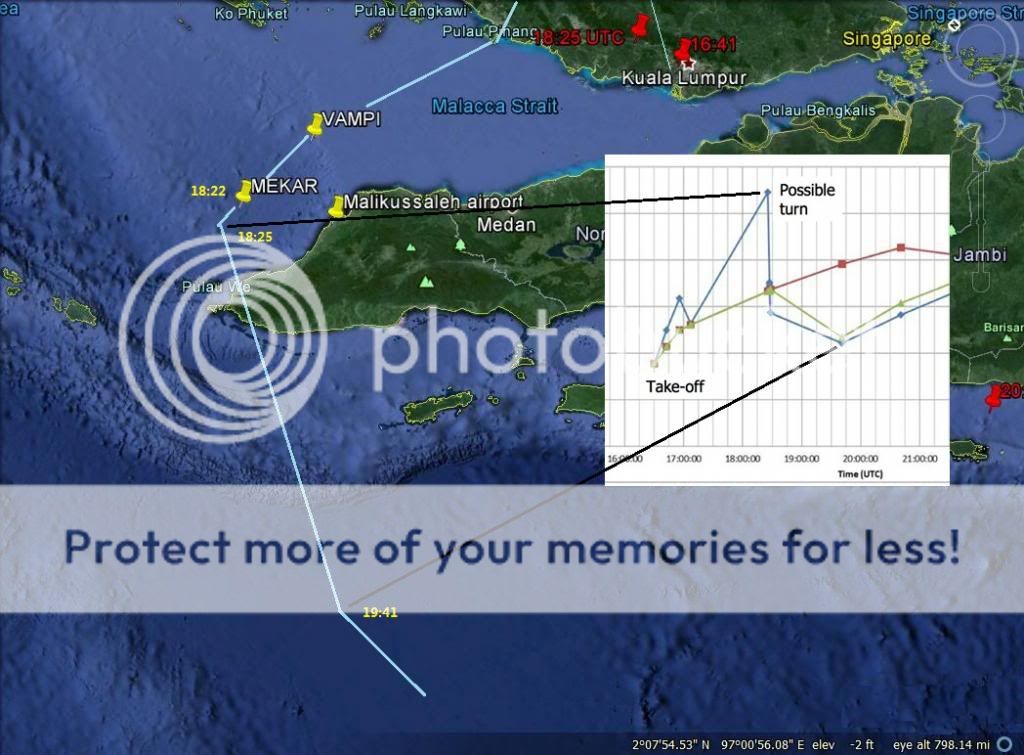
I can't believe the entire alleged flight through the Straits of Malacca. Take a look at this image:
Enlarged image
Why it does not work is that the INMARSAT Burst Offset Frequency chart issued by Malaysia shows a frequency drop between 18:25 UTC and 19:41 UTC, as if MH370 flew away from the satellite.
Yet as you can see from the track plotted by Malaysian investigators they show MH370 flying towards the satellite.
If on the other hand if you support Mike Exner's revised BOF chart (correcting the signal inversion) then it shows MH370 steadily flew east away from Malaysia until at least 18:00+ UTC.
Whichever BOF chart you believe in...neither one supports a flight through the Straits of Malacca.
What does bring us closer to understanding what happened is first figuring out what we can't believe.
I can't believe the entire alleged flight through the Straits of Malacca. Take a look at this image:
Enlarged image
Why it does not work is that the INMARSAT Burst Offset Frequency chart issued by Malaysia shows a frequency drop between 18:25 UTC and 19:41 UTC, as if MH370 flew away from the satellite.
Yet as you can see from the track plotted by Malaysian investigators they show MH370 flying towards the satellite.
If on the other hand if you support Mike Exner's revised BOF chart (correcting the signal inversion) then it shows MH370 steadily flew east away from Malaysia until at least 18:00+ UTC.
Whichever BOF chart you believe in...neither one supports a flight through the Straits of Malacca.
a reply to: sy.gunson
There is even more to see
Just look at that plot and the possible turn, and look again at this picture.

Large image
Instead of a turn there is a strait line to the 18:29 arc which simply can not be according to the BFO.
Tonight i will post more about the radars
There is even more to see
Just look at that plot and the possible turn, and look again at this picture.
Large image
Instead of a turn there is a strait line to the 18:29 arc which simply can not be according to the BFO.
Tonight i will post more about the radars
I needed a good time killer thread today, I found it here and posting to say thanks to the OP and all the posters for a very civil and informative
thread.
Lots of good links and thoughts posted and I was able to understand most of it, sort of :-)
Regards, Iwinder
ETA......I posted this after almost 7 hours of reading and checking out all the links.....LOL I got my time killer.
Lots of good links and thoughts posted and I was able to understand most of it, sort of :-)
Regards, Iwinder
ETA......I posted this after almost 7 hours of reading and checking out all the links.....LOL I got my time killer.
edit on 14-5-2014 by
Iwinder because: (no reason given)
The one thing that stuck in my noggin was the batteries in the cargo bay, I fly a remote helicopter for relaxation and sanity reasons.
My copter uses the Lithium polymer battery or Lipo if you like, the warnings that come with these batteries are numerous and unending on the instructions for them.
I keep them at all times in a "LIPO fire bag" when not in use or when charging.
I just flew the copter for the first time this year on Sunday and when I was charging up the batteries after I dropped one and now I am sleeping with one eye open.
Link below to what I am using.....
en.wikipedia.org...
It seems to be a favourite of NASA......I don't know if that's good or bad?
They go on to warn you that if your copter catches fire when in flight do not approach it and stay up wind from it.
Nasty things these batteries are but they work excellent for me and my copter.
A wanna be pilot's perspective on the battery angle in this thread.
A question to anyone here, are these batteries in the space below the cockpit? I mean are they used for equipment on board for whatever reasons?
Regards, Iwinder
edit on 14-5-2014 by Iwinder because: (no reason given)

originally posted by: earthling42
a reply to: Iwinder
There is a place for cargo in the front and the back of the plane, i do not know in which compartment the batteries were loaded.
Thanks for the reply and the graphic, if they were stored up front I can envision a problem if one of the batteries were faulty.
From my reading on these batteries if one goes and there are more in the same area its going to be a bad bad situation.
Perhaps a Pilot can add to my question as follows?
Are there a lot of rechargeable batteries on a 777 or any newer jet for that matter?
If so I can I assume they are everywhere including under the cockpit?
Food for thought, now back to my Non Pilots chair :-)
Regards, Iwinder
edit on 14-5-2014 by Iwinder because: (no reason given)
Radars in and around Malaisia.
There is no way that an aircraft can fly over the Malacca Strait without being seen.

Large image
Malaysia is also able to track an aircraft near the coast of southern Vietnam.

Large image
The green sections in the first picture is the primary radar coverage, the orange sections is secondary radar coverage.
The radars have a blind spot as seen in the picture below.

Large image
Radars in Thailand

They also cover a great part of the Malacca Strait and far into the Andaman Sea.
Large image
Indonesia is covered with many radars.

The radar in Lhokseumawe which Sy mentioned earlier has a range of 510km.

Large image
The Cocos Islands and Chrismas Island also have radar coverage.

Large image
And finaly Australia with its powerfull Jorn radar.

Large image
No doubt there is also a powerful radar on Diego Garcia too, but i have to see if i can find something about that radar.
But i think it is quite clear that there is simply no way for the aircraft to have evaded the radars.
The last position was LAT 6.97 LON 103.63 heading 040 which means it was flying directly from IGARI towards BIBAN.
How far it had flown towards BIBAN before it made a turn back to Malaysia is a question, we have to consider the radius too, it was flying with a speed of 471kn or more, so the turn radius would have been about 15 mile i think, please correct me if i am wrong.
There is no way that an aircraft can fly over the Malacca Strait without being seen.
Large image
Malaysia is also able to track an aircraft near the coast of southern Vietnam.
Large image
The green sections in the first picture is the primary radar coverage, the orange sections is secondary radar coverage.
The radars have a blind spot as seen in the picture below.
Large image
Radars in Thailand
They also cover a great part of the Malacca Strait and far into the Andaman Sea.
Large image
Indonesia is covered with many radars.
The radar in Lhokseumawe which Sy mentioned earlier has a range of 510km.
Large image
The Cocos Islands and Chrismas Island also have radar coverage.
Large image
And finaly Australia with its powerfull Jorn radar.
Large image
No doubt there is also a powerful radar on Diego Garcia too, but i have to see if i can find something about that radar.
But i think it is quite clear that there is simply no way for the aircraft to have evaded the radars.
The last position was LAT 6.97 LON 103.63 heading 040 which means it was flying directly from IGARI towards BIBAN.
How far it had flown towards BIBAN before it made a turn back to Malaysia is a question, we have to consider the radius too, it was flying with a speed of 471kn or more, so the turn radius would have been about 15 mile i think, please correct me if i am wrong.
edit on 14-5-2014 by
earthling42 because: (no reason given)
a reply to: Iwinder
There is secrecy concerning a part of the cargo, namely the batteries.
Maybe therein lies the answer as to what happened, who knows what it was that they want to keep secret from us.
But yes, Roadgravel posted some links in this thread about the batteries, if there is one thermal runaway, we can expect a chain reaction.
a reply to: earthling42
The reporting skipping the turn to the NE is odd. Reporting always seems to state it turned west at IGARI and never headed toward BITOD.
Something is wrong since day 1. I can't help but be curious as to what it is.
The reporting skipping the turn to the NE is odd. Reporting always seems to state it turned west at IGARI and never headed toward BITOD.
Something is wrong since day 1. I can't help but be curious as to what it is.
a reply to: roadgravel
Yes, that is what they have been saying, it is visible when we look at the replay on FR24 but as you correctly mention, they kept repeating that the aircraft turned at IGARI.
And i agree fully with you, therefore i really hope that people keep searching for answers concerning this unusual disappearance.
There is one thing i would like to mention about the BFO.
A few posts ago i mentioned that the aircraft must have been circling at the time of the three pings, seeing this image on duncans blog leads me to think that he has the same idea.
That would clarify the big spike which drops quikly during those three pings.
In the coming days i am going to be busy with the twisty path of the aircraft, that is what stands out for me as well in the radar plot, and this would likely have been the same when it turned around and for the remaining flight until its final place.
a reply to: earthling42
You have probably looked at this data. I wondered about creating a path in the same fashion if the time / distances were released.
The whole shift idea was direction confirmation, which has worked out well.
I think society is at the point where everyone in business is so worried about money that every thing is a secret, whether is need be or not.
a reply to: roadgravel
If you have Google earth installed on your pc, you can find the KML files here
If you have Google earth installed on your pc, you can find the KML files here
Yesterdays (15 May 2014) update on problem with the underwater search
During the recovery, Bluefin-21 was damaged but was able to be repaired expeditiously with spare parts on board the ADV Ocean Shield.
Examination of the communications problem has established that a hardware defect exists in the transponder mounted on the Ocean Shield and that a defect may also exist in the transponder mounted on the Bluefin-21. This inhibits the ability of the two devices to communicate with each other.
As a consequence, spare parts for both defects will be dispatched from the United Kingdom. The parts are expected to arrive in Western Australia on Sunday.
originally posted by: earthling42
a reply to: Iwinder
There is a place for cargo in the front and the back of the plane, i do not know in which compartment the batteries were loaded.
Lithium batteries were loaded in the aft compartment, sorry i can't recall where I read that but trust me I did read an analysis saying that.
originally posted by: roadgravel
a reply to: earthling42
You have probably looked at this data. I wondered about creating a path in the same fashion if the time / distances were released.
The whole shift idea was direction confirmation, which has worked out well.
I think society is at the point where everyone in business is so worried about money that every thing is a secret, whether is need be or not.
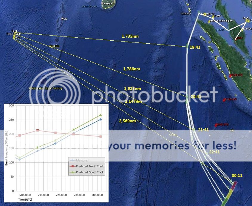
I don't believe it works out at all. The satellite ping chart does not support the tracks which investigators claim MH370 flew:
Enlarged
For example the Burst Offset Chart published 24 March shows a frequency increase after 19:41 UTC analagous to MH370 flying towards the satellite, but the map track shows the opposite.
For the satellite ping chart to be correct the airliner would have to fly a steady heading towards INMARSAT.
a reply to: roadgravel
Another example why the track analysis does not match MH370's satellite ping data:
Enlarged
From 18:25 UTC until 19:41 UTC the Burst Offset Frequency chart shows sharply reducing frequency analogous to MH370 flying away from the satellite.
Malaysia's Government however claims MH370 flew west towards INMARSAT. The satellite handshakes reveal this is a lie
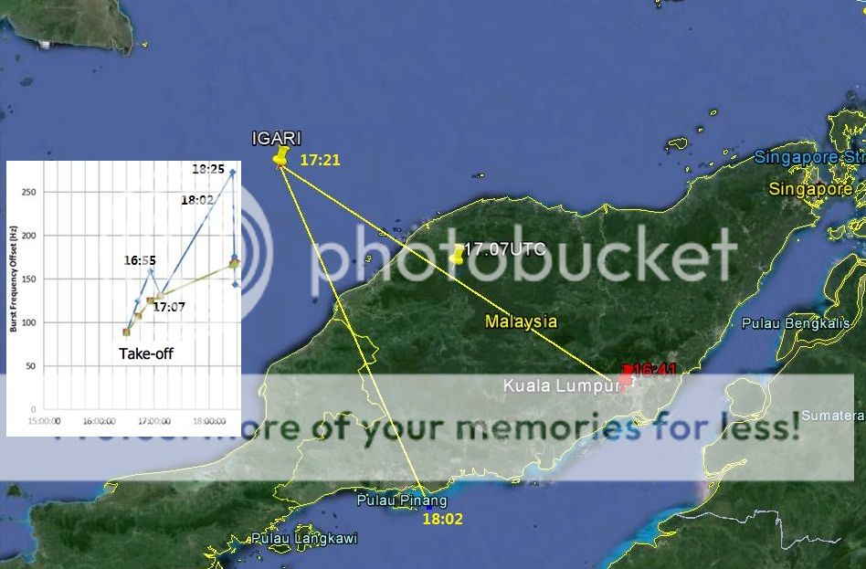
Another example:
Enlarged
The INMARSAT ping chart shows a frequency increase suggesting MH370 flew towards the Straits of Malacca from 17:07 UTC.
Yet we know it was tracked flying east by radar/transponder until 17:27 UTC when it reached BITOD.
Malaysia claims the sharp change in the Burst Offset Frequency chart at 18:25 UTC was a turn, therefore why is there not a similar sharp change in the plot around 17:21 UTC signifying a turn?
Nothing in the satellite ping track matches the directions allegedly flown through the Straits of Malacca.
Another example why the track analysis does not match MH370's satellite ping data:
Enlarged
From 18:25 UTC until 19:41 UTC the Burst Offset Frequency chart shows sharply reducing frequency analogous to MH370 flying away from the satellite.
Malaysia's Government however claims MH370 flew west towards INMARSAT. The satellite handshakes reveal this is a lie
Another example:
Enlarged
The INMARSAT ping chart shows a frequency increase suggesting MH370 flew towards the Straits of Malacca from 17:07 UTC.
Yet we know it was tracked flying east by radar/transponder until 17:27 UTC when it reached BITOD.
Malaysia claims the sharp change in the Burst Offset Frequency chart at 18:25 UTC was a turn, therefore why is there not a similar sharp change in the plot around 17:21 UTC signifying a turn?
Nothing in the satellite ping track matches the directions allegedly flown through the Straits of Malacca.
The guy who did the analysis linked in the previous posts actually didn't have a problem with that part, saying it was a pretty common practice to graph absolute values, implying the original data could be negative as you suggested a long time ago, but he had lots of other problems with Inmarsat's analysis.
originally posted by: sy.gunson
For the satellite ping chart to be correct the airliner would have to fly a steady heading towards INMARSAT.
a reply to: Arbitrageur
Yes, but seeing the graph which Sy made, i do agree with him that the measured offset should increase a lot more to the end.
The main thing is, a northern route cannot be excluded, and the difference in speed during the first part and last part.
Yes, but seeing the graph which Sy made, i do agree with him that the measured offset should increase a lot more to the end.
The main thing is, a northern route cannot be excluded, and the difference in speed during the first part and last part.
new topics
-
BIDEN Admin Begins Planning For January 2025 Transition to a New President - Today is 4.26.2024.
2024 Elections: 3 hours ago -
Big Storms
Fragile Earth: 4 hours ago -
Where should Trump hold his next rally
2024 Elections: 7 hours ago -
Shocking Number of Voters are Open to Committing Election Fraud
US Political Madness: 8 hours ago -
Gov Kristi Noem Shot and Killed "Less Than Worthless Dog" and a 'Smelly Goat
2024 Elections: 8 hours ago -
Falkville Robot-Man
Aliens and UFOs: 9 hours ago -
James O’Keefe: I have evidence that exposes the CIA, and it’s on camera.
Whistle Blowers and Leaked Documents: 9 hours ago -
Australian PM says the quiet part out loud - "free speech is a threat to democratic dicourse"...?!
New World Order: 10 hours ago -
Ireland VS Globalists
Social Issues and Civil Unrest: 11 hours ago -
Biden "Happy To Debate Trump"
2024 Elections: 11 hours ago
top topics
-
James O’Keefe: I have evidence that exposes the CIA, and it’s on camera.
Whistle Blowers and Leaked Documents: 9 hours ago, 17 flags -
Australian PM says the quiet part out loud - "free speech is a threat to democratic dicourse"...?!
New World Order: 10 hours ago, 15 flags -
Blast from the past: ATS Review Podcast, 2006: With All Three Amigos
Member PODcasts: 13 hours ago, 13 flags -
Biden "Happy To Debate Trump"
2024 Elections: 11 hours ago, 13 flags -
Ireland VS Globalists
Social Issues and Civil Unrest: 11 hours ago, 9 flags -
Mike Pinder The Moody Blues R.I.P.
Music: 14 hours ago, 8 flags -
BIDEN Admin Begins Planning For January 2025 Transition to a New President - Today is 4.26.2024.
2024 Elections: 3 hours ago, 7 flags -
What is the white pill?
Philosophy and Metaphysics: 13 hours ago, 6 flags -
Shocking Number of Voters are Open to Committing Election Fraud
US Political Madness: 8 hours ago, 6 flags -
Big Storms
Fragile Earth: 4 hours ago, 6 flags
active topics
-
President BIDEN's FBI Raided Donald Trump's Florida Home for OBAMA-NORTH KOREA Documents.
Political Conspiracies • 40 • : BingoMcGoof -
BIDEN Admin Begins Planning For January 2025 Transition to a New President - Today is 4.26.2024.
2024 Elections • 19 • : Vermilion -
Gov Kristi Noem Shot and Killed "Less Than Worthless Dog" and a 'Smelly Goat
2024 Elections • 60 • : Degradation33 -
Australian PM says the quiet part out loud - "free speech is a threat to democratic dicourse"...?!
New World Order • 7 • : 19Bones79 -
It takes One to Be; Two to Tango; Three to Create.
Philosophy and Metaphysics • 8 • : Compendium -
Big Storms
Fragile Earth • 16 • : rickymouse -
James O’Keefe: I have evidence that exposes the CIA, and it’s on camera.
Whistle Blowers and Leaked Documents • 14 • : 19Bones79 -
RAAF airbase in Roswell, New Mexico is on fire
Aliens and UFOs • 12 • : pianopraze -
A Warning to America: 25 Ways the US is Being Destroyed
New World Order • 29 • : 19Bones79 -
What is the white pill?
Philosophy and Metaphysics • 22 • : AlexandrosOMegas