It looks like you're using an Ad Blocker.
Please white-list or disable AboveTopSecret.com in your ad-blocking tool.
Thank you.
Some features of ATS will be disabled while you continue to use an ad-blocker.

Want to Photo something new and different? Roads Less Travelled? Check out this map.
page: 18
share:
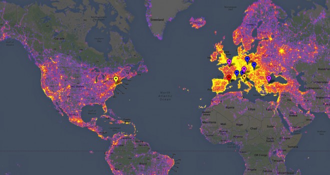
Google has recently put out what it calls a "Heat Map" detailing the world's most photographed places.
Want something original, new, and not so photographed?
Aim for the places showing grey!
Source Article - Wired
Google Heat Map (Interactive - World's Most Photographed Places)
Perhaps this might help in choosing an upcoming vacation?
Roads less travelled and all?
Want something original, new, and not so photographed?
Aim for the places showing grey!
Source Article - Wired
Tourists rejoice. A new Google-generated “heat map” showing the most photographed locations on Earth means you’ll know exactly how to get to the most vacation slideshow-worthy spots on the globe.
The map accounts for the top 15,000 most photographed locations in Google’s Panorimo service, where users can submit geotagged photographs for inclusion in Google Earth. New York tops the list, but even a cursory glance shows that Europe is absolutely ablaze with shutter clicks. Locations are viewable down to street level, and are ranked based on the number of shots within a few square miles of the center of a given location.
Each location is linked to the original images, Google’s Street View, its Wikipedia entry and other online resources like a route planner, meaning you’ll never need another tour bus to show you all the photographic hot spots. If, on the other hand, you can’t stand tourists, this map will be useful for showing you where you should avoid.
Google Heat Map (Interactive - World's Most Photographed Places)
Perhaps this might help in choosing an upcoming vacation?
Roads less travelled and all?
reply to post by AliceBleachWhite
Yea! This is inspiring! I would like to travel all the grey and make a travel guide, now that would be a fun way to spend a year! A travel guide to earths least explored places, haha, might get to the grey bits and find out they are grey for a reason, or we could stumble on a pyramid!!! Who knows!!??
That grey hill over there looks awefully suspicious!!!! Don't you think!?
I bet the grey places are pretty lame, theres a reason people dont take photos there. Its either boring, or dangerous, check africa and the amazon
rainforest
reply to post by AliceBleachWhite
This map would also be useful for people looking to bug out in a survival situation (or camping. LOL). Notice that most of the mountain ranges of the US have been heavily photographed. Lots of photographs equals lots of people with easy access to those areas.
This map would also be useful for people looking to bug out in a survival situation (or camping. LOL). Notice that most of the mountain ranges of the US have been heavily photographed. Lots of photographs equals lots of people with easy access to those areas.
new topics
-
Oklahoma mandates Bibles in public classrooms
Other Current Events: 9 hours ago
top topics
-
Oklahoma mandates Bibles in public classrooms
Other Current Events: 9 hours ago, 8 flags -
Russian ambasador leaves the US
World War Three: 13 hours ago, 6 flags -
Is she trying to be The Joker ?
General Chit Chat: 14 hours ago, 5 flags -
Free Stays
Short Stories: 15 hours ago, 3 flags -
Peter Santenello on YouTube.
Television: 12 hours ago, 2 flags
8