It looks like you're using an Ad Blocker.
Please white-list or disable AboveTopSecret.com in your ad-blocking tool.
Thank you.
Some features of ATS will be disabled while you continue to use an ad-blocker.

Is that a cyclone over Canada?
page: 14
share:
During the night the wind was howling (still is, as a matter of fact), and we even had heavy hail.
So this morning I decided to check Canada's satellite images, and this is what I found:
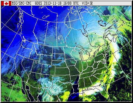
This system is slowly rotating on itself near the Hudson bay. I'm not very good with storms classification.
Is that a cyclone?
Thanks,
Swan.
So this morning I decided to check Canada's satellite images, and this is what I found:
This system is slowly rotating on itself near the Hudson bay. I'm not very good with storms classification.
Is that a cyclone?
Thanks,
Swan.
edit on 18-11-2013 by swanne because: (no reason given)
Its the "day after tomorrow"...........
today!
A snow-clone?
Ici-clone?
today!
A snow-clone?
Ici-clone?
reply to post by dashen
No, it didn't bring snow, just rain and hail.
Hm, BTW I'm not sure if I should call it a cyclone or a hurricane. If my memory is correct, these terms are synonymous, right???
No, it didn't bring snow, just rain and hail.
Hm, BTW I'm not sure if I should call it a cyclone or a hurricane. If my memory is correct, these terms are synonymous, right???
reply to post by swanne
It could be a supercell. Strong thunderstorms like that tend to have rotation in them, which is part of how they spin off a tornado.
It could be a supercell. Strong thunderstorms like that tend to have rotation in them, which is part of how they spin off a tornado.
edit on
11/18/2013 by Zaphod58 because: (no reason given)
reply to post by swanne
Cyclones (called hurricanes in the western hemisphere) are tropical low pressure centers.
While it is a deep low, it is not tropical nor are its winds high enough to reach hurricane categories.
Cyclones (called hurricanes in the western hemisphere) are tropical low pressure centers.
While it is a deep low, it is not tropical nor are its winds high enough to reach hurricane categories.

edit on 11/18/2013 by Phage because: (no reason given)
Zaphod58
reply to post by swanne
It could be a supercell. Strong thunderstorms like that tend to have rotation in them, which is part of how they spin off a tornado.
You're probably right (thanks!). And hurricanes usually have an eye, which the storm in the pic does not have.
reply to post by swanne
OP, this map is strictly United States, but a lot can be seen by the currents running across and around the border from the Pacific to the Atlantic that way. For instance, at the moment, there are two very very different current patterns between the Northern Plains and everything to the East. The Plains are blowing hard, due north...while the current east is running almost true east with the hint of a curve up and around at Maine.
Could be?
National Wind Map
* Note: That is probably as close to a real time display as one will find (or PLEASE share a better one..lol). So the currents change on that regularly. It's what makes it valuable, IMO.
edit on 18-11-2013 by Wrabbit2000 because: (no reason given)
reply to post by Phage
Okay, so it's just a storm. Whew, thanks for the info!
"Cyclones" are tropical. I'll remember that.
Okay, so it's just a storm. Whew, thanks for the info!
"Cyclones" are tropical. I'll remember that.
reply to post by swanne
I noticed this cyclonic shape yesterday as well... Truth be told this occurrence happens regularly. I have seen two or three instances since this summer alone.
I noticed this cyclonic shape yesterday as well... Truth be told this occurrence happens regularly. I have seen two or three instances since this summer alone.
dashen
Its the "day after tomorrow"...........
today!
A snow-clone?
Ici-clone?
Lol. No snow... Just a tone of rain and thunderstorms. And 90km winds. Brutal.
reply to post by Wrabbit2000
Both, by the way, are the result of the high pressure area centered over Kansas. Winds rotate clockwise around highs and counterclockwise around lows (in the northern hemisphere).
You have your wind directions mixed up. Wind directions are given in the direction from which the wind blows. The plains are showing southerly winds and the midwest is showing westerlies.
The Plains are blowing hard, due north...while the current east is running almost true east with the hint of a curve up and around at Maine.
Both, by the way, are the result of the high pressure area centered over Kansas. Winds rotate clockwise around highs and counterclockwise around lows (in the northern hemisphere).
reply to post by Phage
Thanks for the added context. In fact, the center seems about over Coffeyville, Kansas as of a few moments ago. My wife and I were looking at the map overlayed with borders on a big screen. It's fascinating how quickly and completely the wind patterns can change across a continent, as that is currently similar but also very different from how it looked just a few hours ago.
Thanks for the added context. In fact, the center seems about over Coffeyville, Kansas as of a few moments ago. My wife and I were looking at the map overlayed with borders on a big screen. It's fascinating how quickly and completely the wind patterns can change across a continent, as that is currently similar but also very different from how it looked just a few hours ago.
Phage
reply to post by swanne
Cyclones (called hurricanes in the western hemisphere) are tropical low pressure centers.
While it is a deep low, it is not tropical nor are its winds high enough to reach hurricane categories.
edit on 11/18/2013 by Phage because: (no reason given)
Center in the lower Hudson Bay!?
That's damn weird. I don't think I ever saw that.
But then again the poles are still moving, so it's not that surprising there's bogus events like these.
my understanding is this was the storm system that was causing tornado's in the US and it did move in to Canada last night, Power was out for me from
about 10pm until about 6 this morning.
The was no snow where I am, Toronto area, but I heard there was heavy snow more north around Georgian Bay.
The was no snow where I am, Toronto area, but I heard there was heavy snow more north around Georgian Bay.
reply to post by Kr0nZ
Im in Toronto/Markham, we had power, but Stouffville, 20km north, was out of power.
Im in Toronto/Markham, we had power, but Stouffville, 20km north, was out of power.
Yes, it's a cyclone. Otherwise known as a depression or low pressure system.
A tropical cyclone (which would be called a hurricane if it formed in the Atlantic or East Pacific - typhoon is used in the NW Pacific and in the SW Pacific and Indian Ocean they are simply called cyclones) is a specific type of depression or low pressure system, and by definition cannot form at mid or high latitude.
Many depressions in the North Atlantic can produce winds of hurricane strength (sustained speeds of over 74mph) though.
Here at DeBeers Diamond Mine lost power this morning
We are running on 6 1.2 Mw generator most off the west coast of
James Bay has been with no power and may not be back up till sometime late tomorrow.
Blizzard white-out condition all day with 50 to 70 mile wind
After a few hours we lost one generator down till part can be flown in.
Sure hope it get better tomorrow my two week off start tomorrow weather permitting
DeBeers Victor Diamond Mine
edit on 18-11-2013 by Trillium because: (no reason
given)
Zaphod58
reply to post by swanne
It could be a supercell. Strong thunderstorms like that tend to have rotation in them, which is part of how they spin off a tornado.edit on 11/18/2013 by Zaphod58 because: (no reason given)
No it couldn't. While supercells have rotation, their scale is a lot smaller; ~2 to 10 kilometers and are actually called mesocyclones. You really couldn't tell for sure any rotating supercell from a single satellite picture featuring a whole continent. In the OP's satellite picture you have a synoptic scale event of a low pressure in quite early stages of it's life cycle.
new topics
-
This is adorable you guys!
General Chit Chat: 7 hours ago -
Reprehensible Behavior
US Political Madness: 7 hours ago -
Defending the need for adherence to Old Testament commandments under the new covenant of Christ
Conspiracies in Religions: 8 hours ago
top topics
-
Reprehensible Behavior
US Political Madness: 7 hours ago, 10 flags -
Those Drones over NJ and elsewhere
Aliens and UFOs: 13 hours ago, 8 flags -
South Korean coup was an attempt to start WW3
World War Three: 13 hours ago, 7 flags -
This is adorable you guys!
General Chit Chat: 7 hours ago, 7 flags -
Archer aviation and the NJ drones
Aircraft Projects: 13 hours ago, 5 flags -
Defending the need for adherence to Old Testament commandments under the new covenant of Christ
Conspiracies in Religions: 8 hours ago, 5 flags
active topics
-
Defending the need for adherence to Old Testament commandments under the new covenant of Christ
Conspiracies in Religions • 12 • : randomuser2034 -
The Mystery Drones and Government Lies --- Master Thread
Political Conspiracies • 104 • : DaydreamerX -
Drones everywhere in New Jersey ---and Elsewhere Master Thread
Aliens and UFOs • 171 • : nugget1 -
Post A Funny (T&C Friendly) Pic Part IV: The LOL awakens!
General Chit Chat • 7912 • : imitator -
This is adorable you guys!
General Chit Chat • 4 • : CriticalStinker -
The Acronym Game .. Pt.4
General Chit Chat • 1016 • : FullHeathen -
Could rampant land speculation have caused the Civil War?
History • 35 • : matafuchs -
George Stephanopoulos and ABC agree to pay $15 million to settle Trump defamation suit
Mainstream News • 23 • : Brotherman -
Pelosi injured in Luxembourg
Other Current Events • 45 • : rickymouse -
Nov 2024 - Former President Barack Hussein Obama Has Lost His Aura.
US Political Madness • 19 • : Connector
4