It looks like you're using an Ad Blocker.
Please white-list or disable AboveTopSecret.com in your ad-blocking tool.
Thank you.
Some features of ATS will be disabled while you continue to use an ad-blocker.

Earth's Green Places Mapped in High Resolution. Pictures.
page: 112
share:
Being from Ireland I naturally have a penchant for green, so I liked this and thought I would share
Recently released images from the NASA/SOAA Suomi mpp satellite show our entire planets vegetation.
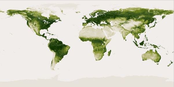
Each weekly vegetation image is around 13 GB in size, 80,000 x 40,000 pixels. If you were to print the image it would require a piece of paper 93 feet wide by 46.5 feet tall.
Here is a short video using the same data from SOAA/NASA showing vegetation changes over the space of a year. I love how my little Emerald Isle tends to stay green whatever the season.
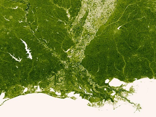
The Mississippi River
Taken at the end of March this year
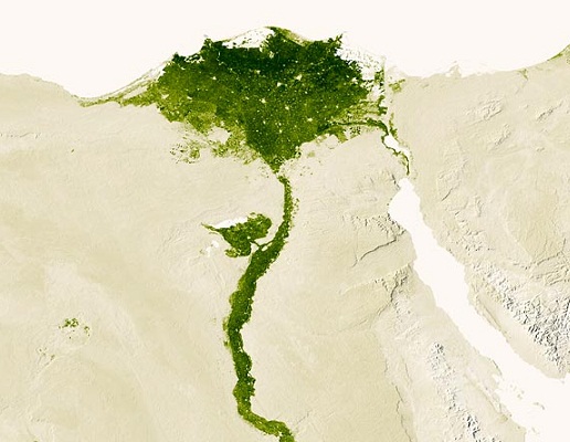
The Nile River
Taken in July 2012
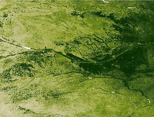
U.S. Midwest state of Nebraska
Taken in July 2012
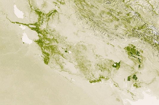
Iraq. The Tigris and Euphrates Rivers
Taken in November 2012
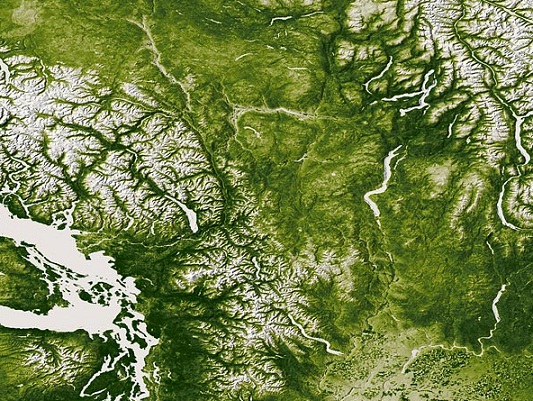
The Rocky, Cascade, and Coast mountain ranges of the Pacific Northwest
Taken in June2012
Here are a couple of links with more information on the images -
NOAA
National Geographic
Recently released images from the NASA/SOAA Suomi mpp satellite show our entire planets vegetation.
Each weekly vegetation image is around 13 GB in size, 80,000 x 40,000 pixels. If you were to print the image it would require a piece of paper 93 feet wide by 46.5 feet tall.
The images—taken between April 2012 and 2013—show the darkest green areas as the lushest, while the pale colors signify sparse vegetation cover due to snow, drought, rock, or urban areas, according to the U.S. National Oceanographic and Atmospheric Administration. Mapping vegetation has some practical uses, including forecasting weather or understanding how to best use agricultural land.
Here is a short video using the same data from SOAA/NASA showing vegetation changes over the space of a year. I love how my little Emerald Isle tends to stay green whatever the season.
The Mississippi River
Taken at the end of March this year
The Nile River
Taken in July 2012
U.S. Midwest state of Nebraska
Taken in July 2012
Iraq. The Tigris and Euphrates Rivers
Taken in November 2012
The Rocky, Cascade, and Coast mountain ranges of the Pacific Northwest
Taken in June2012
Here are a couple of links with more information on the images -
NOAA
National Geographic
That's amazing, thanks for posting.
I really like the picture of the Nile river, it looks like a giant tree!
I really like the picture of the Nile river, it looks like a giant tree!
Looks like most of the planet is covered in vegetation, whats all this worry about humans destroying the place then?
Really cool though!
Really cool though!
edit on 20-6-2013 by roughycannon because: (no reason given)
reply to post by Lady_Tuatha
Nice visualization of how green the planet really is.
I am surprised at Africa though. I had thought it was covered with allot more desert than that.
Thank for posting.
Nice visualization of how green the planet really is.
I am surprised at Africa though. I had thought it was covered with allot more desert than that.
Thank for posting.
Originally posted by roughycannon
Looks like most of the planet is covered in vegetation, whats all this worry about humans destroying the place then?
Really cool though!edit on 20-6-2013 by roughycannon because: (no reason given)
The Nasa images don't fully show the full extend of our destruction, look at the BP spill for example. We will destroy this planet one way or another.
On a less depressing note, great pics and I erge you guys to also bring in some nature into your homes. Aquascaping is a great start.
reply to post by Lady_Tuatha
I feel bad for saudi arabians they have no green
your from ireland thats awesome
I feel bad for saudi arabians they have no green
your from ireland thats awesome
reply to post by TritonTaranis
Yeah South Africa has far lusher land than North Africa, that's probably why foreigners set up colonies there, well that and the diamond and gold mines.
Yeah South Africa has far lusher land than North Africa, that's probably why foreigners set up colonies there, well that and the diamond and gold mines.
Nice I can see my house in the last picture. Jk.
But it's true, it's really green here unlike a lot of places i've seen.
But it's true, it's really green here unlike a lot of places i've seen.
Thanks for posting this! I have an affinity for green as well as I'm Irish, too (hence my user name lol).
It's intriguing to me that there seems to be a band of no vegetation stretching from northern Africa all the way to the interior of China. The "band of desert" does not continue to North America, though. It's weird because, theoretically, if it were climate linked, the same would appear in North America at the corresponding latitudes.
In any case, interesting product of technological innovation! Thanks OP!
reply to post by litlirishone
Us Irish and our green where abouts in Ireland are you? Im up north :-)
Us Irish and our green where abouts in Ireland are you? Im up north :-)
reply to post by Lady_Tuatha
There's almost a hint of green near me...
Australia, though... Sheesh! You'd think they could dig a couple of trenches/rivers from northwest to south and southeast...and make more of the land habitable. One good dust storm and 2/3 of the top soil (is there any?) is gone.
(BTW - Would love to go to Ireland. Is the IRA conflict still a matter of concern?)
reply to post by WanDash
Yeah Australia gets far too hot, I would die over there lol. It looks so arid on that map.
nah 'The troubles' isnt as big an issue over here now as they used to be. Just a very small minority of bitter people on both sides that try to keep it going ( a few small breakaway groups ), they are a dwindling bunch tho, the majority of people nowadays just want to get along and move away from the fighting. So yeah it is a lot more peaceful here now, more and more tourists are visiting each year also
new topics
-
Leading Surgeon from Al-Shifa Hospital Dies in Israeli Custody
Middle East Issues: 1 hours ago -
Zionists of ATS assemble
Political Issues: 5 hours ago -
For Votes - President BIDEN Opens ObamaCare Health Ins to Illegal Aliens Eff Nov 1st 2024.
2024 Elections: 10 hours ago -
EPA sues San Francisco for dumping billions of gallons of sewage into Pacific Ocean
US Political Madness: 10 hours ago
top topics
-
Wounded Orangutan seen using a Plant as Medicine for the First Time
Fragile Earth: 15 hours ago, 17 flags -
Study Finds The More Covid Vaccine Doses You Have, the More Likely You Are to Get Covid
Medical Issues & Conspiracies: 15 hours ago, 14 flags -
Farmers jailed without due process
General Conspiracies: 17 hours ago, 10 flags -
EPA sues San Francisco for dumping billions of gallons of sewage into Pacific Ocean
US Political Madness: 10 hours ago, 9 flags -
For Votes - President BIDEN Opens ObamaCare Health Ins to Illegal Aliens Eff Nov 1st 2024.
2024 Elections: 10 hours ago, 8 flags -
UN Estimates Rebuilding Gaza Will Cost Up To 40 Billion Dollars
Middle East Issues: 14 hours ago, 8 flags -
Democratic Rep. Henry Cuellar and wife indicted on federal bribery charges
US Political Madness: 16 hours ago, 6 flags -
SEC shuts down Trump Media auditor, BF Borgers, over fraud
Mainstream News: 16 hours ago, 5 flags -
Zionists of ATS assemble
Political Issues: 5 hours ago, 5 flags -
An AI-controlled fighter jet took the Air Force leader for a historic ride
Military Projects: 16 hours ago, 4 flags
active topics
-
Study Finds The More Covid Vaccine Doses You Have, the More Likely You Are to Get Covid
Medical Issues & Conspiracies • 24 • : Dalamax -
Doctors Predict Epidemic of Prion Brain Diseases From mRna Jab
Health & Wellness • 65 • : chr0naut -
Leading Surgeon from Al-Shifa Hospital Dies in Israeli Custody
Middle East Issues • 3 • : 19Bones79 -
Wounded Orangutan seen using a Plant as Medicine for the First Time
Fragile Earth • 26 • : Kurokage -
UN Estimates Rebuilding Gaza Will Cost Up To 40 Billion Dollars
Middle East Issues • 48 • : Plugit -
Poll - Catholic Support Swings to Trump By Significant Margin
2024 Elections • 30 • : Disgusted123 -
For Votes - President BIDEN Opens ObamaCare Health Ins to Illegal Aliens Eff Nov 1st 2024.
2024 Elections • 16 • : Disgusted123 -
The Acronym Game .. Pt.3
General Chit Chat • 7789 • : bally001 -
Zionists of ATS assemble
Political Issues • 9 • : cherokeetroy -
-@TH3WH17ERABB17- -Q- ---TIME TO SHOW THE WORLD--- -Part- --44--
Dissecting Disinformation • 790 • : daskakik
12