It looks like you're using an Ad Blocker.
Please white-list or disable AboveTopSecret.com in your ad-blocking tool.
Thank you.
Some features of ATS will be disabled while you continue to use an ad-blocker.

Quake Watch 2013
page: 53share:
reply to post by ericblair4891
There is a way to prove it, but IRIS is down and I cannot get any seismograms and/or data files.
Once it is back i will take a look.
There is a way to prove it, but IRIS is down and I cannot get any seismograms and/or data files.
Once it is back i will take a look.
reply to post by muzzy
THANKS MUCH for the China info. A lot of my heart is still with the Chinese people and culture.
The buildings--particularly in rural areas are not very quake resistant at all.
Adobe construction is common even in the cities in many areas.
And, even in Taiwan, some of the . . . qualities . . . of construction depended on what folks could get away with in terms of cutting corners.
Thankfully, in China . . . construction folks, contractors, engineers . . . can suffer great punishment--up to and including death--for neglect and corruption resulting in many quake deaths.
Though I wonder how many are actually deterred from such activities by such punishments. Sigh.
Interesting times we live in . . . for sure.
Thanks for all you do on such scores.
reply to post by PuterMan
I enjoy your reports, Puterman, especially the average days between events data. Thanks.
This Alaska quake was very shallow (unless it gets revised ), only 400 meters.
source
I enjoy your reports, Puterman, especially the average days between events data. Thanks.
This Alaska quake was very shallow (unless it gets revised ), only 400 meters.
5.1 69km SE of Old Iliamna, Alaska 2013-03-10 17:11:05 59.278°N 154.124°W 0.4
5.5 135km SW of Kokopo, Papua New Guinea 2013-03-10 16:49:20 5.308°S 151.501°E 56.5
source
edit on 3/10/2013 by Olivine because: (no reason given)
reply to post by BO XIAN
Thanks,
wait until I get to doing the historic data back to 1831BC, Taiwan is obliterated with icons, you can't see any towns or features on the map unless you zoom into almost ground level, its a wonder anyone survived!
Thanks,
wait until I get to doing the historic data back to 1831BC, Taiwan is obliterated with icons, you can't see any towns or features on the map unless you zoom into almost ground level, its a wonder anyone survived!
Originally posted by azureskys
Sunday March 10 2013,
10:18:17 UTC
15 minutes ago off the coast of Guatemala
5.8
17.1 USGS Feed
Has been quiet there this month
link to INTER list (covers the whole Central America region), usually you have to scroll down the page to see them all!
USGS/SLU Regional Moment Solution, 'hidden' but propagated to EMSC-CSEM tensor page.
Not attached to Event ID ak10670551 page at 19:53 GMT/UTC, one must manually look for it on USGS.
earthquake.usgs.gov/earthquakes/eqarchives/fm/neic_b000fica_rmt.php
Not attached to Event ID ak10670551 page at 19:53 GMT/UTC, one must manually look for it on USGS.
earthquake.usgs.gov/earthquakes/eqarchives/fm/neic_b000fica_rmt.php
edit on 10-3-2013 by wujotvowujotvowujotvo because: (no reason
given)
Magnitude 5.7Mw (5.5mb on phase data)
Sunday, March 10, 2013 at 16:49:19 UTC
Monday, March 11, 2013 at 02:49:19 AM at epicenter
Location 5.304°S, 151.512°E
Depth 60 km (37.3 miles) set by location program
Region NEW BRITAIN REGION, PAPUA NEW GUINEA
Distances 135 km (83 miles) SW of Kokopo, Papua New Guinea
152 km (94 miles) E of Kimbe, Papua New Guinea
source
GFZ doesn't have mag type, must be mb
F-E Region: New Britain Region, P.N.G.
Time: 2013-03-10 16:49:15.5 UTC
Magnitude: 5.4
Epicenter: 151.58°E 5.26°S
Depth: 10 km
Status: A - automatic
geofon.gfz-potsdam.de...
shows good on LISS SNZO, 1700 line
Sunday March 10 2013, 17:11:06 UTC 4 hours ago Southern Alaska 5.1 12.0 USGS Feed
Sunday March 10 2013, 21:17:13 UTC 13 minutes ago Southern Alaska 4.5 110.5 USGS
Sunday March 10 2013, 21:17:13 UTC 13 minutes ago Southern Alaska 4.3 117.0 USGS
Sunday March 10 2013, 21:05:19 UTC 24 minutes ago Southern Alaska 4.2 56.0 USGS
Sunday March 10 2013, 21:05:18 UTC 24 minutes ago Southern Alaska 4.2 61.2 USGS
quakes.globalincidentmap.com...quakes.globalincidentmap.com...
Alaska is really rumbling right now!
edit on 10-3-2013 by azureskys because: add on
edit on 10-3-2013 by azureskys because:
added more
EMSC
Raise to match USGS. How surprising NOT!
Potsdam have it as6.4 6.6 (Manually revised)
USGS have 6.7!!!!
Location in Google Maps
Derived from Event Data Source: USGS
Powered by QVSData
USGS body wave moment tensor now in. Mag 6.5 Mw
USGS wphase moment temsor now in Mag 6.5 Mw
So the question is will it be reduced tomorrow, or on the 18th March. I go for the 18th. Wow, downgraded already!!!. My apologies USGS.
Magnitude M6.26.7
Region NEW BRITAIN REGION, P.N.G.
Date time 2013-03-10 22:51:50.5 UTC
Location 6.80 S ; 148.36 E
Depth 10 km
Distances 2349 km NW Brisbane (pop 1,843,392 ; local time 08:51:50.5 2013-03-11)
325 km NE Port moresby (pop 283,733 ; local time 08:51:50.5 2013-03-11)
152 km E Lae (pop 76,255 ; local time 08:51:50.5 2013-03-11)
61 km SE Finschhafen (pop 1,054 ; local time 08:51:50.5 2013-03-11)
Raise to match USGS. How surprising NOT!
Potsdam have it as
USGS have 6.7!!!!
Magnitude 6.7 - New Britain Region. Papua New Guinea
Location in Google Maps
- Date-Time: Sunday, March 10, 2013 @ 22:51:54 UTC
- Earthquake location: 6.986°S, 148.311°E,
- Earthquake depth: 19.5 km
- Distances:
64km (39mi) SE of Finschhafen, Papua New Guinea
148km (91mi) ESE of Lae, Papua New Guinea
178km (110mi) ENE of Wau, Papua New Guinea
183km (113mi) E of Bulolo, Papua New Guinea
297km (184mi) NNE of Port Moresby, Papua New Guinea
- Event ID: pt13069000
Derived from Event Data Source: USGS
Powered by QVSData
USGS body wave moment tensor now in. Mag 6.5 Mw
USGS wphase moment temsor now in Mag 6.5 Mw
So the question is will it be reduced tomorrow, or on the 18th March. I go for the 18th. Wow, downgraded already!!!. My apologies USGS.
edit on 10/3/2013 by PuterMan because: (no reason given)
update to post by wujotvowujotvowujotvo
earthquake.usgs.gov/earthquakes/eqarchives/fm/ak10670551_rmt.php
earthquake.usgs.gov/earthquakes/eventpage/ak10670551#technical_moment-tensor
Only tensor for 21:17 UTC event
earthquake.usgs.gov/earthquakes/eqarchives/fm/ak10670646_rmt.php
earthquake.usgs.gov/earthquakes/eventpage/ak10670646#technical_moment-tensor
reply to post by PuterMan
I doubt that 10km will be the true depth but even 40km seems very shallow for this region?
Tsunami alerts?
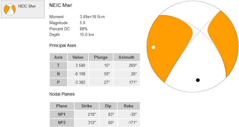
Magnitude M 6.2 6.7 Region NEW BRITAIN REGION, P.N.G. Date time 2013-03-10 22:51:50.5 UTC Location 6.80 S ; 148.36 E Depth 10 km Distances 2349 km NW Brisbane (pop 1,843,392 ; local time 08:51:50.5 2013-03-11) 325 km NE Port moresby (pop 283,733 ; local time 08:51:50.5 2013-03-11) 152 km E Lae (pop 76,255 ; local time 08:51:50.5 2013-03-11) 61 km SE Finschhafen (pop 1,054 ; local time 08:51:50.5 2013-03-11)
I doubt that 10km will be the true depth but even 40km seems very shallow for this region?
Tsunami alerts?
edit on 10-3-2013 by SpaceJockey1 because: add quote
somehow the whole region between papua newguinea and vanuatu seems really unstable the last months, I wonder what is going on there
Whilst IRD can be a bit wild in their magnitudes they do have one which I found on the seismograms which is NOT mentioned by any of the main
agencies:
IRD Earthquake Details
Date Magn. Localisation
09/03/2013 13:37:04 4.8 Vanuatu Islands
I don't think they are wrong on this one, in fact they may be light.
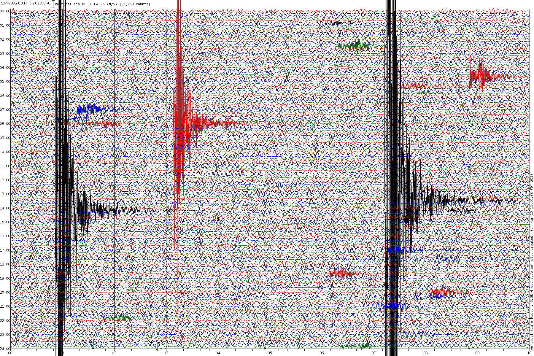
The trouble is that other ones they say are Vanuatu I cannot see on the seismogram for SANVU, for example
IRD Earthquake Details
Date Magn. Localisation
09/03/2013 10:46:25 3.9 Vanuatu Islands
The same day but is not visible
My point is that a quake that was almost certainly a 4.5 min and probably a 4.8, was not picked up by anyone else.
IRD Earthquake Details
Date Magn. Localisation
09/03/2013 13:37:04 4.8 Vanuatu Islands
I don't think they are wrong on this one, in fact they may be light.

The trouble is that other ones they say are Vanuatu I cannot see on the seismogram for SANVU, for example
IRD Earthquake Details
Date Magn. Localisation
09/03/2013 10:46:25 3.9 Vanuatu Islands
The same day but is not visible
My point is that a quake that was almost certainly a 4.5 min and probably a 4.8, was not picked up by anyone else.
reply to post by SpaceJockey1
EMSC have now dropped back to 6.6 @ 60km deep. GFZ Potsdam have 6.6 @ 53 km, USGS have 6.7 Mwp @ 84.3 km.
And they changed it again
EMSC have now dropped back to 6.6 @ 60km deep. GFZ Potsdam have 6.6 @ 53 km, USGS have 6.7 Mwp @ 84.3 km.
And they changed it again
Parameter Value Uncertainty
Magnitude 6.7 Mwp Not Specified
Location 6.653°S, 148.155°E ± 13.6 km
Depth 28.9 km ± 5.9 km
Number of Stations Used 100
Number of Phases Used 103
Minimum Distance 517.6 km (4.65°)
Travel Time Residual 1.30 sec
Azimuthal Gap 19°
Review Status REVIEWED
Event ID usb000fij4
edit on 10/3/2013 by PuterMan because: (no reason given)
Is this maybe a swarm ???
Monday March 11 2013, 00:05:47 UTC 8 hours ago New Britain region, Papua New Guinea 4.9
Monday March 11 2013, 01:43:27 UTC 6 hours ago New Britain region, Papua New Guinea 5.2
Monday March 11 2013, 01:48:10 UTC 6 hours ago New Britain region, Papua New Guinea 4.7
Monday March 11 2013, 01:56:13 UTC 6 hours ago New Britain region, Papua New Guinea 4.7
Monday March 11 2013, 02:20:15 UTC 6 hours ago New Britain region, Papua New Guinea 4.7
Monday March 11 2013, 02:15:49 UTC 6 hours ago New Britain region, Papua New Guinea 4.9
Monday March 11 2013, 02:30:47 UTC 6 hours ago New Britain region, Papua New Guinea 4.7
Monday March 11 2013, 06:21:04 UTC 2 hours ago eastern New Guinea region, Papua New Guinea 4.6
Monday March 11 2013, 08:22:14 UTC 19 minutes ago New Britain region, Papua New Guinea 4.8
I remember the Santa Cruz Islands zone doing the same just before a very large quake.
edit on 7/30/2012 by dreamfox1 because: quakes.globalincidentmap.com...
WARNING: The following post contains many f-words. Like a drunken sailor, or like a drill sargent, I want to say the f-word every other frackin'
word. f f f f f f f f f - those f'in frackers.
Why am I so incensed?
Why?
Because of language. The f'in language. I can't the the f'in' f-word, but lawmakers and big f'in' wigs government and business can say things even more profane than the f'in' f-word. They can say f'in' lies with no one holding them to account. I say the f'in f-word here, and I'm censored. Yet, the f'n f-words that are coming out of my mouth do little to no harm, but, the f'n lies they tell are harming people. Tell me that makes any f'in' sense. Rhetorical- no need to explain.
Here's a statement we must examine though.
“It really hasn’t been earthquakes, it’s been seismic activity,” he said.
King said he was skeptical of the link between the drilling and the shaking underground, but “the good news is nobody’s felt it, there hasn’t been any damage we have some time to kind of look at it.”
Texas State Representative, REPUBLICAN, Phil King
You are a moron sir. An earthquake is seismic activity. Let's make up new f'in' definitions for real things. Let's use what George Orwell called doublespeak. The Right Dishonourable lawmaker from the Lone Star State is demonstrating this manipulation in its pure form. He is using scientfic language, and distorting it so it sounds harmless. I can't go on anymore. Read the f'in' article for yourself. It's a f'in' crime I tell you.
stateimpact.npr.org...
other news
www.bbc.co.uk...
reply to post by dreamfox1
no those are aftershocks of this one
6.5 2013/03/10 22:51:52 -6.653 148.155 28.9 NEW BRITAIN REGION, PAPUA NEW GUINEA
thats the trouble with global incident map site, its only the last days data.
you missed it!
Not to say there couldn't be another one, like a mag 7+ there.
I thought that 5.7 I posted in the morning on the New Britain Island was a decent sized one in itself, I wasn't to know at the time that it was a foreshock of the 6.5.
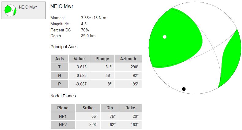
5.7 2013/03/10 16:49:20 -5.304 151.512 60.0 NEW BRITAIN REGION, PAPUA NEW GUINEA
ha! earthquakes eh, you never know they are coming until they happen.
no those are aftershocks of this one
6.5 2013/03/10 22:51:52 -6.653 148.155 28.9 NEW BRITAIN REGION, PAPUA NEW GUINEA
thats the trouble with global incident map site, its only the last days data.
you missed it!
Not to say there couldn't be another one, like a mag 7+ there.
I thought that 5.7 I posted in the morning on the New Britain Island was a decent sized one in itself, I wasn't to know at the time that it was a foreshock of the 6.5.
5.7 2013/03/10 16:49:20 -5.304 151.512 60.0 NEW BRITAIN REGION, PAPUA NEW GUINEA
ha! earthquakes eh, you never know they are coming until they happen.
Originally posted by muzzy
reply to post by BO XIAN
wait until I get to doing the historic data back to 1831BC, Taiwan is obliterated with icons, you can't see any towns or features on the map unless you zoom into almost ground level, its a wonder anyone survived!
THX for your kind reply.
When I lived there . . . there was a 6.X quake down island that killed many. IIRC it was in a mostly rural area but nearby towns saw the collapse of many buildings.
There's a railway on the Eastern side of the Island . . . and a stretch of the train track bed is constantly moving. They have to routinely redo the track there fairly frequently.
I had the honor of editing the professional English papers for one of Taiwan's top geologists. I think he's the best but he'd humbly argue with that because someone outranks him at the UNIV due to seniority, IIRC. LOL.
Multiple mag 5+ coming in to southern California
usgs
In GEE, it looks like 8 millimeters/sec amplitude in the north-south, and east-west directions. Only 2mm/sec in the vertical.
ugh! The particulars keep changing. It looks like these were incredibly shallow.
Revisions to the 3 quakes above:
I expect these will change several times more, lol. Still, looking at the seismos (for example, PB 084 Anza ) the shaking lasted at least 30 seconds. Lots of aftershocks, which is good. This looks to have occurred near the San Jacinto fault, not the SAF.
5.2 20km ESE of Anza, California 2013-03-11 16:56:05 33.498°N 116.462°W 0.1
5.2 20km ESE of Anza, California 2013-03-11 16:55:50 33.503°N 116.457°W 12.1
5.2 19km ESE of Anza, California 2013-03-11 16:55:42 33.506°N 116.476°W 0.1
usgs
edit on 3/11/2013 by Olivine because: (no reason given)
In GEE, it looks like 8 millimeters/sec amplitude in the north-south, and east-west directions. Only 2mm/sec in the vertical.
edit on
3/11/2013 by Olivine because: (no reason given)
ugh! The particulars keep changing. It looks like these were incredibly shallow.
edit on 3/11/2013 by Olivine because: (no reason
given)
Revisions to the 3 quakes above:
4.6 20km ESE of Anza, California 2013-03-11 16:56:05 33.498°N 116.462°W 0.1
4.7 20km ESE of Anza, California 2013-03-11 16:55:50 33.503°N 116.457°W 12.1
4.7 19km ESE of Anza, California 2013-03-11 16:55:42 33.506°N 116.476°W 0.1
I expect these will change several times more, lol. Still, looking at the seismos (for example, PB 084 Anza ) the shaking lasted at least 30 seconds. Lots of aftershocks, which is good. This looks to have occurred near the San Jacinto fault, not the SAF.
edit on 3/11/2013 by
Olivine because: last one, I promise
new topics
-
Gallant Opposes Israeli Governance of Gaza
Middle East Issues: 1 hours ago -
Biden plans executive order to shut down border once crossings reach 4,000 per day
US Political Madness: 3 hours ago -
Mebendazole Video
Medical Issues & Conspiracies: 4 hours ago -
ETA Found Thanks - I need help finding the ATS GOLD content contributor Image
General Chit Chat: 7 hours ago -
Biden accepts Trumps debate challenge
2024 Elections: 8 hours ago -
Canada wants to kill off the brown people
Mainstream News: 8 hours ago -
10 Year Old Indiana Boy Victim of Bullying Commits Suicide
Education and Media: 10 hours ago -
Want Some Secret Knowledge?
Paranormal Studies: 10 hours ago -
Slovakian prime minister shot in 'brutal' attack while meeting supporters
Mainstream News: 11 hours ago -
WATCH 1740 Russian Soldiers Destroyed By Ukrainian Forces While Advancing In Kharkiv
World War Three: 11 hours ago
top topics
-
Ohio finds over 100 non-citizens on votrer roles
US Political Madness: 14 hours ago, 13 flags -
Biden accepts Trumps debate challenge
2024 Elections: 8 hours ago, 10 flags -
10 Year Old Indiana Boy Victim of Bullying Commits Suicide
Education and Media: 10 hours ago, 9 flags -
Biden plans executive order to shut down border once crossings reach 4,000 per day
US Political Madness: 3 hours ago, 9 flags -
Slovakian prime minister shot in 'brutal' attack while meeting supporters
Mainstream News: 11 hours ago, 8 flags -
Mebendazole Video
Medical Issues & Conspiracies: 4 hours ago, 7 flags -
Canada wants to kill off the brown people
Mainstream News: 8 hours ago, 5 flags -
Meeting of a Russian hunter with a bear
ATS Skunk Works: 15 hours ago, 4 flags -
Want Some Secret Knowledge?
Paranormal Studies: 10 hours ago, 3 flags -
ETA Found Thanks - I need help finding the ATS GOLD content contributor Image
General Chit Chat: 7 hours ago, 3 flags
active topics
-
Silent Weapons
General Conspiracies • 17 • : IndieA -
Slovakian prime minister shot in 'brutal' attack while meeting supporters
Mainstream News • 18 • : annonentity -
Gaza Genocide Real or Propaganda
Middle East Issues • 428 • : FarqQ -
Anybody else go to the movie theater a lot? Have you noticed how dead they are?
General Chit Chat • 32 • : stonerwilliam -
Biden accepts Trumps debate challenge
2024 Elections • 93 • : FarqQ -
Mood Music Part VI
Music • 3210 • : YourHighness -
Meeting of a Russian hunter with a bear
ATS Skunk Works • 35 • : Zanti Misfit -
Biden plans executive order to shut down border once crossings reach 4,000 per day
US Political Madness • 24 • : MetalThunder -
The biggest problem with the Hush money trial
US Political Madness • 254 • : JadedGhost -
Canada wants to kill off the brown people
Mainstream News • 10 • : FarqQ