It looks like you're using an Ad Blocker.
Please white-list or disable AboveTopSecret.com in your ad-blocking tool.
Thank you.
Some features of ATS will be disabled while you continue to use an ad-blocker.

Nasty Extra terrestrials operating a base LIVE in Alaska, this is huge.
page: 17share:
reply to post by RevelationGeneration
Jaja the truth, more like 'I just found the delusion as it's easier to believe'
_________________________
Looking forward to more info on this Pyramid. Any actual pictures?
Jaja the truth, more like 'I just found the delusion as it's easier to believe'
_________________________
Looking forward to more info on this Pyramid. Any actual pictures?
edit on 30-7-2012 by Imtor because: (no reason given)
Originally posted by Imtor
@Tundra, just saying some hurry to debunk all without even reading like yelling and barking like some dogs, never mind
The case looks interesting, I always found Alaska an interesting state and probably a place I'd like to lie, away from the noisy cities, then I would love to see your alien encounters that happen so often...
Aah- right- no problem. Yes, I agree.
I looked again a the article. In particular, it says that
Combined with the graphs from the previous page, this is really confusing.
a) there is pyramid drawn into the graphs, but its dimensions are much smaller than these of the Egyptian pyramids
b) there is no information of how the shape of the alleged pyramids was deduced from the sensor data
c) likewise, it's completely unclear how one can be unsure of whether the object they claim to have observed is hollow or solid, while they apparently made an effort to interpret the data.
But all of this is a bit of finesse, main point being that the title of this thread is completely unfounded, fake and sensationalist to the point of being idiotic.
What the geologists said they found in this byline news story (Anchorage TV Channel 13) story was under Alaska, they found a pyramid bigger than the one in Egypt. They said they did not know if it were solid or hollow.
Combined with the graphs from the previous page, this is really confusing.
a) there is pyramid drawn into the graphs, but its dimensions are much smaller than these of the Egyptian pyramids
b) there is no information of how the shape of the alleged pyramids was deduced from the sensor data
c) likewise, it's completely unclear how one can be unsure of whether the object they claim to have observed is hollow or solid, while they apparently made an effort to interpret the data.
But all of this is a bit of finesse, main point being that the title of this thread is completely unfounded, fake and sensationalist to the point of being idiotic.
Originally posted by Char-Leeas far as satellite finds there have been a ton
NASA satellite 'helps find 17 Egypt pyramids'
www.google.com...
NASA, university scientists uncover lost Maya ruins --- from space
www.thepanamanews.com...
Including the worlds largest yet known pyramid.
Yeah, but that's one heck of a lot different tech than seismic readings. For example, LIDAR and other such things are being used to penetrate dense vegetation to 'see' anomalies on the surface. Those types of surveys are completely unrelated to seismic surveys.
The geologist at the end of the article is absolutely correct. I work in archaeology, and we use a number of different subsurface survey instruments and techniques (ground penetrating radar, conductivity, etc.), but even when you're standing directly on top of something the profiles are often not all that conclusive or high resolution. You'll get an anomaly in the reading and then you have to either run test pits, auger tests, or some other type of direct, hands-in-the-dirt analysis. And that's when you're literally standing on top of the feature with whatever device you're using.
When they do seismic surveys for, say, petroleum or mineral exploration they, as the article suggests, have a unit that hits the ground at a very specific frequency. Prior to the actual 'hitting' of the ground, they've strung out miles and miles of wired sensors in the form of a grid so with every strike they get a bunch of returns from the sensors. Then, once the tests have been run, they compile all of that data and come up with a 3d model of the structure of the crust. Even at that point, they'll only have a rough guess where deposits may or may not be. They'll still have to sink test wells, etc. The oil companies spare absolutely no expense doing these seismic tests, and many of them have tech that the government-funded (and the military) would love to have. Vast oil or gas deposits aren't perfectly profiled, so even with the grid sensor type tests a pyramid would almost certainly not be clear or even visible at all.
An underground nuclear test is valuable only in that it allows them to look at much larger areas, but the resolution is very, very low. Second, it's a one time event with no above ground sensor data to create a true profile. In other words, what the article describes is simply not scientifically possible.
reply to post by samcrow
I wish I could give you more than one star. Finally, someone who knows what they are talking about.
My intuition was the same, that it's pretty damn impossible to do "tomography" on whatever object was said to exist, using just one shock wave coming from China.
I wish I could give you more than one star. Finally, someone who knows what they are talking about.
My intuition was the same, that it's pretty damn impossible to do "tomography" on whatever object was said to exist, using just one shock wave coming from China.
reply to post by samcrow
This article is interesting..
Nuclear Test Sound Waves Help Scientists Map Earth's Interior
articles.latimes.com...
This article is interesting..
Nuclear Test Sound Waves Help Scientists Map Earth's Interior
articles.latimes.com...
Originally posted by Char-Lee
reply to post by samcrow
This article is interesting..
Nuclear Test Sound Waves Help Scientists Map Earth's Interior
articles.latimes.com...
Right...just like they used the nuclear test to 'map' the crust. It certainly works and works well for what it is: a way to get a rough idea about the geology of huge areas. The key is the resolution. You're not going to see small breaks in the strata, etc. with a simple seismic test from a nuclear detonation. You can, however, see 'big' breaks like fault lines and also larger changes in the geology from one area to the next. Think of it this way: Lets say somebody buries a granite boulder the size of a pyramid in a sandstone deposit. Grid testing like I mentioned for petroleum exploration MIGHT pick that up depending on the equipment, and that's only because of a dramatic difference in density between the sandstone and the granite. A granite boulder artificially placed amongst other granite will not be visible at all. A nuclear detonation test from thousands of miles will not pick it up at all, regardless of the surrounding rock. Now, lets say that same boulder is the size of Iowa and placed in sandstone. The nuclear test will probably see it then. Geologists using the nuclear detonation information aren't looking for small things, they're after data about the crust over tens of thousands of square miles.
edit on 30-7-2012 by samcrow because: (no reason given)
Originally posted by buddhasystem
reply to post by samcrow
I wish I could give you more than one star. Finally, someone who knows what they are talking about.
My intuition was the same, that it's pretty damn impossible to do "tomography" on whatever object was said to exist, using just one shock wave coming from China.
Well, there are certainly things I don't know, but this is one I'm familiar with.
Tomography certainly exists and is used for geology, but they're doing multiple tests and using ground sensors in the case of 'small' areas like huge magma pockets under, say, Yellowstone and they're taking a rough, mathematical guess when looking at things like subduction, etc.
Originally posted by samcrow
Originally posted by buddhasystem
reply to post by samcrow
I wish I could give you more than one star. Finally, someone who knows what they are talking about.
My intuition was the same, that it's pretty damn impossible to do "tomography" on whatever object was said to exist, using just one shock wave coming from China.
Well, there are certainly things I don't know, but this is one I'm familiar with.
Tomography certainly exists and is used for geology, but they're doing multiple tests and using ground sensors in the case of 'small' areas like huge magma pockets under, say, Yellowstone and they're taking a rough, mathematical guess when looking at things like subduction, etc.
That's what I figured. In this case, however, what came into the observation region was already a product of propagation/reflection/distortion, since the wave traveled such a great distance. Impossible to get any resolution at all, imho.
Originally posted by petertheskinny
Oh my god, no freakin wonder US government wants to legislate and control the internet, all the secrets are coming out.
Check this out
Tonight on Coast to Coast, ex Military intel analyst contacted a woman that works for CTC as a investigative journalist. He gives her proof on who he was and tells her there is a Ancient Pyramid in Alaska bigger than the biggest one in Egypt. Located between Noam and Mcinelly mountain.
It was discovered due to Chinese underground nuke test that allowed US sensors to pick up a Pyramid in Alaska.
Now get this, he was told while trying to dig into this in the past, that he doesn't have clearance for full disclosure but that "they" [aliens] don't want us mucking around their base anyway.
Now get this, there were huge number of disappearances in Alaska, it doesn't take a genius to figure out why, people are being abducted and not returned.
And why stop here, it doesn't take a genius to figure out that even pyramids in Giza Egypt obviously have ET connection in the past.
Except the Alaskan underground pyramid is HOT and HUMMING, an active base, run by morally destitute Aliens who use humans for occasional food, sex slaves, toys, you name it.
There you go ATS, you now know even more than US President, you know that fool don't have the need to know.
This is why skeptics have ammo to fire back, and call believers loony tune.
talk about misinterpreted !
no where in that podcast were any of these things mentioned. they don't even know if it's hollow, all they know is that there is a pyramid shape under the ground, and their not even positive of that. Get a grip Dude !
Originally posted by dabs1903
Sounds pretty close to the plot of Alien vs. Predator only with sex added.
I have a feeling that the next installment of the franchise will be titled "Alien does Predator".
Originally posted by buddhasystem
Originally posted by dabs1903
Sounds pretty close to the plot of Alien vs. Predator only with sex added.
I have a feeling that the next installment of the franchise will be titled "Alien does Predator".
Or how to catch an illegal alien predator?
Well, so far this thread was a disappointment. I was hoping to see something astounding but it's nothing without proof. I'm waiting for the next season of ancient aliens when this is said to be a proven archeological discovery but reserved for the black operatives so that's why we don't know anything about it. As we all know, black operatives are like ninjas. (yay, two ninja references today!)
reply to post by Em2013
to catch a predator like this?
Also, yeah there is nothing to this theory. There is no way some CW2 would even have a chance at getting access to the documents he supposedly saw before they told him not to look at it, in a room full of safes holding it haha.
to catch a predator like this?
Also, yeah there is nothing to this theory. There is no way some CW2 would even have a chance at getting access to the documents he supposedly saw before they told him not to look at it, in a room full of safes holding it haha.
edit on 31-7-2012 by deathlord because: wrong word
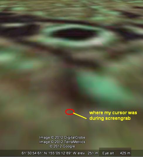
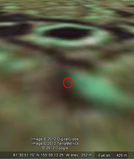
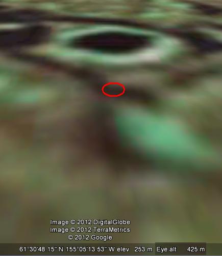
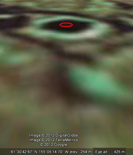
Explanation: The ??? anomaly investigated as promised ...
Looking DUE South ...
Lowest point in that area ..below the anomaly by 3m with land altitude of 251m.
1m up from lowest point with land altitude of 252m.
2m up from lowest point with land altitude of 253m.
3m up from lowest point .. the anomally itself with land altitude of 254m.
Theoretically shouldn't the water ... if it is water ... pool to the lowest point, which is a full 3m below the ??? anomaly?
In discussing this with my fellow chat member muzzleflash we also both agreed it seems to be hexagonal in shape ... could it be a landing pad or even an alien spacecraft/ufo?
Personal Disclosure: This just gets weirder and weirder!
Just going to clarify a few misconceptions, not that I believe this is true:
First,
America developed the technology to detect nuclear tests years ago. Above ground tests are generally detected by satellites. However, due to a layer of the earths crust, the lithosphere, being basically a semi-liquid rock, shock waves travel through there in "p" and "s" waves all around the world. The USGS is able to detect an earthquake in Japan even if we can't feel it here based on the sensors in the ground picking up the shockwave. The waves can be blocked by solid objects in the ground, which is where the "pyramid" claim originates. Keep in mind the guy said it was an underground pyramid, not an above ground one. This alone should help resolve half of the problems in the thread.
During our own nuclear testing, figuring out what a nuke test underground "looked" like on those sensors was certainly accomplished. So, the idea that we were monitoring the earths crust during the Chinese test is legit. That is one of the ways we busted them for doing the test. We also picked up what we thought to be a NK nuke test in 2006 using the same technology.
Second,
China did in fact test a nuke that year in the location mentioned. It was an effort to demonstrate their nuclear capabilities which were until that time known but their abilities doubted due to commie regimes always spitting out propaganda.
Third,
Coast to Coast is sensationalism at its worst and should not be trusted as a news source in 99% of the cases. This man, if any of his information was feasible or true, would have received front page coverage in our enemies media if not our own. Also, those of you looking for above ground pyramids are in the wrong place, the man claimed they were underground, not above ground. If they were above ground we'd know about it by now.
I still think this is a crock, but the means he claims in the seismic monitoring is the only part of his story that checks out. I hope I've clarified some confusion here.
Cheers
edit on 1-8-2012 by AnnunakiJihad because: (no reason given)
edit on 1-8-2012 by AnnunakiJihad because:
clarification
Originally posted by AnnunakiJihad
I still think this is a crock, but the means he claims in the seismic monitoring is the only part of his story that checks out. I hope I've clarified some confusion here.
No you haven't, because as was commented by an expert in this thread it's impossible to do mapping with THAT sort of precision using a source THAT distant.
Originally posted by petertheskinny
Except the Alaskan underground pyramid is HOT and HUMMING, an active base, run by morally destitute Aliens who use humans for occasional food, sex slaves, toys, you name it.
There you go ATS, you now know even more than US President, you know that fool don't have the need to know.
What nonsense. Just stick to the facts of the interview without the conjecture.. The reality is that we do way worse things to each other, than 'they' have ever been accused of doing to us.
First, to all skeptics out there - would you at least have the intellectual honesty to read and view the original documents in full?
Once you have done that, I hope at least half of you will have the cojones to come back here and admit you've dismissed this out of hand, and not based on some rational thought.
Let's quickly summarize the FACTS:
- this guy IS ex-army counter-intel;
- he WAS stationed in alaska;
- there WAS a chinese underground nucelar test that year;
- these tests CAN be used to map the geological crust, albeit not in great detail;
Here are other things we know for a FACT:
- there ARE tens of pyramids throughout the world, not just in Egypt, and stone cannot be carbon dated; so the idea that there could be one in North America IS NOT far fetched.
- examination of said coordinates by several ex-navy photo analysts and engineers SHOW the base of a pyramidal structure buried beneath the ground, its dimensions BEING EXACTLY twice that of the pyramid in Cheops;
Feel free to add anything I might have missed.
Now, what I don't get is how most of you just blatantly IGNORE THESE FACTS and, through a less-than-average mix of humor, scorn and arrogance, dismiss the whole story as "fiction".
Haha, indeed.
I try to be as analytical and bias-free as I can; and I reserve my conclusions for after a close examination of the facts (that is, btw, my own, humble attempt at being intellectually honest). In this case, the facts indicate that, in all probability, there is indeed something to this story.
As one member put it, "if there's something fishy here, it's probably the fish".
That doesn't mean it necessarily happened exactly as this guy said - we all have a tendency to interpret things our own way, don't we? - nor does it mean it relates to aliens. But one cannot simply ignore the cross-relevance of these facts when put together.
So, the question is not whether the guy's narrative is "true" or "false", but rather what IS the TRUTH?
I am interested to hear how/why we should, as some of you seem eager to do, dismiss these facts altogether and stop all inquiry into this subject here and now.
Besides a 15 pg rehash of actual info [regardless of it's reliability] what's the most astounding is NO ONE from that area of alaska has weighed in!
No one here has correlated missing person's reports from the local newspaper up there either.
edit on 1-8-2012 by Caver78 because: (no reason given)
reply to post by buddhasystem
You would be surprised. You're not measuring anything from distance. The waves travel all around the world, you measure them when they're in your backyard minutes after the event due to the speed of which these waves travel. This is Geology 101 man. You're looking at it as one wave sent from the test. It's more than just one. Due to the elasticity of the lithosphere we can detect any seismic event anywhere in the world. Why do you think its the USGS that issues all of the alerts world wide for tsunamis and earthquakes and in a lot of cases volcanic events? It's because we have sensors everywhere, from military sonar nets in every ocean to track submarines, to drilled sensors at both poles. America loves to spend money on this.
I worked as a seismologist's assistant in college. We used to pick up all kinds of stuff on those sensors. It's not one wave, it's a bunch of "out of place" waves we detected. Think of it as a crust level "white capping" of a body of water. There isn't one white capped wave now is there?
edit on 1-8-2012 by AnnunakiJihad because: (no reason given)
edit on 1-8-2012 by AnnunakiJihad because:
clarification
edit on 1-8-2012 by AnnunakiJihad because: (no reason given)
new topics
-
How much did Doctors get bribed
Diseases and Pandemics: 43 minutes ago -
DEI is dead at UNC!
US Political Madness: 4 hours ago -
US Defense (DIA) Officer Maj. Harrison M. resigned in protest of killing Palestinian civilians
Politicians & People: 5 hours ago -
Frances Scott Key Bridge Demolition To Free Dali Scheduled For 5PM Eastern Standard Time.
Other Current Events: 5 hours ago -
"I Want Mercy Not Sacrifice"
Conspiracies in Religions: 5 hours ago -
San Francisco Program To Give Free Booze to the Homeless
Social Issues and Civil Unrest: 6 hours ago -
Avatar Crucifix in my baked potato! Before surgery + more. Palestinian nurse, Christian patient.
General Chit Chat: 7 hours ago -
Senator Karim Bianchi, from Chile, telling was abducted 2012.
Aliens and UFOs: 9 hours ago -
Gaza Genocide Real or Propaganda
Middle East Issues: 10 hours ago
top topics
-
DEI is dead at UNC!
US Political Madness: 4 hours ago, 14 flags -
San Francisco Program To Give Free Booze to the Homeless
Social Issues and Civil Unrest: 6 hours ago, 8 flags -
Avatar Crucifix in my baked potato! Before surgery + more. Palestinian nurse, Christian patient.
General Chit Chat: 7 hours ago, 8 flags -
Don Trump-Quixote
Political Issues: 16 hours ago, 7 flags -
Akkabadori: history of tolerant euthanasia
History: 14 hours ago, 7 flags -
Gaza Genocide Real or Propaganda
Middle East Issues: 10 hours ago, 7 flags -
Frances Scott Key Bridge Demolition To Free Dali Scheduled For 5PM Eastern Standard Time.
Other Current Events: 5 hours ago, 4 flags -
Paranoia that will tear apart Russia and China
World War Three: 17 hours ago, 4 flags -
Senator Karim Bianchi, from Chile, telling was abducted 2012.
Aliens and UFOs: 9 hours ago, 4 flags -
"I Want Mercy Not Sacrifice"
Conspiracies in Religions: 5 hours ago, 2 flags
active topics
-
Gaza Genocide Real or Propaganda
Middle East Issues • 173 • : NorthOS -
-@TH3WH17ERABB17- -Q- ---TIME TO SHOW THE WORLD--- -Part- --44--
Dissecting Disinformation • 999 • : daskakik -
SecretKnowledge sez howaryiz all, im back.
Introductions • 7 • : SchrodingersRat -
President Bidens Health is Declining Faster 5.8.2024 - He Should Stay Home.
2024 Elections • 52 • : SchrodingersRat -
San Francisco Program To Give Free Booze to the Homeless
Social Issues and Civil Unrest • 39 • : sine.nomine -
Why Did JOE BIDEN and Family Receive Tens of Millions of Dollars From Non-US Sources.
2024 Elections • 79 • : whyamIhere -
Christianity superior to other faiths for very specific reasons. Awaken to true FREEDOM..!!
Conspiracies in Religions • 45 • : jofafot -
Egypt to join South Africa genocide case at ICJ
Middle East Issues • 51 • : ToneD -
How much did Doctors get bribed
Diseases and Pandemics • 1 • : whyamIhere -
Kirkpatrick vs Fugal - Skinwalker ranch briefing.
Aliens and UFOs • 30 • : Ophiuchus1